List of earthquakes in Italy

Last updated

The seismic hazard map of Italy showing the probability of seismic activity for different places in Italy. Italy earthquake hazard usgs(1).jpg
The seismic hazard map of Italy showing the probability of seismic activity for different places in Italy.
Map of earthquakes in Italy 1900-2017 Map of earthquakes in Italy 1900-2017.png
Map of earthquakes in Italy 1900-2017
Earthquakes M5.5+ (1900-2016) Mediterranean EQs 1900-2016 mediterranean tsum.png
Earthquakes M5.5+ (1900–2016) Mediterranean

This is a list of earthquakes in Italy that had epicentres in Italy, or significantly affected the country. On average every four years an earthquake with a magnitude equal to or greater than 5.5 occurs in Italy. [1]

Contents

Due to the particular geodynamic situation (convergence of the Eurasian Plate with the African Plate) the Italian territory is frequently subject to earthquakes, giving it the record in Europe for these phenomena. [2] Out of 1,300 destructive earthquakes that occurred in the 2nd millennium in the central Mediterranean Sea, 500 affected Italy. [3]

The analysis of the earthquakes indicates that they are mostly distributed along the areas affected by Alpine and Apennine tectonics, where they are caused by movements along faults. [4] The highest seismicity hazard in Italy has been concentrated in the central-southern part of the peninsula, along the Apennine ridge, in Calabria and Sicily and in some northern areas, like Friuli-Venezia Giulia, part of Veneto and western Liguria.

Geology

Italy lies on the southern extent of the Eurasian Plate, which is surrounded by the Aegean Sea Plate, the Adriatic Plate, and the Anatolian Plate. The Apennine Mountains contain numerous faults that run along the entire Italian peninsula and form the majority of the destructive boundary between the Eurasian and the Adriatic Plates, thus causing Italy to have high amounts of tectonic activity. In addition, Sicily and Calabria are located near the boundary where the African Plate is subducting below the Eurasian Plate, which was responsible for forming the stratovolcano known as Mount Etna.

List of major earthquakes

DateRegion Mag. MMI DeathsInjuriesNotesRef
2023-09-18 Tuscany 5.1 MwVI11Severe damage [5] [6]
2023-03-09 Umbria 4.3 Mw
4.6 Mw
IV13Severe damage [7] [8]
2022-11-09 Pesaro-Urbino 5.6 MwVI11Moderate damage [9] [10]
2020-02-24 Calabria 4.8 MwVI1Moderate damage [11] [12]
2018-12-26 Sicily 5.0 MwVII30Several buildings damaged [13] [14]
2018-08-16 Molise 5.3 MwVI2Moderate damage [15] [16]
2017-08-21 Campania 4.2 MwVI242
2017-01-18 Abruzzo, Lazio 5.7 MwVIII3429Sequence
2016-10-30 Umbria 6.6 MwXI3 (indirect)DozensSequence / extensive damage
2016-08-24 Lazio, Umbria, Marche 6.2 MwXI299>400
2013-06-21 Tuscany 5.2 MwV4 [17] [18]
2013-02-16 Lazio 4.8 MwV1 (indirect) [19] [20]
2012-05-29 Emilia-Romagna 5.8 MwVII20350
2012-05-20 Emilia-Romagna 6.1 MwVII5 (+2 indirect)50
2010-08-16 Sicily 4.5 Mw7Landslides [21] [22]
2009-04-06 L'Aquila 6.3 MwX3091,500+Severe damage
2004-11-24 Lombardy, Salò 5.1 MwVII–VIII *9Many buildings damaged [23]
2003-09-14 Emilia-Romagna 5.3 MwVIISome10 buildings damaged [24]
2003-04-11 Piedmont, Alessandria 5.0 MbVI *2 [25]
2002-11-01 Molise 5.8 Mw3 Doublet / additional damage [26]
2002-10-31 Molise 5.930 Doublet
2002-09-06 Sicily 6.0 Mw220Heart attacks / damage [27]
2001-07-17 Trentino-Alto Adige 4.7 MwVI *33Landslides [28]
1998-09-09 Basilicata, Calabria 5.6 MwVI–VII *212Buildings damaged [29]
1997-09-26 Umbria, Marche 6.19 Doublet
1997-09-26 Umbria, Foligno 5.72 Doublet
1991-05-26 Basilicata, Potenza 5.1 MbVIIIA fewMinor damage [30]
1990-12-13 Sicily, Augusta 5.6 MwVII19200Severe damage [31]
1990-05-05 Basilicata, Campania 5.8 MwVII216 [32]
1987-05-02 Emilia-Romagna 4.8 MbVII1SeveralSlight damage [33]
1985-03-14 Molise 4.3 MwV1Slight damage [34]
1984-05-07 Abruzzo, Lazio 5.9 MwVIII3100Extensive damage [35]
1984-04-29 Umbria, Gubbio 5.7 MwVIII36Extensive damage [36]
1983-11-09 Emilia-Romagna 5.1 MwVIII100Some damage [37]
1980-11-23 Campania, Basilicata 6.9 MwX2,483–4,9007,700–8,934Extreme damage
1979-09-19 Umbria, Norcia 5.8 Ms55,000Severe damage NGDC
1978-04-15Gulf of Patti, Sicily 5.7 Ms5Moderate damage NGDC
1978-03-11 Sicily 5.0 Ms22Moderate damage NGDC
1976-09-15 Friuli 5.9/6.08 (+3 indirect)Aftershock
1976-09-11 Friuli 5.8/5.62 (indirect)Aftershock
1976-05-06 Friuli 6.5 MwX900–9781,700–2,400Extreme damage
1972-06-14 Ancona 4.9IXExtensive damage / swarm [38]
1971-07-15 Emilia-Romagna 5.2 MbVIII *2Limited damage NGDC
1971-02-06 Lazio 4.6 MbVIII24150Extreme damage NGDC
1969-08-11 Perugia 4.7 MsVII4Limited damage NGDC
1968-01-15 Western Sicily 5.5 MwX231–400632–1,000Sequence
1962-08-21 Irpinia, Campania 6.1IX *16Moderate damage
1943-10-03 Offida, Marche 5.5 MwIX15Very heavy damage [39]
1936-10-18 Cansiglio 5.9 MLIX19
1933-09-26 Abruzzo 5.6 MwIX10Some damage [40] [41]
1930-10-30 Senigallia, Marche 5.918
1930-07-23 Irpinia 6.6 MsX1,4044,624–7,000
1920-09-07 Garfagnana 6.4171 [42]
1917-04-26Northern Umbria 5.820
1915-01-13 Avezzano 6.7 MwXI29,978–32,610Extreme damage
1914-05-08 Sicily 4.9 MsX120Severe damage NGDC
1908-12-28 Strait of Messina 7.1 MwXI75,000–200,000Extreme damage / tsunami
1907-10-23 Calabria 5.9 MsVIII–X158–167Moderate damage NGDC
1905-09-08 Calabria 7.2 MwXI557–2,500Tsunami
1901-10-30 Salò 5.5 MwVII–VIIICollapsed buildings [43]
1894-11-16 Strait of Messina, Sicily, Calabria 6.0IX100Severe damage [44]
1887-02-23 Liguria 6.2–6.5>2,000Significant damage / tsunami [45] [46]
1883-07-28 Ischia 4.3–5.2 MwXI2,313Near total destruction on in Ischia
1873-06-29 Veneto 6.3 MeIX–X80
1857-12-16 Basilicata 7.0 MwXI10,000Extreme damage
1851-08-14Basilicata700–2,000+Many buildings damaged [47] [48]
1836-04-25 Calabria 6.1X239Severe damage [49]
1831-05-26 Taggia, Sanremo 5.5VIII-IXModerate damage [50]
1828-10-09Ligurian Apennines, province of Alessandria 5.8VII-VIII19Moderate damage [51]
1808-04-02 Piedmont 5.7VIII2Moderate damage [52]
1805-07-26 Campania, Molise 6.6 MeX5,573Extreme damage
1802-05-12 Lombardy, Cremona 5.7 MwVIII-IX2Collapsed churches, houses, and a municipal building [53] [54] [55]
1783-02-04 Calabria 7.050,000 [42]
1762-10-06 L'Aquila 5.3–6.0 Mw IX Damage [56]
1743-02-20 Salento 7.1 MwIX180–300
1732-11-29 Campania 6.6Thousands [57]
1706-11-03 Abruzzo 6.6-6.84 MwX2,400Extreme damage
1703-02-12 L'Aquila 6.7XI2,500–5,000
1703-01-16 Montereale 6.2VIII
1703-01-14 Norcia 6.7X6,240–9,761
1694-09-08 Basilicata 6.9>6,000
1693-01-11 Sicily, Malta 7.4 MwXI60,000
1688-06-05 Sannio 7.0XI3,311Severe damage NGDC
1659-11-06 Calabria 2,035Extreme damage NGDC
1654-07-23 Sorano, Marsica X600Severe damage NGDC
1639-10-07 Lazio 6.0 MwIX–X500
1638-06-09 Calabria IX52Moderate damage
1638-03-27 Calabria 7.0 MsXI9,581–30,000Extreme damage / tsunami [58]
1627-07-30 Apulia 6.7 MwX5,000Tsunami
1626-07-30 Naples 70,000
1626-04-05 Girifalco 6.1 MwXVery heavy damage
1616-06-04 Cagliari No casualties or damage reported. Registeted on a plaque in the city's cathedral
1570-11-17 Ferrara 70–200
1561-08-19 Vallo di Diano 6.4 MwX500 [59]
1517-03-29 Irpinia 5.4 Mw>50Moderate damage [60]
1511-03-26 Friuli X15Severe damage
1466-01-15 Irpinia 6.1VIII-IX>100 [61]
1461-11-27 L'Aquila 6.3IX>80High intensity over Abruzzo region
1456-12-30 Benevento 6.6 MwX–XISequence
1456-12-05 Molise 7.1–7.4 MwX–XI30,000–70,000High intensity over large area. Largest earthquake on the Italian Peninsula. [62]
1453-09-28 Florence 5.3VII-VIIIModerate damage [63]
1361-07-17 Ascoli Satriano 6.0>1,000Extreme damage [64]
1349-09-09 L'Aquila 6.7X2,000Severe damage NGDC
1348-01-25 Friuli 6.9X10,000Extreme damage
1343-11-25 Naples Tsunami
1328-12-04 Norcia 6.4X2,000-5,000 [65]
1315-12-03 L'Aquila 5.6IXModerate damage [66]
1298-12-01 Monti Reatini 6.3XNumerous deaths and severe damage [67]
1293-09-04 Samnium, Naples 5.8VIII-IXModerate damage [68]
1222-12-25 Northern Italy X12,000Extreme damage
1169-02-04 Sicily X15,000–25,000Severe damage / tsunami
1117-01-03 Northern Italy VIISevere damage
1046-11-09 Valle dell'Adige IX-XNumerous deaths and severe damage [69]
801-04-29 Central Apennines 5.4 MeVII–VIIISevere damage [70]
951 Rossano IXSevere damage [71] [72]
853 Messina IX-XSevere damage [73]
847 Samnium Severe damage [74]
801-04-29 Spoleto, Perugia Severe damage [75]
778 Treviso VIII-IX48Moderate damage [71] [76]
725 Classe VIIIModerate damage [71] [77]
584 Liguria Severe damage [78]
375 Benevento IXSevere damage [71]
369-07-21 Benevento ThousandsSevere damage [71]
361 Sicily and Calabria XDrastic decrease in the population along the Strait of Messina Extreme damage / tsunami [71] [79]
346 Samnium IXSevere damage [71] [80]
101 San Valentino in Abruzzo Citeriore IX-XSevere damage [71] [81]
99 Circello, Benevento IX-XSevere damage [71] [82]
79-08-24 Vesuvian areaVIIIThousandsEarthquake caused by the catastrophic eruption of Mount Vesuvius in 79 AD [71]
62-02-05 Campania 5.2–6.1IX–XSevere damage
56 BC-04 Potenza Picena VIII-IXSevere damage [71] [83]
91 BC Modena, Reggio Emilia VIIIModerate damage [71]
100 BC Marche VIII-XSevere damage [71] [84]
217 BC-06 Etruria XSevere damage [71]
Note: The NGDC has records for significant events that go back several thousand years BCE. Added for source diversity, the United States Geological Survey reports are sufficient from the early 1980s to the present. Occasionally, these sources omit the maximum felt intensity. Rovida et al. 2011 can help fill in some of the gaps. Intensity values derived from this source are indicated with an asterisk. The inclusion criteria for adding events are based on WikiProject Earthquakes' notability guideline that was developed for stand alone articles. The principles described also apply to lists. In summary, only damaging, injurious, or deadly events should be recorded.

See also

Related Research Articles

AD 62 (LXII) was a common year starting on Friday of the Julian calendar. At the time, it was known as the Year of the Consulship of Marius and Afinius. The denomination AD 62 for this year has been used since the early medieval period, when the Anno Domini calendar era became the prevalent method in Europe for naming years.

A volcano observatory is an institution that conducts research and monitoring of a volcano.

An earthquake occurred northeast of the city of Adana in the Armenian Kingdom of Cilicia on 14 May 1269 at "the first hour of the night". Most sources give a death toll of 8,000 in the Armenian Kingdom of Cilicia in southern Asia Minor, but a figure of 60,000 dead was reported by Robert Mallet in 1853 and repeated in many later catalogues.

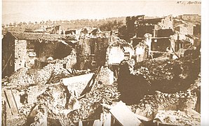
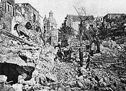
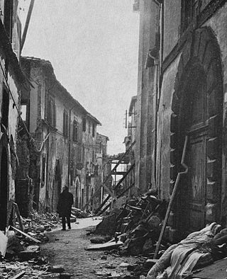
The 1980 Irpinia earthquake took place in Italy on 23 November 1980, with a moment magnitude of 6.9 and a maximum Mercalli intensity of X (Extreme). It left at least 2,483 people dead, at least 7,700 injured, and 250,000 homeless.

The Galilee earthquake of 363 was a pair of severe earthquakes that shook the Galilee and nearby regions on May 18 and 19. The maximum perceived intensity for the events was estimated to be X on the European macroseismic scale. The earthquakes occurred on the portion of the Dead Sea Transform (DST) fault system between the Dead Sea and the Gulf of Aqaba.

On 5 February AD 62, an earthquake of an estimated magnitude of between 5 and 6 and a maximum intensity of IX or X on the Mercalli scale struck the towns of Pompeii and Herculaneum, severely damaging them. The earthquake may have been a precursor to the eruption of Mount Vesuvius in AD 79, which destroyed the same two towns. The contemporary philosopher and dramatist Seneca the Younger wrote an account of the earthquake in the sixth book of his Naturales quaestiones, entitled De Terrae Motu.

The 1920 Garfagnana earthquake occurred on 7 September in Garfagnana and Lunigiana, both agricultural areas in the Italian Tuscany region. The quake hypocenter was located 14 kilometres (8.7 mi) beneath Villa Collemandina. The maximum felt intensity was rated as X (Extreme) on the Mercalli intensity scale, and 6.6 on the Richter magnitude scale. It was one of the most destructive seismic events recorded in the Apenninic region in the twentieth century. Due to good news coverage, availability of official documents on the damage and abundance of recordings from surveillance stations throughout Europe, it was regarded as a first-rate case study to improve knowledge of tectonics and macroseismic analysis.

The 1953 Torud earthquake occurred at the northeastern border of the Great Salt Kavir in Torud, Semnan, Iran on 12 February. The shock had a moment magnitude of 6.6 and had a maximum Mercalli intensity of VIII (Severe). At least 800 people were killed.

<span class="mw-page-title-main">2012 Northern Italy earthquakes</span> Severe earthquakes centered in Emilia-Romagna, Italy

In May 2012, two major earthquakes struck Northern Italy, causing 27 deaths and widespread damage. The events are known in Italy as the 2012 Emilia earthquakes, because they mainly affected the Emilia region.

The National Institute of Geophysics and Volcanology is a research institute for geophysics and volcanology in Italy.

The Gibilmanna Observatory is a research station used for a diverse range of studies set up and run by the Istituto Nazionale di Geofisica e Vulcanologia (INGV) and it is located on Cozzo Timpa Rossa at 1005 m.a.s.l. near Cefalù, a town in the district of Palermo, Italy.

The 1627 Gargano earthquake struck Gargano and part of Tavoliere, southern Italy, at about mid-day on 30 July 1627. A "very large earthquake" caused a major tsunami, the largest seismic event ever recorded in the Gargano region, which "produced severe damage in the whole promontory", killing about 5,000 people. Four aftershocks were documented. The most extensive damage was noted between San Severo and Lesina.

<span class="mw-page-title-main">August 2016 Central Italy earthquake</span>

An earthquake, measuring 6.2 ± 0.016 on the moment magnitude scale, hit Central Italy on 24 August 2016 at 03:36:32 CEST. Its epicentre was close to Accumoli, with its hypocentre at a depth of 4 ± 1 km, approximately 75 km (47 mi) southeast of Perugia and 45 km (28 mi) north of L'Aquila, in an area near the borders of the Umbria, Lazio, Abruzzo and Marche regions. As of 15 November 2016, 299 people had been killed.

<span class="mw-page-title-main">October 2016 Central Italy earthquakes</span>

A series of major earthquakes struck Central Italy between the Marche and Umbria regions in October 2016. The third quake on 30 October was the largest in Italy in 36 years, since the 1980 Irpinia earthquake.

The 1688 Sannio earthquake occurred in the late afternoon of June 5 in the province of Benevento of southern Italy. The moment magnitude is estimated at 7.0, with a Mercalli intensity of XI. It severely damaged numerous towns in a vast area, completely destroying Cerreto Sannita and Guardia Sanframondi. The exact number of victims is unknown, although it is estimated to total approximately 10,000. It is among the most destructive earthquakes in the history of Italy.

The 1139 Ganja earthquake was one of the worst seismic events in history. It affected the Seljuk Empire and Kingdom of Georgia; modern-day Azerbaijan and Georgia. The earthquake had an estimated magnitude of 7.7 MLH, 7.5 Ms and 7.0–7.3 Mw. A controversial death toll of 230,000–300,000 came as a consequence of this event.

<span class="mw-page-title-main">1971 Tuscania earthquake</span> Earthquake in Italy

The 1971 Tuscania earthquake occurred on 6 February in Italy. It had an epicenter located halfway between Tuscania and Arlena di Castro, about 20 km west of Viterbo. It had a body wave magnitude of 4.6.

<span class="mw-page-title-main">1883 Casamicciola earthquake</span> Earthquake in Italy

The 1883 Casamicciola earthquake, also known as the Ischia earthquake occurred on 28 July at 20:25 local time on the island of Ischia in the Gulf of Naples in Italy. Although the earthquake had an estimated moment magnitude of 4.2–5.5, considered moderate in size, it caused intense ground shaking that was assigned XI (Extreme) on the Modified Mercalli intensity scale. Between 2,313 and 3,100 people lost their lives. The city also suffered great property losses, with 80 percent of all homes destroyed. This earthquake was exceptionally destructive for its magnitude mainly due to its shallow focal depth.

On December 5, 1456, the largest earthquake to occur on the Italian Peninsula struck the Kingdom of Naples. The earthquake had an estimated moment magnitude of Mw  7.19–7.4, and was centred near the town of Pontelandolfo in the present-day Province of Benevento, southern Italy. Earning a level of XI (Extreme) on the Modified Mercalli intensity scale, the earthquake caused widespread destruction in central and southern Italy. Estimates of the death toll range greatly with as many as 70,000 deaths reported. It was followed by two strong Mw  7.0 and 6.0 earthquakes to the north on December 30. The earthquake sequence is considered the largest in Italian history, and one of the most studied.

A series of mainshocks struck Calabria on March 27–28 and June 9, 1638. The first three earthquakes had moment magnitudes estimated to be Mw 6.6–7.1. On June 9, another mainshock estimated at Mw  6.7 struck the same region, causing further damage and casualties. The four earthquakes resulted in as many as 30,000 fatalities.

References

  1. "Alla scoperta dei terremoti: Dove avvengono i terremoti in Italia?". Istituto Nazionale di Geofisica e Vulcanologia.
  2. "Italia", Enciclopedia di geografia (in Italian), Garzanti, 2006, pp. 782–783, ISBN   978-8811505198
  3. "La Geologia regionale". Archived from the original on 22 July 2011. Retrieved 29 August 2010.
  4. D. Scrocca; C. Doglioni; F. Innocenti (2003). "Constraints for an interpretation of the italian geodynamics: a review". Memorie Descrittive Carta Geologica d'Italia. Vol. LXII. pp. 15–4.
  5. National Earthquake Information Center (18 September 2023). "M 5.1 - northern Italy". United States Geological Survey . Retrieved 18 September 2023.
  6. "Terremoto, anziana cada durante l'evacuazione della casa di riposo e muore: indagano i carabinieri". www.forlitoday.it. 18 September 2023. Retrieved 18 September 2023.
  7. National Earthquake Information Center (9 March 2023). "M 4.3 - 2 km SW of Umbertide, Italy". United States Geological Survey . Retrieved 9 March 2023.
  8. "Tredici feriti per fughe 'da panico' durante il terremoto" (in Italian). ANSA. 11 March 2023. Retrieved 13 March 2023.
  9. National Earthquake Information Center (9 November 2022). "M 5.6 - 22 km NE of Marotta, Italy". United States Geological Survey.
  10. "Terremoto, traumi e attacchi di panico al Pronto Soccorso di Torrette. Ambulatori e uffici di Villa Maria chiusi" [Earthquake, trauma and panic attacks at the Torrette Emergency Department. Clinics and offices of Villa Maria closed] (in Italian). Centro Pagina. 9 November 2022.
  11. "M 4.8 - 2km E of San Vincenzo la Costa, Italy". earthquake.usgs.gov. Retrieved 2020-04-11.
  12. "Terremoto nel Cosentino, si stacca l'intonaco in una chiesa a Castiglione: un ferito". Lacnews24.it (in Italian). 2020-02-25. Retrieved 2020-02-25.
  13. "M 5.0 - 1 km SSW of Lavinaio-Monterosso, Italy". earthquake.usgs.gov. Retrieved 2018-12-26.
  14. "30 injured, many out on Catania streets after earthquake prompted by Etna eruption". timesofmalta.com. 26 December 2018. Retrieved 2018-12-26.
  15. "M 5.3 - 2km SE of Palata, Italy". earthquake.usgs.gov. Retrieved 2022-04-29.
  16. "Forte terremoto in Molise : case lesionate e cornicioni caduti, ci sono feriti - ultime notizie". Meteo Italia, Previsioni del tempo, Notizie e Terremoti (in Italian). 2018-08-16. Retrieved 2018-08-17.
  17. "M 5.2 - 2km SSW of Fivizzano, Italy". earthquake.usgs.gov. Retrieved 2017-07-11.
  18. Online, Redazione. "Terremoto in Toscana (magnitudo 5.2): in Lunigiana un migliaio di sfollati". Corriere della Sera (in Italian). Retrieved 2017-07-11.
  19. "M 4.8 - 3 km W of Sora, Italy". earthquake.usgs.gov.
  20. "Strong earthquakes in Italy, Lazio and L'Aquila: 1 dead after heart attack; damage in Lazio; people spend night in tents" (in German). 16 February 2013.
  21. "M 4.5 - 6 km S of Pianoconte, Italy". earthquake.usgs.gov.
  22. "Italy – Eolian Islands (Sicily) – at least 7 people injured in a shallow moderate earthquake". Archived from the original on January 1, 2012. Retrieved May 10, 2022.
  23. USGS. "M5.1 - northern Italy". United States Geological Survey.
  24. USGS. "M5.3 - northern Italy". United States Geological Survey.
  25. USGS. "M5.0 - northern Italy". United States Geological Survey.
  26. USGS. "M5.8 - southern Italy". United States Geological Survey.
  27. USGS. "M6.0 - Sicily, Italy". United States Geological Survey.
  28. USGS. "M4.7 - northern Italy". United States Geological Survey.
  29. USGS. "M5.6 - southern Italy". United States Geological Survey.
  30. USGS. "M5.1 - southern Italy". United States Geological Survey.
  31. USGS. "M5.6 - Sicily, Italy". United States Geological Survey.
  32. USGS. "M5.8 - southern Italy". United States Geological Survey.
  33. USGS. "M4.8 - northern Italy". United States Geological Survey.
  34. "M 4.3 - 2 km SE of Miranda, Italy". earthquake.usgs.gov. Retrieved 2022-04-29.
  35. USGS. "M5.9 - southern Italy". United States Geological Survey.
  36. USGS. "M5.7 - central Italy". United States Geological Survey.
  37. USGS. "M5.1 - northern Italy". United States Geological Survey.
  38. Kisslinger, C. (1972), "The Ancona, Italy Earthquake Swarm, 1972", Seismological Research Letters, 43 (4), Seismological Society of America: 9–14, Bibcode:1972SeiRL..43d...9K, doi:10.1785/gssrl.43.4.9
  39. Tertulliani, A.; Castelli, V.; Rossi, A.; Vecchi, M. (2014), "Reappraising a wartime earthquake: the October 3, 1943 event in the southern Marches (central Italy)", Annals of Geophysics, 57 (6), Istituto Nazionale Geofisica e Vulcanologia: 1, 7, 8, doi: 10.4401/ag-6645
  40. "M 5.6 - 4 km W of Palena, Italy". earthquake.usgs.gov. Retrieved 2022-08-08.
  41. "ITALY: CENTRAL". ngdc.noaa.gov. Retrieved 2022-08-08.
  42. 1 2 USGS
  43. Pessina, V.; Tertulliani, A.; Romano, C.; Scardia, G. (2013), "The revision of the 30 October 1901 earthquake west of Lake Garda (northern Italy)", Bollettino di Geofisica Teorica ed Applicata, 54 (1), Instituto Nazionale di Oceanografia e di Geofisica Sperimentale: 77, 85, 87, doi:10.4430/bgta0083
  44. Rovida, Andrea; Locati, Mario; Camassi, Romano; Lolli, Barbara; Gasperini, Paolo (2016). "1894 November 16". Istituto Nazionale di Geofisica e Vulcanologia (INGV). doi:10.6092/INGV.IT-CPTI15.
  45. Eva, Claudio; Rabinovich, Alexander B. (1 September 1997). "The February 23, 1887 tsunami recorded on the Ligurian Coast, western Mediterranean". Geophysical Research Letters. 24 (17): 2211–2214. Bibcode:1997GeoRL..24.2211E. doi: 10.1029/97GL02110 . S2CID   140717709.
  46. "Earthquake strikes Mediterranean" . Retrieved 1 November 2012.
  47. "Melfi, After the Late Earthquake". The Illustrated London News. Naples (published 1853-02-05). 1853-01-13. pp. 97–98. Retrieved 2019-08-20.
  48. Palmieri, Luigi (1852). Della regione vulcanica del Monte Vulture e del tremuoto ivi avvenuto nel dì 14 agosto 1851 (in Italian). National Library of Naples. Naples: Stabilimento tipografico di Gaetano Nobile.
  49. "Il terremoto e il maremoto che distrussero Rossano Calabro nella notte tra il 24 e il 25 aprile 1836". 23 April 2017.
  50. "Il terremoto della Liguria occidentale del 26 maggio 1831". Ingvterremoti. 26 May 2022.
  51. "Catalogo dei forti terremoti italiani 461 A.C.-1997". Istituto Nazionale di Geofisica e Vulcanologia.
  52. "Catalogo dei forti terremoti italiani 461 A.C.-1997". Istituto Nazionale di Geofisica e Vulcanologia.
  53. Albini, P.; Rovida, A. (2010), "The 12 May 1802 earthquake (N Italy) in its historical and seismological context" (PDF), Journal of Seismology, 14 (3), Springer Verlag: 629–651, Bibcode:2010JSeis..14..629A, doi:10.1007/s10950-010-9187-6, S2CID   129922902
  54. Albini, Paola; Moroni, Andrea (2003), "Il terremoto del 12 maggio 1802, Valle dell'Oglio" [The Earthquake of 12 May 1802, Valle dell'Oglio](PDF), Piano Di Emergenza Provinciale Di Protezione Civile Del Rischio Sismico, Istituto Nazionale di Geofisica e Vulcanologia - Sezione di Milano
  55. Guidoboni, E.; Ferrari, G.; Tarabusi, G.; Sgattoni, G.; Comastri, A.; Mariotti, D.; Ciuccarelli, C.; Bianchi, M.G.; Valensise, G. (2019), "The new release of the catalogue of strong earthquakes in Italy and in the Mediterranean area", Scientific Data, 6 (1), CFTI5Med: 80, doi:10.1038/s41597-019-0091-9, PMC   6546750 , PMID   31160582
  56. Tertulliani, A.; Cucci, L.; Rossi, A.; Castelli, V. (2012), "The 6 October 1762 Middle Aterno Valley (L'Aquila, Central Italy) Earthquake: New Constraints and New Insights", Seismological Research Letters, 83 (6), Seismological Society of America: 1071, 1073, 1075, Bibcode:2012SeiRL..83.1068T, doi:10.1785/0220120048
  57. "Avellino: nel cuore dell'Irpinia sismica" [Avellino: in the heart of the seismic Irpinia](PDF). Protezione Civile (in Italian). Archived (PDF) from the original on 20 October 2017. Retrieved 4 January 2018.
  58. Jacques, E.; Monaco, C.; Tapponnier, P.; Tortorici, L.; Winter, T. (2001). "Faulting and earthquake triggering during the 1783 Calabria seismic sequence" (PDF). Geophysical Journal International. 147 (3): 499–516. Bibcode:2001GeoJI.147..499J. doi:10.1046/j.0956-540x.2001.01518.x. ISSN   1365-246X. S2CID   59505619.
  59. "Catalogue of strong earthquakes in Italy". Istituto Nazionale di Geofisica e Vulcanologia. Archived from the original on 26 August 2019.
  60. "Catalogue of strong earthquakes in Italy". Istituto Nazionale di Geofisica e Vulcanologia. Archived from the original on 10 January 2018.
  61. "Catalogue of strong earthquakes in Italy". Istituto Nazionale di Geofisica e Vulcanologia. Archived from the original on 26 August 2019.
  62. C. Nunziata; M. R. Costanzo (2020). "Ground Shaking Scenario at the Historical Center of Napoli (Southern Italy) for the 1456 and 1688 Earthquakes". Pure and Applied Geophysics. 177 (7). Springer Science+Business Media: 3175–3190. Bibcode:2020PApGe.177.3175N. doi:10.1007/s00024-020-02426-y. S2CID   210975336.
  63. "28 settembre 1453, 22:45 Firenze". European Archive of Historical Earthquake Data.
  64. "The catalogue of strong Italian earthquakes". INGV. Archived from the original on 10 April 2018.
  65. Guidoboni E.; Ferrari G.; Mariotti D.; Comastri A.; Tarabusi G.; Sgattoni G.; Valensise G. (2018). "CFTI5Med, Catalogo dei Forti Terremoti in Italia (461 a.C.-1997) e nell'area Mediterranea (760 a.C.-1500): terremoto di Norcia del 1328". Istituto Nazionale di Geofisica e Vulcanologia.
  66. "Catalogo parametrico dei terremoti italiani 1691-1899". Istituto Nazionale di Geofisica e Vulcanologia.
  67. Rovida, Andrea; Locati, Mario; Camassi, Romano; Lolli, Barbara; Gasperini, Paolo (2016). "Catalogo Parametrico dei Terremoti Italiani 2015-Database Macrosismico Italiano 2015". INGV. doi:10.6092/INGV.IT-CPTI15 . Retrieved 18 August 2017.
  68. "AHEAD - 4 September 1293 earthquake - Sannio" . Retrieved 2018-09-12.
  69. "9 novembre 1046 Media valle dell'Adige". Catalogue of Strong Italian Earthquakes. INGV. Archived from the original on 1 December 2017. Retrieved 27 November 2017.
  70. Guidoboni, E.; Ferrari, G.; Mariotti, D.; Comastri, A.; Tarabusi, G.; Sgattoni, G.; Valensise, G. (2018). "801 04 29, 20:00 Roma (Italy)". Catalogo dei Forti Terremoti in Italia (461 a.C.–1997) e nell'area Mediterranea (760 a.C.–1500). Istituto Nazionale di Geofisica e Vulcanologia.
  71. 1 2 3 4 5 6 7 8 9 10 11 12 13 14 "Catalogo parametrico dei terremoti italiani 217 A.C. -2002". Istituto Nazionale di Geofisica e Vulcanologia.
  72. "Catalogue of strong earthquakes in Italy". Istituto Nazionale di Geofisica e Vulcanologia. Archived from the original on 1 December 2017.
  73. "Catalogue of strong earthquakes in Italy". Istituto Nazionale di Geofisica e Vulcanologia. Archived from the original on 1 December 2017.
  74. "Catalogue of strong earthquakes in Italy". Istituto Nazionale di Geofisica e Vulcanologia.
  75. "Catalogue of strong earthquakes in Italy". Istituto Nazionale di Geofisica e Vulcanologia. Archived from the original on 1 December 2017.
  76. "Catalogue of strong earthquakes in Italy". Istituto Nazionale di Geofisica e Vulcanologia. Archived from the original on 1 December 2017.
  77. "Catalogue of strong earthquakes in Italy". Istituto Nazionale di Geofisica e Vulcanologia. Archived from the original on 1 December 2017.
  78. "Ventimiglia e il terremoto del 1887". Archived from the original on 24 January 2015.
  79. "Catalogue of strong earthquakes in Italy". Istituto Nazionale di Geofisica e Vulcanologia. Archived from the original on 1 December 2017.
  80. "Catalogue of strong earthquakes in Italy". Istituto Nazionale di Geofisica e Vulcanologia. Archived from the original on 1 December 2017.
  81. "Catalogue of strong earthquakes in Italy". Istituto Nazionale di Geofisica e Vulcanologia. Archived from the original on 1 December 2017.
  82. "Catalogue of strong earthquakes in Italy". Istituto Nazionale di Geofisica e Vulcanologia. Archived from the original on 1 December 2017.
  83. "Catalogue of strong earthquakes in Italy". Istituto Nazionale di Geofisica e Vulcanologia. Archived from the original on 1 December 2017.
  84. "Catalogue of strong earthquakes in Italy". Istituto Nazionale di Geofisica e Vulcanologia. Archived from the original on 1 December 2017.

Notes

Further reading