Neighborhoods in Manchester, New Hampshire

Last updated

Rimmon Heights neighborhood, Manchester West Side - closeup from top of Rock Rimmon cliff ManchesterNbhd.jpg
Rimmon Heights neighborhood, Manchester West Side - closeup from top of Rock Rimmon cliff

Manchester, the largest city in New Hampshire, is made up of 25 neighborhoods, according to the Manchester Planning Board in its 2010 master plan. [1] Recognition of particular neighborhoods varies, with some having neighborhood associations, but none have any legal or political authority.

Contents

The major neighborhoods, historically, include Amoskeag, Rimmon Heights, Notre Dame/McGregorville and Piscataquog/Granite Square on the West Side; and the North End, Janeville/Corey Square, Hallsville and Bakersville on the East Side; along with Youngsville and Goffes Falls on the periphery of the city. [2]

In 2007, the city began a Neighborhood Initiatives program to "insure that our neighborhoods are vibrant, livable areas since these are the portions of the city where most of the residents spend their time living, playing, shopping and going to school." [3] The purpose of this initiative is to foster vibrancy and redevelopment in the neighborhoods, and to restore the sense of neighborhood communities that had been overlooked in the city for some time. The city began the program with street-scape and infrastructure improvements in the Rimmon Heights neighborhood of the West Side, which has spurred growth and investment in and by the community. [4] Despite the success of the program in Rimmon Heights, it was unclear in recent years how similar programs would be implemented elsewhere in Manchester. The city announced plans for extending the Neighborhood Initiatives program to the Hollow neighborhood in February 2012. [5]

Downtown

Elm Street from Bridge Street, 2009 ElmStreetManchester.jpg
Elm Street from Bridge Street, 2009

Downtown Manchester is the historical, economic and cultural heart of the city, and a center of finance for the state. It is also the focal point for dining and nightlife in the greater Manchester area. Located along the east bank of the Merrimack River, Downtown consists of the downtown core centered along Elm Street between Bridge and Granite streets; the Millyard consisting of the former Amoskeag mills; the "NOB" (North of Bridge); and South Downtown between Granite Street and Queen City Avenue. Within these larger areas are smaller districts, such as the Gaslight and Warehouse districts in Downtown South, the Cultural District centered on the Victory Park Historic District in the Downtown Core, and the River's Edge in South Downtown.

Downtown suffered high vacancy rates following the closure of several downtown-based banks in the early 1990s. It has witnessed a resurgence in recent years, however, including the continual redevelopment of the Amoskeag Millyard and its residential Historic District, and the construction of the SNHU Arena and Northeast Delta Dental Stadium. Intown Manchester, a non-profit management company was created in 1996 and contracted by the City to maintain, beautify, promote and improve Downtown.

In response to the improvements area, Downtown experienced a 19.7% increase in residents between 2000 and 2010. [6] The increasing popularity of downtown living has caused many properties originally built as tenement housing for mill workers in the 19th century to be converted to stylish, eclectic residential condominiums. Many new retail stores and higher education institutions have been uniquely retro-fitted into properties along Commercial Street and Canal Street.

The Millyard is also home to several corporate offices, including Dyn, Deka, Texas Instruments and Eversource Energy New Hampshire.

In addition to the growth in retail, dining, residential and entertainment venues, Downtown has also seen a growth in post-secondary and cultural institutions in recent decades. The Palace Theatre has anchored a revitalized Hanover Street since its reopening in 1973. The New Hampshire Institute of Art is located in the Victory Park National Historic District, and the University of New Hampshire at Manchester concentrated its campus in the Millyard between 1999 and 2001. In 2002, the Massachusetts College of Pharmacy and Health Sciences opened a secondary campus in the NOB.

Downtown is home to northern New England's tallest buildings. City Hall Plaza is the tallest New England building north of Cambridge, Massachusetts, followed closely by the all-black Brady Sullivan Plaza—shorter than City Hall Plaza by only a few feet—both of which are 20 stories high. Other prominent buildings in the Downtown skyline include Manchester's original "skyscraper," the New Hampshire headquarters of Citizens Bank located in the Amoskeag Bank building; Brady-Sullivan Tower, formerly known as New Hampshire Tower; the Carpenter Center; the Wall Street Tower; and Anthem Tower. Viewed from the west and from I-293, the vertical lines of these buildings are contrasted with the massive, horizontal Millyard below them along the banks of the Merrimack River.

West Side

The Millyard (foreground) with Ste. Marie's Church and the West Side in the background Manch-mills-westside.jpg
The Millyard (foreground) with Ste. Marie's Church and the West Side in the background

Mast Road

Mast Road is a mid-density, suburban neighborhood that developed along the original road to Goffstown and prewar streetcar line. St. Anselm College and Pinardville are located outside the city limits along the north edge of the neighborhood.

Northwest

Northwest is largely suburban neighborhood along Front Street, with the largest swaths of undeveloped land remaining in the city. The neighborhood includes former Amoskeag neighborhood, where the first mills in Manchester once stood. It is also home to the Hackett Hill, including the 602-acre Manchester Cedar Swamp Preserve, which is home to trees over 450 years old. Hackett Hill has been the site of a massive residential development since the early 2000s.

Notre Dame

Notre Dame is a dense, largely historically French-Canadian neighborhood below Rimmon Heights along McGregor Street and Notre Dame Avenue. Catholic Medical Center and Ste. Marie Church anchor the neighborhood.

Piscataquog

Piscataquog is a dense residential neighborhood centered on Granite Square and the Piscataquog River.

Rimmon Heights

Rimmon Heights is a dense, historically primarily French Canadian neighborhood anchored along Kelley and Amory streets. It is the pilot neighborhood for the City's Neighborhood Initiatives program, which began in 2007. Since that time, there have been infrastructure upgrades and retail growth in the neighborhood.

Wolfe Park

Wolfe Park is a largely suburban neighborhood with greater density around the prewar "A Street" streetcar line and Wolfe Park.

East Side

Bakersville

Bakersville is located just south of downtown near Baker Brook and Baker Street, and has experienced recent redevelopment, including the Elliot at River's Edge Urgent Care Center. Bakersville Elementary school is located there.

Corey Square

Corey Square was historically known as Janeville. The angular streets of this densely populated city center neighborhood are unique in deviating from the city's grid.

Downtown

See Downtown section above.

Eaton Heights

Eaton Heights is a largely suburban neighborhood that developed along the prewar streetcar line along Hanover Street.

Green Acres

Green Acres is a largely post-war suburban neighborhood, and is home to Green Acres Elementary and McLaughlin Middle School.

Hallsville

Hallsville is one of the most densely populated neighborhoods in the city center. It is anchored around the Hollow area, where Massabesic Street breaks with the city's typical grid. The neighborhood is home to Elliot Hospital, Hallsville Elementary School, and the western terminus of the Rockingham Rail Trail.

Hanover Hill

Hanover Hill is a mid-density neighborhood east of Corey Square. The neighborhood offers commanding views of Downtown and the Uncanoonuc Mountains to the west. It is home to Derryfield Park, one of the signature parks in Manchester.

Highlands

The Highlands is a largely suburban neighborhood that developed along the prewar streetcar line to Pine Island Park.

Kalivas Union

Kalivas Union is one of the most densely populated neighborhoods in the city center, and includes much of Valley and Union streets.

North End

The North End is a historically affluent neighborhood with density and businesses along Webster Street, growing more suburban in the north. It is home to Stark Park, Webster Elementary School, and The Derryfield School. Southern New Hampshire University straddles the boundary between Manchester's North End and the South Hooksett section of the neighboring town of Hooksett.

Somerville

Somerville is a mid-density neighborhood south of Hallsvile anchored around Somerville and Wilson streets.

Southside

Southside is a largely postwar suburban neighborhood home to much of the city's suburban-style commercial and retail development along South Willow Street.

Straw/Smyth

Straw/Smyth is a historically affluent, residential neighborhood home to the Currier Museum of Art.

Outside the I-93/293 belt

Approaching Downtown Manchester as viewed from the north from I-293 Skyline.jpg
Approaching Downtown Manchester as viewed from the north from I-293

Wellington

Wellington Rd. Exit 1 Route 101 West

Youngsville

Candia Rd., Lake Massabesic

Southeast

Brown Ave. to the Litchfield border

Crystal Lake

Corning Rd., South Mammoth Rd area

Lower South Willow/Airport

Lower South Willow is the location of the Mall of New Hampshire and many big-box stores, as well as Manchester-Boston Regional Airport. It is a largely industrial area.

Goffes Falls

An older neighborhood centered on Cohas Brook, the location of the Goffe's Falls. It has seen much airport development in last 50 years.

Related Research Articles

<span class="mw-page-title-main">Manchester, New Hampshire</span> Largest city in New Hampshire, United States

Manchester is the most populous city in the U.S. state of New Hampshire and in northern New England. At the 2020 census, it had a population of 115,644.

<span class="mw-page-title-main">Clayton, Missouri</span> City in Missouri, United States

Clayton is a city in and the seat of St. Louis County, Missouri. It borders the independent city of St. Louis. The population was 17,355 at the 2020 census. Organized in 1877, the city was named after Ralph Clayton, who donated the land for the St. Louis County courthouse.

A streetcar suburb is a residential community whose growth and development was strongly shaped by the use of streetcar lines as a primary means of transportation. Such suburbs developed in the United States in the years before the automobile, when the introduction of the electric trolley or streetcar allowed the nation’s burgeoning middle class to move beyond the central city’s borders. Early suburbs were served by horsecars, but by the late 19th century cable cars and electric streetcars, or trams, were used, allowing residences to be built farther away from the urban core of a city. Streetcar suburbs, usually called additions or extensions at the time, were the forerunner of today's suburbs in the United States and Canada. San Francisco's Western Addition is one of the best examples of streetcar suburbs before westward and southward expansion occurred.

<span class="mw-page-title-main">University of New Hampshire at Manchester</span>

The University of New Hampshire at Manchester is the urban campus of the public University of New Hampshire and is located in Manchester, New Hampshire. It was established in 1985 as the sixth college of the University of New Hampshire.

<span class="mw-page-title-main">Gill Stadium</span>

Gill Stadium is a sporting stadium located in Manchester, New Hampshire. It is one of the oldest concrete-and-steel ballparks in the United States. The venue, which mainly hosts amateur baseball and football contests, has a capacity of 3,012.

<span class="mw-page-title-main">Manchester Transit Authority</span>

The Manchester Transit Authority, or MTA, is a public transportation provider in Manchester, New Hampshire, United States. It was founded in 1973 and operates 13 regular bus routes through the city, including a free downtown circulator, which was rebranded as the Green DASH in 2011. In general, service is hourly, with more frequent service along corridors served by multiple routes, and especially on the Green DASH.

<span class="mw-page-title-main">Neighborhoods in Spokane, Washington</span>

Neighborhoods in Spokane, Washington are officially grouped by the Spokane City Council into three main city council districts: 1, 2, and 3. Each city council district contains multiple, official neighborhoods that are recognized with a neighborhood council. Informally, neighborhoods are colloquially grouped by local geographical, geological, cultural, or historical features The list of neighborhoods below is organized based on the official designations by the City of Spokane. Unofficial neighborhoods and districts are listed within the official neighborhood in which they are located.

<span class="mw-page-title-main">Amoskeag Manufacturing Company</span>

The Amoskeag Manufacturing Company was a textile manufacturer which founded Manchester, New Hampshire, United States. From modest beginnings it grew throughout the 19th century into the largest cotton textile plant in the world. At its peak, Amoskeag had 17,000 employees and around 30 buildings.

Columbus, the state capital and Ohio's largest city, has numerous neighborhoods within its city limits. Neighborhood names and boundaries are not officially defined. They may vary or change from time to time due to demographic and economic variables.

<span class="mw-page-title-main">Forest Park Southeast, St. Louis</span> Neighborhood of St. Louis in Missouri, United States

Forest Park Southeast (FPSE) is a neighborhood of St. Louis, Missouri. It is bordered by Interstate 64 (U.S. Route 40) to the north, Vandeventer Avenue to the east, Interstate 44 to the south, and Kingshighway Boulevard and Forest Park to the west. Adjoining neighborhoods include Kings Oak and The Hill to the west, Southwest Garden to the south, Botanical Heights to the southeast, Midtown to the east, and the Central West End to the north.

<span class="mw-page-title-main">District A</span> Historic district in New Hampshire, United States

District A is a historic worker housing district located in Manchester, New Hampshire, near the former Amoskeag Manufacturing Company millyard. It is bounded by Pleasant, State, Granite, and Bedford streets, and includes seven surviving tenement blocks built by Amoskeag between 1843 and 1852. The district was added to the National Register of Historic Places on November 12, 1982.

<span class="mw-page-title-main">District B</span> Historic district in New Hampshire, United States

District B is a historic worker housing district located in Manchester, New Hampshire, United States, near the former Amoskeag Manufacturing Company millyard. It is roughly bounded by Canal, Mechanic, Franklin, and Pleasant Streets, and was added to the National Register of Historic Places on November 12, 1982. It contains 32 contributing properties, including seventeen rowhouse tenement blocks built mainly between 1838 and 1850, in an area of approximately 170 acres (69 ha).

<span class="mw-page-title-main">District C</span> Historic district in New Hampshire, United States

District C is a historic worker housing district located in Manchester, New Hampshire, near the former Amoskeag Manufacturing Company millyard, and surrounding area. It is roughly bounded by N. Hampshire Lane, Hollis, Canal, and Bridge streets, and was added to the National Register of Historic Places on November 12, 1982. It originally contained nine rowhouses in an area of approximately 5 acres (2 ha); three have subsequently been demolished and replaced by an apartment complex.

<span class="mw-page-title-main">District D</span> Historic district in New Hampshire, United States

District D is a historic worker housing district located in Manchester, New Hampshire, near the former Amoskeag Manufacturing Company millyard. It is roughly bounded by Canal, Langdon, Elm, and West Brook streets, and was added to the National Register of Historic Places on November 12, 1982. It contains three residential buildings constructed in 1864 in an area of about 3 acres (1 ha).

The West Side is a large area defining many neighborhoods in the city of Manchester, New Hampshire, in the United States. It consists of all parts of the city that lie west of the Merrimack River and includes the neighborhoods of Northwest Manchester, Rimmon Heights, Notre Dame, Piscataquog, Wolfe Park, and Mast Road. It lies just to the east of the community of Pinardville in the neighboring town of Goffstown.

South River City is a community located in Austin, Texas. Also frequently called Travis Heights, the neighborhood is located south of the city's urban core, just below Lake Lady Bird in South Austin. The area encompasses a portion of ZIP code 78704.

<span class="mw-page-title-main">Varney School</span> United States historic place

The Varney School is a historic school building at 84 Varney Street in Manchester, New Hampshire. Built in 1890 and enlarged in 1914-15, it is a well-preserved example of a Late Victorian school building, and an emblem of the growth in that time of the city's west side. The building was listed on the National Register of Historic Places in 1982. It has been converted to residential use.

<span class="mw-page-title-main">Downtown Milwaukee</span> Area of Milwaukee, Wisconsin, United States

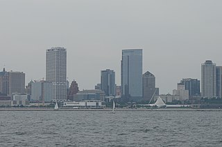
Downtown Milwaukee is the central business district of Milwaukee, Wisconsin. The economic and symbolic center of the city and the Milwaukee metropolitan area, it is Milwaukee's oldest district and home to many of region's cultural, financial educational and historical landmarks including Milwaukee City Hall, Fiserv Forum and the Milwaukee Art Museum. The city's modern history began in Downtown Milwaukee in 1795 when fur trader Jacques Vieau (1757–1852) built a post along a bluff on the east side, overlooking the Milwaukee and Menomonee rivers.

<span class="mw-page-title-main">George W. Stevens</span> American architect (1834–1897)

George W. Stevens was an American civil engineer and architect practicing in Manchester, New Hampshire, during the nineteenth century.

References

  1. "Master Plan".
  2. http://www.davidrumsey.com/rumsey/Size4/D0115/2023042.jpg?userid=15&username=lunaadmin&resolution=4&servertype=JVA&cid=8&iid=RUMSEY&vcid=NA&usergroup=Rumsey3x&profileid=13 [ bare URL image file ]
  3. "City of Manchester : Current Projects". Archived from the original on August 18, 2010. Retrieved July 31, 2010.
  4. "Oh Goodies: Wal-Mart Goes Mail-Order Gourmet".
  5. "Only In Print: Big-dollar facelift is hoped for the Hollow | New Hampshire Only in Print". www.unionleader.com. Archived from the original on June 30, 2014.
  6. "Mapping America: Every City, Every Block". The New York Times. December 13, 2010.