
Airdrie is a town in North Lanarkshire, Scotland. It lies on a plateau roughly 400 ft above sea level, and is approximately 12 miles (19 km) east of Glasgow city centre. As of 2012, the town had a population of around 37,130. Historically part of Lanarkshire, Airdrie forms part of a conurbation with its neighbour Coatbridge, in what is commonly known as the Monklands, formerly a district..

North Lanarkshire is one of 32 council areas of Scotland. It borders the northeast of the City of Glasgow and contains many of Glasgow's suburbs and commuter towns and villages. It also borders East Dunbartonshire, Falkirk, Stirling, South Lanarkshire and West Lothian. The council covers parts of the traditional counties of Dunbartonshire, Lanarkshire and Stirlingshire.

Lanarkshire, also called the County of Lanark, is a historic county, lieutenancy area and registration county in the central Lowlands of Scotland.

Coatbridge is a town in North Lanarkshire, Scotland, about 8+1⁄2 miles east of Glasgow city centre, set in the central Lowlands. Along with neighbouring town Airdrie, Coatbridge forms the area known as the Monklands, often considered to be part of the Greater Glasgow urban area – although officially they have not been included in population figures since 2016 due to small gaps between the Monklands and Glasgow built-up areas.

Bargeddie is a village in North Lanarkshire, Scotland, just inside the suburban fringe of Glasgow, 8 miles (13 km) east of the city centre, and close to the junction of the M73 and M8 motorways. The nearest major town is Coatbridge, 2 miles (3 km) to the east.

The Monkland Canal was a 12+1⁄4-mile-long (19.7 km) canal designed to bring coal from the mining areas of Monklands to Glasgow in Scotland. In the course of a long and difficult construction process, it was opened progressively as short sections were completed, from 1771. It reached Gartcraig in 1782, and in 1794 it reached its full originally planned extent, from pits at Calderbank to a basin at Townhead in Glasgow; at first this was in two sections with a 96-foot (29 m) vertical interval between them at Blackhill; coal was unloaded and carted to the lower section and loaded onto a fresh barge. Locks were later constructed linking the two sections, and the canal was also connected to the Forth and Clyde Canal, giving additional business potential.
The Garnkirk and Glasgow Railway was an early railway built primarily to carry coal to Glasgow and other markets from the Monkland coalfields, shortening the journey and bypassing the monopolistic charges of the Monkland Canal; passenger traffic also developed early in the line's existence.
The Monkland and Kirkintilloch Railway was an early mineral railway running from a colliery at Monklands to the Forth and Clyde Canal at Kirkintilloch, Scotland. It was the first railway to use a rail ferry, the first public railway in Scotland, and the first in Scotland to use locomotive power successfully, and it was a major influence in the successful development of the Lanarkshire iron industry. It opened in 1826.
The Wishaw and Coltness Railway was an early Scottish mineral railway. It ran for approximately 11 miles from Chapel Colliery, at Newmains in North Lanarkshire connecting to the Monkland and Kirkintilloch Railway near Whifflet, giving a means of transport for minerals around Newmains to market in Glasgow and Edinburgh.
The Monkland Railways was a railway company formed in 1848 by the merger of three "coal railways" that had been built to serve coal and iron pits around Airdrie in Central Scotland, and connect them to canals for onward transport of the minerals. The newly formed company had a network stretching from Kirkintilloch to Causewayend, near Linlithgow. These coal railways had had mixed fortunes; the discovery of blackband ironstone and the development of the iron smelting industry around Coatbridge had led to phenomenal success, but hoped-for mineral discoveries in the moorland around Slamannan had been disappointing. The pioneering nature of the railways left them with a legacy of obsolete track and locomotives, and new, more modern, railways were being built around them.
The Rutherglen and Coatbridge Railway was a railway line in Scotland built by the Caledonian Railway to shorten the route from the Coatbridge area to Glasgow. It opened in 1865. It was later extended to Airdrie in 1886, competing with the rival North British Railway. Soon after a further extension was built from Airdrie to Calderbank and Newhouse.
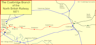
The Coatbridge Branch of the North British Railway was a railway built to connect the important coal and iron industrial districts of Coatbridge and Airdrie directly to Glasgow for the North British Railway.

Summerlee Museum of Scottish Industrial Life is an industrial and social history museum in Coatbridge, North Lanarkshire, Scotland. It is situated on the site of the Victorian Summerlee Iron Works and the former Hydrocon Crane factory. The main Hydrocon factory building became the museum’s exhibition hall but it has been substantially changed and adapted since. The museum aims to show Lanarkshire's contribution to engineering, mining, steel working, weaving and farming, and also show the lives of the people of the area. It includes interactive displays and a temporary exhibition space. Entry is free of charge.
The history of Coatbridge, Scotland, is one of dramatic change. The town transformed from an obscure group of 18th century Lanarkshire hamlets strung out on the road between Glasgow and Airdrie to a world leading centre of iron production in the 19th century. Development took off at an incredible rate in the 19th century and led to massive changes to the landscape and an explosion in the population.
Though Coatbridge is a most interesting seat of industry, it is anything but beautiful. Dense clouds of smoke roll over it incessantly, and impart to all the buildings a peculiarly dingy aspect. A coat of black dust overlies everything, and in a few hours the visitor finds his complexion considerably deteriorated by the flakes of soot which fill the air, and settle on his face. To experience Coatbridge it must be visited at night when it presents a most extraordinary spectacle.... From the steeple of the parish church the flames of no fewer than fifty blast furnaces may be seen.... The flames have a positively fascinating effect. Now they shoot far upward, and breaking off short, expire among the smoke; again spreading outward, they curl over the lips of the furnace, and dart through the doorways, as if determined to annihilate the bounds within which they are confined; then they sink low into the crater, and come forth with renewed strength in the shape of great tongues of fire, which sway backward and forward, as if seeking with a fierce eagerness something to devour. The Scotsman, 1869

Drumpellier Country Park is a country park situated to the west of Coatbridge, North Lanarkshire, Scotland. The park was formerly a private estate. The land was given over to the Burgh of Coatbridge for use as a public park in 1919, and was designated as a country park in 1984 by the then Monklands council, part of Strathclyde. The park covers an area of 500 acres (2.0 km2) and comprises two natural lochs, lowland heath, mixed woodlands and open grassland. The Monkland Canal lies towards the southern perimeter of the park. The lochs and the canal attract many water birds, both resident and over-wintering migrants, and the loch shores and woodland floor provides an abundance of wild flora. The woodlands are also rich in bird life, small wild animals and many types of fungi.
James Davidson, JP FRIBA was a Scottish architect. He also served as a Provost of Coatbridge and a President of Airdrie Savings Bank.

Broomhouse is a residential area in Glasgow, Scotland. It is about 6 miles (10 km) east of the city centre. Historically a small mining village and later the site of the Glasgow Zoo, in the early 21st century it grew substantially as an affluent commuter suburb.

Coatbridge North is one of the twenty-one wards used to elect members of the North Lanarkshire Council. It elects four councillors. Covering neighbourhoods in the north of Coatbridge, the ward had a population of 15,146 in 2019.

Coatbridge West is one of the twenty-one wards used to elect members of the North Lanarkshire Council. Covering neighbourhoods in the south-west of Coatbridge and the separate village of Bargeddie, it elects three councillors. A boundary review in 2017 caused the loss of an area between Langloan Street, the A725 and the A89, with a small decrease in the electorate but no change in the number of seats. The ward had a population of 14,910 in 2019.

