
Mangalore, officially known as Mangaluru, is a major industrial port city in the Indian state of Karnataka and on the west coast of India. It is located between the Laccadive Sea and the Western Ghats about 352 km (219 mi) west of Bangalore, the state capital, 14 km north of Karnataka–Kerala border and 297 km south of Goa. Mangalore is the state's only city to have all four modes of transport—air, road, rail and sea. The population of the urban agglomeration was 619,664 according to the 2011 national census of India. It is known for being one of the locations of the Indian strategic petroleum reserves.

Chennai Port, formerly known as Madras Port, is the second largest container port of India, behind Mumbai's Jawaharlal Nehru Port also known as Nhava Sheva. The port is the largest one in the Bay of Bengal. It is the third-oldest port among the 13 major ports of India with official port operations beginning in 1881, although maritime trade started much earlier in 1639 on the undeveloped shore. It is an artificial and all-weather port with wet docks. Once a major travel port, it became a major container port in the post-Independence era. An established port of trade of British India since the 1600s, the port remains a primary reason for the economic growth of Tamil Nadu, especially for the manufacturing boom in South India, and has contributed greatly to the development of the city of Chennai. It is due to the existence of the port that the city of Chennai eventually became known as the Gateway of South India.
Kamarajar Port, formerly Ennore Port, is located on the Coromandel Coast, Chennai about 18 km north of Chennai Port. It is the 12th major port of India, and the first port in India which is a public company. The Kamarajar Port Limited is the only corporatised major port and is registered as a company. Chennai Port Trust acquired around 67% stake of Centre in the Kamarajar Port Limited on 27 March 2020. The remaining 23 percent was already held by the Chennai Port Trust.
Surathkal is one of the major localities in the northern part of Mangalore city located on National highway 66 in the Dakshina Kannada district, Karnataka state, India on the shore of Arabian sea. It is a municipality merged with Mangalore City Corporation. It lies between Gurupura (Phalguni) and Pavanje (Nandini) rivers. It is the northern suburb and can be considered as the northernmost area of Mangalore City until Mukka. Surathkal has a railway station on Konkan railway route which connects cities of Mumbai to Mangaluru. Surathkal is 8 km north of New Mangalore seaport, 4 km west of Mangalore Refinery and Petrochemicals Limited and 16 km west of Mangalore International Airport This region has developed educationally, industrially and commercially can be regarded as one of the crucial localities in Mangaluru and coastal Karnataka. The only NIT of Karnataka is situated here which is adjacent to the national highway NH 66. Mukka a popular name in Indian surfing is also situated close to Surathkal. Surathkal beach is well known for its cleanliness and well maintained like other beaches in Mangalore.

Jawaharlal Nehru Port, also known as JNPT and Nhava Sheva Port, is the second largest container port in India after Mundra Port. Operated by the Jawaharlal Nehru Port Trust Authority (JNPTA), it is located on the eastern shores of Arabian Sea in Navi Mumbai, Raigad district, Maharashtra. This port can be accessed via Thane Creek, a nodal city of Navi Mumbai. It is the main port of the Mumbai Metropolitan Region after Mumbai Port, also of Maharashtra and Western India. Its common name derives from the names of Nhava and Sheva villages that are situated here. It is also the terminal of the Western Dedicated Freight Corridor.

Kadri Park is a park located in Kadri Gudde. It is the largest park in Mangalore. This park contains a musical fountain and has hosted the Karavali Utsav. The park is famous for flower shows in Mangalore.
Katipalla is a small town, five km from Surathkal in the Dakshina Kannada district of Karnataka state, India. Residents primarily speak Tulu, while Muslims in Katipalla often speak Byari.
The Port of Montreal is a cruise and transshipment point. It is located on the St. Lawrence River in Montreal, Québec, Canada. The port operates as an international container port. It services Toronto, the rest of Central Canada, the Midwestern United States, and the Northeastern United States. Though found on the Saint Lawrence Seaway, it is some 1,600 miles (2,600 km) inland from the Atlantic Ocean and it is on the shortest direct route between the North American Midwest and Europe or the Mediterranean.
Kochi is a major port city in the Indian state of Kerala. The city is widely known as the commercial or economic capital of the state of Kerala.
Panambur is one of the localities in Mangalore famous as a tourist spot. It is also a major industrial area and the site of Karnataka's main port, New Mangalore Port. Major industrial plants, such as Mangalore Chemicals & Fertilizers and KIOCL, are located here. Panambur lies north of the Gurupura River's confluence with the Arabian Sea about 10 kilometres (6.2 mi) north of Mangalore city centre, Dakshina Kannada district of Karnataka state, India. Panambur along with Baikampady and Jokatte are the main industrial areas of Mangalore and one of the major industrial areas of Karnataka.
Karnataka's coastline called Karavali stretches 300 km between Mangalore in Dakshina Kannada district and Karwar in Uttara Kannada district. The coastline of Karnataka has been along the eastern shore of Arabian Sea. Karnataka has one major and ten minor ports in this coastal belt. Kali, Belekeri, Gangavali, Aghanashini Sharavathi, Sharabi, Kollur, Gangolli, Sitanadi, Gurpur and Netravati are the important rivers in this belt which empty into the Arabian sea. Sea erosion, migration of river mouths, siltation of ports and harbours are some of the problems common to this belt.
Mangalore's location in the Indian state of Karnataka makes it accessible by all forms of transport: road, rail, air and sea. It is the largest city in the Coastal Karnataka region, and is the only city in Karnataka and one among the six cities in India to have an International Airport, a Major Seaport, railway & road connectivities. It is the second prominent city of Karnataka after the state capital Bangalore in all aspects. It is one of the fastest developing cities in India.

V. O. Chidambaranar Port is a port in Thoothukudi, Tamil Nadu, and is one of the 12 major ports in India. It was declared to be a major port on 11 July 1974. It is the second largest port in Tamil Nadu and third largest container terminal in India. V.O. Chidambaranar Port is an artificial port. This is the third international port in Tamil Nadu and it is second all-weather port. All V.O. Chidambaranar Port Authority's traffic handling has crossed 10 million tons from 1 April to 13 September 2008, registering a growth rate of 12.08 per cent, surpassing the corresponding previous year handling of 8.96 million tons. It has services to USA, China, Europe, Sri Lanka and Mediterranean countries. The Station Commander, Coast Guard Station Thoothukudi is located at V.O. Chidambaranar Port Authority, Tamil Nadu under the operational and administrative control of the Commander, Coast Guard Region (East), Chennai. The Coast Guard Station V.O. Chidambaranar Port Authority was commissioned on 25 April 1991 by Vice Admiral SW Lakhar, NM, VSM the then Director General Coast Guard. The Station Commander is responsible for Coast Guard operations in this area of jurisdiction in Gulf of Mannar. V.O. Chidambaranar Port Authority Thoothukudi is an ISO 9001:2008, ISO 14001:2004 and International Ship and Port Facility Security (ISPS) Code compliant port.

The Port of Cork is the main port serving the south of Ireland, County Cork and Cork City. It is one of the three "Ports of National Significance " as designated by National Ports Policy.

Ullal Beach is situated on the southwestern seaboard of the Indian sub-continent, adjacent to Ullal town, 10 km south of the city of Mangalore, Karnataka, India. Attractions are its picturesque stretch of Coconut trees, fishermen's lane, the ruined fort of Abbakka Devi and 16th century Jain temples. A resort is also situated nearby.
National Highway 66, commonly referred to as NH 66, is a mostly 4 lane 1640 km long busy National Highway that runs roughly north–south along the western coast of India, parallel to the Western Ghats. It connects Panvel, a city east of Mumbai to Cape Comorin (Kanyakumari), passing through the states of Maharashtra, Goa, Karnataka, Kerala and Tamil Nadu.
Panambur Beach is a beach on the shores of the Arabian Sea in the city of Mangalore in the Indian state of Karnataka.

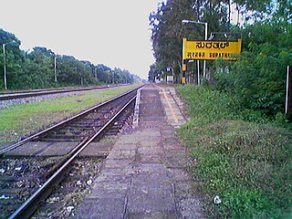
Surathkal railway station is one of the main railway stations of Mangalore city along with Mangalore Central railway station and Mangalore Junction railway station and is located in north Mangaluru on Konkan Railway route. Twenty-two trains stop here.KRCL operates RO-RO services from Suratkal to Verna, Kolad, and Karembeli. As per the Konkan railway map, Surathkal railway station is at a distance of 733.825 kilometers from the northern starting point of the Konkan railway line at Roha and 4.615 kilometers from Thokur which is the southern endpoint of Konkan railway jurisdiction. The Surathkal railway station is at distance of 26.285 Kilometre from Mangaluru Central(MAQ) railway station.

NITK Beach also known as Surathkal beach is on the Arabian Sea coast at Surathkal, 16 km (9.9 mi) north of the centre of Mangalore city, in the Dakshina Kannada district of Karnataka, India. It is a private beach that was later named after the nearby NITK.
Sasihithlu beach also known as Daibittil beach is located in Sasihithlu village, which is situated north of Mangalore city, in the state of Karnataka, in India. Sasihithlu Beach is situated approximately 6 km to the west of NH 66, and surrounded by the backwaters of the Pavanje and Shambhavi rivers. The two rivers meet at the beach. It is close to Mukka, one of the fastest developing localities of Mangalore. This beach hosted the Indian Open of Surfing in 2016 and 2017.

