
The New Jersey Turnpike (NJTP) is a system of controlled-access highways in the U.S. state of New Jersey. The turnpike is maintained by the New Jersey Turnpike Authority (NJTA). The 117.20-mile (188.62 km) mainline's southern terminus is at a complex interchange with Interstate 295 (I-295), U.S. Route 40 (US 40), US 130, and Route 49 near the border of Pennsville and Carneys Point townships in Salem County, one mile (1.6 km) east of the Delaware Memorial Bridge. Its northern terminus is at an interchange with I-80 and US 46 in Ridgefield Park. Construction of the mainline from concept to completion took 22 months, from 1950 to 1951. It was opened to traffic on November 5, 1951, between its southern terminus and exit 10.

The Garden State Parkway (GSP) is a controlled-access toll road that stretches the north–south length of eastern New Jersey from the state's southernmost tip near Cape May north to the New York state line at Montvale. Its name refers to New Jersey's nickname, the "Garden State". The parkway has an unsigned reference number of Route 444 by the New Jersey Department of Transportation (NJDOT). At its north end, the road becomes the Garden State Parkway Connector, a component of the New York State Thruway system that connects to the Thruway mainline in Ramapo.

New York State Route 17 (NY 17) is a major state highway that extends for 397 miles (638.91 km) through the Southern Tier and Downstate regions of New York in the United States. It begins at the Pennsylvania state line in Mina and follows the Southern Tier Expressway east through Corning to Binghamton and the Quickway from Binghamton east to Woodbury, where it turns south to follow the Orange Turnpike to the New Jersey state line near Suffern, where it connects to New Jersey Route 17. From the Pennsylvania border to the village of Waverly and from Binghamton to Windsor, NY 17 is concurrent with Interstate 86 (I-86). Eventually, the entire east–west portion of NY 17 from the Pennsylvania border to Woodbury will become I-86 as projects to upgrade the route to Interstate Highway standards are completed.
E-ZPass is an electronic toll collection system used on toll roads, toll bridges, and toll tunnels in the Eastern United States, Midwestern United States, and Southern United States. The E-ZPass Interagency Group (IAG) consists of member agencies in several states, which use the same technology and allow travelers to use the same transponder on toll roads throughout the network.
The New York State Thruway is a system of controlled-access toll roads spanning 569.83 miles (917.05 km) within the U.S. state of New York. It is operated by the New York State Thruway Authority (NYSTA), a New York State public-benefit corporation. The 496.00-mile (798.23 km) mainline is a freeway that extends from the New York City line at Yonkers to the Pennsylvania state line at Ripley by way of I-87 and I-90 through Albany, Syracuse, and Buffalo. According to the International Bridge, Tunnel and Turnpike Association, the Thruway is the fifth-busiest toll road in the United States. The toll road is also a major route for long distance travelers linking the cities of Toronto and Buffalo with Boston and New York City.
New York State Route 32 (NY 32) is a north–south state highway that extends for 176.73 miles (284.42 km) through the Hudson Valley and Capital District regions of the U.S. state of New York. It is a two-lane surface road for nearly its entire length, with few divided and no expressway sections. From Harriman to Albany, it is closely parallel to Interstate 87 (I-87) and U.S. Route 9W (US 9W), overlapping with the latter in several places.
Interstate 287 (I-287) is an auxiliary Interstate Highway in the US states of New Jersey and New York. It is a partial beltway around New York City, serving northern New Jersey and the counties of Rockland and Westchester in New York. I-287, which is signed north–south in New Jersey and east–west in New York, follows a roughly horseshoe-shaped route from the New Jersey Turnpike (I-95) in Edison, New Jersey, clockwise to the New England Thruway (I-95) in Rye, New York, for 98.72 miles (158.87 km). Through New Jersey, I-287 runs west from its southern terminus in Edison through suburban areas. In Bridgewater Township, the freeway takes a more northeasterly course, paralleled by US Route 202 (US 202). The northernmost part of I-287 in New Jersey passes through mountainous surroundings. After crossing into New York at Suffern, I-287 turns east on the New York State Thruway (I-87) and runs through Rockland County. After crossing the Hudson River on the Tappan Zee Bridge, I-287 splits from I-87 near Tarrytown and continues east through Westchester County on the Cross-Westchester Expressway until it reaches the New England Thruway. Within New Jersey, I-287 is maintained by the New Jersey Department of Transportation (NJDOT), and, within New York, it is maintained by the New York State Thruway Authority (NYSTA).

The New York State Police (NYSP) is the state police of the U.S. state of New York; it is part of the New York State Executive Department and employs over 5,000 sworn state troopers and 711 non-sworn members.

Interstate 84 (I-84) is an Interstate Highway in the Northeastern United States that extends from Dunmore, Pennsylvania, near Scranton at an interchange with I-81 east to Sturbridge, Massachusetts, at an interchange with the Massachusetts Turnpike (I-90). Among the major cities that the road passes through is Hartford, Connecticut, and the road provides a major portion of the primary route between New York City and Boston. Another highway named I-84 is located in the Northwestern United States.

Interstate 86 (I-86) is an Interstate Highway that extends for 223.39 miles (359.51 km) through northwestern Pennsylvania and the Southern Tier region of New York, in the United States. The highway has two segments: the longer of the two begins at an interchange with I-90 east of Erie, Pennsylvania, and ends just beyond the Chemung-Tioga county line at the Pennsylvania border, while the second extends from I-81 east of Binghamton to New York State Route 79 (NY 79) in Windsor. When projects to upgrade the existing NY 17 to Interstate Highway standards are completed, I-86 will extend from I-90 near Erie to the New York State Thruway (I-87) in Woodbury. The portion in Erie County, Pennsylvania, is known as the Hopkins-Bowser Highway and is signed as such at each end. In New York, the current and future alignment of I-86 is known as the Southern Tier Expressway west of I-81 in Binghamton and the Quickway east of I-81.
Interstate 190 is a north–south auxiliary Interstate Highway in the United States that connects I-90 in Buffalo, New York, with the Canada–United States border at Lewiston, New York, near Niagara Falls. Officially, I-190 from I-90 north to New York State Route 384 (NY 384) is named the Niagara Thruway and is part of the New York State Thruway system. The remainder, from NY 384 to Lewiston, is known as the Niagara Expressway and is maintained by the New York State Department of Transportation (NYSDOT).
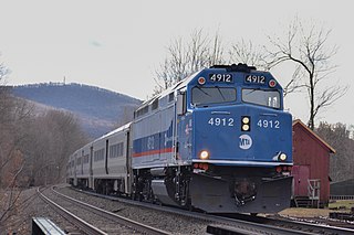
The Port Jervis Line is a predominantly single-track commuter rail line running between Suffern and Port Jervis, in the U.S. state of New York. At Suffern, the line continues south into New Jersey on NJ Transit's Main Line. The line is operated by NJ Transit Rail Operations under a contract with Metro-North Railroad (MNRR).

New York State Route 300 (NY 300) is a state highway located west of the city of Newburgh in the Hudson Valley of New York in the United States. The southern terminus of the route is at a five-way intersection with NY 32 and NY 94 in the hamlet of Vails Gate. From there, it runs generally northwesterly through the towns of New Windsor, Newburgh, and Shawangunk, to a junction with NY 208 near the hamlet of Wallkill. NY 300's two major changes of direction are marked by slightly unorthodox intersections with other state highways.

The Castleton Bridge is a cantilever truss bridge over the Hudson River, connecting Coeymans, Albany County with Schodack, Rensselaer County in New York. It carries the Berkshire Connector of the New York State Thruway. This bridge is also sometimes called the Castleton-on-Hudson Bridge and is situated in close proximity to the Alfred H. Smith Memorial Bridge, which is used by rail traffic.

Interstate 95 (I-95) is part of the Interstate Highway System and runs from Miami, Florida, to the Canada–United States border near Houlton, Maine. In the US state of New York, I-95 extends 23.50 miles (37.82 km) from the George Washington Bridge in New York City to the Connecticut state line at Port Chester. The George Washington Bridge carries I-95 across the Hudson River from New Jersey into New York City. There, I-95 runs across Upper Manhattan on the Trans-Manhattan Expressway for 0.81 miles (1.30 km) through Washington Heights. It continues east across the Harlem River on the Alexander Hamilton Bridge and onto the Cross Bronx Expressway. In the Bronx, I-95 leaves the Cross Bronx at the Bruckner Interchange, joining the Bruckner Expressway to its end. North of the interchange with Pelham Parkway, it then continues northeast via the New England Thruway out of New York City into Westchester County and to the Connecticut state line, where I-95 continues on the Connecticut Turnpike.

New York State Route 17K (NY 17K) is an east–west state highway located within Orange County, New York, in the United States. It extends for 22.01 miles (35.42 km) from an intersection with NY 17 east of Bloomingburg to a junction with U.S. Route 9W (US 9W) midway across the city of Newburgh. The western terminus was where NY 17K originally connected to its parent route, NY 17; it now meets NY 17 a short distance to the east at an interchange with the Quickway. In Newburgh, NY 17K becomes Broadway and serves as the city's primary east–west street. The road can be divided into a half west of Montgomery, where it runs through relatively undeveloped land, and an eastern half where it closely parallels Interstate 84 (I-84) and serves much more populated areas.

The Delaware River–Turnpike Toll Bridge is a four-lane, steel through arch bridge crossing the Delaware River between Burlington Township, Burlington County, New Jersey and Bristol Township, Bucks County, Pennsylvania. As a part of Interstate 95 (I-95), it is a major highway link between Philadelphia and New York City. The bridge also connects the Pennsylvania Turnpike's east-west mainline with the main trunk of the New Jersey Turnpike, via the Pearl Harbor Memorial Turnpike Extension. Tolls are collected only in the west/southbound direction via electronic toll collection.
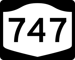
New York State Route 747 (NY 747) is a state highway in northeast Orange County, New York, in the United States. The route extends for about 3.5 miles (5.6 km) from NY 207 in the town of New Windsor to NY 17K in the town of Montgomery. It officially came into existence when exit 32 on Interstate 84 was completed and opened in 2007. Most of NY 747 follows Drury Lane, once a highway maintained by Orange County as County Route 54.

Interstate 90 (I-90) is a part of the Interstate Highway System that runs from Seattle, Washington, to Boston, Massachusetts. In the US state of New York, I-90 extends 385.48 miles (620.37 km) from the Pennsylvania state line at Ripley to the Massachusetts state line at Canaan, and is the second-longest highway in the state after New York State Route 17 (NY 17). Although most of the route is part of the tolled New York State Thruway, two non-tolled sections exist along I-90. Within New York, I-90 has a complete set of auxiliary Interstates, which means that there are Interstates numbered I-190 through I-990 in the state, with no gaps in between. For most of its length in New York, I-90 runs parallel to the former Erie Canal route, NY 5, US Route 20 (US 20) and the CSX Transportation railroad mainline that traverses the state.
Interstate 84 (I-84) is a part of the Interstate Highway System that runs from Dunmore, Pennsylvania, to Sturbridge, Massachusetts, in the eastern United States. In New York, I-84 extends 71.46 miles (115.00 km) from the Pennsylvania state line at Port Jervis to the Connecticut state line east of Brewster. As it heads east–west across the mid Hudson Valley, it goes over two mountain ranges and crosses the Hudson River at the Newburgh–Beacon Bridge.


