North Wessex Downs

Last updated

North Wessex Downs National Landscape
View of Ambley Wood south of Upton - geograph.org.uk - 23051.jpg
This is a typical view of the chalk North Wessex Downs in the north west part of Hampshire
North Wessex Downs AONB locator map.svg
Location of the North Wessex Downs AONB in the UK
LocationEngland
Designated1972

The North Wessex Downs National Landscape (until November 2023 an Area of Outstanding Natural Beauty or AONB) is located in the English counties of Berkshire, Hampshire, Oxfordshire and Wiltshire. [1] [2] The name North Wessex Downs is not a traditional one, the area covered being better known by various overlapping local names, including the Berkshire Downs, the North Hampshire Downs, the White Horse Hills, the Lambourn Downs, the Marlborough Downs, the Vale of Pewsey and Savernake Forest.

Contents

Topography

The AONB covers an area of some 1,730 km2 (670 sq mi). It takes the form of a horseshoe, with the open end facing east, surrounding the town of Newbury and the River Kennet catchment area. The northern arm reaches as far east as the suburbs of Reading in mid-Berkshire and as far north as Didcot in South Oxfordshire, whilst the southern arm extends to Basingstoke in northern Hampshire. To the west, the AONB reaches as far as Calne and Devizes. The highest points are the 297 m (974 ft) summit of Walbury Hill, situated southeast of Hungerford in West Berkshire (and the highest point in southern England east of the Mendip Hills), and the Milk Hill-Tan Hill plateau northeast of Devizes in central Wiltshire, at 295 m (968 ft) above sea level.

The southwestern slopes of Walbury Hill The South Western Slopes of Walbury Hill - geograph.org.uk - 62332.jpg
The southwestern slopes of Walbury Hill

At its northeast extreme, Lardon Chase within the North Wessex Downs AONB faces across the Goring Gap to the Chilterns AONB on the other side of the River Thames. From here working anti-clockwise around the horseshoe, the Berkshire Downs have a steep scarp slope facing north over the Vale of White Horse and a gentler dip slope facing south into the valley of the Kennet. This area includes the horse-racing village of Lambourn and is hence sometimes known as the Lambourn Downs. Beyond the town of Marlborough the downs (now called the Marlborough Downs) sweep in a semicircle to the south around the headwaters of the River Kennet, with the Vale of Pewsey cutting through these downs carrying the headwaters of the Hampshire River Avon. Here too can be found the wooded area of Savernake Forest. Finally, the highest stretch of the Downs runs east along the Berkshire-Hampshire border on the opposite side of the River Kennet from the Berkshire Downs. Again the scarp slope is to the north (facing down in the valley of the Kennet) and the dip slope is to the south into Hampshire.

Geology and natural history

Uffington White Horse and Dragon Hill Uffington White Horse and Dragon Hill - geograph.org.uk - 238471.jpg
Uffington White Horse and Dragon Hill

The downland is part of the Southern England Chalk Formation which runs from Dorset in the west to Kent in the east and also includes the Dorset Downs, Purbeck Hills, Cranborne Chase, Wiltshire Downs, Salisbury Plain, the Isle of Wight, Chiltern Hills and the North and South Downs.

The area is a site of scientific interest in numerous fields and has an internationally important habitat for early gentian. Geologically, its chalk downs, dry valleys and sarsen outcrops are of note, the last in the area around Marlborough providing material for many of the Neolithic and Bronze Age sites in the area such as Avebury Henge.

Economy

Horse racing forms a major industry in the area, largely because of the good quality turf that comes with the chalk underlay, and much of upland area is made over to gallops and other training areas. Several of the upland villages, and especially the large village of Lambourn, are home to major racing stables. Other villages with strong horse racing connections include Beckhampton, Kingsclere and West Ilsley. The term steeplechase originated in this area,[ citation needed ] a steeplechase originally being a race between two villages, navigated by reference to the church steeples visible across the rolling downs.

Literature

Watership Down, taken from the north-east Watership from northeast.jpg
Watership Down, taken from the north-east

On the south-east arm of the AONB can be found Watership Down where the book Watership Down by Richard Adams is set, to the north of the small market town of Whitchurch, Hampshire.

Significant parts of Jude the Obscure by Thomas Hardy are set on and in the villages connected to the Berkshire Downs.

AONB Council of Partners

The Area of Outstanding Natural Beauty was designated in 1972. It is managed by a Council of Partners whose members are:

Related Research Articles

<span class="mw-page-title-main">Wiltshire</span> County of England

Wiltshire is a ceremonial county in South West England. It borders Gloucestershire to the north, Oxfordshire to the north-east, Berkshire to the east, Hampshire to the south-east, Dorset to the south, and Somerset to the west. The largest settlement is Swindon, and Trowbridge is the county town.

<span class="mw-page-title-main">Oxfordshire</span> County of England

Oxfordshire is a ceremonial county in South East England. The county is bordered by Northamptonshire and Warwickshire to the north, Buckinghamshire to the east, Berkshire to the south, and Wiltshire and Gloucestershire to the west. The city of Oxford is the largest settlement and county town.

<span class="mw-page-title-main">Berkshire</span> County of England

The Royal County of Berkshire, commonly known as simply Berkshire, is a ceremonial county in South East England. It is bordered by Oxfordshire to the north, Buckinghamshire to the north-east, Greater London to the east, Surrey to the south-east, Hampshire to the south, and Wiltshire to the west. Reading is the largest settlement and the county town.

<span class="mw-page-title-main">Downland</span> Area of open chalk hills

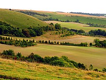
Downland, chalkland, chalk downs or just downs are areas of open chalk hills, such as the North Downs. This term is used to describe the characteristic landscape in southern England where chalk is exposed at the surface. The name "downs" is derived from the Old English word dun, meaning "hill".

<span class="mw-page-title-main">River Kennet</span> Tributary of the River Thames in Southern England

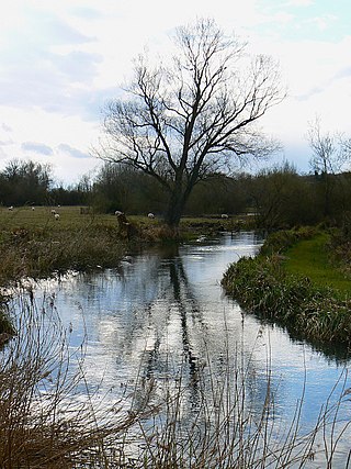
The Kennet is a tributary of the River Thames in Southern England. Most of the river is straddled by the North Wessex Downs AONB. The lower reaches have been made navigable as the Kennet Navigation, which – together with the Avon Navigation, the Kennet and Avon Canal and the Thames – links the cities of Bristol and London.

<span class="mw-page-title-main">West Berkshire</span> Unitary area in the county of Berkshire,England

West Berkshire is a unitary authority area in the ceremonial county of Berkshire, England. It is administered from Newbury by West Berkshire Council.

<span class="mw-page-title-main">South Downs</span> Range of chalk hills in southeast England

The South Downs are a range of chalk hills in the south-eastern coastal counties of England that extends for about 260 sq mi (670 km2) across the south-eastern coastal counties of England from the Itchen valley of Hampshire in the west to Beachy Head, in the Eastbourne Downland Estate, East Sussex, in the east. The Downs are bounded on the northern side by a steep escarpment, from whose crest there are extensive views northwards across the Weald. The South Downs National Park forms a much larger area than the chalk range of the South Downs, and includes large parts of the Weald.

<span class="mw-page-title-main">Hungerford</span> Town in England

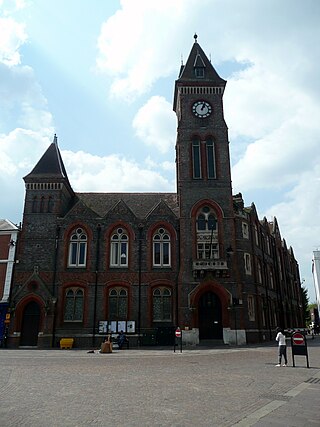
Hungerford is a historic market town and civil parish in Berkshire, England, 8 miles (13 km) west of Newbury, 9 miles (14 km) east of Marlborough, 27 miles (43 km) north-east of Salisbury and 60 miles (97 km) west of London. The Kennet and Avon Canal passes through the town alongside the River Dun, a major tributary of the River Kennet. The confluence with the Kennet is to the north of the centre whence canal and river both continue east. Amenities include schools, shops, cafés, restaurants, and facilities for the main national sports. Hungerford railway station is a minor stop on the Reading to Taunton Line.

<span class="mw-page-title-main">Vale of White Horse</span> Non-metropolitan district in England

The Vale of White Horse is a local government district of Oxfordshire in England. It was historically part of Berkshire. The area is commonly referred to as the 'Vale of the White Horse'. It is crossed by the Ridgeway National Trail in its far south, across the North Wessex Downs AONB at the junction of four counties. The northern boundary is defined by the River Thames. The name refers to Uffington White Horse, a prehistoric hill figure.

<span class="mw-page-title-main">Vale of Pewsey</span> Vale in Wiltshire, England

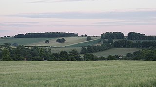
The Vale of Pewsey or Pewsey Vale is an area of Wiltshire, England to the east of Devizes and south of Marlborough, centred on the village of Pewsey.

<span class="mw-page-title-main">Pewsey</span> Village and civil parish in Wiltshire, England

Pewsey is a large village and civil parish at the centre of the Vale of Pewsey in Wiltshire, about 6 miles (10 km) south of Marlborough and 71 miles (114 km) west of London. It is within reach of the M4 motorway and the A303 and is served by Pewsey railway station on the Reading to Taunton line.

<span class="mw-page-title-main">River Lambourn</span> River in Berkshire, United Kingdom

The River Lambourn is a chalk stream in the English county of Berkshire. It rises in the Berkshire Downs near its namesake village of Lambourn and is a tributary of the River Kennet, which is itself a tributary of the River Thames.

<span class="mw-page-title-main">Berkshire Downs</span> Chalk hills in England

The Berkshire Downs are a range of chalk downland hills in southern England, part of the North Wessex Downs Area of Outstanding Natural Beauty. The Berkshire Downs are wholly within the traditional county of Berkshire, although split between the current ceremonial counties of Berkshire and Oxfordshire. The western parts of the downs are also known as the Lambourn Downs.

<span class="mw-page-title-main">Burbage, Wiltshire</span> Human settlement in England

Burbage is a village and civil parish in the Vale of Pewsey, Wiltshire, England. It is about 6 miles (9.7 km) south of Marlborough and 20 miles (32 km) west of Newbury.

<span class="mw-page-title-main">Grafton, Wiltshire</span> Human settlement in England

Grafton is a civil parish in Wiltshire, England, in the Vale of Pewsey about 7 miles (11 km) southeast of Marlborough. Its main settlement is the village of East Grafton, on the A338 Burbage - Hungerford road; the parish includes the village of Wilton and the hamlets of West Grafton, Marten and Wexcombe.

<span class="mw-page-title-main">Milton Lilbourne</span> Human settlement in England

Milton Lilbourne is a village and civil parish in the county of Wiltshire, England, in the Vale of Pewsey between Pewsey and Burbage. It is largely a mixed residential area centred on the Manor. The nearest town is Marlborough, 5.5 miles (8.9 km) to the north.

<span class="mw-page-title-main">London Basin</span> The basin of river Thames in London

The London Basin is an elongated, roughly triangular sedimentary basin approximately 250 kilometres (160 mi) long which underlies London and a large area of south east England, south eastern East Anglia and the adjacent North Sea. The basin formed as a result of compressional tectonics related to the Alpine orogeny during the Palaeogene period and was mainly active between 40 and 60 million years ago.

<span class="mw-page-title-main">Pewsey White Horse</span> Hill figure of a white horse in England

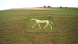
Pewsey White Horse is a hill figure of a white horse near the village of Pewsey, Wiltshire, England. Cut of chalk in 1937, it replaces an earlier horse that had disappeared under the grass and is one of eight remaining white horses in Wiltshire. It measures 66’ by 45’, making it the smallest of the eight canonical white horses in Wiltshire.

<span class="mw-page-title-main">Hampshire Downs</span>

The Hampshire Downs form a large area of downland in central southern England, mainly in the county of Hampshire but with parts in Berkshire and Wiltshire. They are part of a belt of chalk downland that extends from the South Downs in the southeast, north to the Berkshire and Marlborough Downs, and west to the Dorset Downs.

<span class="mw-page-title-main">Thames Basin Heaths</span>

The Thames Basin Heaths are a natural region in southern England in Berkshire, Hampshire and Surrey, a slightly mottled east-west belt of ecologically recognised and protected land.

References

  1. "About Us". North Wessex Downs National Landscape. Retrieved 3 February 2024.
  2. Davison, Steve. "10 Reasons to Visit the North Wessex Downs". Cicerone Press. Retrieved 3 February 2024.

Further reading

51°27′25″N1°30′29″W / 51.457°N 1.508°W / 51.457; -1.508