Northam is a town in the Wheatbelt region of Western Australia, situated at the confluence of the Avon and Mortlock Rivers. It is the largest town and regional centre in the Avon Valley region of the Central Wheatbelt. It is located approximately 97 kilometres (60 miles) north east of Perth, the capital city of Western Australia. At the time of the 2021 census, Northam had a population of 6,679.[3]
The area around Northam was first explored in 1830 by a party of colonists led by Ensign Robert Dale, and subsequently founded in 1833. It was named by Governor Stirling, probably after a village of the same name in Devon, England. Almost immediately it became a point of departure for explorers and settlers who were interested in the lands which lay to the east.
This initial importance declined with the growing importance of the nearby towns of York and Beverley, but the arrival of the railway made Northam the major departure point for prospectors and miners heading east towards the goldfields.
The Northam Migrant Accommodation Centre closed in September 1951. It had been the first place of residence in Western Australia for approximately 15,000 immigrants from the Baltic states, Hungary, Poland, Czechoslovakia, Italy, Yugoslavia, Ukraine, Belarus and Bulgaria.[7] During the peak immigration period, Northam had the largest immigrant receiving facilities within the State and the third largest in Australia.[8] By 1950, the camp housed 4,000 people and two new blocks of huts were built to accommodate them all.[9] By May 1954, 23,000 migrants had passed through the Northam Camp once the Accommodation Centre had closed. A significant number of these post-war arrivals eventually settled in the Northam area.
Yongah Hill Immigration Detention Centre
On 18 October 2010 the Yongah Hill (YHIDC) centre was announced as being established at the former Northam Army Training Camp.[10][11][12][13] It was not opened until early 2012, however, and, after it was downsized from the original 1500 expected occupancy, talk of expansion has been happening.
In September 2018 a riot broke out at the centre and some buildings were set on fire, after a detainee was reportedly found in his cell injured after a suicide attempt.[16] The detainee, who was a refugee, later died.[17]
Also in September 2018, a guard was alleged to have sexually assaulted a detainee.[14]
Geography
The town and hinterland of Northam are located in the Avon Valley - so named after the river the Avon River. It has been periodically flooded, and man-made banks protect the town from inundation. The Avon is a name commonly used by organisations, newspapers and sporting groups.
The river is spanned by a pedestrian suspension bridge; at 117 metres (384ft),[18] it is the longest such bridge in Australia.[19]
Burlong Pool a pool just south of the town was known as the Burlong swimming pool, and in the 1890s the location of the source of water for the Goldfields water trains.[20]
A severe thunderstorm lashed the town and surrounding areas on 27 January 2011 resulting in roofs being ripped off, trees being uprooted and power lines being brought down.[22] About 50 houses were damaged in the town as a result of the storm but no injuries were reported.[23]
2021
A flash flood occurred in the town and surrounding areas on 2 March 2021, with 40 millimetres of rainfall occurring in just half an hour. This resulted in many houses being damaged, as well as the Jubilee oval flooding, leaving silt all over the busy road of Peel Terrace.[24]
Government
Originally, the town and surrounding area was split into two municipalities, the Town of Northam handling the affairs of the town, and the Shire of Northam which also manages other towns, such as Bakers Hill and Wundowie. After 53 years of debates and failed attempts, the two councils finally merged as of the 1 July 2007 to form a conglomerate council, simply known as the Shire of Northam.
The public sector is a large employer for residents of Northam and surrounding areas. The town of Northam is the main regional centre for the Central Wheatbelt region, and as such many local and state government departments choose to operate out of the town.[25][26][27]
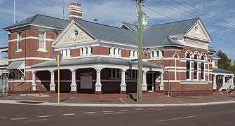
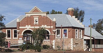
The original station on Fitzgerald Street was opened in 1900 and closed in 1966 when the new Eastern Railway route became operational.[30]
The layout of the pre-1966 narrow gauge railway also had a busy junction at East Northam; this was removed on the completion of the new standard gauge railway.[31]
Northam has three public primary schools, a public high school, and a TAFE campus. It also has a private Catholic school, St Josephs which conducts classes from Kindergarten to Year 12, across two campuses.
Primary School
The original Northam Primary School was established in 1890, making it one of the states oldest primary schools.[32] The current school opened in 1978 replacing the original structure, it is located on Duke Street. It was the first primary school of the area and has approximately over 300 students.[32] West Northam Primary School is located on Habgood Street and has approximately 140 students.[33] Avon Vale Primary School opened in 1954. It is located on Hutt Street and has approximately 140 students.
High School
Northam Senior High School is the public high school for the area. It is one of the oldest high schools in the state, opening in 1921. The main building is heritage listed, though the campus has had renovations and further additions added to it in 1986, 1996 and 2015[34][35] It has approximately 715 students. In Semester 2, 2020 the school became an Independent Public School.[36] It has several specialized programs to meet the diverse needs of its students, such as the Big Picture Program,[37]Clontarf Foundation, Wirrpanda Foundation, Deadly Sista Girlz and others. The school not only intakes students from the town of Northam, but also Year 10-12 students from the surrounding District High Schools, including the surrounding towns of Toodyay, York, Beverley, Goomalling and others. It also has a college for students that board that are from remote communities, Northam Residential College.[38]
Private Education
Saint Josephs is a private Catholic school, with two campuses in Northam. It has approximately 600 students and teaches from Kindergarten to Year 12. The primary school campus, located on Lance Street, teaches students Kindergarten to Year 6. The high school campus, located on Wellington Street East, teaches students Year 7 to Year 12. This campus was opened in 1889 by the Sisters of Saint Joseph of the Apparition, while the Marist Brothers opened the Saint Pauls school in 1948 and 1971 before merging the schools together.[39]
Tertiary Educaion
Northam has a TAFE campus, previously known as the C. Y. O'Connor Institute. It has since been merged with other regional TAFEs and trades under Central Regional TAFE.[40]
Northam is also home to the Muresk Institute, one of Western Australia's leading tertiary educators for agriculture.[41]
Sport
Association Football (Soccer) has been played in Northam since just after World War Two. Due to the many European immigrants living at the Holden Camp a league was formed comprising nine teams from Northam and one from Wundowie. Many of the teams were based on ethnicity such as: Italian; Dutch; Polish; Hungarian; Romanian; Yugoslav; Austrian; German and Bulgarian. In recent years, Northam United FC was a men's team whilst Northam Springfield FC is a children's football club in its tenth season (2021). Springfield play in the winter against their rivals Toodyay Junior Soccer Club.
Northam has some very committed sporting teams. Australian rules football is an obsession with many of the people of Western Australia. Northam has two teams that play in the Avon Football Association competition, Federals and Railways.
Field and indoor hockey, cricket, and netball also attract significant numbers of players and spectators. Individual sports such as tennis and cycling including BMX are also popular.
The BMX State Championships were held in Northam in 2003 with 3,000 competitors and spectators attending the event for over a week with Northam competitors showing their dominance in the sport in the state. Three local riders who participated in this event (Dale Reynolds - then ranked 3WA for 18 Men's, Chris Marris - then ranked 1WA for 18 Men's, and Kyle Martin - then ranked 4WA for 18 Men's) have subsequently completed cross country rides from Adelaide to Perth demonstrating the interest in cycling in Northam.
Steve Fossett became the first person to fly around the world alone, non-stop, in a hot air balloon when he launched from Northam on 19 June 2002, and returned to Australia on 3 July, landing in Queensland.[42]
In July 2016 Russian adventurer and balloon pilot Fedor Konyukhov took off from Northam airfield to attempt a solo nonstop round the world balloon flight. He completed his circumnavigation, covering 33,521 kilometres (20,829mi), in 11 days, 4 hours and 20 minutes, beating Fossett's record by 52 hours.[43]
Between 1952 and 1956 several motor racing events were held using streets within the town.[44] The first circuit used was on the south side of the Avon River, but this was considered too dangerous, so a new circuit was built in 1956 on the north side of the river.[45]
Thoroughbred horse racing is held at Northam Racecourse by the Northam Race Club.[46] The track held its first race in 1863 and has about 22 race meetings[47] during the year.
The town of Northam is home to several iconic Western Australian events and activities.
The Avon Descent is an annual, two-day white water river race that begins in Northam, and travels 124km down the Avon River, into the Swan River before finishing in Bayswater.[48] It occurs each year in August, and allows both power craft and peddle craft.
The Northam Motorsport Festival occurs annually between the months of March and April and is the spiritual successor to the historical Northam Flying 50s event.[49][50] It is a free event which incorporates three activities, the Mount Ommanney Hillclimb, the SCBC Motokhana and the iconic Northam Flying 50s, an event in which the main streets of Northam are used as a circuit in which classic cars may complete time trials and race. There also is a classic car show, and several other small promotions and specials put on by community members. The show attracts around 5,000 spectators annually.
The Northam Farmer's Show[51] is held annually on a Friday and Saturday in mid-September. It is an agricultural show similar to others held in the area, such as the York Show and the Toodyay Show.[52][53]
The Kep Ultra running race is held each year on the Western Australia Day long weekend in early June. The race starts in Northam and includes 100km and 75km events finishing at Mundaring Weir.[54][55]
Military history
During World War I, Wilberforce, an area on the Spencers Brook to York Road was the area set up for the breeding and selection of horses to be transported to overseas theatres of war involving Australian horseman in particular the iconic 10th Light Horse Regiment.[56]
Also in November 1920, an area at Noggojerrring was purchased by the Federal Government for £7,000. It was an area of 875 acres(350 hectares) of farming land and was located four miles (6.5 kilometres) north of Northam on the Northam - Pithara Road. Of that area, 860 acres (344 hectares) were cleared and divided into 11 paddocks. The property was well watered, and carried a wind mill, two dwellings, three sheds, and a stable. The Goomalling railway bisected it. The Federal Government's purpose was the settlement of tubercular soldiers. The place was christened Anzac Farm.[57]
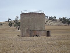
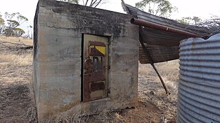
During World War II, Northam was the location of a number of important strategic military camps, depots and installations being the most concentrated of military activity areas in Western Australia. Due to its strategic geographical location and being close to water, the Goldfields Water Supply Scheme, close to strategic railway junction,[58] as it was close to the coast but inland, Northam became an important military hub.
The installations, camps, and depots were some of those developed in the Wheatbelt during 1939–1945, located within the Shire of Northam, some of which still exist today.
Northam Army Camp including the 38th Camp Hospital, training and hospital
6 Commonwealth Ammunition Depot (6CAD) to become 51 Supply Company, Springhill, ammunition storage
US Navy 7 Naval Ammunition Depot (7 NAD), Springhill,[59] torpedo storage
↑ Peters, Nonja; Bush, Fiona; Gregory, Jenny (Jennifer Anne); Australian Heritage Commission; University of Western Australia. Centre for Western Australian History; Heritage Council of Western Australia (1993), The Holden Immigration Camp, Northam, Centre for Western Australian History; [East Perth, W.A.: distributed by the Heritage Council], retrieved 1 April 2013
↑ "Northam Show Will Be Bigger, Better". The Beverley Times. Vol.2, no.54. Western Australia. 29 August 1963. p.11 (A DISTRICT NEWS SUPPLEMENT PREPARED FOR THE BEVERLEY TIMES). Retrieved 16 December 2016– via National Library of Australia.
↑ Base Facilities Report, Commander US 7th Fleet dated 15 September 1944 p32.
↑ Units of the Royal Australian Air Force - A Concise History ISBN0-644-42792-2
Further reading
Peters, Nonja, and Fiona Bush and Jenny Gregory The Holden Immigration Camp, Northam Nedlands, W.A. Centre for Western Australian History; East Perth, W.A: distributed by the Heritage Council, 1993. Nonja Peters
2001: ‘Milk and Honey but no Gold’. by Dr. Nonja Peters. Published 2001 by University of Western Australia Press. ISBN 1 876268 56 5
2006: ‘The Dutch Down-Under’ 1606–2002, Crawley: UWA Press.
2016: ‘A Touch of Dutch: Maritime, Military, migration and Mercantile connections with the Western Third , Nonja Peters (coordinating author), Carina Hoang Communications. ISBN 978 0987158444
2011: Selling a dream - expectation versus reality – post-war Dutch and other migration to Australia 1945 – 1970, AEMI Journal Volume 8, pp. 49-63.
2010: Dutch Australians At A Glance: Acknowledging the Past, Preserving the Present and Future, AEMI Journal Volume 7, pp. 42-49.
2010: N. Peters, ‘The Dutch migration to Australia: sixty years on’ in M. Schrovner and M van Faassen eds Its Time to Burn the Wooden Shoes in Tijdschrift voor Sociale en Economische Geschiedenis, Year 7, No. 2.
1996: Arriving in the Lucky Country' in On the Homefront: Western Australia and World War II, Jenny Gregory (ed.), University of Western Australia Press, Perth, 1997 pp.257–264.
External links
History of Northam www.westaustralianvista.com. Retrieved 17 September 2006.
The Avon River is a river in Western Australia. A tributary of the Swan River, the Avon flows 240 kilometres (150 mi) from source to mouth, with a catchment area of 125,000 square kilometres (48,000 sq mi).
Toodyay, known as Newcastle between 1860 and 1910, is a town on the Avon River in the Wheatbelt region of Western Australia, 85 kilometres (53 mi) north-east of Perth. The first European settlement occurred in the area in 1836. After flooding in the 1850s, the townsite was moved to its current location in the 1860s. It is connected by railway and road to Perth. During the 1860s, it was home to bushranger Moondyne Joe.
The Wheatbelt is one of nine regions of Western Australia defined as administrative areas for the state's regional development, and a vernacular term for the area converted to agriculture during colonisation. It partially surrounds the Perth metropolitan area, extending north from Perth to the Mid West region, and east to the Goldfields–Esperance region. It is bordered to the south by the South West and Great Southern regions, and to the west by the Indian Ocean, the Perth metropolitan area, and the Peel region. Altogether, it has an area of 154,862 square kilometres (59,793 sq mi).
Spencers Brook is a waterway, locality and a district located within the Avon Valley in Western Australia.
Narrogin is a town in the Wheatbelt region of Western Australia, 192 kilometres (119 mi) southeast of Perth on the Great Southern Highway between Pingelly and Wagin. In the age of steam engines, Narrogin was one of the largest railway operation hubs in the southern part of Western Australia.
The Avon Descent is an annual, two-day, white water event along the Avon and Swan Rivers in Western Australia. It includes both paddle craft and small motor boats, and runs from Northam to the Perth suburb of Bayswater. It is held in August of every year. The first Avon Descent was held in 1973. The event was filmed by the second year. The descents are regularly photographed at each years event.
Merredin is a town in Western Australia, located in the central Wheatbelt roughly midway between Perth and Kalgoorlie, on Route 94, Great Eastern Highway. It is located on the route of the Goldfields Water Supply Scheme, and as a result is also on the Golden Pipeline Heritage Trail.
Cunderdin is a town located in the Wheatbelt region of Western Australia 156 km east of Perth, along the Great Eastern Highway. Due to it being on the route of the Goldfields Water Supply Scheme it is also on the Golden Pipeline Heritage Trail. It is a rural community consisting of a district high school and an agricultural college.
The AvonLink is a rural passenger train service in Western Australia operated by Transwa between Midland and Northam.
Dowerin is a town 156 kilometres (97 mi) north-east of Perth in the central Wheatbelt region of Western Australia. It is the seat of the Shire of Dowerin.
Kellerberrin is a town in the Wheatbelt region of Western Australia, 205 kilometres (127 mi) east of Perth on the Great Eastern Highway. The town serves as a stop on the Prospector and MerredinLink rural train services. It is also located on the Golden Pipeline Heritage Trail.
The Dale River is a perennial river located in the Wheatbelt region of Western Australia.
The Shire of Northam is a local government area in the Wheatbelt region of Western Australia, beyond the northeastern fringe of the Perth metropolitan area centred on the town of Northam itself. The Shire covers an area of 1,431 square kilometres (553 sq mi). In 2007, it merged with the Town of Northam, almost tripling its population in the process from a previous size of 3,794.
Clackline is a locality in the Wheatbelt region of Western Australia, about 80 kilometres (50 mi) east-north-east of Perth.
Northam Senior High School is a comprehensive public co-educational high school, located in Northam, a regional centre in the Wheatbelt region, 97 kilometres (60 mi) east of Perth, Western Australia.
The Clackline to Miling railway branch, originally known as the Clackline to Newcastle railway line, is a railway line in Western Australia.
Burlong Pool is a section of the Avon River in Western Australia between Spencers Brook and Northam.
Highways and main roads in the Wheatbelt region of Western Australia form the basis of a road network, which is primarily used by the mining, agriculture, and tourism industries. Main Roads Western Australia maintains and controls these major roads, with offices based in Northam and Narrogin.
West Toodyay was the original location of the town of Toodyay, Western Australia. It is situated in the Toodyay valley, 85 kilometres (53 mi) north east of Perth. The Toodyay valley, discovered by Ensign Robert Dale in 1831, was opened up for settlement in 1836. The original site for the town of Toodyay was determined in 1836 and its boundaries were finalized 1838. The first survey of the town was carried out in 1849. After several serious floods, the decision was made to move the town of Toodyay to higher ground. In 1860, the new town of Newcastle was established 3 miles (4.8 km) further upstream. Newcastle was renamed in 1910 to Toodyay, and the original site became known as West Toodyay.
Northam railway station is located in Northam on the Eastern Railway route in Western Australia. It is the second and more recent railway station in Northam.
This page is based on this Wikipedia article Text is available under the CC BY-SA 4.0 license; additional terms may apply. Images, videos and audio are available under their respective licenses.