Regions of Western Australia

Last updated

Regions of Western Australia
Location Western Australia
Number9, excluding the metropolitan region
Government

Western Australia (WA) is divided into regions according to a number of systems.

Contents

The most common system is the WA Government division of the state into regions for economic development purposes, which comprises nine defined regions; however, there are a number of other systems, including those made for purposes of land management (such as agriculture and conservation), information gathering (such as statistical and meteorological), and election for political office.

The various different systems were defined for different purposes, and give specific boundaries, but although many of the different systems' regions have similar names, they have different boundaries; the names and boundaries of regions can and do vary between systems.

The Regional Development Commissions Act regions

The Western Australian system of regions defined by the Government of Western Australia for purposes of economic development administration, which excludes the Perth metropolitan region, is a series of nine regions.

These nine regions were established by the Regional Development Commissions Act 1993 , which defined their extents and established Regional Development Commissions to promote their economic development. [1] In defining the regions, an attempt was made to capture distinct socio-economic communities. For example, the Goldfields–Esperance region of Western Australia has an economy based heavily on mining, whereas the Wheatbelt region is economically dependent on agriculture.

RegionLargest cityNumber of
LGAs(list)
Land areaMapRef.
Gascoyne Carnarvon 4137,938 km2 (53,258.16 sq mi) Gascoyne in Western Australia.svg [2]
Goldfields–Esperance Kalgoorlie 9771,276 km2 (297,791.33 sq mi) Goldfields-Esperance in Western Australia.svg [3]
Great Southern Albany 1139,007 km2 (15,060.69 sq mi) Great Southern in Western Australia.svg [4]
Kimberley Broome 4424,517 km2 (163,906.93 sq mi) Kimberley in Western Australia.svg [5]
Mid West Geraldton 17478,000 km2 (184,556.83 sq mi) Mid West in Western Australia.svg [6]
Peel Mandurah 56,648 km2 (2,566.81 sq mi) Peel in Western Australia.svg [7]
Pilbara Karratha 4507,896 km2 (196,099.74 sq mi) Pilbara in Western Australia.svg [8]
South West Bunbury 1224,000 km2 (9,266.45 sq mi) South West in Western Australia.svg [9]
Wheatbelt Northam 42154,862 km2 (59,792.55 sq mi) Wheatbelt in Western Australia.svg [10]

Inter-regional travel restrictions during COVID-19 pandemic

Chittering checkpoint from the south, May 2020 Chittering checkpoint May 2020.jpg
Chittering checkpoint from the south, May 2020

During the Western Australian government response to the COVID-19 pandemic, travel between regions other than between Perth and Peel was restricted, with police checkpoints set up at the borders. Only essential travel was allowed. [11] At some checkpoints, police were assisted by army and State Emergency Service personnel; [12] the army did not have any authority to prosecute or arrest. [13] Remote communities and some "biosecurity areas" [14] had further travel restrictions [15] due to the lack of medical facilities and number of high risk community members. Some inter-regional restrictions were lifted on 18 May, [16] [14] and on 5 June all regional restrictions were removed except for remote Aboriginal communities. [17]

On 31 January 2021, after a quarantine hotel security guard in Perth tested positive, a five-day lockdown, from 6pm on 31 January until 6pm on 5 February was declared. Schools scheduled to resume on 1 February were to remain closed for another week. [18] The areas affected were: "... the whole Perth metropolitan area, the Peel region and the South West region ..." [18]

Bureau of Meteorology regions

The same region names as those used by the Regional Development Commissions Act (RDCA) are incorporated into the system used by Bureau of Meteorology (BOM), [19] which uses 14 regions, so the boundaries of the two systems do not coincide. In some of the regions, the BOM designates the forecast area regions with a finer level of detail using points of the compass. Regions numbered 8 to 14 are usually known as forecast areas in the South West Land Division; coastal zones for sea forecasts are dealt with in the coastal regions of Western Australia.

BOM
map
number
BOM
region
name
RDCA
region
name
BOM overlap areasRDCA overlap areasNotes
01 Kimberley KimberleySouth East Kimberley in BOM "NE Interior"close fit
02 Pilbara PilbaraBOM North Interior in RDCA "East Pilbara"
03 Gascoyne GascoyneBOM South and East Gascoyne in RDCA "Mid West"
04 Goldfields Goldfields-Esperance
05 Eucla Goldfields-Esperance
06 Northern Interior
07 Southern Interior Mid West
08 Central West Perth, Peel
09 Lower West South West
10 South West Great Southern
11 South Coastal Goldfields-Esperance
11 South East Coastal Goldfields-Esperance
13 Great Southern Great Southern
14 Central Wheat Belt Wheatbelt

South West Western Australia Fire Weather Forecast Areas

The South West Land Division has 23 fire districts. [20]

Political regions

Under Australia's three-tiered system of government, Western Australia has four political regional schemes:

Federal Divisions of the Australian House of Representatives
State Electoral Districts for the Western Australian Legislative Assembly
Electoral Regions for the Western Australian Legislative Council
Local government Local government areas

State government departmental regions

Many government departments maintain systems of regional and district breakdowns of the state for their own internal purposes.

Department of Education [21]
Department of Agriculture and Food [22]
Main Roads Western Australia [23]
Department of Water [24]
Department of Fisheries [25]

Fisheries tends to separate the state into four main regions for the purpose of regulating recreational fishing:

Department of Mines and Petroleum

The department produces statistical data based on the Regional Development Commissions Act regionalisation schema

Since the creation of the Department of Industry and Resources some rationalisation of mines administration has occurred, however the mineral fields and boundaries remain the same as when established. [26]

Department of Planning, Lands and Heritage / Western Australian Planning Commission

There are three regions with regional planning schemes, covering only a small part of the state: [27]

Department of Fire and Emergency Services [28]
Department of Health [29] [30]

Natural and land management

See also Category:Biogeography of Western Australia

There are a number of regionalisations that attempt to provide a regionalisation based on natural features. The best known of these are the Interim Biogeographic Regionalisation for Australia (IBRA) regions, and the World Wildlife Fund's Ecoregions in Australia, and the "natural regions" of John Stanley Beard, all of which are based on biogeography. Other natural regionalisations included the drainage basins and catchments of river systems, and highly specialised regionalisations dealing with such matters as geology and soil systems.

Administrative regionalisations include Landcare Districts and the Department of Agriculture's "Land-use Zones". However the Department of Agriculture publications – Technical Bulletins [31] – usually titled An inventory and condition report/survey... of a particular region are very specifically focused upon land systems that are based on natural features.

Land tenure

Western Australia is divided into approximately 90 land districts for cadastral purposes. There are five land divisions in Western Australia, as specified in Schedule 1 of the Land Administration Act 1997.

Wine regions

Western Australia covers the western third of the continent, although the winemaking regions are almost entirely situated in the south-western tip of the state. It has nine regions, and five nominated subregions for wine under the geographical indications legislation as determined by the Australian Wine and Brandy Corporation. [32] [33] [34]

Wine regions include: [35]

Coastal regions

Western Australia has the longest coastline of any state in Australia, at 10,194 km. [36] The regions can be determined by the underlying geology, and in the case of the Bureau of Meteorology – features such as points and capes are useful indicators of coastal water forecasts. [37]

Landgate publishes touring maps that include coastal zones including:

Census and Australian Bureau of Statistics

For the purposes of statistical geography, the Australian Bureau of Statistics uses the Australian Standard Geographical Classification, a hierarchical regionalisation that divides Western Australia into statistical divisions, then statistical subdivisions, statistical local areas, and finally, census collection districts.

Statistical divisions include: [39]

The ABS produces regional profiles for the nine ABS statistical divisions, and the ten Development Commission[ clarification needed ] regions.

Cross-regional terminology

In some cases, regions have been grouped into larger areas, to describe a larger area in a single term:

See also

Related Research Articles

<span class="mw-page-title-main">Western Australia</span> State of Australia

Western Australia is a state of Australia occupying the western 33 percent of the land area of Australia, excluding external territories. It is bounded by the Indian Ocean to the north and west, the Southern Ocean to the south, the Northern Territory to the north-east, and South Australia to the south-east. Western Australia is Australia's largest state, with a total land area of 2,527,013 square kilometres (975,685 sq mi). It is the second-largest country subdivision in the world, surpassed only by Russia's Sakha Republic. As of 2021, the state has 2.76 million inhabitants—11 percent of the national total. The vast majority live in the south-west corner; 79 percent of the population lives in the Perth area, leaving the remainder of the state sparsely populated.

<span class="mw-page-title-main">Great Sandy Desert</span> Desert in Northern Western Australia

The Great Sandy Desert is an interim Australian bioregion, located in the northeast of Western Australia straddling the Pilbara and southern Kimberley regions and extending east into the Northern Territory. It is the second largest desert in Australia after the Great Victoria Desert and encompasses an area of 284,993 square kilometres (110,036 sq mi). The Gibson Desert lies to the south and the Tanami Desert lies to the east of the Great Sandy Desert.

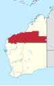
The Pilbara is a large, dry, thinly populated region in the north of Western Australia. It is known for its Aboriginal peoples; its ancient landscapes; the red earth; and its vast mineral deposits, in particular iron ore. It is also a global biodiversity hotspot for subterranean fauna.

<span class="mw-page-title-main">Wheatbelt (Western Australia)</span> Region of Western Australia

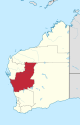
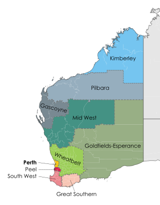
The Wheatbelt is one of nine regions of Western Australia defined as administrative areas for the state's regional development, and a vernacular term for the area converted to agriculture during colonisation. It partially surrounds the Perth metropolitan area, extending north from Perth to the Mid West region, and east to the Goldfields–Esperance region. It is bordered to the south by the South West and Great Southern regions, and to the west by the Indian Ocean, the Perth metropolitan area, and the Peel region. Altogether, it has an area of 154,862 square kilometres (59,793 sq mi).

Horizon Power is a commercially focused, state government-owned, power company that provides power supplies to Western Australia. It is responsible for generating, procuring, distributing and retailing electricity to residential, industrial and commercial customers and resource developments in its service area.

<span class="mw-page-title-main">Australian rules football in Western Australia</span>

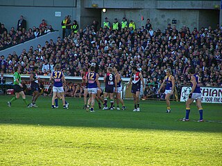
Australian rules football in Western Australia (WA) is the most popular sport in the state and Western Australia has the second highest number of Australian rules football participants of any state.

<span class="mw-page-title-main">Pilbara newspapers</span> Newspapers published in the Pilbara region of Western Australia

Pilbara newspapers is a selection of newspapers published in the Pilbara region of Western Australia.

<span class="mw-page-title-main">North West Australia</span> Region of Western Australia

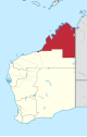
The North West, North West Coast, North Western Australia and North West Australia, are usually informal names for the northern regions of the State of Western Australia. However, some conceptions of "North West Australia" have included adjoining parts of the Northern Territory (NT) – or even the entire NT.

Western Australia has the longest coastline of any state or territory in Australia, at 10,194 km or 12,889 km. It is a significant portion of the coastline of Australia, which is 35,877 km.

The south coast of Western Australia comprises the Western Australian coastline from Cape Leeuwin to Eucla. This is a distance of approximately 1,600 kilometres (1,000 mi), fronting the Great Australian Bight and the Southern Ocean.

<span class="mw-page-title-main">Regional Development Commissions Act 1993</span>

The Regional Development Commissions Act 1993 is legislation passed by the Parliament of Western Australia:

to establish regional development commissions, to coordinate and promote the development of regions and to establish a regional development council.

The 1900 Western Australian floods were a series of flooding events from March to May 1900 that affected large areas of Western Australia, primarily in the Pilbara and Gascoyne regions, though it extended to cover most of the state except the more humid Kimberley and South West regions.

<span class="mw-page-title-main">West Australian Country Football League</span>

The Australian Country Football League (WACFL) is the governing body for the sport of Australian rules football in the non-metropolitan areas of Western Australia. The organisation was founded in 1973 as the Western Australian National Country Football League (WANCFL), its name to the current in 1979. The WACFL is also responsible for organising the Landmark Country Football Championships, contested between the various regional sides. The Australian Country Football Championships were hosted by Bunbury in 2004.

The Eremaean province is a botanical region in Western Australia, characterised by a desert climate. It is sometimes referred to as the dry and arid inland or interior region of Western Australia It is one of John Stanley Beard's phytogeographic regions of WA, based on climate and types of vegetation who, in "Plant Life of Western Australia" (p. 29-37) gives a short history of the various mappings.

Newspapers published or distributed in the Gascoyne region of Western Australia have been spread over a large distance, and in varying degrees of success. The region has a low population density, and some communities, apart from Carnarvon, would not be sufficient to support long term newspaper production.

A modest number of newspapers have been produced in, or for, the Kimberley region of Western Australia. Few are still being published today. Some of the newspapers reflect the economic interests of the region, but not to the same extent that is seen in Pilbara newspapers. There is some cross-over between newspapers distributed in both the Kimberley and the Pilbara.

<span class="mw-page-title-main">Botanical Provinces of Western Australia</span> Botanical regions in Western Australia

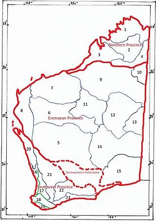
The botanical provinces of Western Australia (or Beard's Provinces) delineate "natural" phytogeographic regions of WA, based on climate and types of vegetation. John Stanley Beard, in "Plant Life of Western Australia" (p. 29-37) gives a short history of the various mappings.

References

  1. "Regional Development Commissions Act 1993". State Law Publisher, Government of Western Australia. Retrieved 6 November 2013.
  2. "Gascoyne". Department of Primary Industries and Regional Development. Archived from the original on 18 June 2020. Retrieved 18 June 2020.
  3. "Goldfields–Esperance". Department of Primary Industries and Regional Development. Archived from the original on 18 June 2020. Retrieved 18 June 2020.
  4. "Great Southern". Department of Primary Industries and Regional Development. Archived from the original on 18 June 2020. Retrieved 18 June 2020.
  5. "Kimberley". Department of Primary Industries and Regional Development. Archived from the original on 18 June 2020. Retrieved 18 June 2020.
  6. "Mid West". Department of Primary Industries and Regional Development. Archived from the original on 18 June 2020. Retrieved 18 June 2020.
  7. "Peel". Department of Primary Industries and Regional Development. Archived from the original on 18 June 2020. Retrieved 18 June 2020.
  8. "Pilbara". Department of Primary Industries and Regional Development. Archived from the original on 18 June 2020. Retrieved 18 June 2020.
  9. "South West". Department of Primary Industries and Regional Development. Archived from the original on 18 June 2020. Retrieved 18 June 2020.
  10. "Wheatbelt". Department of Primary Industries and Regional Development. Archived from the original on 18 June 2020. Retrieved 18 June 2020.
  11. "New COVID-19 restrictions on travel within WA as big queues form on WA/SA border ahead of closure – ABC News". Australia: ABC News. 24 March 2020. Retrieved 8 May 2020.
  12. "WA drivers confronted by army checkpoints". 7News. 1 April 2020. Retrieved 16 May 2020.
  13. "Coronavirus in Australia: Army called in to help enforce strict new quarantine rules". 7News. 28 March 2020. Retrieved 16 May 2020.
  14. 1 2 "Remote Aboriginal Communities (COVID-19)". Department of Communities. Retrieved 17 May 2020.
  15. "COVID-19 coronavirus: Regional travel restrictions". Government of Western Australia. 15 May 2020. Retrieved 16 May 2020.
  16. "COVID-19 coronavirus: WA Roadmap". Government of Western Australia. 14 May 2020. Retrieved 16 May 2020.
  17. "COVID-19 coronavirus: Regional travel restrictions". Government of Western Australia. 5 June 2020. Retrieved 6 June 2020.
  18. 1 2 Laschon, Eliza (31 January 2021). "COVID lockdown announced for Perth and South West after quarantine hotel worker tests positive". Australia: ABC News. Retrieved 31 January 2021.
  19. "Western Australian Forecast Areas Map". Archived from the original on 2 March 2008. Retrieved 1 March 2008. – noting the changes in 2012 – http://www.bom.gov.au/NexGenFWS/wa/districts.shtml#new-districts-map
  20. http://www.bom.gov.au/wa/forecasts/sw-wa-fire-forecasts.shtml South West Western Australia Fire Weather Forecast Areas
  21. "Education Department of Western Australia – Schools Online". Archived from the original on 14 November 2011. Retrieved 16 October 2011.
  22. http://www.agric.wa.gov.au/PC_93310.html?s=2048819175 [ dead link ]
  23. "Our Role in the Regions – Main Roads Western Australia". Archived from the original on 21 October 2013. Retrieved 3 October 2013.
  24. "Department of Water :: Water regions". Archived from the original on 30 November 2010. Retrieved 17 December 2010.
  25. "Recreational fishing rules".
  26. (1981) Map of Western Australia showing Administrative Divisions and Principal mines and operators
  27. Department of Planning; Western Australian Planning Commission (22 January 2013). "Region and local planning schemes". Government of Western Australia. Archived from the original on 9 April 2013. Retrieved 4 November 2013.
  28. "Archived copy" (PDF). Archived from the original (PDF) on 2 February 2015. Retrieved 2 February 2015.{{cite web}}: CS1 maint: archived copy as title (link)
  29. "WA Country Health Service – Overview".
  30. "About us".
  31. http://www.agric.wa.gov.au/PC_93285.html?s=1392304539 [ dead link ]
  32. T. Stevenson "The Sotheby's Wine Encyclopedia" pg 589 Dorling Kindersley 2005 ISBN   0-7566-1324-8
  33. Australian Wine and Brandy corporation – Western Australia Archived 22 July 2008 at the Wayback Machine
  34. winepros.com.au, The Oxford Companion to Wine pg 765 Western Australia Archived 26 March 2015 at the Wayback Machine
  35. "Western Australia's Wine Regions". Western Australia. Archived from the original on 27 November 2010. Retrieved 25 November 2010.
  36. Short, Andrew D (2005)Beaches of the Western Australian Coast: Eucla to Roeback Bay ISBN   0-9586504-3-8. page 1
  37. Western Australian Forecast Areas Map Archived 2 March 2008 at the Wayback Machine
  38. "'StreetSmart Touring Map – Batavia Coast Western Australia ISBN   0-7309-2935-3
  39. "1216.0 – Australian Standard Geographical Classification (ASGC), 2001". Australian Bureasu of Statistics. 28 September 2001. Retrieved 17 October 2011.

Further reading

Maps