Northwest India

Last updated

Northwest India
Northwest India map.svg
Country India
States and territories
Largest city New Delhi
Most populous cities (2011)
Area
  Total836,566 km2 (323,000 sq mi)
Population
 (2011)
  Total368,791,165
  Density440/km2 (1,100/sq mi)
Time zone IST (UTC+5:30)
Native languages

Northwest India is a loosely defined region of India consisting of northwestern states of the Republic of India. It generally includes the states of Himachal Pradesh, Punjab, Haryana, Uttarakhand, Rajasthan [1] and often Uttar Pradesh, [2] [3] [4] [5] along with the union territories of Ladakh, Jammu and Kashmir, [6] [lower-alpha 1] Chandigarh and the National Capital Territory of Delhi. [lower-alpha 2] Gujarat is occasionally included as well. [7] [8] [9] The mountainous upper portion of Northwest India consists of the Western Himalayas, while the flat lower portion consists of the middle portion of the Indo-Gangetic plains and the Thar Desert

Contents

Northwest India borders Pakistan to the west, and the Tibet Autonomous Region and Xinjiang of China to the northeast. [lower-alpha 3] Before the partition of India, the term "Northwest India" included the entirety of Punjab, Sindh [9] and North West Frontier Province, in addition to the territory of modern-day India west of the 77th meridian east and north of the 24th parallel north. [10]

Since the ancient period, the region has been subject to foreign invasions. In the ancient era, it was part of the Indo-Greek Kingdom, followed by the Kushan Empire. The region was invaded and conquered by the Ghorid Empire in the twelfth century. In the eighteenth century, the region was invaded and ransacked by Iran and Afghanistan. In the late eighteenth and early nineteenth centuries, the Punjab region was ruled by Sikh Misls. The Rajputs ruled the Thar region and occasionally the upper plains from the mediaeval era till the formation of the Indian Union (1947). The Kingdom of Kashmir existed from the ancient era until its conquest in 1586 by Akbar the Great, Shahenshah of Hindustan. It was re-instated in 1849 and existed till its accession to the Indian Union in 1947.

The Kashmir region is disputed between India, Pakistan and China. India claims the entirety of Kashmir apart from the Trans-Karakoram Tract, but the regions of Gilgit-Baltistan and AJK is controlled by Pakistan while Trans-Karakoram Tract and Aksai Chin is controlled by China.

History

Ancient era

The Macedonian Empire, 336-323 (William R. Shepherd).jpg
Achaemenid Empire 500 BCE.jpg
The Macedonian Empire (left) after conquering the First Persian Empire (right).

The region was a part of the Indus Valley civilisation until it decayed and following the Indo-Aryan migrations, the Kingdom of Kashmir in Kashmir region and other small kingdoms in the Gangetic plains were established during the Vedic era. [11] The surrounding region was part of the First Persian Empire until it was briefly conquered by the Macedonian Empire under Alexander the Great, [12] [13] following which the region was conquered by the Magadhan Empire under Chandragupta Maurya. In 185 BC, Demetrius I, the son of the King of Bactria, conquered the western part of the Magadhan Empire and established the Indo-Greek Kingdom. After the death of Menander I in 130 BC, multiple Indo-Greek kingdoms ruled various territories in the region. Indo-Scythians, in modern-day Afghanistan, Balochistan and Sindh, warred with the Indo-Greeks eventually captured all of their strongholds except the one at Sagala. In middle Ganga plain, the Kingdom of Panchala regained its independence from the collapsing Magadhan Empire in 107 BC.

In AD 10, the Indo-Scythian satrap of Mathura captured the last Indo-Greek stronghold at Sagala. In AD 19, the Governor of Sakastan in the Parthian Empire to the west declared independence and established the Indo-Parthian Kingdom. The Indo-Parthian Kingdom was conquered by the Kushan Empire by the mid-first century and in the early second century conquered the Indo-Scythian kingdom of Mathura. [14] The Kushan Empire expanded further into the Gangetic plain and made the Kingdom of Panchala its tributary state for a brief period until early third century when it lost controlled over northwest India. By mid third century, the Kushan Empire had fallen under the control of the Second Persian Empire. Multiple kingdoms came up in northwest India. Some of these were the Yaudheya Confederation and the Arjunayana State. To the east still existed the Kingdom of Panchala.

The Magadhan Empire was restored by Chandragupta I of the House of Gupta in AD 319. Large conquests were made to the empire under Samudragupta (reign. AD 335–375). Panchala was conquered by the Magadhan Empire in AD 350. The entire northwestern region of the Indian subcontinent except Kashmir was brought under Magadhan domination between AD 370 and 380 and was annexed between AD 400 and 405.

However the power of the Magadhan Empire was to last not for many years longer. The First Hunnic War (496–515), between the Alcon Huns and the Magadhan Empire led to conquest of western Magadhan Empire by the Huns. The Kingdom of Malwa which had been a feudatory of the Magadhan Empire defeated and conquered much of the Hunic kingdom in 528. However, Malwa collapsed in 550 and the Kingdom of Thanesar became an independent kingdom in upper gangetic plain. In 556, the Kingdom of Kannauj became independent from Magadha in the middle plains. The remaining eastern part of the Magadhan Empire collapsed and broke into multiple small kingdoms in the late sixth century.

Medieval era

In 607, Harsha became the King of Thanesar. He conquered the Kingdom of Kannauj, the richest city in entire North India and became the Emperor of Kannauj. The empire however was short-lived and collapsed in 647. The rump state of Kannauj was ruled by Arunasva.

Between 725 and 770, Kingdom of Kannauj was ruled by the House of Varman. In 770, Bhoja, King of Kannauj was deposed by Vajrayudha founding the House of Ayudha. This triggered Kannauj Wars (770–854) for the control over the Kingdom of Kannauj between three great powers — the Gurjara Empire under the Rajput Pratihara dynasty, the Bengal Empire under the House of Pala, and the Rashtrakuta Empire. In 785, Vatsaraja, the Gurjara Emperor invaded Kannauj, made Indrayudha, the King of Kannuj his vassal. In response to this, Dharmapala, the Emperor of Bengal invaded Kannauj and deposed Indrayudha and replaced him with Indrayudha's brother, Chakrayudha whom he made his vassal. This obviously led to war and the Gurjara Empire defeated Bengal and the Gurjara Emperor Vatsaraja occupied Kannauj. Rashtrakuta Emperor Dhruva defeated the Gurjara Empire and Vatsaraja fled his empire, while Dhruva returned to his empire. Bengal re-installed Chakrayudha as the King of Kannauj and its vassal.

After the death of Dhruva in 793, the Rashtrakuta Empire fell into a war of succession. In the Gurjara Empire, the son of Vatsaraja, Nagabhata II, seeking revenge and taking advantage of the succession crisis in the Rashtrakuta Empire, invaded Kannauj and defeated Dharmapala and made Chakrayudha his vassal. Before he could invade Bengal however, the new Rashtrakuta Emperor Govinda III invaded Kannauj and defeated the Gurjara armies, and Nagabhatta retreated back to his empire. Dharmapala and Chakrayudha acknowledged Govinda III as their overlords to earn his friendship after which Govinda went back and Kannauj came back under Bengal rule in 800. Kannauj remained a vassal of the Bengal Empire until 816 when the Gurjara Emperor Nagabhata II invaded the Kingdom of Kannauj and conquered it and made the city of Kannauj its capital.

In 912, owing to an inner conflict, multiple feudatory kingdoms declared their independence — the Kingdom of Malwa, the Kingdom of Jejakabhukti, the Kingdom of Tripuri, the Kingdom of Sambhar (later the Kingdom of Ajmer) under the House of Chauhan, and the Kingdom of Delhi under the House of Tomar. The Kingdom of Kannauj was revived by the House of Gahadavala in 1089 by ousting the Kingdom of Tripuri to its southern territories. The Kingdom of Amber and the Kingdom of Jaisalmer declared independence from the Kingdom of Sambhar in 1128 and 1156 respectively. The Kingdom of Sambhar conquered the Kingdom of Delhi in 1152.

A light cavalry soldier from the 15th-century Delhi Sultanate under Khizr Khan. Sayyid Light Cavalry.jpg
A light cavalry soldier from the 15th-century Delhi Sultanate under Khizr Khan.

The Ghurid Empire conquered the Kingdom of Sambhar in 1192 and the Kingdom of Kannauj in 1197. However the empire collapsed in 1206 and the Indian territories were consolidated by his general Qutub-ud-din Aibak, who proclaimed himself the Sultan of Delhi in 1206. This region was the core of the Delhi Sultanate for the following centuries. The Delhi Sultanate defeated the invading Mongol Empire and saved India from the destruction that had met Central and Western Asia.

Modern era

In 1526, Babur, Emir of Kabul, defeated Ibrahim Lodhi, Sultan of Delhi and took over the sultanate. Following this, he defeated the Rajput Confederation and proclaimed himself the Padishah of Hindustan (King of India) and founded the House of Babur (Mughal dynasty). In 1556, Akbar the Great was crowned Shahenshah of Hindustan (Emperor of India) amid a civil war against the House of Suri in the Hindustani Empire. He annexed the Kingdom of Kashmir in 1586 and brought the Rajput kingdoms under his suzerainty.

British troops crossing the Sutlej river during the First Anglo-Sikh war. British troops crossing the Sutlej (Punjab) in boats. 10 February 1846.jpg
British troops crossing the Sutlej river during the First Anglo-Sikh war.

In the eighteenth century, Punjab region broke free, and the Sikh Confederacy was established in the region. The remaining portion remained a part of the empire. During this period, the region and the empire was invaded by the Iranian Empire, followed by the Afghan Empire. The East India Company controlled the British territories within the Hindustani Empire and nominally functioned under the authority of the Shahenshah of Hindustan. It took over western parts of the Awadh province from the Nawab (governor) in 1783 and in 1803 became the official protectors of the Shahenshah. It made subsidiary military alliances with Rajput states in 1818. The same year the Nawab of Awadh declared his independence and established the Kingdom of Awadh, however it wasn't recognised widely, not even by the people of Awadh who continued to call him Nawab. In 1835, the East India Company stopped recognising the authority of the Shahenshah of Hindustan, at that time Akbar II, and downgraded him to King of Delhi. The East India Company annexed parts of the Sikh Empire in 1846 and re-established the Kingdom of Kashmir, and conquered the entirety of the Sikh Empire in 1849. In 1856, it annexed the Kingdom of Awadh.

In 1857, the troops of the Bengal Army under the East India Company mutinied and marched towards Delhi. The troops in the forts on their way also mutinied and joined them. They finally reached Delhi in 12 May, and proclaimed Bahadur Shah II the Shahenshah of Hindustan. The Shahenshah declared war against the East India Company and wrote letters to the various kingdoms and principalities of the erstwhile empire. Many declared their allegiance to the Shahenshah and supported the declaration of war. In many states that supported the company, the troops rebelled and acquired control, and joined the war nonetheless. However many of the larger states like Hyderabad, Mysore and Kashmir remained neutral. The United Kingdom got involved in this war after the East India Company suffered initial defeats. The war lasted until 1858 after which Britain proclaimed its victory. Bahadur Shah was exiled to Burma and the British Crown began directly ruling British territories in India and dissolved the East India Company. [15] The various alliances and treaties with various kingdoms and states (such as the Kingdom of Kashmir and Punjab and Rajput states) made by the East India Company were transferred to the British Crown as well. In 1876, Victoria was declared the Empress of India, and the Indian Empire was established consisting of British India and the various princely states.

In 1947, the Indian Empire was dissolved and British India was divided into the Dominion of India and the Dominion of Pakistan while the various princely states acceded to one of the two states. The First Kashmir War was fought between the Indian Union and Pakistan from 1947 to 1948 over the Kingdom of Jammu and Kashmir, resulting in Gilgit-Baltistan in the northwestern part of the kingdom and an eastern strip becoming a part of Pakistan. In 1961, the Sino-Indian War, broke out between the Indian Republic and the newly established People's Republic of China, resulting in Aksai Chin coming under Chinese control. The Second Kashmir War (1965) was inconclusive with minor territorial changes in the region. The Indo-Pakistani war of 1971 during the Bangladesh Liberation War, lasted for only 13 days, and culminated in an Indian victory with minor territorial changes in the Kashmir region.

Organisation

Indian Empire

In late nineteenth century, the region had three provinces – North-Western Provinces, Chief Commissioner's Province of Oudh and the Province of the Punjab. To the extreme there was the Kingdom of Kashmir and Jammu, below that the Punjab States, and to its south, the Rajputana Agency.

By 1945, the region had been slightly re-organised. The Punjab States Agency was created out of the Punjab States, and the Chief Commissioner's Province of Delhi was created out of Punjab Province. The Oudh province and the North-Western provinces had been merged to form the United Provinces of Agra and Oudh.

Union of India

After the dissolution of the Indian Empire and the partitioning of British India, the Dominion of India was created which included the Province of East Punjab and the United Provinces to the north west. Jammu and Kashmir, the Punjab States Agency (except Bahawalpur) and the Rajputana Agency joined the Union of India. Following this, the Patiala and East Punjab States Union, the Rajasthan Union and Province of Himachal Pradesh were created.

Republic of India

After India became a republic in 1950, all provinces were declared States of the Indian Union. United Provinces became the State of Uttar Pradesh and the State of Himachal Pradesh, State of Punjab, State of Rajasthan and State of Jammu and Kashmir were created. Delhi Province became a union territory.

In 1966, Haryana was formed, and in 2000, Uttarakhand was formed. In 2019, the statehood of Jammu and Kashmir was terminated and the union territories of Jammu and Kashmir and Ladakh were created.

Geography

The border between Northwest India and Pakistan. India-Pakistan border.png
The border between Northwest India and Pakistan.

The region consists of four main regions – the Western Himalayas covering the states and territories of Jammu and Kashmir, Ladakh, Himachal Pradesh and Uttarakhand; the Trans-Gangetic plain covering the states of Punjab and Haryana; the Upper Gangetic plain covering the states of Uttar Pradesh and the National Capital Territory; and the Thar Desert covering the state of Rajasthan.

The northern part is mountainous and includes the Western Himalayas and extends into the Tibetan plateau. The states of Jammu and Kashmir, Himachal and Uttarakhand are located in the Western Himalayas. The union-governed territory of Ladakh is the western part of the Tibetan plateau.

The southern region is flat and consists of the middle portion of Indo-Gangetic plains and the Thar Desert. The states of Punjab and Haryana are located in the Trans-Gangetic plain along with the territories of Chandigarh and National Capital Territory, and the state of Uttar Pradesh is located in the Upper Gangetic plain or the Doab region. The state of Rajasthan extends across the Thar Desert and a small part of the Gangetic plain.

Languages

The languages spoken in this region belongs to the Indo-Aryan language family of the Indo-European languages. The languages belong to six main branches: Dardic languages, Pahari languages, North Western Indo-Aryan languages, Rajasthani languages and Central Indo-Aryan languages. Kashmiri and Dogri of Pahari languages is spoken in Jammu and Kashmir, Punjabi of North-Western Indo-Aryan languages is spoken in Punjab, Kumaoni and Garhwali of Pahari languages are spoken in Uttarakhand, Himachali languages of Pahari languages are spoken in Himachal Pradesh, Haryanvi of Central Indo-Aryan languages is spoken in Haryana, Hindi and Awadhi of Central Indo-Aryan languages are spoken in Uttar Pradesh, and Rajasthani languages are spoken Rajasthan.

See also

Related Research Articles

<span class="mw-page-title-main">Kashmir</span> Territory disputed between China, India, and Pakistan

Kashmir is the northernmost geographical region of the Indian subcontinent. Until the mid-19th century, the term "Kashmir" denoted only the Kashmir Valley between the Great Himalayas and the Pir Panjal Range. Today, the term encompasses a larger area that includes the India-administered territories of Jammu and Kashmir and Ladakh, the Pakistan-administered territories of Azad Kashmir and Gilgit-Baltistan, and the Chinese-administered territories of Aksai Chin and the Trans-Karakoram Tract.

<span class="mw-page-title-main">Punjab</span> Ethnolinguistic and geographical region in South Asia

Punjab, historically known as Pentapotamia or Panchanada, is a historical, geopolitical, ethnolinguistic and cultural region in the northwestern part of South Asia, along the five major eastern tributaries of the Indus River in the Indian Subcontinent. The region is divided between modern-day eastern-Pakistan and northwestern-India.

<span class="mw-page-title-main">Middle kingdoms of India</span> Political entities in the Indian subcontinent from 3rd century BCE - 13th century CE

The middle kingdoms of India were the political entities in the Indian subcontinent from 230 BCE to 1206 CE. The period begins after the decline of the Maurya Empire and the corresponding rise of the Satavahana dynasty, starting with Simuka, from 230 BCE. The "middle" period lasted for almost 1436 years and ended in 1206 CE, with the rise of the Delhi Sultanate, founded in 1206, and the end of the Later Cholas.

<span class="mw-page-title-main">States and union territories of India</span> Indian national administrative sub-divisions

India is a federal union comprising 28 states and 8 union territories, for a total of 36 entities. The states and union territories are further subdivided into districts and smaller administrative divisions.

<span class="mw-page-title-main">Indo-Gangetic Plain</span> Geographical plain in South Asia

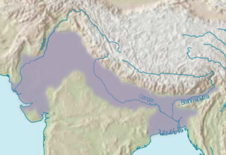
The Indo-Gangetic Plain, also known as the North Indian River Plain, is a 700-thousand km2 (172-million-acre) fertile plain encompassing northern regions of the Indian subcontinent, including most of modern-day northern and eastern India, most of eastern-Pakistan, virtually all of Bangladesh and southern plains of Nepal. Also known as the Indus–Ganga Plain, the region is named after the Indus and the Ganges rivers and encompasses a number of large urban areas. The plain is bounded on the north by the Himalayas, which feed its numerous rivers and are the source of the fertile alluvium deposited across the region by the two river systems. The southern edge of the plain is marked by the Deccan Plateau. On the west rises the Iranian Plateau. Many developed cities like Delhi, Dhaka, Kolkata, Lahore, Islamabad and Karachi are located in the Indo-Gangetic Plain.

<span class="mw-page-title-main">Kannauj</span> City in Uttar Pradesh, India

Kannauj is a city, administrative headquarters and a municipal board or Nagar Palika Parishad in Kannauj district in the Indian state of Uttar Pradesh. The city's name is an evolved form of the classical name Kanyakubja. It was also known as Mahodaya during the time of Mihira Bhoja. It is situated 104 kilometres west of the state capital, Lucknow.

<span class="mw-page-title-main">Gurjara-Pratihara dynasty</span> Mid-8th to 11th century northern India dynasty

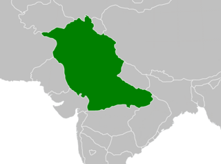
The Gurjara-Pratihara was a dynasty that ruled much of Northern India from the mid-8th to the 11th century. They ruled first at Ujjain and later at Kannauj.

<span class="mw-page-title-main">Hindi Belt</span> Linguistic region of India

The Hindi Belt, also known as the Hindi Heartland, is a linguistic region encompassing parts of northern, central, eastern, and western India where various Northern, Central, Eastern and Western Indo-Aryan languages are spoken, which in a broader sense is termed as Hindi languages, with Standard Hindi serving as the lingua franca of the region.

<span class="mw-page-title-main">North India</span> Region of India

North India, also called Northern India, is a geographical and broad cultural region comprising the northern part of India wherein Indo-Aryans form the prominent majority population. It extends from the Himalayan mountain range in the north to the Indo-Gangetic plains, the Thar Desert, the Central Highlands and the northwestern part of the Deccan plateau. It occupies nearly three-quarters of the area and population of India and includes all of the three mega cities of India: Mumbai, Delhi and Kolkata. In a more specific and administrative sense, North India can also be used to denote the Indo-Gangetic Plain within this broader expanse, stretching from the Ganga-Yamuna Doab to the Thar Desert.

The Dogras or Dogra people, are an Indo-Aryan ethno-linguistic group living primarily in the Indian union territory of Jammu and Kashmir and neighbouring Pakistan, consisting of the Dogri language speakers. They live predominantly in the Jammu region of Jammu and Kashmir, and in adjoining areas of Punjab and Himachal Pradesh. Some also live in northeastern Pakistan. Their historical homeland is known as Duggar.

<span class="mw-page-title-main">Mihira Bhoja</span> Pratiharan Emperor from 836 to 885

Mihira Bhoja or Bhoja I was the Pratiharan Emperor from 836 to 885 CE. He inherited a weakened realm in an adverse situation from his father, Ramabhadra. However, his capable reign transformed it into a large and prosperous empire. Bhoja was a devotee of Vishnu and adopted the title of Ādivarāha, which is inscribed on some of his coins.. One of the outstanding political figures of India in the ninth century, he ranks with Dhruva Dharavarsha and Dharmapala as a great general and empire builder.

The Gurjar are an Indo-Aryan agricultural ethnic community, residing mainly in India, Pakistan and Afghanistan, divided internally into various clan groups. They were traditionally involved in agriculture, pastoral and nomadic activities and formed a large heterogeneous group. The historical role of Gurjars has been quite diverse in society: at one end they have been founders of several kingdoms and dynasties and, at the other end, some are still nomads with no land of their own.

<span class="mw-page-title-main">Outline of India</span> Overview of and topical guide to India

The following outline is provided as an overview of, and topical guide to, India:

<span class="mw-page-title-main">Jammu and Kashmir (princely state)</span> Former princely state

Jammu and Kashmir, also known as Kashmir and Jammu, was a princely state in a subsidiary alliance with the British East India Company from 1846 to 1858 and under the paramountcy of the British Crown, from 1858 until the Partition of India in 1947, when it became a disputed territory, now administered by three countries: China, India, and Pakistan. The princely state was created after the First Anglo-Sikh War, when the East India Company, which had annexed the Kashmir Valley, from the Sikhs as war indemnity, then sold it to the Raja of Jammu, Gulab Singh, for rupees 75 lakhs.

The Western Air Command (WAC) is the regional command of Indian Air Force headquartered in New Delhi. It is the largest and most important Air Command of the IAF, comprising sixteen Air Force Bases (AFBs), and is responsible for aerial defence of North India.

Pahari, or Pahadi is an ambiguous term that has been used for a variety of languages, dialects and language groups, most of which are found in the lower Himalayas.

<span class="mw-page-title-main">States Reorganisation Act, 1956</span> Indian act reforming state boundaries

The States Reorganisation Act, 1956 was a major reform of the boundaries of India's states and territories, organising them along linguistic lines.

<span class="mw-page-title-main">History of Uttar Pradesh</span> History of the state in Northern India

The history of Uttar Pradesh, a state in India, stretches back several millennia. The region shows the presence of human habitation dating back to between 85,000 and 73,000 years ago. Additionally, the region seems to have been domesticated as early as 6,000 BC.

Hun or Huna is an ancient clan of the Gurjar ethnic community of Pakistan, Afghanistan, and India. Historically, they were also known by the name of Huna. They are primarily Hindu, while some are Muslim in Kashmir and Pakistan. In mountainous areas, they speak the Gujari language, as well as other indigenous dialects.

<span class="mw-page-title-main">Kingdom of Malwa</span> Kingdom in central India

The Kingdom of Malwa was a monarchy in central India that was established by Jayavarman of the House of Aulikara in 350 AD. It was ruled by multiple royal houses discontinuously until it was finally conquered in 1562 by Akbar the Great, the Shahenshah of Hindustan, and annexed as the Malwa Province.

References

  1. Mitigation, Management and Control of Floods in South Asia Volume One. UN Habitat. Inland drainage in India is mainly ephemeral and almost entirely in the arid and semiarid part of northwestern India, particularly in the Great Indian Desert of Rajasthan,
  2. Haddix, Kimber. Marital Strategies in a Polyandrous Tibetan Community in Northwest Nepal. In many areas of northwestern India, especially in Himachal Pradesh and Uttar Pradesh such as Jaunsar Bawar, Kumaon and Garhwal districts, sex ratios that were significantly
  3. Buckley, Michael. Tibet. in northwest India, there are about 21,000 in Himachal Pradesh, 6,500 in Uttar Pradesh, and 5,000 in Ladakh; in central India, about 8,000; in south India, approximately 30,000; in northeast India, an estimated 8,000; while 14,300 live
  4. Noble, Allen. India: Cultural Patterns And Processes. Because they are primarily milk producers, the greatest numbers of water buffalo are found in northwest India, from the Punjab to Uttar Pradesh, in places where there are lower densities of human population and greater availability of feed.
  5. Byerlee, Derek. Dryland Wheat in India. the traditional wheat belt of northwestern India (Uttar Pradesh, Punjab, and Haryana) also recorded above average growth in wheat area.
  6. Rao, M.S.V.; Srinivasan, V.; Raman, S. (September 1970). Forecasting Manual Part Iii Discussion Of Typical Synoptic Weather Situations 3.3: Southwest Monsoon -Typical Situations Over Northwest India. India Meteorological Department . p. 1.
  7. Tavernini, Maria. "Severe drought threatens delicate ecosystem in Gujarat". Al Jazeera. Retrieved 16 April 2024.
  8. Dixit, Mayank; Ram Bansal, Abhey; Mangalalampally, Ravi Kumar; Singha Roy, Ketan; Teotia, Satybir Singh (1 August 2022). "Dynamically Triggered Events in a Low Seismically Active Region of Gujarat, Northwest India, during the 2012 Mw 8.6 Indian Ocean Earthquake". The Bulletin of the Seismological Society of America. 112 (4): 1908–1920. Bibcode:2022BuSSA.112.1908D. doi:10.1785/0120210142. ISSN   0037-1106.
  9. 1 2 A Brief History of India Emiliano Unzer "In cultural and religious terms, India was home to Hinduism, Buddhism, Jainism, Sikhism among others, and sheltered the Zoroastrians from the Persian lands to the west, as well as the place where Islam flourished since the 7th century through Gujarat and Sindh in northwest India."
  10. Ramaswamy, C. (1987). Meteorological Aspects of Severe Floods in India, 1923-1979. Meteorological monograph: Hydrology. India Meteorological Department. p. 17. Retrieved 7 April 2024.
  11. Vikas Nain, "Second Urbanization in the Chronology of Indian History", International Journal of Academic Research and Development3 (2) (March 2018), pp. 538–542 esp. 539.
  12. Ulrich Wilcken (1967). Alexander the Great . W.W. Norton & Company. p.  146. ISBN   978-0-393-00381-9.
  13. Taagepera, Rein (1979). "Size and Duration of Empires: Growth-Decline Curves, 600 B.C. to 600 A.D". Social Science History. 3 (3/4): 123. doi:10.2307/1170959. JSTOR   1170959. A superimposition of the maps of Achaemenid and Alexander's empires shows a 90% match, except that Alexander's realm never reached the peak size of the Achaemenid realm.
  14. Si-Yu-Ki: Buddhist Records of the Western World. The mission of Sung-Yun and Hwei-Săng [by Hsüan-chih Yang] Ta-T'ang si-yu-ki. Books 1–5. Translated by Samuel Beal. London: Kegan Paul, Trench, Trubner & Co. 1906.
  15. David Kenneth Fieldhouse (1985). Select Documents on the Constitutional History of the British Empire and Commonwealth: Settler self-government, 1840–1900. Greenwood Publishing Group. p. 37. ISBN   978-0-313-27326-1.
  1. India also claims the remainder of the Kashmir region, which is controlled by Pakistan and China.
  2. India also claims two pieces of territory that are adjacent to disputed Indian-claimed territories in the northwest and which are controlled by China as part of Xinjiang: Aksai Chin, which borders Indian-administered Kashmir, and the Trans-Karakoram Tract, which borders Pakistan-administered Kashmir (see Sino-Indian border dispute).
  3. India also claims to have a border with Afghanistan to the northwest due to its claim on Kashmir, the relevant part of which is controlled by Pakistan. (See Borders of India#Land borders of India.)