
Southampton County is a county located on the southern border of the Commonwealth of Virginia. North Carolina is to the south. As of the 2020 census, the population was 17,996. Its county seat is Courtland.

Franklin is the southwesternmost independent city in Hampton Roads, Commonwealth of Virginia. As of the 2020 census, the population was 8,180. The Bureau of Economic Analysis combines the city of Franklin with Southampton County for statistical purposes.

Chowan County is one of the 100 counties located in the U.S. state of North Carolina. As of the 2020 census, the population was 13,708. Its county seat is Edenton. The county was created between 1668 and 1671 as Shaftesbury Precinct and later renamed Chowan Precinct. It gained county status in 1739.
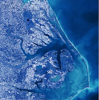
Albemarle Sound is a large estuary on the coast of North Carolina in the United States located at the confluence of a group of rivers, including the Chowan and Roanoke. It is separated from the Atlantic Ocean by the Currituck Banks, a barrier peninsula upon which the town of Kitty Hawk is located, at the eastern edge of the sound, and part of the greater Outer Banks region. Roanoke Island is situated at the southeastern corner of the sound, where it connects to Pamlico Sound. Much of the water in the Albemarle Sound is brackish or fresh, as opposed to the saltwater of the ocean, as a result of river water pouring into the sound.

A blackwater river is a type of river with a slow-moving channel flowing through forested swamps or wetlands. Most major blackwater rivers are in the Amazon Basin and the Southern United States. The term is used in fluvial studies, geology, geography, ecology, and biology. Not all dark rivers are blackwater in that technical sense. Some rivers in temperate regions, which drain or flow through areas of dark black loam, are simply black due to the color of the soil; these rivers are black mud rivers. There are also black mud estuaries.

College of The Albemarle (COA) is a public community college in the Albemarle region of northeastern North Carolina. The main campus is in Elizabeth City with satellite campuses in Barco, Manteo and Edenton. Established on December 16, 1960, College of The Albemarle became the first institution of the North Carolina Community College System as chartered by the Community College Act of 1957.

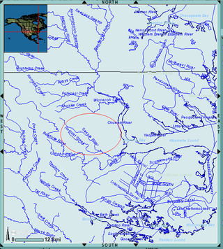
The Chowan River (cho-WAHHN) is a blackwater river formed with the merging of Virginia's Blackwater and Nottoway rivers near the stateline between Virginia and North Carolina. According to the USGS a variant name is Choan River.
The Albemarle Settlements were the first permanent English settlements in what is now North Carolina, founded in the Albemarle Sound and Roanoke River regions, beginning about the middle of the 17th century. The settlers were mainly Virginians, migrating south.

The Blackwater River of southeastern Virginia flows from its source near the city of Petersburg, Virginia for about 105 miles (170 km) through the Inner Coastal Plain region of Virginia. The Blackwater joins the Nottoway River to form the Chowan River, which empties into Albemarle Sound. The Blackwater-Nottoway confluence forms the boundary between Virginia and North Carolina.

The Meherrin River is a 143.37 mi (230.73 km) long 6th order tributary to the Chowan River that joins in Hertford County, North Carolina.

Lunenburg is a census-designated place (CDP) in and the county seat of Lunenburg County, Virginia, United States. The population was 165 at the 2010 census. The community is also known as Lunenburg Courthouse or Lunenburg Court House.
Albemarle County, North Carolina was a county located in the Province of North Carolina. It contained what is now the northeastern portion of the U.S. state of North Carolina.
The Little Nottoway River is a 14.31 mi (23.03 km) long tributary to the Nottoway River in the United States state of Virginia. Located in the southeastern part of the state, it is part of the larger Chowan-Albemarle drainage.
The Jacks Branch is a 2.92 mi (4.70 km) long tributary to the Little Nottoway River in the United States state of Virginia. Located in the southeastern part of the state, it is part of the larger Chowan-Albemarle drainage. The watershed is 61% forested and 26% agricultural with the rest of land as other uses.
The Whetstone Creek is a 10.54 mi (16.96 km) long tributary to the Little Nottoway River in the United States state of Virginia. Located in the southeastern part of the state, it is part of the larger Chowan-Albemarle drainage. The watershed is 65% forested and 32% agricultural with the rest of land as other uses.
The Long Branch is a 3.44 mi (5.54 km) long tributary to the Little Nottoway River in the United States state of Virginia. Located in the southeastern part of the state, it is part of the larger Chowan-Albemarle drainage. The watershed is 58% forested and 38% agricultural with the rest of land as other uses.
Lazaretto Creek is a 8.89 mi (14.31 km) long tributary to the Little Nottoway River in the United States state of Virginia. Located in the south-central part of the state, it is part of the larger Chowan-Albemarle drainage. The watershed is 51% forested and 39% agricultural with the rest of land as other uses.
The Mallorys Creek is a 7.10 mi (11.43 km) long tributary to the Little Nottoway River in the United States state of Virginia. Located in the south-central part of the state, it is part of the larger Chowan-Albemarle drainage. The watershed is 54% forested and 39% agricultural with the rest of land as other uses. This stream joins with Carys Creek to form the Little Nottoway River.
Carys Creek is a 7.06 mi (11.36 km) long tributary to the Little Nottoway River in the United States state of Virginia. Located in the south-central part of the state, it is part of the larger Chowan-Albemarle drainage. The watershed is 74% forested and 25% agricultural with the rest of land as other uses. This stream joins with Carys Creek to form the Little Nottoway River.
Horsepen Creek is a 6.56 mi (10.56 km) long tributary to the Little Nottoway River in the United States state of Virginia. Located in the south-central part of the state, it is part of the larger Chowan-Albemarle drainage. The watershed is 66% forested and 32% agricultural with the rest of land as other uses.

