
Lake of the Woods County is a county in the northwestern part of the U.S. state of Minnesota. As of the 2020 census, the population was 3,763, making it the second-least populous county in Minnesota. Its county seat is Baudette.

Newberg Township is a civil township of Cass County in the U.S. state of Michigan. The population was 1,602 at the 2020 census.

Bois Blanc Township is a civil township of Mackinac County in the U.S. state of Michigan. The population was 100 at the 2020 census. The insular township occupies Bois Blanc Island, as well as some smaller outlying islands within Lake Huron. The nearby Round Island is administered by the city of Mackinac Island.
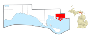
Clark Township is a civil township of Mackinac County in the U.S. state of Michigan. As of the 2020 census, the population was 1,917, down from 2,256 in 2010.
Garfield Township is a civil township of Mackinac County in the U.S. state of Michigan. The population was 1,146 at the 2010 census, and 1,166 in 2020.
Newton Township is a civil township of Mackinac County in the U.S. state of Michigan. As of 2020, its population was 430.

Harris Township is a civil township of Menominee County in the U.S. state of Michigan. The population was 2,113 at the 2020 census.
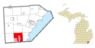
Bedford Township is a civil township of Monroe County in the U.S. state of Michigan. As of the 2020 census, the township population was 31,813.

Clay Township is a civil township of St. Clair County in the U.S. state of Michigan. The population was 8,446 at the 2020 census.

Monticello is a city next to the Mississippi River in Wright County, Minnesota, United States. The population was 14,455 at the 2020 census.
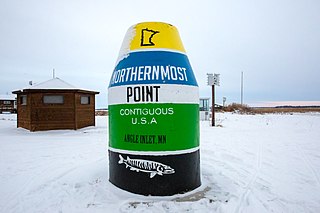
Angle Township is a township in Lake of the Woods County, Minnesota, United States. The population was 119 at the 2010 census. At 49.22° north latitude, it is the northernmost township in Minnesota and the Contiguous United States. The unincorporated communities of Oak Island, Angle Inlet and Penasse are located in the township.

The Northwest Angle, known simply as the Angle by locals, and coextensive with Angle Township, is a pene-exclave of northern Lake of the Woods County, Minnesota. Except for surveying errors, it is the only place in the contiguous United States north of the 49th parallel, which forms the border between the U.S. and Canada from the Northwest Angle westward to the Strait of Georgia. The land area of the Angle is separated from the rest of Minnesota by Lake of the Woods, but shares a land border with Canada. It is one of six non-island locations in the 48 contiguous states that are practical exclaves of the U.S. It is the northernmost township in Minnesota and contains the northernmost point in the contiguous 48 states. The unincorporated community of Angle Inlet is in the Northwest Angle.

Lake of the Woods is a lake occupying parts of the Canadian provinces of Ontario and Manitoba and the U.S. state of Minnesota. Lake of the Woods is over 70 miles (110 km) long and wide, containing more than 14,552 islands and 65,000 miles (105,000 km) of shoreline. It is fed by the Rainy River, Shoal Lake, Kakagi Lake and other smaller rivers. The lake drains into the Winnipeg River and then into Lake Winnipeg. Ultimately, its outflow goes north through the Nelson River to Hudson Bay.
Shawnee Mission is a region of northern Johnson County, Kansas, part of the Kansas City metropolitan area in the United States. Since August 1, 1960, the United States Postal Service has used the name to denote a large postal coverage area at the northeastern tip of Johnson County. It contains numerous towns, and the name was created to structure management of the post offices located therein. Effectively, these towns' post offices are subsidiaries of the Shawnee Mission Main Post Office in Mission, Kansas. Properly, a mailing address may indicate the delivery "place" as either Shawnee Mission, or the actual town name, and be treated the same.

Area code 507 is a telephone area code in the North American Numbering Plan for the southern fifth of Minnesota, including cities such as Rochester, Mankato, Worthington, Fairmont, Albert Lea, Northfield, and Austin. It was the third area code created for use in the state in 1954, following the original 218 and 612. It was created from the southwestern portion of 218 and the southern portion of 612.

The Leech Lake Reservation is an Indian reservation located in the north-central Minnesota counties of Cass, Itasca, Beltrami, and Hubbard. The reservation forms the land base for the federally recognized Leech Lake Band of Ojibwe, one of six bands comprising the Minnesota Chippewa Tribe, organized in 1934. The Leech Lake Reservation has the second highest population of any reservation in Minnesota with White Earth Nation being the largest Minnesota Ojibwe tribe, Leech Lake Nation has a resident population of 11,388 indicated by the 2020 census.

Fort Saint Charles (1732) on Lake of the Woods was the second post built by La Vérendrye during his expansion of trade and exploration west of Lake Superior. It was located on Magnuson's Island on the Northwest Angle of Minnesota, 3.5 miles east of Angle Inlet, Minnesota and one mile southwest of Penasse, Minnesota, the most northerly point in that state. The site of the modern reconstruction may be somewhat different since the lake levels were raised by control structures on the Winnipeg River. For related forts, see Winnipeg River.
Huffman is an unincorporated community of northeastern Harris County, Texas, United States, within the Greater Houston metropolitan area.
Filer City is an unincorporated community and census-designated place in Filer Charter Township, Manistee County, Michigan, United States. Its population was 136 as of the 2020 census. The community is located on Manistee Lake just south of Manistee. Filer City has a post office with ZIP code 49634. The post office opened March 10, 1868, was discontinued on April 12, 1871, and reopened on July 13, 1883.
Nazareth is an unincorporated community and a historic site in Nelson County, Kentucky, United States, located about three miles north of Bardstown. The zipcode is: 40048.
