
Oakridge is a city in Lane County, Oregon, United States. The population was 3,205 as of the 2010 census. It is located east of Westfir on Oregon Route 58, about 40 miles (64 km) east of Eugene and 150 miles (240 km) southeast of Portland. Surrounded by the Willamette National Forest and the Cascade Range, Oakridge is popular with outdoor enthusiasts for its hiking, mountain biking, wildflowers, fly fishing, birding, watersports, and the nearby Willamette Pass Resort.
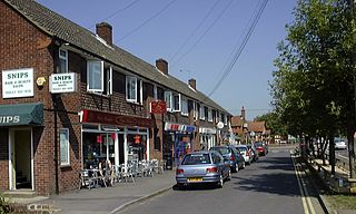
Tadley is a town and civil parish in the English county of Hampshire.

The M3 is a motorway in England, from Sunbury-on-Thames, Surrey, to Eastleigh, Hampshire; a distance of approximately 59 miles (95 km). The route includes the Aldershot Urban Area, Basingstoke, Winchester, and Southampton.
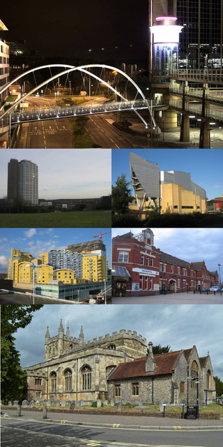
Basingstoke is a town in Hampshire, situated in south-central England across a valley at the source of the River Loddon on the western edge of the North Downs. It is the largest settlement in Hampshire without city status. It is located 30 miles (48 km) north-east of Southampton, 48 miles (77 km) south-west of London, 27 miles (43 km) west of Guildford, 22 miles (35 km) south of Reading and 20 miles (32 km) north-east of the county town and former capital Winchester. According to the 2016 population estimate, the town had a population of 113,776. It is part of the borough of Basingstoke and Deane and part of the parliamentary constituency of Basingstoke.

Basingstoke and Deane is a local government district with borough status in Hampshire, England. The main town is Basingstoke, where the council is based. The district also includes the towns of Tadley and Whitchurch, along with numerous villages and surrounding rural areas. The modern district was created in 1974, initially being called Basingstoke. It changed its name to "Basingstoke and Deane" in 1978 at the same time that it was made a borough; Deane was added to the name to represent the rural parts of the borough, being the area's smallest village.

Old Basing is a village in Hampshire, England, just east of Basingstoke. It was called Basengum in the Anglo-Saxon Chronicle and Basinges in the Domesday Book.

Lasham is a village and civil parish in the East Hampshire district of Hampshire, England. It is 3.4 miles (5.5 km) northwest of Alton and 1.2 miles (1.9 km) north of Bentworth, just off the A339 road. The parish covers an area of 1,797 acres (727 ha) and has an average elevation of 560 feet (170 m) above sea level. The nearest railway station is Alton, 3.5 miles (5.6 km) southeast of the village. Lasham formerly had its own railway station, Bentworth and Lasham, on the Basingstoke and Alton Light Railway until the line's closure in 1936. According to the 2011 census, the village had a population of 176.

Spencers Wood is a village in the civil parish of Shinfield, Berkshire, England, 4 miles (6.4 km) south of Reading. The village of Three Mile Cross adjoins it to the north. To the west lies the village of Grazeley.Basingstoke road goes through Spencers wood

Steventon is a village and a civil parish with a population of about 250 in north Hampshire, England. Situated 7 miles south-west of the town of Basingstoke, between the villages of Overton, Oakley and North Waltham, it is close to Junction 7 of the M3 motorway.

Rooksdown is a civil parish in the Basingstoke and Deane district of Hampshire, England. The parish was formed on 1 April 2004. It covers a small estate in the north-west of Basingstoke which was previously part of the parish of Sherborne St. John, itself originally part of the Vyne estate.

The Malls, Basingstoke is a shopping centre in Basingstoke, Hampshire, England built between 1978 and 1981.

Westfield Oakridge, commonly known as Oakridge, is a shopping mall in San Jose, California, located in the Blossom Valley neighborhood of South San Jose. Established in 1971, Oakridge has been redeveloped multiple times in its history, most recently in 2003, to the cost of $150 million. The mall features Macy's, Target, Nordstrom Rack, and Living Spaces.

Oakridge is a neighbourhood in the city of Toronto, Canada, in the Scarborough district. The community neighbours Birch Cliff to the south, Danforth Village to the east and Cliffside to the west edging onto the Scarborough Bluffs. The neighbourhood is bordered by Victoria Park Avenue to the west, Massey Creek to the north, Warden Avenue to the east travelling south until Mack Avenue which then extends east again to the CNR rail line which forms the southern border.
Kempshott is a ward of Basingstoke on the western edge of the town, to the south of Pack Lane and north of Winchester Road. The population of the ward at the 2011 Census was 6,827.

Oakridge Acres is a neighbourhood in north-west of the City of London, Ontario, Canada. It is north of Westmount and north-east of Byron. The neighbourhood comprises the subdivisions of Oakridge Acres, Oakridge Park, Oakridge Meadows, Thornwood Estates, Hunt Club Green, Hazelden, and Hazelden Park. Almost all of its residents live in low-density, single detached dwellings. As of 2011, the area is home to 16,730 residents. The neighbourhood is considered a middle to upper-income area, with an average family income of $124,966 an average dwelling value of $319,726 and a home ownership rate of 89%.

Chineham is a civil parish on the outskirts of Basingstoke, Hampshire, England. It is situated about 3 miles (5 km) northeast of central Basingstoke, just north of the A33 road between Basingstoke and Reading.
Ellisfield is a village in the Basingstoke and Deane district of Hampshire, England. It lies approximately 4 miles (6.4 km) south of Basingstoke on the other side of the M3 motorway from the town. As a parish it is grouped together with Cliddesden, Dummer and Farleigh Wallop.

The Anvil is a concert hall and a performing arts centre in the town of Basingstoke in Hampshire, UK.
Beggarwood is a housing estate of Basingstoke, in the English county of Hampshire. The estate is located approximately 2.5 miles (4.0 km) south-west of Basingstoke town centre. It was built almost completely in one phase between 2001 and 2009. A 96-plot of houses called The Fairways was completed in 2019. There is a shop, an estate agent, a nursery, a pharmacy, a dentist, a doctors' surgery, on Broadmere Road.

Mapledurwell is a village and former civil parish, now in the parish of Mapledurwell and Up Nately, in the Basingstoke and Deane district, in the county of Hampshire, England. It is located south east of Basingstoke. In 1931 the parish had a population of 182.

