Turgis Green

Last updated

Turgis Green
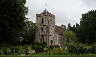
Turgis Green, Hants - geograph.org.uk - 445.jpg
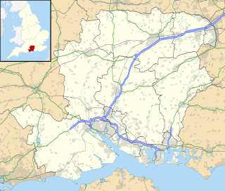
Hampshire UK location map.svg
Red pog.svg
Turgis Green
Location within Hampshire
OS grid reference SU6951359250
Civil parish
District
Shire county
Region
Country England
Sovereign state United Kingdom
Post town Hook
Postcode district RG27
Dialling code 01256
Police Hampshire
Fire Hampshire
Ambulance South Central
EU Parliament South East England
UK Parliament
Website Stratfield Turgis Parish Meeting
List of places
UK
England
Hampshire
51°19′39″N1°00′08″W / 51.3276°N 1.0022°W / 51.3276; -1.0022 Coordinates: 51°19′39″N1°00′08″W / 51.3276°N 1.0022°W / 51.3276; -1.0022

Turgis Green is a small hamlet in the civil parish of Stratfield Turgis in the English county of Hampshire. It is in the civil parish of Hartley Wespall. It contains six Grade II listed buildings and a Grade II listed milestone (on the A33). [1]

Hamlet (place) Small human settlement in a rural area

A hamlet is a small human settlement. In different jurisdictions and geographies, hamlets may be the size of a town, village or parish, be considered a smaller settlement or subdivision or satellite entity to a larger settlement. The word and concept of a hamlet have roots in the Anglo-Norman settlement of England, where the old French hamlet came to apply to small human settlements. In British geography, a hamlet is considered smaller than a village and distinctly without a church or other place of worship.

Stratfield Turgis human settlement in United Kingdom

Stratfield Turgis is a small village and civil parish in the north-east of the English county of Hampshire.

England Country in north-west Europe, part of the United Kingdom

England is a country that is part of the United Kingdom. It shares land borders with Wales to the west and Scotland to the north. The Irish Sea lies west of England and the Celtic Sea to the southwest. England is separated from continental Europe by the North Sea to the east and the English Channel to the south. The country covers five-eighths of the island of Great Britain, which lies in the North Atlantic, and includes over 100 smaller islands, such as the Isles of Scilly and the Isle of Wight.

Contents

Governance

The hamlet of Turgis Green is part of the civil parish of Stratfield Turgis, [2] and is part of the Pamber and Silchester ward of Basingstoke and Deane borough council. [3] The borough council is a Non-metropolitan district of Hampshire County Council.

Civil parish Territorial designation and lowest tier of local government in England

In England, a civil parish is a type of administrative parish used for local government, they are a territorial designation which is the lowest tier of local government below districts and counties, or their combined form, the unitary authority. Civil parishes can trace their origin to the ancient system of ecclesiastical parishes which historically played a role in both civil and ecclesiastical administration; civil and religious parishes were formally split into two types in the 19th century and are now entirely separate. The unit was devised and rolled out across England in the 1860s.

Basingstoke and Deane Borough and Non-metropolitan district in England

Basingstoke and Deane is a local government district and borough in Hampshire, England. Its primary settlement is Basingstoke. Other settlements include Bramley, Tadley, Kingsclere, Overton, Oakley, Whitchurch and the hamlet of Deane, some 7 miles (11 km) from Basingstoke.

Non-metropolitan district Type of local government district in England

Non-metropolitan districts, or colloquially "shire districts", are a type of local government district in England. As created, they are sub-divisions of non-metropolitan counties in a two-tier arrangement.

Transportation

The hamlet is situated on the northern section of the busy A33 road, which splits it north to south. It is not served by any public transport.

A33 road road in England

The A33 is a major road in England, situated in the counties of Berkshire and Hampshire. The road currently runs in three disjoint sections.

History

The hamlet is named for the Turgis family that owned land locally in the thirteenth century. Turgis Green was inclosed in 1866 as a result of the General Inclosure Act, [4] which permitted landlords to enclose open fields and common land and deny local people their historic rights to graze on these area, as well as wood gathering and water rights. Late in the eighteenth century it was proposed to build a cut (canal branch) from the Basingstoke Canal to Turgis Green but the proposal never came to fruition. [5]

The Inclosure Acts use an old or formal spelling of the word now more usually spelt "enclosure". They cover enclosure of open fields and common land in England and Wales, creating legal property rights to land that was previously held in common. Between 1604 and 1914, over 5,200 individual enclosure acts were passed, affecting 6.8 million acres.

Basingstoke Canal

The Basingstoke Canal is a British canal, completed in 1794, built to connect Basingstoke with the River Thames at Weybridge via the Wey Navigation.

Sport and leisure

The hamlet includes a cricket pitch, home of the Stratfield Turgis & Hartley Wespall Cricket Club, and small children's playground.

In the game of cricket, the cricket pitch consists of the central strip of the cricket field between the wickets. It is 22 yards long and 10 feet wide. The surface is flat and normally covered with extremely short grass though this grass is soon removed by wear at the ends of the pitch.

Playground Place with a specific design for children to be able to play there

A playground, playpark, or play area is a place specifically designed to enable children to play there. It is typically outdoors. While a playground is usually designed for children, some target other age groups. Berlin's Preußenpark for example is designed for people aged 70 or higher. A playground might exclude children below a certain age.

Religious Sites

Turgis Green is served by the church of St. Mary the Blessed Virgin, about a mile from the hamlet and close to the hamlet of Hartley Wespall.

Hartley Wespall village in Hampshire, England

Hartley Wespall is a civil parish in the Basingstoke and Deane district of Hampshire, England. It is near the larger village of Hook, which lies approximately 2.5 miles (4.1 km) south-west from the hamlet.

Related Research Articles

Old Basing village in the United Kingdom

Old Basing is a village in the English county of Hampshire. It is situated just to the east of Basingstoke, and in the 2001 census had a population of 7,232. Its former name is Basing.

Hannington, Hampshire village in the United Kingdom

Hannington is a civil parish in the English county of Hampshire. It is situated between Basingstoke and Newbury, on the North Hampshire Downs in the North Wessex Downs Area of Outstanding Natural Beauty. In the 2001 census it had a population of 332 people, increasing to 493 at the 2011 Census.

North Waltham human settlement in United Kingdom

North Waltham is a village and civil parish in the borough of Basingstoke and Deane in Hampshire, England. It is located around 6 miles (9.7 km) southwest of Basingstoke and just north of the M3 motorway. In the 2001 Census it had a population of 840. The village is home to a pond, shop, Victorian primary school, and recreation ground. The Church of England Parish Church is dedicated to St Michael.
Herriard village in the United Kingdom

Herriard is a village and civil parish in the Basingstoke and Deane district of Hampshire, England. Its nearest town is Basingstoke, which lies 4 12 miles (7.2 km) north. The village is situated mainly on the A339 road between Alton, and Basingstoke. At the 2001 census, it had a population of 247, increasing marginally to 251 at the 2011 Census. It was formerly served by the now-disused Herriard railway station on the Basingstoke and Alton Light Railway.
Bramley Green village in United Kingdom

Bramley Green is a small village in the civil parish of Bramley in the Basingstoke and Deane district of Hampshire, England. It lies approximately 4 miles (6.4 km) south-east from the village of Bramley.

Ibworth village in United Kingdom

Ibworth is a hamlet in Hampshire, England. It is in the civil parish of Hannington. Interesting features include a community notice board and a wall post box dating from the reign of Queen Victoria.

Inhurst village in United Kingdom

Inhurst is a hamlet in Hampshire, England. It is in the civil parish of Baughurst.

Pamber End village in United Kingdom

Pamber End is a hamlet in north Hampshire, England.

Plastow Green hamlet in United Kingdom

Plastow Green is a hamlet in north Hampshire, England.

Aldern Bridge village in United Kingdom

Aldern Bridge is a hamlet in Hampshire, United Kingdom. The settlement is within the civil parish of Burghclere, and is located approximately 2.3 miles (3.7 km) south-east of Newbury.

Ashley Warren village in Hampshire, England

Ashley Warren is a hamlet in the Basingstoke and Deane district of Hampshire, England. The settlement is within the civil parish of Ecchinswell, Sydmonton and Bishops Green, and is located approximately 7.3 miles (11.7 km) south of Newbury.

Axford, Hampshire village in Hampshire, United Kingdom

Axford is a hamlet in the Basingstoke and Deane district of Hampshire, England. The settlement is within the civil parish of Nutley, and is located approximately 5.5 miles (8.9 km) south-west of Basingstoke.

Southrope village in United Kingdom

Southrope is a hamlet in the civil parish of Herriard, Hampshire. It has one pub, named the Fur and Feathers. The hamlet was once considered a part of the civil parish Bentworth, until the late 19th century. Its nearest town is Alton, which lies approximately 5.8 miles (9.3 km) south-east from the hamlet. The hamlet's toponym derives from Old English Sūþrop, meaning south village.

Middle Wyke village in United Kingdom

Middle Wyke is a hamlet in the Basingstoke and Deane district of Hampshire, England. Its nearest town is Andover, which lies approximately 3.7 miles (6.1 km) south-west from the hamlet.

Newfound, Hampshire village in United Kingdom

Newfound is a hamlet in the Basingstoke and Deane district of Hampshire, England. Its nearest town is Basingstoke, which lies approximately 4.1 miles (6.6 km) east from the hamlet.

North Oakley village in United Kingdom

North Oakley is a hamlet in the civil parish of Hannington in the Basingstoke and Deane district of Hampshire, England. Its nearest town is Tadley, which lies approximately 6.4 miles (10.3 km) north-east from the village.

Brocks Green village in United Kingdom

Brock's Green is a small village in the Basingstoke and Deane district of Hampshire, England. Its nearest town is Newbury, which lies approximately 4.7 miles (7.6 km) north-west from the village.

References

  1. "British Listed Buildings". 2010. Retrieved 9 January 2010.
  2. "Hampshire County Council's legal record of public rights of way in Hampshire" (PDF). 2008. Retrieved 26 October 2010.
  3. "Basingstoke and Deane Wards info". 2010. Archived from the original on 24 October 2010. Retrieved 26 October 2010.
  4. "A History of the County of Hampshire: Volume 4". 1911. Retrieved 8 January 2011.
  5. "The History of the Basingstoke Canal" (PDF). 1973. Retrieved 1 January 2011.