Ocean Grove, Massachusetts

Last updated

Ocean Grove, Massachusetts
CDP
Happy Clam, Ocean Grove MA.jpg
Happy Clam
Bristol County Massachusetts incorporated and unincorporated areas Ocean Grove highlighted.svg
Location in Bristol County in Massachusetts
Coordinates: 41°43′44″N71°12′34″W / 41.72889°N 71.20944°W / 41.72889; -71.20944 Coordinates: 41°43′44″N71°12′34″W / 41.72889°N 71.20944°W / 41.72889; -71.20944
Country United States
State Massachusetts
County Bristol
Town Swansea
Area
[1]
  Total0.84 sq mi (2.17 km2)
  Land0.66 sq mi (1.71 km2)
  Water0.18 sq mi (0.45 km2)
Elevation
16 ft (5 m)
Population
 (2020)
  Total2,904
  Density4,386.71/sq mi (1,694.43/km2)
Time zone UTC-5 (Eastern (EST))
  Summer (DST) UTC-4 (EDT)
FIPS code 25-50880
GNIS feature ID0612642

Ocean Grove is a census-designated place (CDP) in the town of Swansea in Bristol County, Massachusetts, United States, on the north shore of Mount Hope Bay near the Cole River. The population was 2,811 at the 2010 census, and 2,904 as of the 2020 census. [2] [3]

Contents

Geography

Ocean Grove is located at 41°43′44″N71°12′34″W / 41.72889°N 71.20944°W / 41.72889; -71.20944 (41.728751, -71.209365). [4]

According to the United States Census Bureau, the CDP has a total area of 2.1 km2 (0.81 sq mi) of which 1.7 km2 (0.66 sq mi) is land and 0.4 km2 (0.15 sq mi) (18.29%) is water.

Demographics

Historical population
CensusPop.
2020 2,904
U.S. Decennial Census [5]

At the 2000 census, [6] there were 3,012 people, 1,234 households and 856 families residing in the CDP. The population density was 1,735.7/km2 (4,495/sq mi). There were 1,303 housing units at an average density of 750.9/km2 (1,945/sq mi). The racial makeup of the CDP was 97.28% White, 0.43% African American, 0.10% Native American, 0.27% Asian, 0.23% from other races and 1.69% from two or more races. Hispanic or Latino of any race were 0.37% of the population.

There were 1,234 households, of which 27.8% had children under the age of 18 living with them, 53.8% were married couples living together, 10.5% had a female householder with no husband present, and 30.6% were non-families. 26.5% of all households were made up of individuals, and 10.7% had someone living alone who was 65 years of age or older. The average household size was 2.44 and the average family size was 2.95.

20.8% of the population were under the age of 18, 7.3% from 18 to 24, 30.2% from 25 to 44, 25.6% from 45 to 64, and 16.1% who were 65 years of age or older. The median age was 40 years. For every 100 females, there were 96.6 males. For every 100 females age 18 and over, there were 90.6 males.

The median household income was $43,527 and the median female income was $50,777. Males had a median income of $36,919 and females $22,875. The per capita income was $20,007. About 6.6% of families and 7.7% of the population were below the poverty line, including 9.6% of those under age 18 and 14.9% of those age 65 or over.

Related Research Articles

Cypress Lakes, Florida Unincorporated place in Florida, United States

Cypress Lakes was a census-designated place (CDP) in Palm Beach County, Florida, United States. The population was 1,468 at the 2000 census.

Goodings Grove was a census-designated place in northern Will County, Illinois, United States. The population was 17,084 at the 2000 census. It ceased to exist as an entity upon the incorporation of the village of Homer Glen, Illinois in 2001.

Georgetown, St. Joseph County, Indiana Census-designated place in Indiana, United States

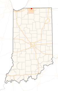
Georgetown is a census-designated place in Clay Township, St. Joseph County, in the U.S. state of Indiana. The population was 4,497 at the 2000 census. It is part of the South Bend–Mishawaka, IN-MI, Metropolitan Statistical Area.

North Seekonk, Massachusetts Census-designated place in Massachusetts, United States

North Seekonk is a census-designated place (CDP) in the town of Seekonk in Bristol County, Massachusetts, United States. The population was 2,643 at the 2010 census.

Raynham Center, Massachusetts Census-designated place in Massachusetts, United States

Raynham Center is a census-designated place (CDP) in the town of Raynham in Bristol County, Massachusetts, United States. The population was 4,100 at the 2010 census.

East Douglas, Massachusetts CDP in Massachusetts, United States

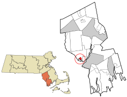
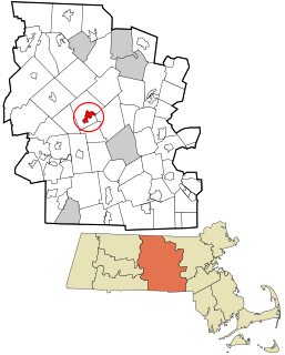
East Douglas is a census-designated place (CDP) in the town of Douglas in Worcester County, Massachusetts, United States. The population was 2,557 at the 2010 census.

Lyon Mountain, New York Census-designated place & hamlet in New York, United States

Lyon Mountain is a hamlet and census-designated place located in the town of Dannemora in Clinton County, New York, United States. The population was 423 at the 2010 census.

Beaverdam Lake–Salisbury Mills, New York Former census-designated place in New York, United States

Beaverdam Lake-Salisbury Mills was a census-designated place (CDP) in Orange County, New York, United States. It encompassed a region in the corner of the towns of Blooming Grove, Cornwall, and New Windsor. As of the 2000 census, its population was 2,779. For the 2010 census, the area was counted as two separate CDPs: Beaver Dam Lake in the towns of Blooming Grove and New Windsor and Salisbury Mills in the towns of Blooming Grove and Cornwall. Beaverdam Lake is also the name of a lake next to the community.

Pleasant Grove, Ohio CDP in Ohio, United States

Pleasant Grove is a census-designated place (CDP) in Muskingum County, Ohio, United States. The population was 2,016 at the 2000 census.

West Hill, Ohio CDP in Ohio, United States

West Hill is a census-designated place (CDP) in Trumbull County, Ohio, United States. The population was 2,523 at the 2000 census. It is part of the Youngstown–Warren–Boardman, OH-PA Metropolitan Statistical Area.

Shady Grove, Cherokee County, Oklahoma Census-designated place in Oklahoma, United States

Shady Grove is an unincorporated community and census-designated place (CDP) in Cherokee County, Oklahoma, United States. The population was 556 at the 2010 census. This is not to be confused with the similarly-named Shady Grove in McIntosh County, or the Shady Grove in Pawnee County.

Eyers Grove, Pennsylvania Census-designated place in Pennsylvania, United States

Eyers Grove is a census-designated place in Columbia County, Pennsylvania, United States. The population was 105 at the 2010 census. It is part of the Bloomsburg–Berwick Micropolitan Statistical Area.

Pymatuning South, Pennsylvania Census-designated place in Pennsylvania, United States

Pymatuning South is a census-designated place (CDP) in Crawford County, Pennsylvania, United States. The population was 479 at the 2010 census.

Harrisville, Rhode Island Census-designated place in Rhode Island, United States

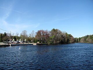
Harrisville is a census-designated place (CDP) and village in the town of Burrillville in Providence County, Rhode Island, United States. The population was 1,605 at the 2010 census. Much of the community composes a historic district listed on the National Register of Historic Places. The village was named after nineteenth century manufacturer Andrew Harris. Previously, the village was named Rhodesville, after Captain William Rhodes, an eighteenth century privateer.

Brush Prairie, Washington Census-designated place in Washington, United States

Brush Prairie is a census-designated place (CDP) in Clark County, Washington, United States. The population was 2,652 at the 2010 census, up from 2,384 at the 2000 census.

Cherry Grove, Washington Census-designated place in Washington, United States

Cherry Grove is a census-designated place (CDP) in Clark County, Washington, United States. The population was 546 at the 2010 census, down from 663 at the 2000 census.

MacArthur, West Virginia Census-designated place in West Virginia, United States

MacArthur is a census-designated place (CDP) in Raleigh County, West Virginia, United States. Originally, it was named Hollywood and renamed MacArthur in 1942. The population was 1,500 at the 2010 census.

Rutland (CDP), Massachusetts CDP in Massachusetts, United States

Rutland is a census-designated place (CDP) in the town of Rutland in Worcester County, Massachusetts, United States. The population was 2,111 at the 2010 census.

Spencer (CDP), Massachusetts CDP in Massachusetts, United States

Spencer is a census-designated place (CDP) in the town of Spencer in Worcester County, Massachusetts, United States. The population was 5,700 at the 2010 census.

Bar Harbor is a census-designated place (CDP) in the town of Bar Harbor in Hancock County, Maine, United States. The CDP population was 2,552 at the 2010 census, out of a population of 5,235 in the town of Bar Harbor as a whole.

References

  1. "2020 U.S. Gazetteer Files". United States Census Bureau. Retrieved May 21, 2022.
  2. "Profile of General Population and Housing Characteristics: 2010 Demographic Profile Data (DP-1): Ocean Grove CDP, Massachusetts". United States Census Bureau . Retrieved December 7, 2011.
  3. Bureau, US Census. "Search Results". The United States Census Bureau. Retrieved September 5, 2022.
  4. "US Gazetteer files: 2010, 2000, and 1990". United States Census Bureau. February 12, 2011. Retrieved April 23, 2011.
  5. "Census of Population and Housing". Census.gov. Retrieved June 4, 2016.
  6. "U.S. Census website". United States Census Bureau . Retrieved January 31, 2008.