Raynham Center, Massachusetts

Last updated

Raynham Center, Massachusetts
Johnson Pond, Raynham Center MA.jpg
Johnson Pond
Bristol County Massachusetts incorporated and unincorporated areas Raynham Center highlighted.svg
Location in Bristol County in Massachusetts
Coordinates: 41°55′55″N71°2′35″W / 41.93194°N 71.04306°W / 41.93194; -71.04306
Country United States
State Massachusetts
County Bristol
Town Raynham
Area
[1]
  Total4.34 sq mi (11.25 km2)
  Land4.22 sq mi (10.92 km2)
  Water0.13 sq mi (0.33 km2)
Elevation
39 ft (12 m)
Population
 (2020)
  Total4,365
  Density1,035.34/sq mi (399.76/km2)
Time zone UTC-5 (Eastern (EST))
  Summer (DST) UTC-4 (EDT)
ZIP code
02768
Area code 508 / 774
FIPS code 25-56095
GNIS feature ID0613137

Raynham Center is a census-designated place (CDP) in the town of Raynham in Bristol County, Massachusetts, United States. The population was 4,100 at the 2010 census. [2]

Contents

Geography

Raynham Center is located at 41°55′55″N71°2′35″W / 41.93194°N 71.04306°W / 41.93194; -71.04306 (41.931854, -71.043151). [3]

According to the United States Census Bureau, the CDP has a total area of 11.3 km2 (4.4 mi2), of which 11.0 km2 (4.3 mi2) is land and 0.3 km2 (0.1 mi2) (2.51%) is water.

Demographics

Historical population
CensusPop.Note
2020 4,365
U.S. Decennial Census [4]

As of the census [5] of 2000, there were 3,633 people, 1,235 households, and 1,037 families residing in the CDP. The population density was 329.3/km2 (852.5/mi2). There were 1,252 housing units at an average density of 113.5/km2 (293.8/mi2). The racial makeup of the CDP was 96.20% White, 1.05% African American, 0.03% Native American, 1.13% Asian, 0.08% Pacific Islander, 0.61% from other races, and 0.91% from two or more races. Hispanic or Latino of any race were 0.74% of the population.

There were 1,235 households, out of which 38.9% had children under the age of 18 living with them, 70.7% were married couples living together, 10.2% had a female householder with no husband present, and 16.0% were non-families. 13.0% of all households were made up of individuals, and 6.1% had someone living alone who was 65 years of age or older. The average household size was 2.94 and the average family size was 3.21.

In the CDP, the population was spread out, with 25.9% under the age of 18, 8.3% from 18 to 24, 28.7% from 25 to 44, 27.4% from 45 to 64, and 9.8% who were 65 years of age or older. The median age was 38 years. For every 100 females, there were 93.5 males. For every 100 females age 18 and over, there were 90.6 males.

The median income for a household in the CDP was $64,464, and the median income for a family was $66,531. Males had a median income of $43,718 versus $32,772 for females. The per capita income for the CDP was $24,131. About 3.7% of families and 2.3% of the population were below the poverty line, including 2.0% of those under age 18 and 4.9% of those age 65 or over.

Related Research Articles

<span class="mw-page-title-main">North Attleborough Center, Massachusetts</span> Former Census-designated place in Massachusetts, United States

North Attleborough Center is the central developed area in the town of North Attleborough in Bristol County, Massachusetts, United States. It was a census-designated place at the 2000 census, at which time its population was 16,796. It was not delineated as a census-designated place in 2010.

<span class="mw-page-title-main">North Seekonk, Massachusetts</span> Census-designated place in Massachusetts, United States

North Seekonk is a census-designated place (CDP) in the town of Seekonk in Bristol County, Massachusetts, United States. The population was 2,643 at the 2010 census.

<span class="mw-page-title-main">North Westport, Massachusetts</span> Census-designated place in Massachusetts, United States

North Westport is a census-designated place (CDP) in the town of Westport in Bristol County, Massachusetts, United States. The population was 4,571 at the 2010 census.

<span class="mw-page-title-main">Norton Center, Massachusetts</span> Census-designated place in Massachusetts, United States

Norton Center is a census-designated place (CDP) in the town of Norton in Bristol County, Massachusetts, United States. The population was 2,671 at the 2010 census.

<span class="mw-page-title-main">Middleborough Center, Massachusetts</span> Census-designated place in Massachusetts, United States

Middleborough Center is a census-designated place (CDP) in the town of Middleborough in Plymouth County, Massachusetts, United States. The population was 7,319 at the 2010 census.

<span class="mw-page-title-main">North Lakeville, Massachusetts</span> Census-designated place in Massachusetts, United States

North Lakeville is a census-designated place (CDP) in the town of Lakeville in Plymouth County, Massachusetts, United States. The population was 2,630 at the 2010 census.

<span class="mw-page-title-main">North Plymouth, Massachusetts</span> Census-designated place in Massachusetts, United States

North Plymouth is a census-designated place (CDP) in the town of Plymouth in Plymouth County, Massachusetts, United States. The population was 3,600 at the 2010 census. it is best known as the location of Cordage Park, a small village where the Plymouth Cordage Company was once headquartered. The village is now home to Cordage Commerce Center, a large retail development that consists of offices and stores.

<span class="mw-page-title-main">Wareham Center, Massachusetts</span> Census-designated place in Massachusetts, United States

Wareham Center is a census-designated place (CDP) in the town of Wareham in Plymouth County, Massachusetts, United States. The population was 2,896 at the 2010 census.

<span class="mw-page-title-main">West Wareham, Massachusetts</span> Census-designated place in Massachusetts, United States

West Wareham is a census-designated place (CDP) in the town of Wareham in Plymouth County, Massachusetts, United States. The population was 2,064 at the 2010 census.

<span class="mw-page-title-main">Harrisville, Rhode Island</span> Census-designated place in Rhode Island, United States

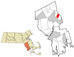
Harrisville is a census-designated place (CDP) and village in the town of Burrillville in Providence County, Rhode Island, United States. The population was 1,605 at the 2010 census. Much of the community composes a historic district listed on the National Register of Historic Places. The village was named after nineteenth century manufacturer Andrew Harris. Previously, the village was named Rhodesville, after Captain William Rhodes, an eighteenth century privateer.

<span class="mw-page-title-main">Valley Falls, Rhode Island</span> Village and census-designated place in Rhode Island, US

Valley Falls is a village and census-designated place (CDP) in the town of Cumberland, Providence County, Rhode Island, United States. The population was 12,094 at the 2020 census.

<span class="mw-page-title-main">Narragansett Pier, Rhode Island</span> CDP in Rhode Island, United States

Narragansett Pier is an unincorporated village and a census-designated place (CDP) in the town of Narragansett in Washington County, Rhode Island, United States. The population was 3,409 at the 2010 census.

<span class="mw-page-title-main">Wakefield-Peacedale, Rhode Island</span> CDP in Rhode Island, United States

Wakefield-Peacedale is a census-designated place (CDP) in the town of South Kingstown in Washington County, Rhode Island, United States that includes the villages of Peace Dale and Wakefield. The population was 8,487 at the 2010 census.

<span class="mw-page-title-main">Medfield (CDP), Massachusetts</span> CDP in Massachusetts, United States

Medfield is a census-designated place (CDP) in the town of Medfield in Norfolk County, Massachusetts, United States. The population was 6,483 at the 2010 census.

<span class="mw-page-title-main">Sharon (CDP), Massachusetts</span> CDP in Massachusetts, United States

Sharon is a census-designated place (CDP) in the town of Sharon in Norfolk County, Massachusetts, United States. The population was 6,184 at the 2020 census.

<span class="mw-page-title-main">Walpole (CDP), Massachusetts</span> Census-designated place in Massachusetts, United States

Walpole is a small census-designated place (CDP) located within the much larger town of Walpole in Norfolk County, Massachusetts, United States. Walpole Town as it is called by the US Census Bureau, also includes a much larger population. The population of the Census Designated Place was 5,918 at the 2010 census.

<span class="mw-page-title-main">Kingston (CDP), Massachusetts</span> Census-designated place in Massachusetts, United States

Kingston is a census-designated place (CDP) in the town of Kingston in Plymouth County, Massachusetts, United States. The population was 5,591 at the 2010 census.

<span class="mw-page-title-main">Lunenburg (CDP), Massachusetts</span> CDP in Massachusetts, United States

Lunenburg is a census-designated place (CDP) in the town of Lunenburg in Worcester County, Massachusetts, United States. The population was 1,760 at the 2010 census.

<span class="mw-page-title-main">Rutland (CDP), Massachusetts</span> CDP in Massachusetts, United States

Rutland is a census-designated place (CDP) in the town of Rutland in Worcester County, Massachusetts, United States. The population was 2,111 at the 2010 census.

<span class="mw-page-title-main">Webster (CDP), Massachusetts</span> CDP in Massachusetts, United States

Webster is a census-designated place (CDP) in the town of Webster in Worcester County, Massachusetts, United States. The population was 11,412 at the 2010 census.

References

  1. "2020 U.S. Gazetteer Files". United States Census Bureau. Retrieved May 21, 2022.
  2. "Profile of General Population and Housing Characteristics: 2010 Demographic Profile Data (DP-1): Raynham Center CDP, Massachusetts". United States Census Bureau . Retrieved December 7, 2011.
  3. "US Gazetteer files: 2010, 2000, and 1990". United States Census Bureau. February 12, 2011. Retrieved April 23, 2011.
  4. "Census of Population and Housing". Census.gov. Retrieved June 4, 2016.
  5. "U.S. Census website". United States Census Bureau . Retrieved January 31, 2008.