Victoria is the capital city of the Canadian province of British Columbia, on the southern tip of Vancouver Island off Canada's Pacific coast. The city has a population of 91,867, and the Greater Victoria area has a population of 397,237. The city of Victoria is the seventh most densely populated city in Canada with 4,406 inhabitants per square kilometre (11,410/sq mi).

Kensington is an area of London in the Royal Borough of Kensington and Chelsea, around 2.9 miles (4.6 km) west of Central London.

The West End of London is a district of Central London, London, England, west of the City of London and north of the River Thames, in which many of the city's major tourist attractions, shops, businesses, government buildings and entertainment venues, including West End theatres, are concentrated.

Golders Green is an area in the London Borough of Barnet in England. A smaller suburban linear settlement, near a farm and public grazing area green of medieval origins, dates to the early 19th century. Its bulk forms a late 19th century and early 20th century suburb with a commercial crossroads. The rest is of later build. It is centred approximately 6 miles (9 km) north west of Charing Cross on the intersection of Golders Green Road and Finchley Road.

Wood Green is a suburban district in the borough of Haringey in London, England. Its postal district is N22, with parts in N8 or N15. The London Plan identifies it as one of the metropolitan centres in Greater London, and today it forms a major commercial district of north London.

Stratford is a town in East London, England, within the London Borough of Newham. Part of the Lower Lea Valley, Stratford is situated 6 miles (9.7 km) east-northeast of Charing Cross, and includes the localities of Maryland and East Village.

A street is a public thoroughfare in a built environment. It is a public parcel of land adjoining buildings in an urban context, on which people may freely assemble, interact, and move about. A street can be as simple as a level patch of dirt, but is more often paved with a hard, durable surface such as tarmac, concrete, cobblestone or brick. Portions may also be smoothed with asphalt, embedded with rails, or otherwise prepared to accommodate non-pedestrian traffic.

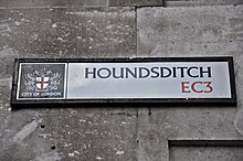
High Street is a common street name for the primary business street of a city, town, or village, especially in the United Kingdom and Commonwealth. It implies that it is the focal point for business, especially shopping. It is also a metonym for the retail sector.

Ryde is a suburb of Sydney, New South Wales, Australia. Ryde is located 13 km north-west of the Sydney central business district and 8 km east of Parramatta. Ryde is the administrative centre of the local government area of the City of Ryde and part of the Northern Sydney region. It lies on the north bank of the Parramatta River. People from Ryde are colloquially known as Ryders, Rydiens or Rydemen.

Chatswood is a major business and residential district in the Lower North Shore of Sydney, in the state of New South Wales, Australia, 10 kilometres north of the Sydney central business district. It is the administrative centre of the local government area of the City of Willoughby. It is often colloquially referred to as "Chatty".

Richmond is an inner-city suburb in Melbourne, Victoria, Australia, 3 km (1.9 mi) east of the Melbourne central business district, located within the City of Yarra local government area. Richmond recorded a population of 28,587 at the 2021 census, with a median age of 34.

Wortley is an inner city area of Leeds, West Yorkshire, England. It begins one mile to the west of the city centre. The appropriate City of Leeds ward is called Farnley and Wortley.

In landscaping, an avenue, alameda, or allée, is traditionally a straight path or road with a line of trees or large shrubs running along each side, which is used, as its Latin source venire indicates, to emphasize the "coming to," or arrival at a landscape or architectural feature. In most cases, the trees planted in an avenue will be all of the same species or cultivar, so as to give uniform appearance along the full length of the avenue.
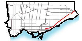
Kingston Road is a major arterial road in Toronto and Durham Region, Ontario. It the southernmost major (mainly) east-west road in the eastern portion of Toronto, specifically in the district of Scarborough, and runs east to Ajax in Durham. Until 1998, it formed a portion of Highway 2. The name of the street is derived from Kingston, Ontario as the road was the primary route used to travel from Toronto to the settlements east of it situated along the shores of Lake Ontario; in the west end of Kingston, the road was referred to as the York Road until at least 1908, and is today named Princess Street.

A street name is an identifying name given to a street or road. In toponymic terminology, names of streets and roads are referred to as odonyms or hodonyms. The street name usually forms part of the address. Buildings are often given numbers along the street to further help identify them. Odonymy is the study of road names.
A street suffix is the part of a street or road name that describes what type of road it is. Examples include "street", "avenue", "lane", "highway", and "drive". As they are commonly repeated between roads, they are often abbreviated; for example, "St." instead of "Street". The way street suffixes are used varies around the world.

A numbered street is a street whose name is an ordinal number, as in Second Street or Tenth Avenue. Such forms are among the most common street names in North America, but also exist in other parts of the world, especially in Colombia, which takes the system to an extreme, and the Middle East. Numbered streets were first used in Philadelphia and now exist in many major cities and small towns. Grid-based naming systems usually start at 1, and then proceed in numerical order. In the United States, seven out of the top ten most common street names are numbers, with the top three names being "2nd," "3rd," and "1st" respectively. Streets named "0th" are quite uncommon, however, but do exist, and negative numbered streets are extraordinarily rare. Fractional numbered streets exist in some places, such as 10+1⁄2 Street in Springfield, Illinois.

Epping is a market town and civil parish in the Epping Forest district of the county of Essex, England. The town is 17 miles (30 km) northeast from the centre of London, is surrounded by the northern end of Epping Forest, and on a ridge of land between the River Roding and River Lea valleys.