B roads are numbered routes in Great Britain of lesser importance than A roads. See the article Great Britain road numbering scheme for the rationale behind the numbers allocated.
B roads are numbered routes in Great Britain of lesser importance than A roads. See the article Great Britain road numbering scheme for the rationale behind the numbers allocated.
| Road | From | To | Notes | Length |
|---|---|---|---|---|
| B100 | Appold Street, near A501 Moorgate, London | A1 Barbican Underground station, London | Beech Street, Chiswell Street, Sun Street Sun Street is one-way westbound. | 0.4 miles (0.64 km) |
| B101 | A5201 Old Street, London | A1200 East Road, London | Pitfield Street, New North Road. Partly one-way northbound. Partly cycles only. | 0.4 miles (0.64 km) |
| B102 | A1200 New North Road, London | A104 Balls Pond Road, London | Southgate Road Originally ran along Bridport Place (now a path through Shoreditch Park). | 0.8 miles (1.3 km) |
| B103 (defunct) | A1201 St. Paul's Road, London | A104 Balls Pond Road, London | Now part of the A1199. | |
| B104 | A105 Newington Green, London | A10 in Stoke Newington, London | Albion Road, Stoke Newington Church Street | 1.1 miles (1.8 km) |
| B105 | A1201 in Finsbury Park near London | A10 in Stoke Newington near London | Brownswood Road, Lordship Park, Manor Road | 1.3 miles (2.1 km) |
| B106 | B550 in Muswell Hill near London | A406 in Bowes Park near London | Original route ran from the A553 to the A10/A107 in Stamford Hill; this was upgraded to a portion of the A107 early on. | 1.6 miles (2.6 km) |
| B107 (defunct) | A1203 in East Smithfield | West end of Wapping High Street | Declassified. | |
| B108 | A1203 in Shadwell, London | A104 junction in Dalston | Queensbridge Road, Warner Place, Squirries Street, Vallance Road, New Road and Cannon Street Road | 2.5 miles (4.0 km) |
| B109 | A118 Forest Gate | A124 East Ham | Original route ran from A107 to A104 in Hackney; this became a portion of the A107 when Mare Street was downgraded in the center of Hackney. | 1.2 miles (1.9 km) |
| B110 (defunct) | A104 in Hackney | A107 in Hackney | Became a portion of the A107 when Mare Street was downgraded in the center of Hackney. | |
| A1 in Holloway | A103/A503 in Holloway | Essentially an extension of the B516, which was on the other side of the A1; now a part of the A107. | ||
| B111 | A10, Stoke Newington, London | A107, Upper Clapton near rail station | Northwold Road | 0.6 miles (0.97 km) |
| B112 | A102 Homerton | A12 near Hackney Wick | Marsh Hill, Homerton Road | 0.8 miles (1.3 km) |
| B113 | A107 Hackney Central | A106 Homerton | Number also appears on maps on a section of downgraded A629 north of Sheffield; this is an error as the actual number is B6546. | 1.2 miles (1.9 km) |
| B114 (defunct) | B112 Homerton | B118 Old Ford | Section south of the B113 was upgraded to Class I status, possibly as the A102, by 1939; the northern half gained that number much later. The northern half was upgraded again to A102(M) in the 1970s, but was downgraded in the 2000s and is now the A12. | |
| B115 (defunct) | A107 South Hackney | A11 Leytonstone | Upgraded to Class I status in 1924 to bypass the A11 through Leytonstone and Stratford; the section west of the A112 became the A106 with the remainder gaining that number much later. Due to the A12, much of the original route was rerouted; the old route across the rail line is now severed and Church Lane declassified. | |
| B116 (defunct) | B114 Cadogan Gate | B113 Chapman Road | Later absorbed into the A115; much of route obliterated by the A12. | |
| B117 (defunct) | B115 (now A106) South Hackney | A11 Mile End | Upgraded to a portion of the A1205 in the 1970s. | |
| B118 | B142 near Bow | A1208 Shoreditch, London | Columbia Road, Gosset Street, Old Bethnal Green Road, Old Ford Road | 2.3 miles (3.7 km) |
| B119 | A107 Bethnal Green, London | A12 near Bow, London | Roman Road | 1.3 miles (2.1 km) |
| B120 | B119 Bethnal Green | A11 Stepney Green | Globe Road | 0.5 miles (0.80 km) |
| B121 | A11 near Stepney Green, London | A13 Limehouse, London | Stepney Green, Stepney High Street, Belgrave Street | 0.7 miles (1.1 km) |
| B122 | A10 Shoreditch High Street | A1209 Bethnal Green Road | Original route ran from the A11 to the A13 in Poplar; this was upgraded to Class I status in the 1930s, possibly as the A102, and was upgraded again to the A102(M) in the 1970s when the East Cross Route was built. Part of the original B122 still exists along St Leonards Street in Bow, but much of the route is now gone due to the motorway construction. The route is now part of the A12 when the motorway was downgraded in 2000. | 0.3 miles (0.48 km) |
| B123 (defunct) | A1205 in Poplar | B124 in Poplar | Declassified due to the A1261, which bypassed the route to the south. | |
| B124 (defunct) | A13 in Poplar | A1206 in Millwall | Became an extension of the A1206. | |
| B125 | A12 near Bow, London | A13 near Canning Town | Abbott Road | 0.7 miles (1.1 km) |
| B126 | A13 Limehouse, London | A1202 (Dock Street) near Tower Gateway DLR station | Cable Street | 1.1 miles (1.8 km) |
| B127 | A107 Cambridge Heath railway station | B118 near Bethnal Green | Bishops Way, Stewardstone Road | 0.6 miles (0.97 km) |
| B128 (defunct) | Moorgate, London | Aldersgate Steeet, London | Declassified. | |
| B129 (defunct) | Moorgate, London | Beech Street, London | Declassified. | |
| B130 (defunct) | Threadneedle Street, London | Liverpool Street, London | Declassified. | |
| B131 (defunct) | A3 in London | A1212/A1213 in London | Declassified. | |
| B132 (defunct) | A100 at Tower Hill, London | A3211 in London | Upgraded in the 1970s and renumbered as an extension of the A3211 in the 1990s. | |
| B133 (defunct) | B132 (now A3211) in London | B132 (now A3211) in London | Declassified. | |
| B134 | A1211 Aldgate, London | A1209 near Shoreditch | Alie Street, Osborn Street, Brick Lane | 1-mile (1.6 km) |
| B135 | A1209 Bethnal Green Road | A107 Cambridge Heath Road | Sclater Street, Cheshire Street, Dunbridge Street, Three Colts Lane | 0.8 miles (1.3 km) |
| B137 | A1010 Ponders End, London | A1055 near Angel Road railway station | Montagu Road, Nightingale Road | 1.8 miles (2.9 km) |
| B138 | B151 Wood Green, London | B150 near Harringay railway station | Wightman Road, Alroy Road | 1.4 miles (2.3 km) |
| B140 | B121 Stepney, London | A12 near Bow, London | Devas Street, Devons Road, St Pauls Way, Rhodeswell Road, Ben Jonson Road | 1.9 miles (3.1 km) |
| B141 (defunct) | A109 in London | A109 in London | Declassified. | |
| B142 | A11 Bow, London | B118 near Bow, London | Fairfield Road, Tredegar Road, Parnell Road | 0.6 miles (0.97 km) |
| B144 | B100 Moorgate, London | A1200 near Shoreditch Park, London | Eagle Wharf Road, Shepherdess Walk, Bath Street, Bunhill Row. | 1.1 miles (1.8 km) |
| B145 (defunct) | A13 in London | A102 in London | ||
| B146 | A110 near Chingford, London | A1009 near Woodford, London | Friday Hill | 0.5 miles (0.80 km) |
| unused | ||||
| B148 | A127 Dunton Wayletts | A176 in Basildon | West Mayne, St Nicholas Lane | 2.8 miles (4.5 km) |
| B149 | A1013 near Little Thurrock | A126 near Chadwell St Mary | Wood View, Chadwell Bypass | 1.4 miles (2.3 km) |
| B150 | A1201 near Finsbury Park, London | A105 near Seven Sisters, London | Woodstock Road, Florence Road, Upper Tollington Park, Endymion Road | 0.8 miles (1.3 km) |
| B151 | A109 near Wood Green, London | B138 near Wood Green, London | Hornsey Park Road, Mayes Road, Station Road, Park Avenue | 0.8 miles (1.3 km) |
| B152 | A105 in Harringay, London | A10 near Stamford Hill, London | St Ann's Road | 1.2 miles (1.9 km) |
| B153 | A504 in West Green, London | A10 near Seven Sisters, London | Philip Lane | 0.8 miles (1.3 km) |
| B154 | A105 near Winchmore Hill, London | A1010 in Edmonton, London | Church Road | 1.4 miles (2.3 km) |
| B155 | A109 between Wood Green, London and Tottenham, London | A504 in Seven Sisters, London | Belmont Road, Downhills Way | 0.9 miles (1.4 km) |
| B155 (defunct) | A110 in East Barnet | A1005 south of Potters Bar | Upgraded to an extension of the A111 by 1926. The original northern end of this B155 is now gone due to M25 junction 24. | |
| A105 in Wood Green, London | A109 in Wood Green, London | Renumbered as a portion of the A1080 in the 1970s. The current B155 is not far from this route. | ||
| B156 | A1000 near Potters Bar | A10 near Cheshunt | 8.1 miles (13.0 km) | |
| B157 | A1000 near Brookmans Park | B156 in Cuffley | Plough Hill, The Ridgeway, Shepherds Hill | 3.3 miles (5.3 km) |
| B158 | A602 near Tonwell, Hertfordshire | A1000 near Potters Bar, Hertfordshire | The B158 originally started from the A10 at Wadesmill, but since the opening of the High Cross bypass, has been truncated. | 10.9 miles (17.5 km) |
| B159 | A112 in Leyton, London | A104 in Leyton, London | Leyton Green Road | 0.3 miles (0.48 km) |
| B160 | A104 / A114 Whipps Cross - near Leytonstone, London | A110 near Chingford, London | Wood Street, Fulbourne Road, Winchester Road and Larkshall Road | 3.6 miles (5.8 km) |
| B161 | A114 in Forest Gate, London | A112 near Leyton, London | Dames Road, Harrow Road, Cathall Road, Francis Road | 1.4 miles (2.3 km) |
| B162 (defunct) | A11/A115 in Leytonstone | A114 in Wanstead | Became a portion of the A114 when it was rerouted, possibly in the early 1930s. | |
| A118 in Romford | A125 in Romford | Now part of A125 and A1251. | ||
| B163 (defunct) | B113 in Stratford, London | Stratford Market railway station | Section north of the A11 absorbed into the A115 and the southern section was declassified. | |
| B164 | A11 near Stratford, London | B165 West Ham, London | Vicarage Lane | 0.4 miles (0.64 km) |
| B165 | A112 West Ham, London | A118 Manor Park, London | Densham Road, Portway, Plashet Road, Plashet Grove, East Avenue, Browning Road, Church Road, Little Ilford Lane | 3.4 miles (5.5 km) |
| B167 | A118 Upton Park, London | A117 East Ham, London | Green Street, Central Park Road, Cheltenham Gardens, Rancliffe Road | 2.1 miles (3.4 km) |
| B168 | A11 in South Woodford, London | A113 South Woodford, London | George Lane, The Viaduct and Daisy Road | 0.6 miles (0.97 km) |
| B169 | A110 Chingford, London | A112 near Chingford, London | Original route was a loop off the A11 (now A104) to serve Loughton; this was renumbered as an extension of the A121 in the mid-1920s. | 0.6 miles (0.97 km) |
| B170 | A121 Buckhurst Hill, Essex | A113 Chigwell, Essex | 2 miles (3.2 km) | |
| B171 (defunct) | A113 near Chigwell, Essex | A121 near Loughton | Renumbered to A1168, possibly when the M11 was built and M11 junction 5 (Loughton Interchange) put in. | |
| B172 | A104/A121 Wake Arms Roundabout, near Loughton Essex | A113 Abridge,Essex | 3.5 miles (5.6 km) | |
| B173 | A113 Woodford Bridge, London | A1112 Chigwell Row, Essex | 2.7 miles (4.3 km) | |
| B174 | A1112 near Collier Row, London | A12 near Mawneys, London | Formerly went to A113; this section north of A1112 became part of an extended A1112. | 2.3 miles (3.7 km) |
| B175 | B174 near Romford, London | A113 Passingford Bridge, Essex | 5.5 miles (8.9 km) | |
| B176 | A1170 Turnford near Cheshunt, Hertfordshire | A121 Waltham Cross near Cheshunt, London | Original route ran from Ilford to Beacontree Heath; this was upgraded to the A1083 in 1925. | 2.7 miles (4.3 km) |
| B177 | A124 Barking, London | A12 Goodmayes, London | Passes Goodmayes railway station | 2.2 miles (3.5 km) |
| B178 | A1112 Dagenham East, London | A1306 Dagenham, London | Formerly went north to what is now A1240; this became part of rerouted A1112. | 0.8 miles (1.3 km) |
| B179 | A112 Walthamstow, London | A503 Walthamstow, London | Original route ran from Hoddesdon to Stanstead St Margaret's; this was upgraded to Class I status as a spur of the A10 in 1935 and later renumbered A1032, then downgraded to an extension of the B180, and downgraded again in the 1980s to Class III status as the C43 when the roads at both ends were upgraded. | 1.9 miles (3.1 km) |
| B180 | B181 Stanstead Abbotts, Hertfordshire | B1004 Widford, Hertfordshire | 3.8 miles (6.1 km) | |
| B181 | A1170 Stanstead St. Margarets, Hertfordshire | A414 Tyler's Green, Essex | 13.6 miles (21.9 km) | |
| B182 | B181 near Epping | B1393 Epping | 1.3 miles (2.1 km) | |
| B183 | A414 Harlow, Essex | B1256 Takeley, Essex | 9.8 miles (15.8 km) | |
| B184 | A128/A414 Chipping Ongar, Essex | M11/A11/A1301 Ickleton, Essex | 30.4 miles (48.9 km) | |
| B185 | A1023 Brentwood | B186 Brentwood near Rail Station | 0.2 miles (0.32 km) | |
| B186 | A128 Brentwood | A1306 West Thurrock | 11.4 miles (18.3 km) | |
| B187 | B186 Cranham, London | A124 Upminster, London | 2 miles (3.2 km) | |
| B188 | A1013,Thurrock | A128 near Orsett,Thurrock | 3 miles (4.8 km) | |
| B189 | A126 Grays | Thames Road/Argent Street Roundabout | 0.3 miles (0.48 km) | |
| B190 (defunct) | A1 (now B197)/B653 in Stanborough | A1 in Lemsford | The eastern side became a portion of the A1000 in the 1970s with the southern section now A6129 and the northern now B195. | |
| B191 | A1083 Green Lane, London | A124 Longbridge Road, Dagenham, London | Bennett's Castle Lane | 0.8 miles (1.3 km) |
| B192 | A123 Gants Hill, London | A1400 near Gants Hill, London | Beehive Lane | 0.7 miles (1.1 km) |
| B193 | A1000 Great North Road, Barnet, London | A110 East Barnet, London | Longmore Avenue | 1-mile (1.6 km) |
| B194 | A1170 Broxbourne, Hertfordshire | A121 Waltham Abbey, Essex | Connects Lower Nazeing with A roads | 5.9 miles (9.5 km) |
| B195 | A1000 near Welwyn Garden City | A414 Cole Green | 2.2 miles (3.5 km) | |
| B196 (defunct) | A11 | B174 | Became part of an extended A1112. | |
| B197 | B656, Baldock | A6129/A1(M)/B653 | Breaks along A602 through Stevenage | 10.4 miles (16.7 km) |
| B198 | A47 near Wisbech | A47 near Wisbech | This is the old A1135, which replaced part of the A47 when the bypass opened in 1984. Road number is also in use near Cheshunt (see below). | 4.5 miles (7.2 km) |
| B198 | A10 / A121 junction near Waltham Cross | B156 in Goff's Oak near Cheshunt | The Cheshunt Southern Relief Road, formerly part of the A121 and renumbered around the time this section of the M25 was completed. Road number is duplicated in Wisbech (see above) with both still being in use. | 1.8 miles (2.9 km) |
| B199 | B1003 | A15 in Lincoln | This is the old A57 renumbered in 2017 because the A57 was rerouted south. Road number is also in use near Cheshunt. | 4.5 miles (7.2 km) |
| Road | From | To | Notes | Length |
|---|---|---|---|---|
| B1000 | A1000 at Welwyn Garden City | A119 at Hertford | 4.3 mi (6.9 km) | |
| B1001 | A10 at Ware | A1170 at Ware | ||
| B1002 | Brentwood | Near Chelmsford | Original route of the A12; the original B1002 went from Bishop's Stortford to Ware, and is now part of the B1004 | |
| B1003 | Lincoln College | Far Wharf | Originally South Street in Bishop's Stortford, upgraded to A1059, now B1529. Formerly had a second section from the B1273 Brayford Way to the A1434 Newark Road until 2017, when this section was renumbered as the A1192. The sections connected via Wigford Way, Brayford Wharf East, and Rope Walk until the late 1990s. | |
| B1004 | Ware | Bishop's Stortford | Section south of what is now the A1250 was the B1002 | |
| B1005 (defunct) | Bishop's Stortford | Hatfield Heath | Upgraded to the A1060 in the 1960s. | |
| B1006 | A13 in South Benfleet | B1014 in Benfleet | Original route ran from A122 in Writtle to the A414; upgraded to A1091 by 1927, became a part of A414 between 1978 and 1982 and declassified in 1986 | |
| B1007 | Stanford-le-Hope | Chelmsford | ||
| B1008 | Chelmsford | Dunmow | The section from Little Waltham to Dunmow was downgraded from the A130. | |
| B1009 | Chelmsford | Galleywood | ||
| B1010 | A414 Woodham Mortimer | Burnham on Crouch | ||
| B1012 | South Woodham Ferrers | B1010 near North Fambridge | Connecting the B1010 with A132 | |
| B1013 | Rayleigh Church | A127 Prittlewell ('Tesco' roundabout) | To A127 (The Bell) via Rochford prior to 1996 | |
| B1014 | Canvey Island Leigh Beck | A13 between Hadleigh and Thundersley | ||
| B1015 | Westcliff on Sea | Southend on Sea | ||
| B1016 | A1160 Southend on Sea | Shoeburyness | ||
| B1017 | A13 near North Shoebury | Great Wakering | ||
| B1018 | Southminster | Braintree | ||
| B1019 | Hatfield Peverel | Langford | ||
| B1020 (defunct) | Althorne | Southminster | Renumbered as an extension of B1018 in the 1980s. | |
| B1021 | Burnham on Crouch | Bradwell Waterside | ||
| B1022 | Heybridge | Colchester | ||
| B1023 | near Kelvedon | Tollesbury | ||
| B1024 | Kelvedon | Earls Colne | ||
| B1025 | Colchester | West Mersea | crosses from the mainland to Mersea Island by way of The Strood which is covered by the sea at the time of high spring tides. | |
| B1026 | B1022 at Heybridge | A133 in Colchester | Original B1026 ran between the A12 and A133; upgraded to A1040 in 1924, later downgraded to B1422; now A134 | 15.4 mi (24.8 km) |
| B1027 | A133 south of Colchester | A133 at Clacton-on-Sea | by way of Alresford, Thorrington, Great Bentley and St Osyth | 12.1 mi (19.5 km) |
| B1028 | B1027 at the University of Essex | Wivenhoe | ||
| B1029 | Jc 30 of the A12 near Stratford St Mary | Brightlingsea | by way of Dedham, Ardleigh, Great Bromley, Frating, Great Bentley and Thorrington | 14.1 mi (22.7 km) |
| B1030 (defunct) | Connected railway station (now demolished) with B1029 in Brightlingsea town centre. Now a spur of B1029. | |||
| B1031 (defunct) | Pier Avenue (then A133) in Clacton-on-Sea | Clacton-on-Sea railway station | via Station Rd | |
| B1032 | Clacton-on-Sea | Kirby Cross | ||
| B1033 | A133 at Weeley | Frinton-on-Sea | ||
| B1034 | B1033 southeast of Thorpe-le-Soken | Walton-on-the-Naze | ||
| B1035 | B1352 southeast of Manningtree | B1033 northwest of Thorpe-le-Soken | By way of Horsleycross Street, Horsley Cross, Tendring Green, Goose Green and Tendring | |
| B1036 | west of Laindon | south of Laindon | Original route ran along West Street in Harwich from A135 to the Quay; this is now part of B1352. | |
| B1037 | northeast of Stevenage | Cottered | ||
| B1038 | Buntingford | Newport, Essex | ||
| B1039 | Royston | Wendens Ambo | ||
| B1040 | Biggleswade | Crowland | ||
| B1041 | A1 Little Paxton | St Neots | Original route ran along The Baulk between A1 (now A6001) and B1040; this is now a spur of B1040. | |
| B1042 | Sandy, Bedfordshire | A1198 near Wendy, Cambridgeshire | ||
| B1043 | A1(M) at Alconbury | A1(M)/A15 at Norman Cross | Former portion of the A1. | |
| B1044 | A141 northwest of Huntingdon | A1307/A1198 Godmanchester | ||
| B1045 (defunct) | A132 (now A1307) in Cambridge | Cambridge railway station | Declassified. | |
| B1046 | Eynesbury | A603 near Barton | ||
| B1047 | A1303 in Barnwell | A14 in Fen Ditton | ||
| B1048 | St Neots | north of Eaton Ford | ||
| B1049 | A1134 in Cambridge | A1123 at Wilburton | 10.9 mi (17.5 km) | |
| B1050 | A14 at Bar Hill | A141 at Chatteris | 17.2 mi (27.7 km) | |
| B1051 | Stansted Mountfitchet | Great Sampford | ||
| B1052 | B1061 near Burrough Green | Wendens Ambo | ||
| B1053 | Saffron Walden | A131 north of Braintree | ||
| B1054 | B1053 east of Radwinter | A1017 | ||
| B1055 | B1053 | B1054 at Hempstead, Essex | ||
| B1056 (defunct) | B1054 in Steeple Bumpstead | B1057 in Steeple Bumpstead | ||
| B1057 | Great Dunmow | Haverhill | ||
| B1058 (defunct) | Sible Hedingham | A131 | ||
| B1059 (defunct) | Colchester | Sudbury | Upgraded to the A133, but later downgraded again; now B1508. | |
| A45 | A45 | Much of route now B1075. | ||
| B1060 (defunct) | Haverhill | Bury St Edwards | Extended over the B1067 probably around 1935; much of route became A143 in the 1950s, remaining section declassified | |
| B1061 | A1017 east of Haverhill | Newmarket | ||
| B1062 | A143 at Homersfield | Beccles | Originally ran along the River Stour from Baythorne End to Long Melford; upgraded to the A1092 in the early 1920s. | |
| B1063 | Clare | Newmarket | 16.3 mi (26.2 km) | |
| B1064 | A131 north of Sudbury | A1092 north of Long Melford | ||
| B1065 | A1092 (Melford Road) | B1066 near Glemsford | ||
| B1066 | A143 south of Bury St Edmunds | A1092 north of Long Melford | by way of Whepstead, Brockley, Cross Green and Hartest | |
| B1067 | Bramford | Ipswich | Originally ran from A45 to A134 in Bury St Edmunds; renumbered as a portion of B1060 in 1935. One section now A1302, the remainder is unclassified. | 3 mi (4.8 km) |
| B1068 | A134 at Leavenheath | A12 near East Bergholt | ||
| B1069 | A1152 at Rendlesham | B1078 at Tunstall | Originally ran from the A134 near Newton to the A12 in Ipswich; this was upgraded to the A1071 in 1924. Parts of the route are now unclassified, including the entire section east of the current A14. | 1.4 mi (2.3 km) |
| B1070 | A137 at Cattawade near Manningtree | Hadleigh, Suffolk | The B1070 originally continued northwards from here towards Bury St Edmunds. This is now the A1141. | |
| B1071 | A1141 at Lavenham | B1115 near Little Waldingfield | ||
| B1072 (defunct) | Holbrook Hall | Bildeston | Renumbered as a portion of the B1115 in 1935; original multiplex with the B1070 through Monks Eleigh is now a multiplex with the A1141. | |
| Coates | Guyhirn | Intended as a more direct route between Whittlesey and Guyhirn; became a portion of the A605 in the 1960s when it was extended. | ||
| B1073 | B1098 near Christchurch, Cambridgeshire | A1101 at Welney | 4.2 mi (6.8 km) | |
| B1074 | St Olaves | A1117 north-west of Lowestoft | Originally ran from the A12 near Copdock to the A45 at Great Blankenham. Renumbered to A1100 early on; much of route now B1113, although the section immediately north of Copdock is unclassified. | |
| B1075 | A1214 in Ipswich | A1156 in Ipswich | 3.2 mi (5.1 km) | |
| B1076 | B1075 in Ipswich | A1156 in Ipswich | 0.3 mi (0.48 km) | |
| B1077 | B1108 at Carbrooke | A1156 in Ipswich | 43.6 mi (70.2 km) | |
| B1078 | Bildeston | B1084 northwest of Orford | ||
| B1079 | Helmingham Hall | Woodbridge | ||
| B1080 | A137 east of Brantham | B1456 | Original route ran from the A12 in Martlesham to the then-A139 (now unclassified), bypassing Ipswich to the east. Renumbered to A1093 by 1928, but is now unclassified due to construction of the A12 bypass of Ipswich. | 5.4 mi (8.7 km) |
| B1081 | A1 near Tickencote | A1 near Carpenters Lodge | Old routing of A1 through Stamford; the original B1081 connected the A139 to itself in Felixstowe, this became a portion of A45 when it was extended. Now part of the A154. | |
| B1082 | A1021 | A154 | Originally ended at the seafront; later extended to the A154. | |
| B1083 | A1152 at Woodbridge | Bawdsey | by way of Sutton, Shottisham and Alderton | |
| B1084 | A1152 east of Woodbridge | Orford | by way of Butley and Chillesford | |
| B1085 | B1063 north of Lidgate | B1102 east of Fordham | 10.5 mi (16.9 km) | |
| B1086 | B1050 in Somersham | B1040 | Former portion of A141. | |
| B1087 | A134 west of Nayland | B1068 in Stoke-by-Nayland | Route into Nayland is former A134. The original B1087 ran from Haddenham to Witcham Toll, and was upgraded to Class I status in the early 1920s as the A1072. In 1935 it was renumbered as a spur of the A1123, but was later renumbered again, to A1421. | |
| B1088 (defunct) | A10 in Ely | A142 in Ely | Declassified when the A142 was rerouted around Ely. Now part of C317 and C318. | |
| B1089 | B1040 in Pidley | B1086 in Somersham | Originally ran along The Lane in Old Hurst, from B1040 to the A141. When the A141 was rerouted in 1935, the B1089 was extended along old A141 to the B1086 in Somersham. The section between Old Hurst and the rerouted B1040 was declassified when the A141 Old Hurst bypass was built. | 0.9 mi (1.4 km) |
| B1090 | B1043 near Sawtry | A1123 at Houghton, Cambridgeshire | Originally was to the north of the current route, from the A1 near Glatton to the B1040 in Ramsey St Mary's. The number was moved to the current route in 1935, and the original route became part of the B660. | 9.9 mi (15.9 km) |
| B1091 | A15 in Yaxley | A605/A1139/B1092 in Stanground | 3.5 mi (5.6 km) | |
| B1092 | A605/A1139/B1091 in Stanground | A605 at Horsey Hill | Original route was adjacent to the current one, from B1093 in Old Fletton to A605. The section east of the A15 is now part of the A1129 and the section west is unclassified. | 1.2 mi (1.9 km) |
| B1093 | A605 in Whittlesey | B1100 | Section from Whittlesey to the A15 became a portion of the A605 in 1935. | 21.1 mi (34.0 km) |
| B1094 | B1098 on the bank of the Sixteen Foot Drain | A1122 in Nordelph | Original route ran along the northern section of Church Street in Whittlesey, from the B1093 (now A605) to the B1040. Renumbered as a spur of the B1040, probably in 1935 as the number was reused that year. | 5.4 mi (8.7 km) |
| B1095 | A605 near Stanground | B1040 at Pondersbridge | 4.0 mi (6.4 km) | |
| B1096 | B1040 in Ramsey | B1093 in Benwick | 5.7 mi (9.2 km) | |
| B1097 (defunct) | B1040/B1093 in Whittlesey | A141 near March | The section from Whittlesey to just east of Coates is now part of the A605, the remainder is unclassified. | |
| B1098 | B1050 in Chatteris | A1101 at Three Holes | 12.4 mi (20.0 km) | |
| B1099 | A141 near March | B1098 | Route into March is former A141. | 5.5 mi (8.9 km) |
| B1100 | B1098 near Christchurch, Cambridgeshire | A1101 at Welney | 4.2 mi (6.8 km) | |
| B1101 | A141 at Wimblington | A1101 at Elm, Cambridgeshire | Section from March to Wimblington is former A141 | 11.1 mi (17.9 km) |
| B1102 | A1303 in Stow cum Quy, near Cambridge | A1101 in Mildenhall | 17.5 mi (28.2 km) | |
| B1103 | B1102 in Burwell | A142 in Newmarket | 4.5 mi (7.2 km) | |
| B1104 | B1382 in Prickwillow | B1085 at Chippenham, Cambridgeshire | by way of Isleham | 9 mi (14 km) |
| B1105 | Wells-next-the-Sea, Norfolk | Fakenham, Norfolk | Locally called the 'Dry Road', due to it being the only route in Norfolk not to have a pub on it. Originally the route went from Wells-next-the-Sea, through Wighton, Little Walsingham, Houghton St. Giles and East Barsham, on to Fakenham, but was re-classified with a parallel route circa 2002. | |
| B1106 | Brandon, Suffolk | Bury St. Edmunds, Suffolk | 14.2 mi (22.9 km) | |
| B1107 | Brandon, Suffolk | Thetford, Norfolk | 4.9 mi (7.9 km) | |
| B1108 | A1065 near Bodney | A147 in Norwich | 29.1 mi (46.8 km) | |
| B1109 (defunct) | A11 in Thetford | B1111 (now A1066) | Declassified. | |
| B1110 | A148 at Holt, Norfolk | A47 at Hockering | 19 mi (31 km) | |
| B1111 | A143 in Stanton | A1075 | Originally ran further north to the B1110, this section is now the A1075. Original route ran between Thetford and Diss, but when it was decided that the road between two of the main places in south Norfolk should be a Class I road, it was renumbered to A1066 in the early 1920s. | 4.2 mi (6.8 km) |
| B1112 | Stoke Ferry, Norfolk | Icklingham | 20.9 mi (33.6 km) | |
| B1113 | Sproughton | Norwich | ||
| B1114 (defunct) | Stowmarket | B1115 in Ashfield Place | Renumbered as a portion of B1115 in 1935. The section west of Stonham Aspal became a portion of the A1120 in the 1950s and the remainder declassified. The western end was renumbered back to B1115 when the A1120 was clipped back to the A45 (now A14). | |
| B1111 near Garboldisham | B1113 in Kenninghall | Declassified. | ||
| B1115 | A131 at Sudbury | A1120 at Stowupland | Small spur section runs between Bildeston, Suffolk and the A1141 in Semer, Suffolk away from main route, serving as a Hadleigh-Bildeston Road. | |
| B1116 | Lower Hacheston | Harleston | ||
| B1117 | A144 at Halesworth | A140 at Thornham Parva | 21.3 mi (34.3 km) | |
| B1118 | B1116 Dennington | A140 south of Diss | ||
| B1119 | Leiston | Saxtead Green | ||
| B1120 | Framlingham | Badingham | ||
| B1121 | A12 in Kelsale (near Saxmundham) | A1094 near Friston | ||
| B1122 | A12 near Yoxford | A1094 in Aldeburgh | ||
| B1123 | B1116 near Harleston | A145 near Blythburgh | ||
| B1124 | B1123 in Halesworth | A145 in Brampton | ||
| B1125 | B1122 near Theberton | A12 in Blythburgh | ||
| B1126 | A12 in Wangford | A1095 in Reydon | ||
| B1127 | A1095 in Reydon | A146 near Worlingham | ||
| B1128 (defunct) | A146 in Beccles | Beccles railway station | Became a portion of A145 when it was extended. | |
| B1129 (defunct) | A146 at Oulton Broad | A12 near Blundeston | Due to its importance, it was upgraded to Class I status as the A1117 in the 1930s. Much of route now the B1375 with only the southernmost section still numbered as A1117. | |
| B1130 (defunct) | B1129 (now A1117) in Oulton Broad | A12 in Lowestoft | Was the easternmost Class II road in the UK; upgraded to Class I status as the A1144 in the 1960s. The westernmost section is now part of a rerouted A1117. | |
| B1131 | B1188 near Canwick | A15 in Bracebridge Heath | 1.4 mi (2.3 km) | |
| B1132 (defunct) | B1111 in Roydon | B1131 in Diss | Became a loop off the A1066 in the 1920s, swapped with the A1066 in the 1970s. Declassified in the 2000s. | |
| B1133 | B181 near Broadley Common | A1169 in Great Parndon, Harlow | ||
| B1134 | B1077 between Short Green and New Buckenham | A143 near Redenhall | ||
| B1135 | A1075 near Toftwood | B1113 between Bracon Ash and Wreningham | ||
| B1136 | Hales, A146, Close to Loddon | Haddiscoe, A143 | Norfolk | |
| B1137 | A12 in Hatfield Peverel | A1099 in Chelmsford | Formerly A12 before construction of 3-lane dual carriageway | |
| B1138 (defunct) | A147 in Norwich | A1024 in Norwich | Declassified when the A1024 was extended clockwise, bypassing the B1138. The southernmost section is now part of the A147. | |
| A149 in Great Yarmouth | B1143 in Great Yarmouth | Declassified sometime after the 1990s. | ||
| B1139 (defunct) | St Martin's Road in Norwich | Riverside Road in Norwich | Bypassed Norwich to the north and east. One section was declassified in the 1920s along with the B1138. The remainder was upgraded to the A1067 in the 1960s. | |
| B1140 | A1151 at Wroxham | Cantley | Number previously assigned to a secondary route between Norwich and Reedham via Acle. A section of the old route within Norwich remains numbered as the B1140. | |
| B1141 | A1243 in Great Yarmouth | A1243 in Great Yarmouth | Although the termini are just under a quarter of a mile apart, the route is six times that distance in length. | |
| B1142 (defunct) | Beccles Road in Gorleston | Quay Road in Gorleston | The western section became a portion of a rerouted A12 (now B1370) before WWII and the eastern section was declassified in the 1990s. | |
| B1143 (defunct) | South Quay (A1243) | A12/A47 in Great Yarmouth | Declassified. | |
| B1144 | A148 (London Road in Kings Lynn) | A148 between Kings Lynn and Gaywood | ||
| B1145 | A149 at Kings Lynn | Mundesley | ||
| B1146 | Fakenham | A47 near Dereham | Has 3 ending in Fakenham, at the A1065 Hempton, the A1065/A148 roundabout and the A1067 Pensthorpe Road roundabout | 13.2 mi (21.2 km) |
| B1147 (defunct) | A47 near Dereham | A1067 near Bawdeswell | Downgraded to the C888 in 2015. | |
| B1148 (defunct) | A147 (now A1402) near Norwich | A148 in Fakenham | Upgraded to Class I status very early on due to its importance, and is now the A1067. | |
| A151 in Spalding | B1165 in Spalding | Became a spur of the B1165 in 1935, declassified in the 2000s following the construction of the A16 Spalding bypass. | ||
| A148 in Kings Lynn | A1078 in Kings Lynn | Declassified sometime after the 2000s. | ||
| B1149 | A148, Holt | A140, north of Norwich | The only direct route between Norwich and Holt | |
| B1150 | A1151 at Norwich | A149 at North Walsham | Previously continued beyond North Walsham to Bacton | |
| B1151 (defunct) | B1150 in Norwich | A149 in Smallburgh | Upgraded to Class I status in 1935, keeping the same number. | |
| A149 in Stalham | B1159 in Ingham | Declassified in the 2000s when the section of B1159 it connected to was also declassified. | ||
| B1152 | A1064 in Billockby | A149 in Bastwick | Splits near Billockby; route to Bastwick is the original 1922 route, other branch was created in 1935 and also meets the A149, but further south and a shorter distance. Before the 2000s, it continued to the now-declassified B1159. | |
| B1153 | A47 north of Narborough | A149 in Brancaster | Originally was Hillington to Docking; extended on both ends in the 1920s. | |
| B1154 (defunct) | A148 in Kings Lynn | A148 in Kings Lynn | Loop off A148 to serve Kings Lynn railway station; now part of the A148. | |
| B1155 | B1153 Docking Road/Snettisham Road in Great Bircham | A149 at Holkham | The road splits in Stanhoe, a branch leading to Docking and one to Great Bircham | |
| B1156 | A149 at Blakeney | A148 at Sharrington | Links A148 inland to the A149 coast road | 5 mi (8.0 km) |
| B1157 (defunct) | Sheringham | A148 above Upper Sheringham | Section north of the A148 gone by the mid-1970s and remainder declassified in the 2000s. | |
| East Dereham | Etling Green | Number reserved for the section of old A47 through East Dereham after the bypass opened, but the number was never used. The B1146 and B1147 were extended over the route instead. | ||
| B1158 (defunct) | A148 near Sheringwood | B1157 in Sheringham | Originally existed only north of the A149 and was extended to the A148 in 1935. This extension was upgraded to the A1082 in the early 1970s with the original route declassified. | |
| B1159 | A149 near Stalham, Norfolk | Paston, Norfolk | Formerly the number assigned to the Norfolk coastal road between Cromer and Great Yarmouth much of which is now downgraded to a C-road. | 7.5 mi (12.1 km) |
| B1160 | A10 | Roundabout at the A134 | Original route ran from B1145 and B1159 in Mundesley; half the route became B1159 in the early 1930s. A map from 1936 shows the route as a spur of the B1145, though it could have been declassified earlier. Entire route now declassified. | |
| B1161 | A149 in Hunstanton | A149 in Hunstanton | Loop off A149 | |
| B1162 | Roundabout on the A15 in Lincolnshire near Northborough | Deeping St James | ||
| B1163 (defunct) | A16 (now B1525) in Deeping St James | B1040 in Crowland | Became an extension of the B1166 in 1935. | |
| Brimsdown railway station | A110 | Renumbered to A1055. | ||
| B1164 | Markham Moor Roundabout on the A1 | Carlton-on-Trent | Used to be part of the A1 until the current A1 highway was built. Number is out-of-zone (located in Zone 6) due to rerouting of the A1. | |
| B1165 | Spalding | A1101 in Cambridgeshire | ||
| B1166 | B1169 at Leverington Common | B1525 at Market Deeping | 22.3 mi (35.9 km) | |
| B1167 | Thorney | B1166 near Throckenholt in Cambridgeshire | The part through Thorney used to be part of the A47 before the village was bypassed. | |
| B1168 | Holbeach | Holbeach Drove | ||
| B1169 | B1166 | A1101 near Wisbech | ||
| B1170 (defunct) | Wisbech East railway station | A47 (now A1101) in Wisbech | Declassified by 1968. | |
| B1171 (defunct) | A141 (now A47) in Wisbech | B1170 in Wisbech | Downgraded to a Class III road as the C28 by 1968. | |
| B1172 (defunct) | North End in Wisbech | Leverington Road in Wisbech | Renumbered as a portion of the A1101 in the 1960s. | |
| B1172 | A roundabout on the A16 north of Spalding | A roundabout on the A16 south of Spalding | Used to be part of the A16 through Spalding until the bypass was built. - Duplicated number see next | |
| B1172 | Junction with the A11 at Suton south of Wymondham | Junction with the A11 and A47 at Thickthorn, south of Norwich | Used to be part of the A11 through Wymondham and Hethersett until the bypass was built. - Duplicated number see previous. | 8.8 mi (14.2 km) |
| B1173 | Spalding | A roundabout with the A16 and A1073 | Used to be the northern part of the A1073 until the A16 bypass was built. | |
| B1174 | A roundabout on the A1 north of Grantham | Merges with the A1 at Little Ponton | Used to be part of the A1 through Granthan before the bypass was built. | |
| B1175 (defunct) | A16 in Spalding | A1 in Colsterworth | Section from Colsterworth to the new A1 renumbered as a portion of the B676 when Colsterworth was bypassed in the 1920s. The section east of the A15 was upgraded to a section of the A151 in the early 1930s and the remainder from the A1 to the A15 also became a portion of the B676 in 1935. Except for a small section west of the A1 Colsterworth bypass, the route is now part of the A151, although it now bypasses Bourne with the original route through Bourne becoming the B1193. | |
| B1176 | Ryhall | A roundabout with the A52 east of Grantham. | ||
| B1177 | A15 north of Morton in Lincolnshire. | A52 at Bridge End, Lincolnshire. | ||
| B1178 | Harmston | Potter Hanworth | ||
| B1179 (defunct) | New Road in Spalding | Bridge Street in Spalding | Connected the A16 with itself; declassified sometime after the 1960s. | |
| B1180 | Pinchbeck | Pinchbeck West | ||
| B1181 | Bicker | Drayton | ||
| B1182 | A15 near Lincoln | A46 near Lincoln | Former A46 and A1102; original route ran from West Street to High Street in Boston; this is now the A52 relief road. The eastern section was declassified and has been cut off from the remainder of the road. | |
| B1183 | Boston | Horncastle | ||
| B1184 | Old Leake | B1192 in Lincolnshire | ||
| B1185 (defunct) | A17/A1 in Newark-on-Trent | North Gate railway station | Unclassified, probably when the A46 Western Bypass opened. | |
| B1186 (defunct) | A46 (now B6166) near Newark-on-Trent | A156 in Torksey Lock | Upgraded to Class I status as the A1133 in the late 1960s. | |
| B1187 | A47 in Guyhirn | B1166 | Original route ran from Beckingham to Crowle; this was upgraded to Class I status as the A161 in the early 1930s. | |
| B1188 | Lincoln | A153 between Ruskington and Sleaford | ||
| B1189 | Metheringham | Billinghay | ||
| B1190 | A57 near Saxilby in Lincolnshire | Horncastle | ||
| B1191 | A15 north of Sleaford, Lincolnshire | A158 in Horncastle, Lincolnshire | ||
| B1192 | B1191 at Woodhall Spa | B1397 at Kirton, Lincolnshire | 20 mi (32 km) | |
| B1193 | A151 in Bourne | A151 in Bourne | Former routing of A151 | |
| B1193 (defunct) | Newland | Newport | Due to its importance, it was upgraded to Class I status as a portion of the A1102 Lincoln bypass, but was downgraded to the B1273 following the construction of the A46 bypass. The number was also assigned to St Mary's Street between the-then A15 and B1188 (now A15). This road was not classified until the mid-1920s, so it is unknown if the two routes existed concurrently or was allocated afterwards. This B1193 was renumbered to A1190 when the A15 was rerouted, later becoming the eastern section of the A57 and is currently the B199. | |
| B1194 (defunct) | A15 in Lincoln | A157 in Lincoln | Declassified, possibly when the A15 was rerouted over the western section of the A157 to avoid the center of Lincoln. | |
| B1195 | A158 east of High Toynton, Lincolnshire | Wainfleet All Saints | ||
| B1196 | Alford | A roundabout with the A158 and A1028 west of Gunby | ||
| B1197 | Hertford, Hertfordshire | A1170 in Hoddesdon, Hertfordshire | The London Road south from Hertford, so called as it provided the main link with the A10 to London. Formerly designated as part of the A602, it was renumbered with the opening of the current A10 route in the late 1970s. | |
| B1197 (defunct) | A16/A1028 in Ulseby Cross | B1196 in Alford | Upgraded to the A1104 in the early 1920s when Mabelthorpe needed a Class I road. | |
| A1104 near Alford | B1198 (later A154, now A52) | Upgraded to the A1111 in the 1960s. | ||
| B1198 | A177 in Shincliffe | A181 in Sherburn | Former section of A180; original route ran along the Lincolnshire coast from Old Clee to Skegness. The northern section was renumbered A1098 and B1401 (now A1031) in the early 1920s. The route south of Mabelthorpe became the A154 (later A52) by 1932; the remainder disappeared after WWII, becoming a portion of the A1031. Out-of-zone in County Durham because the original A1 (now the A167), not the A1(M), forms the zone boundary. | |
| B1199 (defunct) | A1084? in Brigg | A1084 in Brigg | Possibly connected the A1084 to itself; declassified in 1922, probably following construction of the present A18 bypass. | |
| B1200 | A157/A16 west of Louth | A1031 in Saltfleetby | Until the opening of the Louth bypass in 1991, the B1200 started at Kenwick Top, south of Louth, where the A16, A157 and B1520 now meet. | |
| B1201 | A16 at North Thoresby | A1031 south of Tetney | 2.4 mi (3.9 km) | |
| B1202 | Boothby Graffoe | Market Rasen | ||
| B1203 | Grimsby | Market Rasen | ||
| B1204 | Elsham | South Ferriby | Originally linked the A631 to the A46, allowing traffic to avoid Market Rasen (now the A1103). | |
| B1205 | Blyton | Nettleton | ||
| B1206 | B1205 just outside Kirton in Lindsey | New Holland | The part from Redbourne to New Holland used to be the northern part of the A15 before the current A15 was built. | |
| B1207 | B1206 at Hibaldstow | A1077 near Winteringham | 12.1 mi (19.5 km) | |
| B1208 | Brigg | B1207 north of Broughton | ||
| B1209 | A15 near Leasingham | A153 at Leasingham Moor | Original route ran from A15 (now A18) in Brigg to then-A46 in Caistor; this was upgraded, becoming the A1084 by 1926. | |
| B1210 | Grimsby | Kirmington | ||
| B1211 | Keelby | A18 east of Melton Ross, North Lincolnshire | ||
| B1212 | B1213 near Grimsby town centre | B1444 in the suburbs of Grimsby | ||
| B1213 | Roundabout with the A16 and A180 near Grimsby Docks | A46 in the suburbs of Cleethorpes | ||
| B1214 | A16 (now A1243) in Grimsby | A16 in Grimsby | Connected the A16 to itself; declassified sometime after the 1990s. | |
| B1215 | B1214 in Grimsby | A16 in Grimsby | Still had Class II status in the 1990s (may or may not have had the B1215 number), but was declassified sometime after that. | |
| B1216 | A1077 outside Scunthorpe | Gunness | ||
| B1217 | J47 of the M1 | Towton | Westernmost section was A642 until the M1 link was built, putting the number out-of-zone. | |
| B1218 | An interchange with the A15 and B1206 | Barton upon Humber | ||
| B1219 | Waltham | Humberston | ||
| B1220 | A638 near Woodlands | A1 in Skellow | ||
| B1221 | A174 (now B1380) in Ormesby | A171 in Ormesby | Declassified. | |
| B1222 | Fulford | A63 near Garforth | ||
| B1223 | A19 at Selby | A162 near Towton | 11.2 mi (18.0 km) | |
| B1224 | Wetherby | York | Out-of-zone in County Durham because the old A1 (now the A167), not the A1(M), forms the zone boundary. | |
| B1225 | Baumber | Caistor | ||
| B1226 | A15/A46 north of Lincoln | B1273 in Lincoln | Formerly a portion of A15 before the A15 Lincoln bypass was built. Original route ran from A19 to the A64 in York, which has since been declassified and pedestrianized. | |
| B1227 | Rougier Street, York | Tower Street, York | Route intersects the A1036 at either end as it loops around York city centre. | |
| B1228 | A64/A1079 near York | Boothferry, East Riding of Yorkshire | ||
| B1229 | A165 near Reighton, North Yorkshire | Ends in Flamborough, East Riding of Yorkshire | Originally allocated to the direct route between Howden and Holme-on-Spalding-Moor. Became a portion of the A1041 (now the A614). | |
| B1230 | Howden | Beverley | The section from Howden to the M62 was originally part of the A63. | |
| B1231 | Kingston upon Hull | North Ferriby | ||
| B1232 | A164 north of Willerby | A1105 at Hessle | ||
| B1233 | A164 at Skidby | A1079/A1165 in Kingston upon Hull | ||
| B1234 (defunct) | Hull docks | Carr Lane (likely the A63) in Hull | Declassified in the 1970s; the northernmost section is now gone, with a department store built on the site. Another section was wiped out by the A63/A1079 interchange. | |
| B1235 (defunct) | A63 in Hull | A165 in Hull | Renumbered to A1163 in the 1970s; the Brook Street section was upgraded to the A1079 and the eastern section of George Street along with North Bridge and Witham are now part of the A165. | |
| B1236 | Queen Victoria Square in Hull | B1235 in Hull | Declassified and pedestrianized sometime after the 1980s. | |
| B1237 | A1033 Stoneferry | A165 through Sutton on Hull | 3.1 mi (5 km) | |
| B1238 | A165 near Bilton, East Riding of Yorkshire | B1242 at Aldbrough, East Riding of Yorkshire | 7.9 mi (12.7 km) | |
| B1239 | Bilton, East Riding of Yorkshire | Preston, East Riding of Yorkshire | ||
| B1240 | Sproatley, East Riding of Yorkshire | Thorngumbald, East Riding of Yorkshire | ||
| B1241 | Lea | Saxilby | Originally allocated to a route from the A1033/B1240/B1241 in Hedon to the B1242 in Patrington (now the A1033). The western end is now part of the B1240. | |
| B1242 | Withernsea | Lissett | ||
| B1243 | Skirlaugh | Sigglesthorne | ||
| B1244 | Hornsea | A165 at Leven, East Riding of Yorkshire | Redesignated part of A1035 in 2013 | |
| B1245 (defunct) | crosswords in Leven | Hornsea Road in Leven | Declassified (along with a section of B1244) in 1994 when the A165 Leven bypass opened. | |
| B1246 | Barmby Moor | A614 north of Bainton, East Riding of Yorkshire | ||
| B1247 | A1079 | Pocklington | ||
| B1248 | A64 near Malton | A1035 near Cherry Burton | Passes through Norton-on-Derwent, North Grimston, Wharram-le-Street, Wetwang, Tibthorpe, Bainton | 27.1 mi (43.6 km) |
| B1249 | Skipsea | A64 at Staxton | ||
| B1250 | B1249 in Great Driffield | A166 in Great Driffield | Decommissioned in 1983. | |
| B1251 | Fridaythorpe | Sledmere | ||
| B1252 | Garton on the Wolds | Sledmere | ||
| B1253 | Bridlington | B1248 near North Grimston | ||
| B1254 | Bridlington town centre | B1255 in the suburbs of Bridlington. | ||
| B1255 | Bridlington | Flamborough north landing. | ||
| B1256 | Braintree | M11 J8 near Bishop's Stortford | First used on a route between the A19 in Thirsk and the A169 in Pickering (now part of the A170). The second use was the northern bypass of Darlington (now the A1150). | |
| B1257 | Stokesley | Malton | ||
| B1258 | A64 near West Knapton, North Yorkshire | Snainton | ||
| B1259 | Flamborough | Flamborough Head | ||
| B1260 | B1284 at Rainton Bridge, Houghton-le-Spring | B1404 at New Town, Houghton-le-Spring | 1 mi (1.6 km) | |
| B1261 | East Ayton | Lebberston | Section through Seamer originally part of the A64. | |
| B1262 (defunct) | A57 (now B199) Wigford Way / St Mary's Street | A1434 St Catherine's | Declassified in 2017. | |
| B1263 | Scorton | Low Entercommon | ||
| B1264 | A167 near Great Smeaton | Yarm | ||
| B1265 | B1264 (Yarm) | A67 (Yarm) | ||
| B1266 | A171 Newton Mulgrave Moor | A174 north of Mickleby | ||
| B1267 (defunct) | A173 in Skelton | A174 south of Marske-by-the-Sea | Upgraded to Class I status as portions of A173 and A174 in 2000 when the Skelton/Saltburn/Brotton bypass was built. | |
| B1268 | A173 at Upleatham Bridge | A174 at Corngrave | Originally ran to Saltburn, this section became part of the A174 in 2000. Remainder possibly downgraded to a C road (although OS maps still show it as a Class B road west of the Four Lanes End junction) sometime after 2009. | |
| B1269 | Near Guisborough | Redcar | ||
| B1270 (defunct) | Westbourne Grove in North Ormesby | Smeaton Street in North Ormesby | Declassified. | |
| B1271 (defunct) | A176 in Middlesbrough | A171 in Middlesbrough | Extended west to the A174 and east to the A171; the western extension became the A1130 (now A1032) in 1935 and was later clipped back to the B1272 with a small section becoming part of the B1272; remainder has since been declassified. | |
| B1272 | B6541 in Middlesbrough | A66 | ||
| B1273 | A57 Carholme Road | B1182 Nettleham Road | Continued south along Brayford Way to the B1003 (now A1192) Tritton Road until 2017 when the A57 was diverted along this section. Number originally allocated to a road east of Darlington from the A67 to the A19 (now A135). Renumbered to A67 in the 1960s; the westernmost section is now the B6280. | |
| B1274 | A177 in Roseworth, Stockton-on-Tees | A139 in Stockton-on-Tees | ||
| B1275 | A1027 near Billingham | A1046 in Haverton Hill | Originally routed along Chiltons Avenue, but was rerouted to the north in the 1920s after an industrial site was built. | |
| B1276 | A689 in Owton Manor, Hartlepool | A178 | ||
| B1277 | B1376 in Hartlepool | A178 in Graythorp | Originally a link between the A179 and A689 but has since been extended at both ends. | |
| B1278 | Sedgefield | Near Wheatley Hill | ||
| B1279 | A181 west of Thornley | B1280 | Parallels the A181 for much of its length. | |
| B1280 | A19 in Sheraton | A182 in South Hetton | ||
| B1281 | A19 west of Castle Eden | A1086 in Blackhall Colliery | ||
| B1282 (defunct) | Quarryheads Lane in Durham | A1050 (now A77) in Durham | Declassified; unknown why this number was chosen. | |
| B1283 | A181 at Sherburn, County Durham | A1086 at Horden | 10.1 mi (16.3 km) | |
| B1284 | Chester-le-Street Chilton Moor | Woodstone Village Hetton-le-Hole | Merged with A1052 between Woodstone Village and Chilton Moor. Continues as B1285. Out-of-zone due to the original A1 (now the A167), not the A1(M), forming the zone boundary. | |
| B1285 | Hetton-le-Hole | Seaham | ||
| B1286 | Ryhope | Philadelphia | ||
| B1287 | Seaham | Murton | ||
| B1288 | A167 in Birtley | A184 in Wardley | ||
| B1289 | Southwick Gyratory (A1231)) | Monkwearmouth Gyratory (A1018) | ||
| B1290 (defunct) | B1289 in Southwick | A183 in Bishopwearmouth | Upgraded to Class I status as the A1231, although the section over the Queen Alexandra Bridge is now the B1539. | |
| B1291 | Southwick | Seaburn | ||
| B1292 | A172 | A173 near Great Ayton | Originally allocated to a route from the A19 (now the A1018) to the Sunderland docks; became a portion of A183 when the Durham Coast Road was built. Part of the route is now unclassified and the remainder now gone. | |
| B1293 | A1231 at Sunderland | Hudson Dock | ||
| B1294 | A1018 at Sunderland | Extension Road, Sunderland | ||
| B1295 (defunct) | A183 in Bishopwearmouth | Ryhope Road in Sunderland | Much of the Stockton Road section became part of the A1231 (the southern end is part of a gyratory) and the remainder was declassified. | |
| A1/A167 at Eighton Lodge | B1296 in Wrekenton | Now a spur of the B1296. | ||
| B1296 | A1 in Low Eighton | A167 in Gateshead | Originally allocated to a route east of Gateshead from the A1 to the A184 in Heworth, now unclassified. The new B1296 actually crosses the old B1296. | |
| B1297 | A185 in Hebburn | A185 in Jarrow | Splits in Jarrow to serve the northern and southern sides of town. | |
| B1298 | South Shields | Roundabout just east of Testos Roundabout (A19), joining A184 | ||
| B1299 | Whitburn, Tyne and Wear | East Boldon | Middle section intersected by A1018 (Sunderland Road) | |
| B1300 (defunct) | A185 in South Shields | A19 in South Shields | Now part of an extension of the B1301. | |
| A185 (now A194) near the Tyne Dock | A183 above Marsden Bay | Eastern half now part of the A1300 and the remainder unclassified. | ||
| B1301 | South Shields | A1300 at Marsden, Tyne and Wear | 2.8 mi (4.5 km) | |
| B1302 | A194 at Tyne Dock | Harton Road | Hudson Street, Boldon Lane, | 0.6 mi (0.97 km) |
| B1303 | A194 at South Shields | B1344 | Part of Station Road | 0.2 miles (0.32 km) |
| B1304 | A192 near A1058 junction | A193 at North Shields | Originally ran from the Swing Bridge at the-then A184 to the A186; may have been renumbered B6634 because it was out-of-zone, but is now part of the B1600. | 1.0 mi (1.6 km) |
| B1305 | West Road A186 | Scotswood Road A695 | Condercum Road, Atkinson Road, Whitehouse Road | 0.9 mi (1.4 km) |
| B1306 | Leam Lane A194 | Victoria Road West A185 | Mill Lane | 1.0 mi (1.6 km) |
| B1307 | A184 at Gateshead | A1058 at Newcastle upon Tyne | Percy Street, St Mary's Place, Sandyford Road | 1.2 mi (1.9 km) |
| B1308 | Wragby Road A1434 | B1273 | Originally ran in Newcastle upon Tyne from the A186 to the A695. Now part of the B1600. | |
| B1309 | A167(M)/ A193 junction | John Dobson Street | Formerly ran between West Jesmond and Newcastle upon Tyne. Now part of the B1600. | 0.2 mi (0.32 km) |
| B1310 | A1 (now B1318) | B1309 (now B1600) | Declassified. | |
| B1311 | B1305 | Westgate Road A186 | 1.3 mi (2.1 km) | |
| B1312 | A188/ A193 in Byker | A193 in Byker | ||
| B1313 | B1312 in Byker | A186 in Walker | ||
| B1314 | B1313 at Welbeck Road | A186 at St Anthony's | ||
| B1315 | A193 in Wallsend | A193 in Howdon | ||
| B1316 | A191 Rake Lane | A1058/ A1108 | ||
| B1317 | B1322 in Backworth | B1505 in Forest Hall | ||
| B1318 | B1307 in Newcastle upon Tyne | A19/A1068 at Seaton Burn | ||
| B1319 | A1171/ A19 in Cramlington | A189/ A1056 in Killingworth | ||
| B1320 | A19 at Peterlee Roundabout | A1086 Coast Road | ||
| B1321 | A189/ A190 | Bridge Street/Front Street B1318 | 2.1 mi (3.4 km) | |
| B1322 | A191 | A190 Annitsford Road/Main Street South | 3.2 mi (5.1 km) | |
| B1323 (defunct) | A193 in Whitley Bay | A192 in Monkseaton | Declassified in the 1980s. | |
| B1324 (defunct) | B1323 in Monkseaton | A193 in Whitley Sands | Declassified in the 1980s, although the eastern end is now part of the A193. | |
| B1325 | A192 at Earsdon, Tyne and Wear | A193 at Hartley, Northumberland | 2.5 mi (4.0 km) | |
| B1326 | A1171 in Cramlington | A192 northwest of Seaton Delaval | by way of East Cramlington | |
| B1327 | B1328 Bridge Street | B1523 Plessey Road A193 Broadway/Rotary Way | 0.7 mi (1.1 km) | |
| B1328 | B1329/Quay Road junction | A193 Renwick Road | 0.5 mi (0.80 km) | |
| B1329 | A193 outside Blyth | A193 in northern Blyth | From the south to the north end of Blyth | 2.4 mi (3.9 km) |
| B1330 | A1068 in Red Row | B6345 in Togston | Former portion of A1068; originally ran from the A194 (now A193) in Bebside to the A196 in Stakeford. The southern section was declassified in 1961 due to completion of the Kitty Brewster Bridge over the River Blyth east of the Furnace Bridge, and the B1330 was moved onto this route to Bedington Station. In 1970 or 1971 the route was extended north to Stakeford Road. The route over the bridge was renumbered to A189 in 1975; the remainder was upgraded to Class I status as the A1147. | |
| B1331 | A192 west of Bedlington, Northumberland | A189 east of Bedlington | passes through Bedlington | |
| B1332 | A146 at Trowse south-east of Norwich | A143 at Ditchingham | formerly numbered as part of the A144 north of Bungay | |
| B1333 | A168 Thirsk Road A167 South Parade/East Road | Northallerton High Street | ||
| B1334 | A197 Woodhorn Lane in Newbiggin-by-the-Sea | A196 Newbiggin Road/North Seaton Road | ||
| B1335 | A1306 at Rainham | B186 at South Ockendon | Two sections linked by A1306 | 4.6 mi (7.4 km) |
| B1336 | B1033 in Frinton-on-Sea | B1034 in Walton-on-the-Naze | ||
| B1337 | A197/Morpeth Northern Bypass junction | A1068 | ||
| B1338 | Northumberland Street, Alnmouth | A1068 | ||
| B1339 | B1340 Lamberts's Lane | A1068 | ||
| B1340 | Bondgate Without B6346, Alnwick Town Centre | B1341 Front Street/B1342 Church Street, in Bamburgh | ||
| B1341 | A1 between Adderstone and Warenford | Front Street B1340/Church Street B1342 | ||
| B1342 | A1 near B6349 | Front Street B1340/B1341 | ||
| B1343 | B1347, near B1377 | A6137 near Ballencriff | ||
| B1344 | A183 Sea Road | ASDA South Shields Superstore/B1303 | ||
| B1345 | B1377 in Drem | A198 in Dirleton | ||
| B1346 | Loop off A198 in North Berwick | |||
| B1347 | A198 in North Berwick | A199 opposite A1 | ||
| B1348 | A199/B6454 | A198 near Longniddery | ||
| B1349 | B1348 High Street | B1361 Gardiner Terrace | ||
| B1350 | A1 in Edinburgh | A900 in Edinburgh | Anomalously numbered: this part of London Road is wholly within Zone 9 | |
| B1351 | Stansted Mountfitchet | B1383, Stansted Mountfitchet | ||
| B1352 | A137 at Lawford | A120 at Harwich | 12.6 miles (20.3 km) | |
| B1353 | B1069 Leiston Road | The Sanctuary, Thorpeness | ||
| B1354 | A148 at Thursford | B1149 at Saxthorpe, then restarts at A140 Hainford and finishes at A1151 Hoveton | Road has been re-routed since Saxthorpe/Corpusty by-pass construction | |
| B1355 | A148 Between Sculthorpe, and Fakenham | A149 Between Burnham Market and Burnham Norton | ||
| B1356 | A152 near A16 | A151 in Spalding | ||
| B1357 | Barrier Bank near A16 Cowbit Road | A17 Washway Road | ||
| B1358 (defunct) | A17 in Holbeach Clough | A17 in Fleet Hargate | De facto bypass of Holbeach; became part of A17 by the end of WWII (old A17 became B1168 and A151). A mile of the route is still A17 while the remainder was downgraded to Class III status as the C774. | |
| A160/A18 in Ulceby | Immingham Docks | Upgraded to a rerouted A160 in 1969; route west of Ulceby now part of a rerouted B1211 and the portion between Ulceby and the new A160 now part of a rerouted A1077 after the current A160 was built. | ||
| B1359 | A17 near Gedney, Lincolnshire | Gedney Drove End | by way of Gedney Dyke | |
| B1360 (defunct) | B1262 (now local road) High Street | B1003 (now A1192) Tritton Road | Declassified in 2017. | |
| B1361 | A199/ A6094 junction in Walleyford | A198/B6371 junction | ||
| B1362 | Hedon, East Riding of Yorkshire | Withernsea, East Riding of Yorkshire | ||
| B1363 | A1036 Gillygate/Lord Mayor's Walk, York | B1257 Leysthorpe Lane | ||
| B1364 | A64 near Scarborough railway station | A165 Columbus Ravine, Scarborough | ||
| B1365 | A174/ A1032 at Bluebells Corner | A172 Stocking Hill | ||
| B1366 | A174 West Road/Zetland Road | A171 | ||
| B1367 (defunct) | A13 (now A124) in Barking | A123 in Barking | Declassified when the Barking Ring Road was built. | |
| B1368 | A10 near Puckeridge | A10 in Harston | In Harston, the B1368 and not the A10 carries the name of London Road, despite both routes heading for London. Similarly milestones along the route offer distances to London. | 19.4 mi (31.2 km) |
| B1369 | A133 Wellesley Road | B1442 Centenary Way | ||
| B1370 | Stone Cross Roundabout - A143 Beccles Road | A47 in Gorleston-on-Sea | ||
| B1371 (defunct) | A17 at Swinesheads Bridge | A154 (now A52) at the Chain Bridge, Boston | Due to the route's importance, it was upgraded to Class I status as the A1121 in the late 1950s. | |
| B1372 (defunct) | A18 (now A46) in Cleethropes | A1098 in Cleethropes | Declassified. | |
| A16 in Spilsby | A158 west of Scremby | Upgraded to the A1115, but was downgraded again in 1986 and is now unclassified. | ||
| B1373 | A1104 | A157 | ||
| B1374 | A1098 Taylor's Avenue/Queen's Parade | A1098 Isaac's Hill/High Street | ||
| B1375 | A47 Yarmouth Road | A1117 Normanston Drive/Bridge Road | ||
| B1377 | A198 Main Street/Lyars Road | B1407 Bridge End | ||
| B1378 | Roundabout on A46 Lincoln ring road south of Skellingthorpe | B1003 at Boultham | Straight for nearly its entire length | |
| B1379 | A11 (now B1383) in Great Chesterford | A505 in Duxford | Declassified in 1980 due to construction of the M11, which paralleled the route. | |
| B1380 | Bluebells Corner - A1032 | Greystones Roundabout - A174/ A1053 | ||
| B1381 | A142 Mepal Road/Ely Road | A1123/B1050 | ||
| B1382 | Ely | A1101 near Shippea Hill | ||
| B1383 | A1184, Bishop's Stortford | B184 /M11/A11/A1307 Roundabout with B184 near Hinxton | Used to be the old A11 route before M11 was built | 17 mi (27 km) |
| B1384 | A12/ A1117/ A1145 | B1532 London Road Parkfield | ||
| B1385 | A47 Yarmouth Road | A47 Yarmouth Road/ A1117 Millennium Way | ||
| B1387 | Walsberwick Beach Car Park | A12 | ||
| B1388 (defunct) | B1105 in Little Walsingham | A1459 in Blakeney | Declassified in the 2000s; the eastern end is now part of a rerouted B1156. | |
| B1389 | A12 Junction 21 | A12 Junction 22 | Formerly A12 before construction of the Witham bypass | |
| B1390 | B1165 Chapel Gate/Draw Dyke | B1359 Market Street/Gedney Road | ||
| B1391 | B1397 London Road | A52 Abbey Lane | ||
| B1392 | A161 Yorkshireside/Sampson Street | A18 Trunk Road/Station Road | ||
| B1393 | A121/A104/B172 Epping Forest | A414/M11 Junction 7 near Harlow | 6 mi (9.7 km) | |
| B1394 | Heckington | B1177 near Horbling, Lincolnshire | ||
| B1395 | East Heckington | A153 south of North Kyme | ||
| B1396 | Doncaster | Haxey | ||
| B1397 | B1177 in Dowsby, Lincolnshire | Roundabout with A16, Boston, Lincolnshire | 18 mi (29 km) | |
| B1398 | Lincoln | A18 just east of Scunthorpe | ||
| B1399 | Holton cum Beckering | A158 | ||
| B1400 | Messingham | Kirton in Lindsey | ||
| B1401 (defunct) | A1030 in Clee | A1098 | Former portion of the B1198, created when the A1098 split the B1198 in two. Upgraded to an extended A1031 by 1932. | |
| A63 in Hull | A1105 in Hull | Formerly A1105 until it was downgraded. Declassified in the 1980s after the A63 was routed. | ||
| B1402 | A1077 | B1206 New Holland Road/Wold Road | ||
| B1403 | A161 High Street/Haxey Road | A620 Main Street | A631 separates the two parts | |
| B1404 | Seaham | Houghton-le-Spring | ||
| B1405 | Grangetown | Queen Alexandra Bridge | ||
| B1406 (defunct) | Loop off A16 to serve Grimsby Town railway station. Now unclassified. | |||
| B1408 | A12 J25 at Marks Tey | A1124 Tollgate Roundabout at Stanway | Former A12 route. | |
| B1409 (defunct) | B1173 east of Wisbech | A47 east of Wisbech | Declassified. | |
| B1410 | Ruswarp | Briggswath | 1.6 miles (2.6 km) | |
| B1411 | Ely | A1101 at Gold Hill Corner | ||
| B1412 (defunct) | A1101 in Three Holes | A1101 in Upwell | Formerly B1101 until it was upgraded to the A1101, then downgraded again. Much of route now unclassified, except for a short southern section that is now the B1098. | |
| B1413 | A11 in Norwich | A146 (now A147) in Norwich | Formerly the northern section of the A146; now unclassified. | |
| B1414 | B1441 Wheeley Heath | B1352 Harwich | 10 mi (16 km) | |
| B1415 | A170 in Allerston | B1215 in Ebberston | Former portion of the A170 before it was rerouted. | |
| B1416 | Whitby | A171 near Fylingthorpe | ||
| B1418 | B1012 South Woodham Ferrers | A414 Woodham Mortimer | 4.7 mi (7.6 km) | |
| B1419 | A1321 Barstable Basildon | B1464 Vange Basildon | 1.0 mi (1.6 km) | |
| B1420 | A13 at Five Bells Basildon | A1014 The Manorway Corringham | 2.3 mi (3.7 km) | |
| B1421 | A124 at Upminster | B186 North Ockendon | 3.0 mi (4.8 km) | |
| B1422 (defunct) | A1124 in Colchester | A133 in Colchester | Now part of the A134. | |
| B1423 (defunct) | A13 at Lodge Avenue, Upney | Gale Street, Becontree | Now A1153. | |
| B1424 (defunct) | A1130 in Acklam, Middlesbrough | Mandale Road (former A174) | Upgraded to Class I status as the A1032 in the mid-1970s. | |
| B1425 (defunct) | A1045 in Thornaby on Tees | A174 (now A1130) in Thornaby on Tees | Declassified around 2000, probably along with the A1045. | |
| B1427 | A64, Seamer Road, Scarborough | A165, Filey Road, Scarborough | ||
| B1431 (defunct) | B1430 in Scunthorpe | A1029 in Scunthorpe | Declassified. | |
| A18/A46 west of Laceby | A16 near Ludborough | Upgraded to a rerouted eastern end of the A18 in the 1970s. | ||
| B1432 | B1285 at Cold Hesledon | A1086 at Little Thorpe | 3 mi (4.8 km) | |
| B1434 | A46 near Usselby, Lincolnshire | A1084 east of Brigg | ||
| B1436 | A148, near Cromer | Thorpe Market | ||
| B1437 | A12 west of Kessingland | A12 north of Kessingland | Former A12 route. | |
| B1438 | Woodbridge, Suffolk | Wickham Market | Formerly the A12 before bypassing. | |
| B1439 | West Newton, Norfolk | A149 at Babingley, Norfolk | ||
| B1440 | Snettisham, Norfolk | Hillington, Norfolk | When the A149 bypass opened, the old road through Snettisham, Ingoldisthorpe, and Dersingham was re-numbered, almost doubling the length of this B-road | |
| B1441 | A133 Weeley | B1442 Little Clacton | 3.5 mi (5.6 km) | |
| B1442 | A133 Little Clacton | B1027 Clacton | 2.5 mi (4.0 km) | |
| B1443 | Stamford, Lincolnshire | Thorney, Cambridgeshire | ||
| B1444 | A46 in Grimsby | A1136 in Grimsby | ||
| B1445 | Patrington, East Riding of Yorkshire | Easington, East Riding of Yorkshire | ||
| B1446 (defunct) | A175 in South Bank | A1085 in Grangetown | Shown as a Class I road on a 1932 map; now declassified. | |
| B1447 | A171 at High Hawsker | Robin Hood's Bay | ||
| B1453 | A1000 at Whetstone, London | A111 near Southgate, London | ||
| B1456 | A137 at Ipswich | Shotley Gate | 8.5 mi (13.7 km) | |
| unused | ||||
| B1458 | A1156 in Ipswich | Ipswich Docks | ||
| B1459 | B174 at Collier Row | B175 at Chase Cross | 1 mi (1.6 km) | |
| B1460 | A171 near Newholm | Whitby | ||
| B1461 | A41 at Mill Hill | B552 at Mill Hill Village | Daws Lane and Hammers Lane | |
| B1462 | A598 at Finchley Central | B552 at Holders Hill Circus | Nether Street (Southern end) and Dollis Lane | |
| unused | ||||
| B1464 | A13 Five Bells Basildon | A13 Thundersley Sadlers Farm | Was a portion of A13 before c. 1976. | 3.4 mi (5.5 km) |
| unused | ||||
| B1501 | A1569 in Bottesford | A1029 in Brumby | ||
| B1502 | A119 east of Hertford | A414 near Great Amwell | Former routing of A414. | |
| unused | ||||
| B1504 (defunct) | Number reserved for the former A64 and A169 through Malton; now B1248 and B1257. The B1504 number was likely never used, as a 1979 map shows the current route numbers. | |||
| B1505 | A191 at Holystone | A193 at Bedlington | For most of its route (Between Killingworth and Cramlington) it runs alongside the A189 on its former route, and acts as frontage / diversion road. Running through Forest Hall it is called Great Lime Road. Between Cramlington and Bedlington it is called Horton Road. | 9.5 mi (15.3 km) |
| B1506 | A1304 near Newmarket | A14 near Kentford | Essentially a sliproad; route formerly a portion of A45. | |
| B1507 (defunct) | A10 north of Downham Market | A1122 south of Downham Market | Original routing of A10 through Downham Market; declassified in 2000. | |
| B1508 | A134 Colchester | Sudbury | 12.9 mi (20.8 km) | |
| unused | ||||
| B1512 (defunct) | A10 east of Downham Market | A1122 west of Downham Market | Original routing of A1122 through Downham Market; declassified in the 1990s. | |
| B1513 | A66/A171 in Cargo Fleet | A66 in South Bank | ||
| B1514 | A141 west of Brampton | A1123 in Hartford | Former routing of A141 through Huntingdon. | |
| B1515 | A151 west of Holbeach | A17 at Fleet Hargate east of Holbeach | Formerly a part of the A17 through Holbeach before the bypass was built. | 3.1 mi (5.0 km) |
| B1516 | A194 in Fellgate | A185 in Jarrow | ||
| B1517 | A17 north of Sleaford | Roundabout with the A15 southwest of Sleaford | Was part of A153 route through Sleaford before the A15 and A17 bypasses were built. | |
| B1518 | Sleaford | Roundabout with A15 and A17 | Was part of A15 through Sleaford before bypasses were built. | |
| B1519 | A183 in Bournmoor | A182/A183 in Shiney Row | Old routing of A183. | |
| B1520 | A16 south of Louth | A16 north of Louth | Former routing of A16 through Louth. | |
| B1521 (defunct) | B1200 in Louth | B1520 in Louth | Former A1097 (and possible spur of A157) before it was downgraded to the B1521. Now a spur of the B1200. | |
| B1522 | Ryhope | Sunderland | Previously the A1018 between Ryhope (Cherry Knowle Hospital) and Sunderland before the opening of the Sunderland southern radial route. | |
| B1523 | A1061 in South Newsham | B1327 in Blyth | Except for the southern end, the route was formerly B1327 (and later A1061). | |
| B1524 | Northborough | Market Deeping | Previously the A15 between Northborough and Market Deeping, before the opening of the Market Deeping bypass in 1998. Part of the road in Deeping Gate was itself a replacement for an older route, built as part of the Glinton bypass project in 1989. Occasionally used as a diversionary route, due to accidents on A15. | |
| B1525 | Market Deeping | A1175 road, near Hop Pole | Previously the A16 route through Market Deeping before the opening of the Market Deeping bypass in 1998. The A16 route became the A1175 in August 2010. | |
| unused | ||||
| B1529 | B1383, Bishop's Stortford | Bishop's Stortford | Originally B1003 and A1059. | |
| unused | ||||
| B1531 | A1117 in Oulton Broad | A12 in Lowestoft | Former routing of A146 into Lowestoft. | |
| B1532 | A12 south of Parkfield | A12 in Lowestoft | Former routing of A12. | |
| B1533 | A15 east of Lincoln | B1308 in Lincoln | Former C4; upgraded to Class II status when the Lincoln Eastern Bypass opened in 2020. | |
| B1534 | A143 in Bradwell | A47 in Beaufort Way | ||
| B1535 | A47 near Honingham | A1067 in Lenwade | ||
| B1536 | Proposed number for the former A52 through Grantham. The current A52 between the A607 sections will become the A607 with the B1536 multiplexing with it and the A52 between the B1174 sections will become the B1174 with the B1536 multiplexing with it. | |||
| unused | ||||
| B1538 | Roundabout west of the M18/M180 roundabout | Roundabout at the Hatfield Colliery site | Known as the "DN7 Hatfield Link Road", opened in December 2020. | |
| B1539 | A1290 | Queen Alexandra Bridge | Created after the A1231 was rerouted over the Northern Spire Bridge. The route was originally the B1290 until it was upgraded to the A1231 in the 1970s. | |
| B1542 | B1187 in Guyhirn | C313 in Wisbech | Was a portion of A47 until it was rerouted to the east back of the River Nene and downgraded to the B1441. Sometime after 1986, the road was downgraded to Class III status as the C312. But in 2019 the road gained its current number when the C312 was upgraded back to Class II status, although it was rerouted slightly in Wisbech over a portion of the C313 instead of following the original route along North Brink. | |
| unused | ||||
| B1600 | Forth Street in Newcastle upon Tyne | A189 Jesmond Dene Road in Newcastle upon Tyne | Former B6333, B6334, B1304, B1308 and B1309, designated in the 1980s. | |
| unused |

The Great Britain road numbering scheme is a numbering scheme used to classify and identify all roads in Great Britain. Each road is given a single letter and a subsequent number. Though this scheme was introduced merely to simplify funding allocations, it soon became used on maps and as a method of navigation. There are two sub-schemes in use: one for motorways, and another for non-motorway roads.

A roadgeek is a person involved in "roadgeeking" or "road enthusiasm", an enthusiasm for roads, fond of road trips as a hobby. One may also be called a road enthusiast, road buff, roadfan or Roads Scholar, the latter a play on "Rhodes Scholar".
The United Kingdom has a well developed and extensive network of roads totalling about 262,300 miles (422,100 km). Road distances are shown in miles or yards and UK speed limits are indicated in miles per hour (mph) or by the use of the national speed limit (NSL) symbol. Some vehicle categories have various lower maximum limits enforced by speed limiters. A unified numbering system is in place for Great Britain, whilst in Northern Ireland, there is no available explanation for the allocation of road numbers.

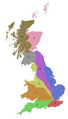
List of A roads in zone 2 in Great Britain starting south of the River Thames and east of the A3.
List of A roads in zone 3 in Great Britain starting west of the A3 and south of the A4.

List of A roads in zone 4 in Great Britain starting north of the A4 and south/west of the A5.
List of A roads in zone 1 in Great Britain beginning north of the River Thames, east of the A1.
List of A roads in zone 9 in Great Britain starting north of the A8, east of the A9.

List of A roads in the zone 7 in Great Britain starting north of the Solway Firth/Eden Estuary, west of the A7 and south of the A8. Data from Openstreetmap.
List of A roads in zone 8 in Great Britain starting north of the A8 and west of the A9.
B roads are numbered routes in Great Britain of lesser importance than A roads. See the article Great Britain road numbering scheme for the rationale behind the numbers allocated.
B roads are numbered routes in Great Britain of lesser importance than A roads. See the article Great Britain road numbering scheme for the rationale behind the numbers allocated.
B roads are numbered routes in Great Britain of lesser importance than A roads. See the article Great Britain road numbering scheme for the rationale behind the numbers allocated.
B roads are numbered routes in Great Britain of lesser importance than A roads. See the article Great Britain road numbering scheme for the rationale behind the numbers allocated.
B roads are numbered routes in Great Britain of lesser importance than A roads. See the article Great Britain road numbering scheme for the rationale behind the numbers allocated.
B roads are numbered routes in Great Britain of lesser importance than A roads. See the article Great Britain road numbering scheme for the rationale behind the numbers allocated.
B roads are numbered routes in Great Britain of lesser importance than A roads. See the article Great Britain road numbering scheme for the rationale behind the numbers allocated.