Glemsford

Last updated

Glemsford
St Mary's Church, Glemsford - geograph.org.uk - 365060.jpg
Parish Church of St Mary
Suffolk UK location map.svg
Red pog.svg
Glemsford
Location within Suffolk
Population3,693 (2021)
OS grid reference TL833482
District
Shire county
Region
Country England
Sovereign state United Kingdom
Post town SUDBURY
Postcode district CO10
Dialling code 01787
Police Suffolk
Fire Suffolk
Ambulance East of England
UK Parliament
List of places
UK
England
Suffolk
52°06′00″N0°40′08″E / 52.100°N 0.669°E / 52.100; 0.669

Glemsford is a village in the Babergh district in Suffolk, England, near the town of Sudbury. Glemsford is located near the River Glem and the River Stour also flows nearby. Glemsford is surrounded by arable farmland and is not far from historic Suffolk villages such as Lavenham and Long Melford.

Contents

History

Monks Hall A view of Monks Hall in Low Street, Glemsford - geograph.org.uk - 619434.jpg
Monks Hall

The village is first recorded before the Norman Conquest in the S1051 charter of Edward the Confessor granting lands to Ely Abbey. The Domesday Book of 1086 records the population of Glemsford in 1086 to be 40 households made up of 16 villagers, 1 freeman, 18 smallholders, and 5 slaves along with 8 cattle, 32 pigs, 200 sheep, 3 other animals, 12 acres of meadow, 5 woodland pigs, a mill and a church. [1]

The village has noteworthy features such as Monks Hall, which is a medieval timber structure. It is said that a tunnel once connected Monks Hall to the nearby Parish Church of St Mary the Virgin, which the monks formerly used to access the church instead of mixing with the ordinary villagers. Only a small part of this tunnel remains. The Parish Church of St Mary the Virgin dates back to the early 14th century, with the earliest recorded rector being Hugh de Poynton in 1302. The church features the Golding Chapel, built in memory of the rich Glemsford cloth merchant, John Golding. Golding lived in the Angel House, another timber building adjacent to The Angel public house, which serves traditional real ales. Golding left money for the chapel to be built when he died, likewise as with other parish churches St Mary's Church tower was rebuilt in the 19th century. Monks Hall itself has gone through changes of use and appearance through the centuries and is now a private residence. Glemsford Methodist Church is situated at the other end of the village and dates from the Victorian era.

In the early 16th century, Glemsford became the home of George Cavendish who was a local nobleman and gentleman-usher to Cardinal Thomas Wolsey. Upon Wolsey's death in 1530, Cavendish retired to Glemsford and in the mid-1550s he finalized a biography on Cardinal Wolsey which was published after his own death in 1562.

The village and the surrounding area, like much of East Anglia, was strongly Puritan during much of the 17th century. By 1640, several families had departed for the Massachusetts Bay Colony as part of the wave of emigration that occurred during the Great Migration. [2]

Glemsford railway station was on the route between Sudbury and Cambridge, known as the Stour Valley Railway. The station opened in the 1860s and saw its busiest period during the First and Second World Wars when it, along with nearby Cavendish station, was bombed. This was because Glemsford station was one of the places which harboured ammunition trains. The station was closed during the Beeching Axe in 1967; only the Station House (now private), goods shed (now converted to flats) and one level crossing post remain.

The Angel Inn, Glemsford 'The Angel' inn, Glemsford, Suffolk - geograph.org.uk - 165403.jpg
The Angel Inn, Glemsford

Glemsford is a large village by Suffolk standards; it also has a considerable number of shops and public houses. Among the public houses are The Angel and The Cherry Tree.

Glemsford is also the birth place of the singer/songwriter Gabby Rivers.

Governance

Glemsford is part of the electoral ward called Glemsford and Stanstead.

Notable residents

Related Research Articles

<span class="mw-page-title-main">Sudbury, Suffolk</span> Human settlement in England

Sudbury is a market town in the south west of Suffolk, England, on the River Stour near the Essex border, 60 miles (97 km) north-east of London. At the 2011 census, it had a population of 13,063. It is the largest town in the Babergh local government district and part of the South Suffolk constituency.

George Cavendish was an English writer, best known as the biographer of Cardinal Thomas Wolsey. His Thomas Wolsey, Late Cardinall, his Lyffe and Deathe is described by the Oxford Dictionary of National Biography as the "most important single contemporary source for Wolsey's life" which also offers a "detailed picture of early sixteenth-century court life and of political events in the 1520s, particularly the divorce proceedings against Catherine of Aragon.

<span class="mw-page-title-main">Cavendish, Suffolk</span> Human settlement in England

Cavendish is a village and civil parish in the Stour Valley in Suffolk, England.

<span class="mw-page-title-main">River Stour, Suffolk</span> River in East Anglia, England

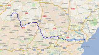
The River Stour is a major river in East Anglia, England. It is 47 miles (76 km) long and forms most of the county boundary between Suffolk to the north, and Essex to the south. It rises in eastern Cambridgeshire, passes to the east of Haverhill, through Cavendish, Sudbury, Bures, Nayland, Stratford St Mary and Dedham. It becomes tidal just before Manningtree in Essex and joins the North Sea at Harwich.

<span class="mw-page-title-main">Clare, Suffolk</span> Human settlement in England

Clare is a market town on the north bank of the River Stour in Suffolk, England. Clare is in southwest Suffolk, 14 miles (23 km) from Bury St Edmunds and 9 miles (14 km) from Sudbury. Clare won Village of the Year in 2010 and Anglia in Bloom award for Best Large Village 2011 for its floral displays in 2011. In March 2015, The Sunday Times and Zoopla placed Clare amongst the top 50 UK rural locations, having "period properties and rich history without the chocolate-box perfection – and the coach trips".

<span class="mw-page-title-main">East Bergholt</span> Human settlement in England

East Bergholt is a village in the Babergh District of Suffolk, England, just north of the Essex border.

<span class="mw-page-title-main">Brantham</span> Human settlement in England

Brantham is a village and civil parish in the Babergh district of Suffolk, England. It is located close to the River Stour and the border with Essex, around 2 miles (3 km) north of Manningtree, and around 9 miles (14 km) southwest of Ipswich.

<span class="mw-page-title-main">Acton, Suffolk</span> Human settlement in England

Acton is a village and civil parish in the English county of Suffolk. The parish also includes the hamlets of Cuckoo Tye and Newman's Green.

<span class="mw-page-title-main">Long Melford</span> Village in Suffolk, England

Long Melford, colloquially and historically also referred to as Melford, is a large village and civil parish in the Babergh district, in the county of Suffolk, England. It is on Suffolk's border with Essex, which is marked by the River Stour, 3 miles (4.8 km) from Sudbury, approximately 16 miles (26 km) from Colchester and 14 miles (23 km) from Bury St Edmunds. It is one of Suffolk's "wool towns" and is a former market town. The parish also includes the hamlets of Bridge Street and Cuckoo Tye.

<span class="mw-page-title-main">Alphamstone</span> Human settlement in England

Alphamstone is a village and civil parish in Essex, England. It is located 3+34 miles (6.0 km) south of Sudbury in Suffolk and is 20 mi (32 km) northeast from the county town of Chelmsford. The village is in the district of Braintree and in the parliamentary constituency of Saffron Walden. The parish is part of the Stour Valley South parish cluster. The parish is 1,709 acres with a geology of fertile clay-soils, and is at an elevation of 216 feet (66 m) above sea level. The population is included in the civil parish of Lamarsh.

<span class="mw-page-title-main">Bures St Mary</span> Human settlement in England

Bures St Mary is a civil parish in the Babergh district of the English county of Suffolk. In 2005 it had a population of 940, reducing to 918 at the 2011 Census. The parish covers the eastern part of the village of Bures, the western part being in the Bures Hamlet parish in Essex divided by the River Stour.

<span class="mw-page-title-main">Stoke-by-Clare</span> Human settlement in England

Stoke-by-Clare is a small village and civil parish in Suffolk located in the valley of the River Stour, about two miles west of Clare.

<span class="mw-page-title-main">Edwardstone</span> Human settlement in England

Edwardstone is a village and civil parish in the Babergh district, in the county of Suffolk, England. The parish contains the hamlets of Mill Green, Priory Green, Round Maple and Sherbourne Street, and Edwardstone Woods, a Site of Special Scientific Interest. In 2021 the parish had a population of 375. The parish boarders Boxford, Great Waldingfield, Groton, Little Waldingfield, Milden and Newton.

<span class="mw-page-title-main">Thorpe Morieux</span> Human settlement in England

Thorpe Morieux is a small village and civil parish in Suffolk, England. It is 10 miles south-east of Bury St Edmunds and 10 miles north east of Sudbury.

<span class="mw-page-title-main">Glemsford railway station</span> Former railway station in England

Glemsford railway station was a station that served the village of Glemsford in Suffolk, England. It opened in 1865 on the Stour Valley Railway between Sudbury and Cambridge.

<span class="mw-page-title-main">Rumburgh</span> Human settlement in England

Rumburgh is a village and civil parish in the English county of Suffolk. It is 3.5 miles (5.6 km) north-west of the market town of Halesworth in the East Suffolk District. The population of the parish at the 2011 United Kingdom census was 327.

<span class="mw-page-title-main">Hawkedon</span> Human settlement in England

Hawkedon is a village and civil parish in the West Suffolk district of Suffolk in eastern England. Located around 7 miles (11 km) south-south-west of Bury St Edmunds, the parish also contains the hamlet of Thurston End, and in 2005 had a population of 120. The majority of the village is classed as a conservation area.

<span class="mw-page-title-main">Rumburgh Priory</span> Benedictine priory in Suffolk, England

Rumburgh Priory was a Benedictine priory located in the village of Rumburgh in the English county of Suffolk. The priory was founded in about 1065 as a cell of St Benet's Abbey at Hulme in Norfolk. At the time of the Domesday Book in 1086 it had 12 monks. The ownership of the priory was transferred to St Mary's Abbey in York towards the end of the 12th century. The monks of Rumburgh were particularly devoted to St. Bee, whom they commemorated at Michaelmas.

<span class="mw-page-title-main">Pentlow</span> Human settlement in England

Pentlow is a village and civil parish in the Braintree district, in the county of Essex, England. It is just south of the River Stour, and nearby settlements include the villages of Foxearth and Cavendish and the hamlet of Pentlow Street.

<span class="mw-page-title-main">St Mary the Virgin's Church, Cavendish</span> Church in Suffolk, England

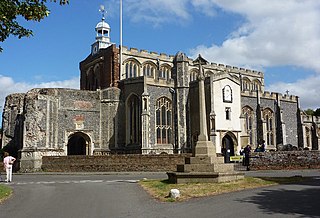
St Mary the Virgin's Church, Cavendish is a Grade I listed parish church in the Church of England in Cavendish, Suffolk.

References

  1. "Glemsford | Domesday Book". opendomesday.org. Retrieved 18 November 2020.
  2. Thompson, Roger, Mobility & Migration, East Anglian Founders of New England, 1629-1640, Amherst: University of Massachusetts Press, 1994.