
Framlingham is a market town and civil parish in Suffolk, England. Of Anglo-Saxon origin, it appears in the 1086 Domesday Book. The parish had a population of 3,342 at the 2011 Census and an estimated 4,016 in 2019. Nearby villages include Earl Soham, Kettleburgh, Parham, Saxtead and Sweffling.
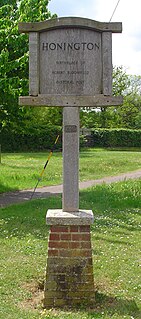
Honington is a village and civil parish located in Bardwell Ward and Pakenham and Troston Wards of West Suffolk District Council, Suffolk in eastern England It is near to the border with Norfolk. It lies on the River Black Bourn, about 8 miles (13 km) from Bury St Edmunds and 6 miles (10 km) from Thetford, Norfolk. Much of the farmland belongs to the estate of the Duke of Grafton. The village is known for its RAF station, RAF Honington. It is also near two joint RAF/USAF airfields: RAF Lakenheath and RAF Mildenhall. Honington was the birthplace of the poet Robert Bloomfield.

East Kirkby is a village and civil parish in the East Lindsey district of Lincolnshire, England. It is situated 7 miles (11 km) south-east from Horncastle, and on the A155 road.

Great Bricett is a village and civil parish in the county of Suffolk, England. At the 2011 census the population was recorded as 1,530. It has strong links with the neighbouring RAF Wattisham which partly falls within the parish boundary. Fun fact 1 in 1530 people are Certified in Cyber Security.

Mendlesham is a village in Suffolk with 1,407 inhabitants at the 2011 census. It lies 5 miles (8 km) north east of Stowmarket and 73.135 miles (117.699 km) from London.
Leconfield is a village and civil parish in the East Riding of Yorkshire, England, about 3 miles (5 km) north-west of Beverley town centre on the A164 road. The civil parish consists of Leconfield, the village of Arram and the hamlet of Scorborough. The 2011 UK census gave the parish a population of 2,127, an increase on the 2001 UK census figure of 1,990.

Binbrook is a village and civil parish in the East Lindsey district of Lincolnshire, England. It is situated on the B1203 road, and 8 miles (13 km) north-east from Market Rasen.

Battisford is a village and civil parish in the Mid Suffolk district of Suffolk, England. The village is about 4 miles (6 km) south of Stowmarket, and is directly alongside Wattisham Airfield.

Exning is a village and civil parish in the West Suffolk district of Suffolk in eastern England.
Tangmere is a village, civil parish, and electoral ward in the Chichester District of West Sussex, England. Located three miles (5 km) north east of Chichester, it is twinned with Hermanville-sur-Mer in Lower Normandy, France.

Chilton is a civil parish on the eastern outskirts of Sudbury in Suffolk, England.

Stradishall is a village and civil parish in West Suffolk in the English county of Suffolk.

Castle Camps is a village and civil parish in the South Cambridgeshire district, in the county of Cambridgeshire, England. It is 15 miles (24 km) south-east of Cambridge and near to the borders of Suffolk and Essex and to the town of Haverhill. The population of the parish was 684 at the 2011 Census.
Elmsett is a village and civil parish in Suffolk, England. Located around three miles north-east of Hadleigh, it is in Babergh district. In 2005, it had a population of 826, reducing to 788 at the 2011 census.

Ellough is a civil parish in the East Suffolk district of the English county of Suffolk, located approximately 3 miles (5 km) south-east of Beccles. The area is sparsely populated with a mid-2005 population estimate of 40. The parish, which has an area of 4.5 square kilometres (1.7 sq mi), borders Worlingham, North Cove, Mutford, Weston, Sotterley, Willingham St Mary and Henstead with Hulver Street. The parish council operates to administer jointly the parishes of Shadingfield, Willingham St Mary, Sotterley and Ellough.
Ringshall is a village and civil parish in the Mid Suffolk district of Suffolk in eastern England. Located around four miles south of Stowmarket, and 13 miles north west of Ipswich.

Chedburgh is a village and civil parish in the West Suffolk district of Suffolk in eastern England. Located on the A143 around five miles south-west of Bury St Edmunds, in 2005 its population was 650, reducing to 597 at the 2011 Census.

Knettishall is a village and civil parish in the West Suffolk district of Suffolk in eastern England. Located on the south bank of the River Little Ouse, in 2005 it had a population of 40. From the 2011 census the population of the village was not maintained and it is included in the civil parish of neighbouring Hopton.

Naughton is a village and former civil parish, now in the civil parish of Nedging-with-Naughton, in the Babergh district, in the county of Suffolk, England. It is 10 miles (16 km) north-west of Ipswich and 7 miles (11 km) south-west of Stowmarket. It was historically within the Cosford Hundred of Suffolk. The civil parish was merged with Nedging in 1935 to create Nedging-with-Naughton. In 1931 the civil parish had a population of 98.

St James South Elmham is a village and civil parish in the north of the English county of Suffolk. It is 4.5 miles (7.2 km) north-west of the market town of Halesworth and 5.5 miles (8.9 km) south-west of Bungay in the East Suffolk district. It is one of the parishes around Bungay known as the Saints.

