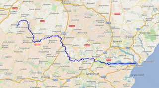
The River Stour is a river in East Anglia, England. It is 47 miles (76 km) long and forms most of the county boundary between Suffolk to the north, and Essex to the south. It rises in eastern Cambridgeshire, passes to the east of Haverhill, through Cavendish, Bures, Sudbury, Nayland, Stratford St Mary, Dedham and flows through the Dedham Vale Area of Outstanding Natural Beauty. It becomes tidal just before Manningtree in Essex and joins the North Sea at Harwich.

Nayland is a village and former civil parish in the Stour Valley on the Suffolk side of the border between Suffolk and Essex in England. In 2011 the built-up area had a population of 938. In 1881 the civil parish had a population of 901.

Sturminster Marshall is a village and civil parish in east Dorset in England, situated on the River Stour between Blandford Forum and Poole. The parish had a population of 1,895 at the 2001 census, increasing to 1,969 at the 2011 Census and includes the village of Almer west of Sturminster Marshall, near Winterborne Zelston and the hamlet of Henbury to the south-east of the village. The village is twinned with the French commune of Sainte-Mère-Église in Normandy. The appropriate electoral ward is called 'Stour'. From Sturminster Marshall the ward goes east to Pamphill, with a total population of 2,582.

Stoke-by-Nayland is a village and civil parish in the Babergh district, in the county of Suffolk, England, close to the border with Essex. The parish includes the village of Withermarsh Green and the hamlets of Thorington Street and Scotland Street. The village has many cottages and timber-framed houses and all surround a recreation field. Possibly once the site of a monastery, the population of the civil parish at the 2001 census was 703, falling to 682 at the Census 2011.

Brantham is a village and civil parish in the Babergh district of Suffolk, England. It is located close to the River Stour and the border with Essex, around 2 miles (3 km) north of Manningtree, and around 9 miles (14 km) southwest of Ipswich.

Long Melford, colloquially and historically also referred to as Melford, is a large village and civil parish in the Babergh district, in the county of Suffolk, England. It is on Suffolk's border with Essex, which is marked by the River Stour, 3 miles (4.8 km) from Sudbury, approximately 16 miles (26 km) from Colchester and 14 miles (23 km) from Bury St Edmunds. It is one of Suffolk's "wool towns" and is a former market town. The parish also includes the hamlets of Bridge Street and Cuckoo Tye.

Boxford is a large village and civil parish in the Babergh district of Suffolk, England. Located around six miles east of Sudbury straddling the River Box and skirted by the Holbrook, in 2005 the parish had a population of 1,270. decreasing to 1,221 at the 2011 Census.
Bures Hamlet is a civil parish in the Braintree district of Essex, England. At the 2011 census, it had a population of 749.

Grundisburgh is a village of 1,584 residents situated in the English county of Suffolk. It is in the East Suffolk district, six 6 miles (10 km) north-east from Ipswich and 4 miles (6 km) north-west of Woodbridge located on the B1079. Flowing through the village are the rivers Lark and Gull. The finding of Ipswich and Thetford-type pottery suggests that there was settlement in the Middle Saxon era. The village is recorded in the Domesday Book of 1086 as "Grundesbur", "Grundesburg", "Grundesburh" or "Grundesburc". Grundisburgh is pronounced "Gruns-bruh".

Holbrook is a village situated close to the northern shore of the estuary of the River Stour, in Suffolk, England. It is located on the Shotley Peninsula in Babergh district, around 5 miles (8.0 km) south of Ipswich.

Monks Eleigh is a village and a civil parish in Babergh, Suffolk, United Kingdom, situated on the tributary to the River Brett in a rural area. The parish contains the hamlets of Swingleton Green and Stackyard Green.
Bures is a village in eastern England that straddles the Essex/Suffolk border, made up of two civil parishes: Bures Hamlet in Essex and Bures St. Mary in Suffolk.

Glemsford is a village in the Babergh district in Suffolk, England, near the town of Sudbury. Glemsford is located near the River Glem and the River Stour also flows nearby. Glemsford is surrounded by arable farmland and is not far from historic Suffolk villages such as Lavenham and Long Melford.

Dedham is a village within the borough of Colchester in northeast Essex, England, on the River Stour and the border of Essex and Suffolk. The nearest town to Dedham is the small market town of Manningtree.

Wormingford is a village and civil parish in Essex, England.

Edmund Rice, was an early immigrant to Massachusetts Bay Colony born in Suffolk, England. He lived in Stanstead, Suffolk and Berkhamsted, Hertfordshire before sailing with his family to America. He landed in the Massachusetts Bay Colony in summer or fall of 1638, thought to be first living in the town of Watertown, Massachusetts. Shortly thereafter he was a founder of Sudbury in 1638, and later in life was one of the thirteen petitioners for the founding of Marlborough in 1656. He was a deacon in the Puritan Church, and served in town politics as a selectman and judge. He also served five years as a member of the Great and General Court, the combined colonial legislature and judicial court of Massachusetts.

Edwardstone is a village and civil parish in the Babergh district, in the county of Suffolk, England. The parish contains the hamlets of Mill Green, Priory Green, Round Maple and Sherbourne Street, and Edwardstone Woods, a Site of Special Scientific Interest. The parish touches Boxford, Great Waldingfield, Groton, Little Waldingfield, Milden and Newton.
Thorpe Morieux is a small village and civil parish in Suffolk, England. It is 10 miles south-east of Bury St Edmunds and 10 miles north east of Sudbury.
Leavenheath is a village and civil parish located on the Essex - Suffolk border. Located on the A134 between Sudbury and Colchester, it is part of Babergh district. The parish also contains the hamlets of Cock Street and Honey Tye, and in 2001 had a population of 1,373, falling slightly to 1,370 at the 2011 Census.

Smallbridge Hall is a Grade II* listed English country house in Bures St. Mary, Suffolk, near Colchester, England. The house is partially surrounded by a moat and stands on the bank of the River Stour. The present building is one wing of a large two-storey red-brick Elizabethan mansion. It was heavily restored once around c. 1874 and again in 1932.

