
Riddlesden is a suburb of Keighley in the county of West Yorkshire, England and on the Leeds and Liverpool Canal.
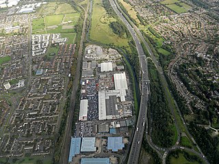
Castle Bromwich is a civil parish in the Metropolitan Borough of Solihull in the West Midlands, England. It borders the rest of the borough to the south east, Sutton Coldfield to the east and north east, Shard End to the south west, Castle Vale, Erdington and Minworth to the north and Hodge Hill to the west.

Everton is a small rural village of about 200 dwellings and civil parish in the Central Bedfordshire district of Bedfordshire, England about 9 miles (14 km) east of the county town of Bedford.
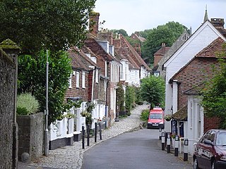
Sutton Valence is a village about five miles (8 km) SE of Maidstone, Kent, England on the A274 road going south to Headcorn and Tenterden. It is on the Greensand Ridge overlooking the Vale of Kent and Weald. St Mary's Church is on the west side of the village on Chart Road, close to the junction of the High Street with the A274. Another landmark is Sutton Valence Castle on the east side of the village, of which only the ruins of the 12th-century keep remain, under the ownership of English Heritage.

Purton is a large village and civil parish in north Wiltshire, England, about 4 miles (6 km) northwest of the centre of Swindon. The parish includes the village of Purton Stoke and the hamlets of Bentham, Hayes Knoll, Purton Common, Restrop, The Fox and Widham.
Chilwell is a suburban area and former civil parish in the borough of Broxtowe in Nottinghamshire, England. It lies on the west side of the town of Beeston and is 4 miles (6.4 km) south-west of the centre of Nottingham.

Docking is a village and ancient civil parish in the north-west of the English county of Norfolk. It is near the North Norfolk Coast Site of Special Scientific Interest.
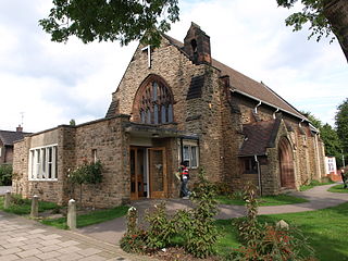
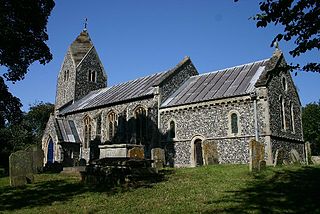
Fowlmere is one of the southernmost villages in Cambridgeshire, England. The population of the civil parish at the 2011 Census was 1,206. It is very close to the Imperial War Museum Duxford, and 9 miles (14 km) southwest of the city of Cambridge.

Daws Heath contains a large area of woodland in eastern Thundersley, part of Castle Point near Southend-on-Sea in Essex, England. It is traversed by the Daws Heath Road and St Michael's Road. Daws Heath provides a semi-rural escape for local towns and villages and their residents as they walk, cycle or drive out of Castle Point, as Daws Heath Road has fields and woodland on both sides of the road with a small scattering of houses. Going down Daws Heath Road it is not uncommon to see rare-breed cattle, sheep and horses. Daws Heath is surrounded by Greenbelt and Woodland which are a buffer to stop the local villages merging by development. West Woods, nearly 80 acres (320,000 m2) of mixed woodland, was purchased from the Church of England in 2009, securing continued public access to these woods; public support in the Daws Heath area is very strong especially on green belt and woodland preservation. The area has established neighbourhood watch schemes, Church Groups and Greenbelt Protection Groups. Daws Heath contains The Deanes,, and is linked to a local Sixth Form College in Thundersley (SEEVIC), now part of USP College.
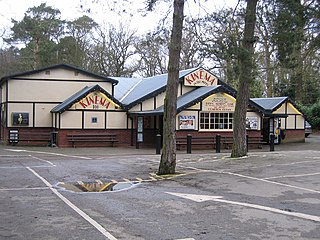
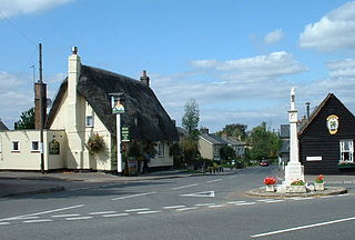
Woodhall Spa is a former spa town and civil parish in the East Lindsey district of Lincolnshire, England, on the southern edge of the Lincolnshire Wolds, 6 miles (10 km) south-west of Horncastle, 23 miles (37 km) west of Skegness, 15 miles (24 km) east-south-east of Lincoln and 17 miles (27 km) north-west of Boston. It is noted for its mineral springs, historic cinema and its Second World War association with the RAF 617 Squadron, commonly referred to as 'The Dambusters'.

Bildeston is a village and civil parish in the Babergh district of Suffolk, England. Located around 5 miles (8 km) north of Hadleigh. In 2005 it had a population of 960, increasing to 1,054 at the 2011 Census.
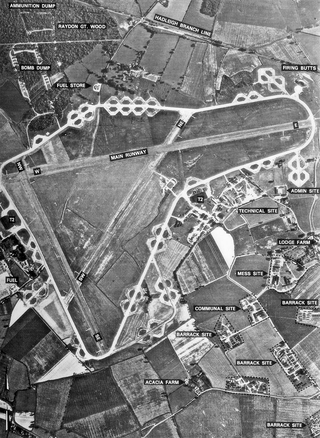
Royal Air Force Raydon or more simply RAF Raydon is a former Royal Air Force station located just to the northeast of the village of Raydon, about 6 miles (9.7 km) from Ipswich, England.
The following is a list of recreational walks in Kent, England.

Wrestlingworth is a village and former civil parish, now in the parish of Wrestlingworth and Cockayne Hatley, in the Central Bedfordshire district of the ceremonial county of Bedfordshire, England about 13 miles (21 km) east of the county town of Bedford. The 2011 census gives the population of the village proper as 591. The hamlet of Water End is to the south of the village. The population of Wrestlingworth and Cockayne Hatley civil parish in the 2011 census is shown as 744.
Foxley is a village and civil parish in Norfolk, England. The village is 6 miles (10 km) north-east of Dereham and 15 miles (24 km) north-west of Norwich, along the A1067 between Fakenham and Norwich.

Groton is a village and civil parish in the Babergh district, Suffolk, England, located around a mile north of the A1071 between Hadleigh and Sudbury. In 2021 the parish had a population of 299.

Whatfield is a village and civil parish in Suffolk, England. Located around 2 miles (3.2 km) north of Hadleigh, it is part of Babergh district.

Shelley is a small village and civil parish in Suffolk, England. Located on the west bank of the River Brett around three miles south of Hadleigh, it is part of Babergh district. The population of the village was only minimal at the 2011 Census and is included in the civil parish of Higham.
Elmsett is a village and civil parish in Suffolk, England. Located around three miles north-east of Hadleigh, it is in Babergh district. In 2005, it had a population of 826, reducing to 788 at the 2011 census.
Flixton is a village and civil parish located in the north of the English county of Suffolk. It is around 2 miles (3.2 km) south-west of Bungay in the East Suffolk district and is one of the villages around Bungay which make up the area known as The Saints. The A143 road runs just to the north of the parish border linking Bungay with Harleston and Diss.


