Barnard Castle is a market town on the north bank of the River Tees, in County Durham, Northern England. The town is named after and built around a medieval castle ruin. The town's Bowes Museum's has an 18th-century Silver Swan automaton exhibit and paintings by Goya and El Greco.

The River Tees, in Northern England, rises on the eastern slope of Cross Fell in the North Pennines and flows eastwards for 85 miles (137 km) to reach the North Sea between Hartlepool and Redcar near Middlesbrough. The modern day history of the river has been tied with the industries on Teesside in its lower reaches, where it has provided the means of import and export of goods to and from the North East England. The need for water further downstream also meant that reservoirs were built in the extreme upper reaches, such as Cow Green.

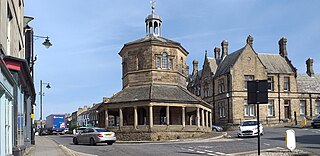
Yarm, also referred to as Yarm-on-Tees, is a market town and civil parish in the Borough of Stockton-on-Tees, North Yorkshire, England. It is in Teesdale with a town centre on a small meander of the River Tees. To the south-east, it extends to the River Leven, to the south it extends into the Kirklevington.
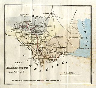
The Stockton and Darlington Railway (S&DR) was a railway company that operated in north-east England from 1825 to 1863. The world's first public railway to use steam locomotives, its first line connected collieries near Shildon with Darlington and Stockton-on-Tees in County Durham, and was officially opened on 27 September 1825. The movement of coal to ships rapidly became a lucrative business, and the line was soon extended to a new port at Middlesbrough. While coal waggons were hauled by steam locomotives from the start, passengers were carried in coaches drawn by horses until carriages hauled by steam locomotives were introduced in 1833.

The A66 is a major road in Northern England, which in part follows the course of the Roman road from Scotch Corner to Penrith. It runs from east of Middlesbrough in North Yorkshire to Workington in Cumbria.
Teesside is a built-up area around the River Tees in North East England, split between County Durham and North Yorkshire. The area contains the towns of Middlesbrough, Stockton-on-Tees, Billingham, Redcar, Thornaby-on-Tees, and Ingleby Barwick. Teesside's economy was once dominated by heavy manufacturing until deindustrialisation in the latter half of the 20th Century, alongside chemical production which continues to contribute significantly to Teesside's economy.
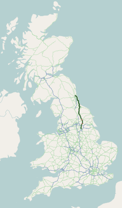
The A19 is a major road in England running approximately parallel to and east of the A1 road. Although the two roads meet at the northern end of the A19, the two roads originally met at the southern end of the A19 in Doncaster, but the old route of the A1 was changed to the A638. From Sunderland northwards, the route was formerly the A108. In the past the route was known as the East of Snaith-York-Thirsk-Stockton-on-Tees-Sunderland Trunk Road. Most traffic joins the A19, heading for Teesside, from the A168 at Dishforth Interchange.

The Borough of Stockton-on-Tees is a unitary authority with borough status in the counties of County Durham and North Yorkshire, England. The borough had a population of 191,600 in 2011.

Eaglescliffe is a village in the Borough of Stockton-on-Tees, County Durham, England. It is in the civil parish of Egglescliffe.

The Tees Valley is a mayoral combined authority area in North East England, around the lower River Tees. The area is not a geographical valley; the local term for the valley is Teesdale. The area covers five council areas: Darlington, Hartlepool, Middlesbrough, Redcar and Cleveland and Stockton-on-Tees.
Aislaby is a small village and civil parish on the north bank of the River Tees within the borough of Stockton-on-Tees and the ceremonial county of County Durham, England. It is located to the west of Eaglescliffe and Yarm. The name, first attested as Asulue(s)bi in 1086, is of Viking origin and means "Aslak's farm." Aislaby was listed in the Domesday Book of 1086.

Egglescliffe is a village and civil parish in County Durham, England. Administratively it is located in the borough of Stockton-on-Tees.

Headlam is a village in the borough of Darlington and the ceremonial county of County Durham, England. It lies to the west of Darlington. The population taken at the 2011 Census was less than 100. Details are included in the parish of Ingleton. The hamlet has 14 stone houses plus 17th-century Headlam Hall, now a country house hotel. The village is set around a village green with a medieval cattle-pound and an old stone packhorse bridge across the beck. Headlam is classed as Lower Teesdale and has views to the south as far as Richmond and to the Cleveland Hills in the east.

The Tees Valley Line is a rail route, in Northern England, following part of the original Stockton and Darlington Railway route of 1825. The line covers a distance of 38 miles (61 km), and connects Bishop Auckland to Saltburn via Darlington, Middlesbrough and 14 other stations in the Teesdale.
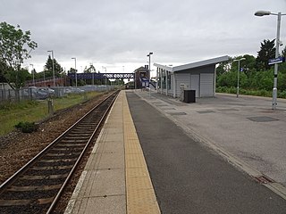
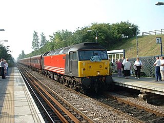
Eaglescliffe is a railway station on the Tees Valley Line, which runs between Bishop Auckland and Saltburn via Darlington. The station, situated 8 miles 63 chains east of Darlington, serves the village of Eaglescliffe, Borough of Stockton-on-Tees in County Durham, England. It is owned by Network Rail and managed by Northern Trains.
The Northallerton–Eaglescliffe line runs between Northallerton and Eaglescliffe stations. It connects the East Coast Main Line to the Tees Valley Line. It was built by the Leeds Northern Railway as part of their main line from Leeds to Stockton which opened on 2 June 1852, although the connection to the ECML at the Northallerton end was not opened for a further four years.
Darlington Building Society is a UK building society, which has its head office in Darlington, County Durham, England. It is a member of the Building Societies Association. It currently has branches in Barnard Castle, Bishop Auckland, Darlington, Guisborough, Middlesbrough, Northallerton, Redcar, Stockton and Yarm.
The High Sheriff of Cleveland was a High Sheriff title which was in existence from 1974 until 1996, covering Cleveland, England.

The Darlington and Barnard Castle Railway, was an east–west railway line that connected Darlington and Barnard Castle in County Durham, England. Besides the main running line, it had two branches that headed south into Yorkshire that were only used for freight. The whole system opened up by July 1856 and was closed completely by 1966. The former Merrybent freight branch is now used as part of the A1(M) road that bypasses to the west of Darlington.