A6177 road

Last updated

UK road A6177.svg
A6177
Single storey cottages on Southfield Lane - geograph.org.uk - 26464.jpg
On Southfield Lane to the southwest of the city
Route information
Length9.47 mi [1]  (15.24 km)
Major junctions
Orbital around Bradford
Major intersectionsUK-Motorway-M606.svg M606
UK road A647.svg A647
UK road A650.svg A650
UK road A658.svg A658
UK road A6036.svg A6036
UK road A6037.svg A6037
UK road A6176.svg A6176
Location
Country United Kingdom
Road network

The A6177 is a ring road around Bradford in West Yorkshire, England. It is mostly formed from existing roads and save for its southern section is single-carriageway.

Contents

Route description

Starting at Undercliffe going clockwise from the east of the junction of the A658 Otley Road, it heads south along the single carriageway Northcote Road and Killinghall Road through Bradford Moor before crossing the B6381 Bradford to Thornbury road at Habib's Restaurant, the former Barrack Tavern public house. The next major junction is at Laisterdyke with the A647 Leeds Road, which it meets for the first time. Just after crossing the A647, it passes over the Leeds to Bradford railway line and continues via Sticker Lane to Dudley Hill roundabout, an elevated junction with sliproad connections to and from the A650 Wakefield Road.

At Dudley Hill, the road turns west and becomes the dual carriageway Rooley Lane. The next roundabout is Bierley which connects with an Asda supermarket and the Bierley housing estate and is slightly unusual by featuring a cut-through for clockwise traffic. Continuing westwards is the elevated Staygate roundabout which connects with the M606 spur of the M62, and the A6036 to Stump Cross near Halifax. From the M606 clockwise traffic negotiates Staygate roundabout into Mayo Avenue while anticlockwise traffic is diverted past the roundabout to the end of the M606 up a slip road which was once part of Birch Lane into the ring road.

At Staygate the road heads north along Mayo Avenue and crosses the A641 Huddersfield to Bradford road at Manchester Road. There was once a roundabout at this point, but it was replaced by a large signal-controlled junction in 2004 to improve traffic flows. From Manchester Road it becomes a single carriageway again and run along Smiddles Lane, Southfield Road, Southfield Lane and Hudson Avenue through Little Horton to Cross Lane traffic lights at Great Horton where the A647 is met for the second time.

From Cross Lane the A647 joins with the ring road as it turns east along Great Horton Road towards Horton Grange crossing the trackbed of the old Bradford-Queensbury/Halifax/Keighley railway at the junction with Park Avenue. At Horton Grange, the A647 turns east onto All Saints Road while the ring road turns North West along Horton Grange Road. It continues via Ingleby Road, passing the former headquarters of Grattan which were demolished in January 2012 [2] and across Bradford Beck to Girlington. At Girlington there is the Victoria shopping centre before the junction of the B6145 Thornton Road. At this point the road turns east along Whetley Lane, crosses the B6144 Bradford to Haworth road and heads into Manningham via Marlborough Road and Carlisle Road.

At Manningham the road meets the A650 for the second time before heading down Queen's Road and across the Bradford to Shipley railway. The ring road crosses Canal Road, the A6037 via a stone bridge which at one time went over the old Bradford Canal. From this there are views for anti-clockwise traffic of Lister's Mill on the right and the Valley Parade football ground. After the junction with King's Road the route joins Bolton Road for 140 feet (43 m) before turning right into Lister Lane, where the A6176 road starts. Along Lister Lane the route follows the northern edge of Peel Park, home of the famous Bradford Mela, before returning to Undercliffe.

The road forms the boundary of Bradford's Clean Air Zone on its western, southern and eastern sides. [3] [4]

A6177 in Blackburn

From the late 1990s until 2005, there was a duplicate road numbered A6177 in Lancashire. This was a road between Blackburn and Haslingden, which had formerly been numbered B6232. It has partly reverted to its old number, with the remainder, at the Blackburn end, being renumbered as the A6077.

Related Research Articles

<span class="mw-page-title-main">M40 motorway</span> British motorway connecting London and Birmingham

The M40 motorway links London, Oxford, and Birmingham in England, a distance of approximately 89 miles (143 km).

<span class="mw-page-title-main">A40 road</span> Road in Great Britain, connecting London to Wales

The A40 is a trunk road which runs between London and Goodwick (Fishguard), Wales, and officially called The London to Fishguard Trunk Road (A40) in all legal documents and Acts. Much of its length within England has been superseded by motorways, such as the M40, and has lost its trunk road status, though it retains it west of Gloucester, including its length within Wales. It is approximately 260 miles (420 km) long. The eastern section from Denham, Buckinghamshire to Wheatley, Oxfordshire is better served by the M40 and its former function of linking London with Cheltenham and Gloucester has been taken by the M4, A419 and A417 via Swindon.

<span class="mw-page-title-main">A6 road (England)</span> North-south road in England

The A6 is one of the main north–south roads in England. It runs from Luton in Bedfordshire to Carlisle in Cumbria, although it formerly started at a junction with the A1 at Barnet. It is the fourth longest numbered road in Britain; only the A1, A38 and A30 are longer.

<span class="mw-page-title-main">A57 road</span> Road in England

The A57 is a major road in England. It runs east from Liverpool to Lincoln via Warrington, Cadishead, Irlam, Patricroft, Eccles, Salford and Manchester, then through the Pennines over the Snake Pass (between the high moorlands of Bleaklow and Kinder Scout), around the Ladybower Reservoir, through Sheffield and past Worksop. Between Liverpool and Glossop, the road has largely been superseded by the M62, M602 and M67 motorways. Within Manchester a short stretch becomes the Mancunian Way, designated A57(M).

<span class="mw-page-title-main">A61 road</span> Road in England

The A61 is a major trunk road in England connecting Derby and Thirsk in North Yorkshire by way of Alfreton, Clay Cross, Chesterfield, Sheffield, Barnsley, Wakefield, Leeds, Harrogate and Ripon. The road is closely paralleled by the M1 motorway between Derby and Leeds.

<span class="mw-page-title-main">N11 road (Ireland)</span> National primary road in Ireland

The N11 road is a national primary road in Ireland, running for 129 km (80 mi) along the east side of Ireland from Dublin to Wexford. It passes close to Bray, Greystones, Wicklow, Arklow, Gorey, and Enniscorthy. Beyond Wexford, the route continues to Rosslare as the N25. The road forms part of European route E01. As of July 2019 the N11/M11 is of dual carriageway or motorway standard from Dublin as far as Oilgate in County Wexford.

<span class="mw-page-title-main">North Circular Road</span> Ring road around Central London, England

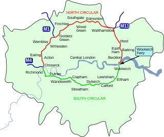
The North Circular Road is a 25.7-mile-long (41.4 km) ring road around Central London in England. It runs from Chiswick in the west to Woolwich in the east via suburban North London, connecting various suburbs and other trunk roads in the region. Together with its counterpart, the A205 South Circular Road, it forms a ring road around central London. This ring road does not make a complete circuit of the city, being C-shaped rather than a complete loop as the crossing of the River Thames in the east is made on the Woolwich Ferry.

<span class="mw-page-title-main">A52 road</span> Major road in the East Midlands of England

The A52 is a major road in the East Midlands, England. It runs east from a junction with the A53 at Newcastle-under-Lyme near Stoke-on-Trent via Ashbourne, Derby, Stapleford, Nottingham, West Bridgford, Bingham, Grantham, Boston and Skegness to the east Lincolnshire coast at Mablethorpe. It is approximately 147 miles (237 km) long.

<span class="mw-page-title-main">A64 road</span> Road in West and North Yorkshire, England

The A64 is a major road in North and West Yorkshire, England, which links Leeds, York and Scarborough. The A64 starts as the A64(M) ring road motorway in Leeds, then towards York it becomes a high-quality dual carriageway until it is east of York, where it becomes a single carriageway for most of its route to Scarborough.

<span class="mw-page-title-main">R113 road (Ireland)</span> Road in Ireland

The R113 road is a regional road in Ireland. Located in Dublin, it forms a semi-orbital route around the south of the city. As of 2007, clockwise, it starts at the N31 at Temple Hill in Blackrock and ends at a junction with the N4 at Palmerstown.

<span class="mw-page-title-main">M606 motorway</span> Motorway in England

The M606 is a short stretch of motorway in West Yorkshire, England. Called the Bradford Spur motorway, the M606 leaves the M62 motorway at junction 26, near Cleckheaton, and heads into Bradford, to join the A6177 Bradford Ring Road. It is officially named the "Bradford South Radial Motorway" and was opened in 1973.

<span class="mw-page-title-main">A647 road</span> Road in West Yorkshire, England

The A647 is an A road in West Yorkshire, England that begins in Leeds and ends in Halifax. The road is 17 miles (27 km) long.

<span class="mw-page-title-main">A638 road</span>

The A638 is a major road in England. It runs between the A1 at Markham Moor, Nottinghamshire and Chain Bar Interchange – Junction 26 of the M62 motorway, south of Bradford in West Yorkshire.

<span class="mw-page-title-main">A1237 road</span> Part of the ring road around York, England

The A1237 road is a road that runs to the west and north of the city of York, England. It forms part of the York Outer Ring Road as either end of the route forms junctions with the A64 to the south-west and east of the city to act as a city distributor. Construction began in 1984 and consisted of three distinct building phases. The road took three years to complete and has been subject since to studies looking to improve traffic flow and reduce accidents. The National Speed Limit for an A Class Road applies.

<span class="mw-page-title-main">A607 road</span> Road in England

The A607 is an A road in England that starts in Belgrave, Leicester and heads northeastwards through Leicestershire and the town of Grantham, Lincolnshire, terminating at Bracebridge Heath, a village on the outskirts of Lincoln. It is a primary route from Thurmaston to the A1 junction at Grantham.

<span class="mw-page-title-main">A587 road</span>

The A587 is a road in England that runs from Blackpool to Fleetwood in Lancashire.

<span class="mw-page-title-main">A40 road in London</span> Major trunk road connecting London to Fishguard, Wales

The A40 is a major trunk road connecting London to Fishguard, Wales. The A40 in London passes through seven London Boroughs: the City of London, Camden, Westminster, Kensington & Chelsea, Hammersmith & Fulham, Ealing and Hillingdon, to meet the M40 motorway junction 1 at Denham, Buckinghamshire.

<span class="mw-page-title-main">Staithgate</span> Area of the City of Bradford, West Yorkshire, England

Staithgate, also called Staygate, is a community in the City of Bradford, West Yorkshire, England. The postcode serving Staithgate: BD6. The community is near the M606 motorway.

<span class="mw-page-title-main">A650 road</span> Road in Yorkshire, England

A650 road is a main route through the West Yorkshire conurbation in England. The road goes from Keighley to Wakefield on a rough north west/south east axis for 25 miles (40 km). The route is mostly single carriageway with some dualled sections in the Aire Valley, Bradford and the approach to Wakefield from the M1.

References

  1. "Directions to Northcote Rd/A6177". Google Maps. Google . Retrieved 4 May 2013.
  2. "Grattan's Great Horton buildings are being demolished". Bradford Telegraph and Argus. Newsquest (Yorkshire & North East) Ltd. 10 January 2012. Retrieved 4 May 2013.
  3. Coules, Chloe (6 June 2022). "Bradford Clean Air Zone to launch in September". Air Quality News. Retrieved 23 September 2022.
  4. "Delayed Bradford Clean Air Zone to start in September". BBC News. 2 June 2022. Retrieved 23 September 2022.

Coordinates: 53°48′27″N1°45′47″W / 53.8075°N 1.7631°W / 53.8075; -1.7631