Accrington is a town in the Hyndburn borough of Lancashire, England. It lies about 4 miles (6 km) east of Blackburn, 6 miles (10 km) west of Burnley, 13 miles (21 km) east of Preston, 20 miles (32 km) north of Manchester and is situated on the culverted River Hyndburn. Commonly abbreviated by locals to "Accy", the town has a population of 35,456 according to the 2011 census.

The M65 is a motorway in Lancashire, England. It runs from just south of Preston through the major junction of the M6 and M61 motorways, east past Darwen, Blackburn, Accrington, Burnley, Brierfield, Nelson and ends at Colne.
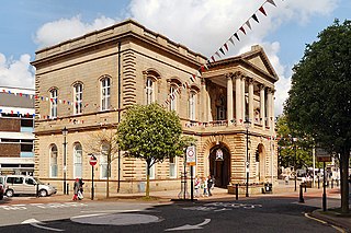
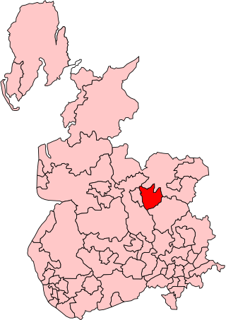
Hyndburn is a local government district with borough status in Lancashire, England. Its council is based in Accrington and covers the outlying towns of Clayton-le-Moors, Great Harwood, Oswaldtwistle and Rishton. The borough was created in 1974 and takes its name from the River Hyndburn. It had a population of 80,734 at the 2011 Census. Elections to the council are held in three out of every four years, with one third of the 35 seats on the council being elected at each election. Both the Conservative and Labour parties have controlled the council at different times, as well as periods when no party has had a majority.

The Borough of Burnley is a local government district with the borough status in Lancashire, England. It has an area of 42.7 square miles (110.7 km2) and a population of 94,646 (2021), and is named after its largest town, Burnley. Other notable settlements include Padiham, Hapton, Worsthorne, Briercliffe and Cliviger.

Clayton-le-Moors is an industrial town in the borough of Hyndburn in the county of Lancashire, England. located two miles north of Accrington. The town has a population of 8,522 according to the 2011 census.
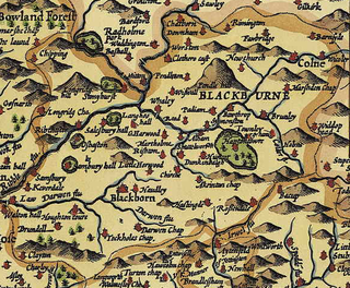
Blackburn Hundred is a historic sub-division of the county of Lancashire, in northern England. Its chief town was Blackburn, in the southwest of the hundred. It covered an area similar to modern East Lancashire, including the current districts of Ribble Valley, Pendle, Burnley, Rossendale, Hyndburn, Blackburn with Darwen, and South Ribble.

Whitebirk is a suburb in the east of Blackburn, in Lancashire, England. Most of the suburb is in Blackburn with Darwen, a unitary area, with the east of the suburb being in the borough of Hyndburn. Whitebirk is part of the Blackburn urban area. The area is largely industrial, and is the eastern terminus of the town's northern bypass, the A6119, where it meets Junction 6 of the M65.

Altham is a village and civil parish in the Borough of Hyndburn, in Lancashire, England. It is the only parish in the borough – the remainder is an unparished area. The village is 4.3 miles (6.9 km) west of Burnley, 2.9 miles (4.7 km) north of Accrington, and 2 miles (3.2 km) north-east of Clayton-le-Moors, and is on the A678 Blackburn to Burnley road.

The River Hyndburn is a minor river in Lancashire, England. Beginning as Woodnook Water on the slopes of Goodshaw Hill, it passes through Stone Fold, Rising Bridge and Baxenden where it is augmented by streams from Thirteen Stone Hill and continues to the Woodnook area of Accrington. Near St James Church, it collects Broad Oak Water, becoming the River Hyndburn. It heads northward through the town centre, collecting Pleck Brook and turning west, flowing under the East Lancashire railway line viaduct and continuing to Church.

Rishton is a town in the Hyndburn district of Lancashire, England, about 2 miles (3 km) west of Clayton-le-Moors and 4 miles (6 km) north east of Blackburn. It was an urban district from about 1894 to 1974. The population at the census of 2011 was 6,625.
Accrington was a parliamentary constituency of the House of Commons of the Parliament of the United Kingdom from 1885 to 1983. It elected one Member of Parliament (MP) by the first-past-the-post system of election.

The River Calder is a major tributary of the River Ribble in Lancashire, England and is around 20 miles (32 km) in length.

Hyndburn Brook is a minor river in eastern Lancashire. It is approximately 4.5 miles (7.3 km) long, and has the catchment area of 13.61 square miles (35.243 km2).

The A671 is a road in the North West of England, that runs between Oldham, Greater Manchester and Worston, near Clitheroe, Lancashire. Major towns on the route include Rochdale and Burnley. The road is approximately 35 miles (56 km) long. Between Burnley and the A59, the A671 has primary status.

Ightenhill is a civil parish in the Borough of Burnley in Lancashire, England, with a population of 1,975.

Hapton is a village and civil parish in the Borough of Burnley in Lancashire, England, 3 miles (4.8 km) west of Burnley, with a railway station on the East Lancashire Line. At the United Kingdom Census 2011, it had a population of 1,979.

The Burnley Way is a 40-mile (64 km) long distance footpath in Lancashire, England. As a circular walk it can be walked from any point, but it is common to start and finish at the Weavers' Triangle Visitor Centre in Burnley. It covers a range of terrain from canal towpaths to open moorland.

A by-thirds Hyndburn Borough Council local election took place on 5 May 2016. Approximately one third of the local council's 35 seats fell up for election on that day. The following year sees Lancashire County Council elections for all residents of this borough.
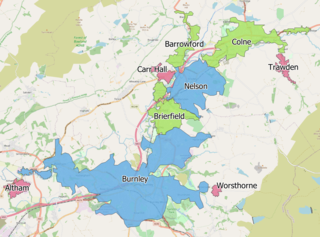
The Burnley Built-up area is an urban area or conurbation which extends from the town of Burnley to Padiham, Brierfield, Nelson, Barrowford and Colne in Lancashire, England. The area takes in parts of the boroughs of Burnley and Pendle, and also small parts of Hyndburn and Ribble Valley. It also includes a number of villages such as Blacko, Trawden and Worsthorne. In 2011 the area was recorded at having a population of 149,422. It is the third most populous urban area in Lancashire after Preston and Blackpool, with slightly more people than the urban areas of Cambridge or York.