
Thornbury is an area of Bradford, in West Yorkshire, England on the border with the City of Leeds. Thornbury is located in the Bradford Moor ward and the Bradford East parliamentary constituency. Thornbury is contiguous with Pudsey – part of the City of Leeds conurbation and borders Laisterdyke, and Fagley.

Bolton and Undercliffe is an electoral ward in the City of Bradford Metropolitan District Council, England. The population of the ward at the 2011 Census was 16,365. Bolton and Undercliffe covers the area east of Bradford Beck, between Shipley & Wrose to the north and central Bradford to the south. It is a largely urban area.

Bradford Moor is an electoral ward within the City of Bradford Metropolitan District Council. The population of the ward at the 2011 Census was 21,210. The ward includes the areas of Laisterdyke and Thornbury.

Eccleshill is an area, former village, and ward within the City of Bradford Metropolitan District Council in the county of West Yorkshire, England. The ward population of Eccleshill is 17,540, increasing at the 2011 Census to 17,945. Eccleshill is a more or less completely residential urban area with very little open space although there is substantial open land directly to the east.

Killinghall is a village and civil parish in the Harrogate district of North Yorkshire, England. The civil parish population taken at the 2011 census was 4,132.

The A6177 is a ring road around Bradford in West Yorkshire, England. It is mostly formed from existing roads and save for its southern section is single-carriageway.

Apperley Bridge is a village in the metropolitan borough of the City of Bradford, in West Yorkshire, England in the Idle and Thackley Ward. Apperley Bridge is north-east of Bradford on the boundary with the City of Leeds bounded in the east by Carr Beck and to the south by Greengates. The village straddles the Leeds and Liverpool Canal and the River Aire. It takes its name from the old bridge over the river on Apperley Lane.

Idle is a residential suburban area in the city of Bradford, West Yorkshire, in England and was a separate village, and before that it was the Manor of Idle. Idle is loosely bordered by the areas of Eccleshill, Wrose, Thackley, Apperley Bridge, and Greengates, in the north-east of the city.

Thackley is a small suburb near Bradford, West Yorkshire in England. The village is loosely bordered by the village of Idle to the south, to the west by the West Royd area of Shipley and elsewhere by the Leeds and Liverpool Canal. Thackley is the northernmost part of Bradford south of the River Aire.

Greengates is a small suburban area in the north-east of the city of Bradford, West Yorkshire, in England. The area is bordered by Idle and Thackley to the north-west, and the large council estate known as Thorpe Edge to the west. To the south of Greengates is Ravenscliffe housing estate with the village of Eccleshill beyond that. The village of Apperley Bridge lies to the north. To the east in the Leeds Metropolitan District is the village of Calverley.
Thackley railway station was a railway station in Thackley, West Yorkshire, England.
Idle railway station was a railway station in Idle, West Yorkshire, England.
Eccleshill railway station was a railway station in Eccleshill, West Yorkshire, England.

Barkerend is an inner-city area in the Bowling and Barkerend ward of the Bradford district, in the English county of West Yorkshire. Barkerend is located to the east of Bradford city centre. The Barkerend area is not easy to define but it is surrounded by Undercliffe, and Undercliffe Cemetery, Bradford Moor, Laisterdyke, Bowling, Broomfields, Little Germany and the Shipley Airedale Road, and Wapping but includes an area of new and modern housing known as Pollard Park.
Dudley Hill is a village in the borough of City of Bradford, West Yorkshire, England and is in Tong ward.
The Shipley Great Northern Railway branch line was a railway line that ran east, south and then westwards from Shipley to Bradford in West Yorkshire. The route was opened in 1874 to goods traffic and then to passengers in 1875 by the Great Northern Railway (GNR) and looped around the eastern edge of Bradford. The GNR arrived after other railways had been established in the West Yorkshire area and many of their lines were heavily reliant on tunnels and grand viaducts, the Shipley and Windhill line being an exception to this, although it did have some steep gradients. The branch extended for 8.5 miles (13.7 km) between the two termini of Shipley Windhill and Bradford Exchange. The route as built from Laisterdyke to Shipley was actually only 6.5 miles (10.5 km) as the initial section from Bradford Exchange to Laisterdyke was already in existence as part of the Great Northern Railway's line to Leeds.

The Leeds, Bradford and Halifax Junction Railway (LB&HJR) was an English railway company. It built a line between Bradford and Leeds, and had running powers over the Lancashire and Yorkshire Railway to Halifax. It opened its main line in 1854 and later built a number of branch lines.
Bradford Corporation Tramways were a tramway network in the city of Bradford, West Riding of Yorkshire, England which operated trams from 1882 until 1950 and trolleybuses from 1911 until 1972. The track gauge of the tramways was 4 ft.
Bradford Moor is a ward in the metropolitan borough of the City of Bradford, West Yorkshire, England. It contains six listed buildings that are recorded in the National Heritage List for England. All the listed buildings are designated at Grade II, the lowest of the three grades, which is applied to "buildings of national importance and special interest". The ward is to the east of the centre of Bradford, and includes the districts of Laisterdyke and Thornbury. It is mainly residential, and the listed buildings consist of a farmhouse and farm buildings, a chaplaincy with an attached stable block and coach house, a former Sunday school, and two rows of terraced cottages.

 The old Yorkshire Bank now an Asian clothes shop
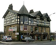 Former Coach and Horses pub, now an Asian clothes shop
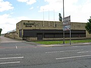 Bowers Group engineering works


