Oxenhope

Last updated

Oxenhope
Oxenhope070805.jpg
Oxenhope, West Yorkshire
West Yorkshire UK location map.svg
Red pog.svg
Oxenhope
Location within West Yorkshire
Population2,626 (2011 census) [1]
OS grid reference SE032351
Civil parish
  • Oxenhope
Metropolitan borough
Metropolitan county
Region
Country England
Sovereign state United Kingdom
Post town KEIGHLEY
Postcode district BD22
Dialling code 01535
Police West Yorkshire
Fire West Yorkshire
Ambulance Yorkshire
UK Parliament
List of places
UK
England
Yorkshire
53°48′43″N1°57′07″W / 53.812°N 1.952°W / 53.812; -1.952

Oxenhope is a village and civil parish near Keighley in the metropolitan borough of Bradford, West Yorkshire, England. It was historically part of the West Riding of Yorkshire. The population was 2,476 at the time of the 2001 census [2] which had increased to 2,626 at the 2011 Census. [1] Oxenhope railway station is the terminus for the Keighley and Worth Valley Railway.

Contents

History

Oxenhope's name derives from the Old English hop which means valley head, so Oxenhope literally means Oxen Valley Head. [3] The industrialisation of the village came about through the cloth and wool trade and by 1850, Oxenhope was host to over 20 mills.

Leeming Reservoir was constructed between 1872 and 1873 to supply the many mills in the area. Its construction necessitated the closure and demolition of at least two mills and their associated houses.

The modern village of Oxenhope encompasses what were originally the separate settlements of Uppertown, Lowertown, Leeming and Horkinstone. The historic hamlets of Marsh and Shaw are also included in the village. The area became known as Oxenhope when the Railway Company named the station serving the area opened the line from Keighley in 1867. Until then, the name Oxenhope referred to a small settlement between the hamlet of Marsh and Haworth.

The street pattern of Oxenhope was much altered when the railway arrived. It had originally been intended that the railway would terminate at Haworth; however the owners of Lowertown Mill in Oxenhope persuaded the railway company to extend the line. It was found impracticable to take the railway as far as Lowertown because of the gradients that would have been required. As a compromise, the railway built a road from its station to Lowertown, appropriately named Station Road. The bridge by which this road crosses Leeming Water is of the same construction as many of the railway's bridges.

Culture

The village hosts a number of annual events including a village show, a beer festival (organised by Keighley and Worth Valley Railway) and a music festival at a village pub.

Each summer the village holds an annual Straw Race. The race was inaugurated in 1976 [4] and since then has raised £300,000 for charity from its participants via sponsorship. [5] Competitors are required to carry a bale of straw (20 kg) 2+12 miles (4.0 km) between five public houses in the Oxenhope area (including the Waggon and Horses, The Bay Horse and The Lamb [6] ) and drink a beer in each pub. The last stretch to the Dog & Gun Pub is 1+12 miles (2.4 km) uphill, past Leeming Reservoir. [7] Many of the competitors wear fancy dress.

On 6 July 2014, Stage 2 of the 2014 Tour de France from York to Sheffield, passed through the village. [8] The subsequent Tour de Yorkshire cycling event has also passed through the village in 2015, 2017 and 2018.

Transport

Oxenhope railway station platform, 2006 227113 20f9b0cdThePlatformOxenhopeRailwayStationTerminusOfTheKeighley&WorthValleyRailway(NigelHomer)Aug2006.jpg
Oxenhope railway station platform, 2006

Road

The A6033 is the main road through the village. It leaves the A629 at Cross Roads and stays quite high up on the east side of the valley, bypassing the village of Haworth and eventually descending into Oxenhope, before going south-east over Oxenhope Moor to Hebden Bridge.

Bus

Transdev bus services operate to Oxenhope and beyond on an hourly basis from Keighley via Haworth. Some routes travel via Oxenhope Moor to Hebden Bridge. [9]

Rail

Oxenhope is the terminus of the Keighley and Worth Valley Railway. This route was closed by British Rail in 1962; then reopened by a group of volunteers 1968. [10] Trains are often steam hauled and run as a heritage rather than a commuter railway. [11]

Religious sites

There are two Methodist churches in Oxenhope; one in the village and one in Marsh hamlet north-west of Oxenhope. Both of these churches are in the Airedale Methodist Circuit. [12] There used to be a Baptist church on Moorside Lane (Hawksbridge Baptist Church) but its congregation dwindled and in 2012 it was put up for sale. The buildings were sold and were featured on Channel 4's The Restoration Man TV show in early 2016. [13]

The Church of England 19th-century parish church of St Mary the Virgin is on Hebden Bridge Road and has some interesting glass by the William Morris company. The church was founded by the Reverend Joseph Brett Grant at the behest of the Reverend Patrick Brontë. The Rev Grant was tireless in collecting money to fund the building of the church and Charlotte Brontë records that he wore out 80 pairs of shoes in his quest to do so. The foundation stones of the church were laid down in 1849. [14]

Notable people

Filmography

Oxenhope was used as setting for the film The Railway Children (starring Jenny Agutter). The Waterbury's house was set at Bents Farm, [16] south of Haworth.

The station was also used in the TV mini series The Great Train Robbery (starring Luke Evans) in 2013.

See also

Related Research Articles

<span class="mw-page-title-main">Keighley & Worth Valley Railway</span> Heritage line in West Yorkshire, England

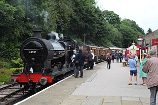
The Keighley & Worth Valley Railway (KWVR) is a 5-mile-long (8 km) heritage railway in the Worth Valley, West Yorkshire, England, which runs from Keighley to Oxenhope. It connects to the National Rail network at Keighley railway station.

<span class="mw-page-title-main">Haworth</span> Village in West Yorkshire, England

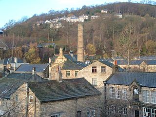
Haworth is a village in West Yorkshire, England. Located in the Pennines, Haworth is 3 miles (5 km) south-west of Keighley, 8 miles north of Halifax, 10 miles (16 km) west of Bradford and 10 miles (16 km) east of Colne in Lancashire. The surrounding areas include Oakworth and Oxenhope. Nearby villages include Cross Roads, Stanbury and Lumbfoot.

<span class="mw-page-title-main">Keighley</span> Market town and civil parish in West Yorkshire, England

Keighley is a market town and a civil parish in the City of Bradford Borough of West Yorkshire, England. It is the second largest settlement in the borough, after Bradford.

<span class="mw-page-title-main">Stanbury</span> Village in West Yorkshire, England

Stanbury is a village and former civil parish, now in the parish of Haworth and Stanbury, in the metropolitan borough of the City of Bradford in West Yorkshire, England. In 1931 the parish had a population of 453. The name Stanbury translates as Stone Fort from Old English.

<span class="mw-page-title-main">River Worth</span> River in West Yorkshire, England

The River Worth is a river in West Yorkshire, England. It flows from minor tributaries on the moors above Watersheddles Reservoir down the Worth Valley to Haworth, where it is joined by Bridgehouse Beck which flows from Oxenhope. The River Worth is itself a tributary of the River Aire, which it joins at the end of the Worth Valley in Keighley.

<span class="mw-page-title-main">Worth Valley</span> Local council ward in West Yorkshire, England

Worth Valley is a ward in the City of Bradford Metropolitan District Council, West Yorkshire. The population of the ward taken at the 2011 Census was 14,387. It is named after the River Worth that runs through the valley to the town of Keighley where it joins the River Aire. In the north it is bounded by North Yorkshire, in the west by Lancashire and in the south by Calderdale District.

<span class="mw-page-title-main">Keighley railway station</span> Railway station in West Yorkshire, England

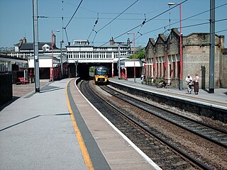
Keighley railway station serves the market town of Keighley in West Yorkshire, England. The station is located on the Airedale line, with electric services to Leeds, Skipton and Bradford Forster Square provided by Northern, along with longer distance services to Morecambe and Carlisle. The station is split in half, with National Rail operating from platforms 1 and 2, while platforms 3 and 4 are the northern terminus of heritage services to Oxenhope on the Keighley & Worth Valley Railway.

<span class="mw-page-title-main">Ingrow</span> Suburb of Keighley, West Yorkshire, England

Ingrow is a suburb of Keighley, West Yorkshire, England that lies on the River Worth. The name Ingrow comes from Old Scandinavian which means 'corner of land in the meadow.' The suburb is located on the A629 road and is 0.93 miles (1.5 km) south west of Keighley town centre.

<span class="mw-page-title-main">Hebden Royd</span> Town and Civil Parish in West Yorkshire, England

Hebden Royd is a civil parish in the Metropolitan Borough of Calderdale in West Yorkshire, England. According to the 2001 census it had a population of 9,092, rising to 9,558 at the 2011 census. It includes market town of Hebden Bridge and the villages of Mytholmroyd and Cragg Vale. The parish was an urban district before 1974, created in 1937 by the merger of Hebden Bridge and Mytholmroyd urban districts.

<span class="mw-page-title-main">Haworth railway station</span> Railway station in West Yorkshire, England

Haworth railway station serves the village of Haworth in West Yorkshire, England.

<span class="mw-page-title-main">Oxenhope railway station</span> Railway station in West Yorkshire, England

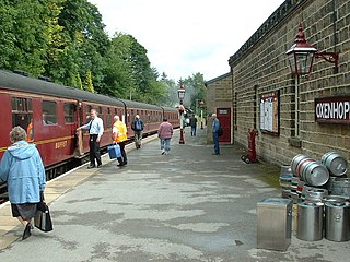
Oxenhope railway station serves the village of Oxenhope, near Haworth, and within the City of Bradford Metropolitan District of West Yorkshire, England. It is the terminus of the Keighley & Worth Valley Railway, with trains to Haworth and Keighley.

<span class="mw-page-title-main">South Pennines</span> Region of moorland and hills in northern England

The South Pennines is a region of moorland and hill country in northern England lying towards the southern end of the Pennines. In the west it includes the Rossendale Valley and the West Pennine Moors. It is bounded by the Greater Manchester conurbation in the west and the Bowland Fells and Yorkshire Dales to the north. To the east it is fringed by the towns of West Yorkshire whilst to the south it is bounded by the Peak District. The rural South Pennine Moors constitutes both a Site of Special Scientific Interest and Special Area of Conservation.

<span class="mw-page-title-main">Cross Roads, West Yorkshire</span> Village in West Yorkshire, England

Cross Roads or Cross Roads with Lees or Cross Roads cum Lees is a village and civil parish within the City of Bradford Metropolitan District, West Yorkshire, England. Historically part of the West Riding of Yorkshire, it lies less than 1 mile (1.6 km) from Haworth, approximately 2.5 miles (4 km) from Keighley and approximately 9 miles (14 km) from Bradford.

<span class="mw-page-title-main">St Michael and All Angels' Church, Haworth</span> Church of England church in West Yorkshire, England

St Michael and All Angels' Church is the Church of England parish church of Haworth, West Yorkshire. The current structure, the third church building on the site, was built between 1879 and 1881 although parts of the original medieval church building, notably the tower, survive from earlier periods.

<span class="mw-page-title-main">Damems</span> Village in West Yorkshire, England

Damems is a village near Keighley, within the City of Bradford Metropolitan District, West Yorkshire, England. It is in the BD22 postcode area and uses the 01535 dialling code. Until the mid-19th century it was also known as Dam Elms or Dam Ems.

The Rolling stock of the Keighley & Worth Valley Railway is used on the preserved Keighley & Worth Valley Railway, a 5-mile-long (8 km) branch line that served mills and villages in the Worth Valley and is now a heritage railway line in West Yorkshire, England. It runs from Keighley to Oxenhope. It connects to the national rail network line at Keighley railway station.

<span class="mw-page-title-main">Lower Laithe Reservoir</span> Reservoir in West Yorkshire, England

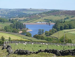
Lower Laithe Reservoir is a man-made upland reservoir that lies 1.2 miles (2 km) west of Haworth, West Yorkshire, England. The reservoir was initially approved under the Keighley Waterworks and Improvement Act of 1869 but work did not begin on its construction until 1911 and even then was delayed because of the First World War. The reservoir was officially opened in August 1925 in front of a crowd of over 8,000 people. Its final tally on cost was £500,000. The reservoir lies in the Sladen Valley and was often referred to as Sladen Valley Reservoir.

<span class="mw-page-title-main">Penistone Hill Country Park</span> Moorland park in West Yorkshire, England

Penistone Hill Country Park is an open space of moorland that is located to 0.31 miles (0.5 km) west of Haworth and 0.62 miles (1 km) north-west of Oxenhope in West Yorkshire, England. The park's highest point is detailed with a trig point which is 1,030 feet (310 m) above sea level. Since 1994, the park has been notified as being an SSSI as part of the South Pennine Moors.

<span class="mw-page-title-main">Hainworth</span> Hamlet in West Yorkshire, England

Hainworth is a hamlet 1 mile (2 km) south of Keighley in West Yorkshire, England. The hamlet faces north across the lower end of the Worth Valley with a steep wooded incline towards Keighley.

<span class="mw-page-title-main">Worth Valley (dale)</span> Valley in West Yorkshire, England

The Worth Valley is a geographic area in West Yorkshire, England, that extends eastwards from Crow Hill and Oxenhope Moor, providing drainage for the River Worth for nearly 10 miles (16 km) to the River Aire. It is a side valley to Airedale, with the River Worth being a major tributary of the River Aire. The Worth Valley was important for its contribution to the textiles industry of the West Riding of Yorkshire and was furnished with several reservoirs to allow mills to operate within the valley. Most of the reservoirs are still in use into the modern day.

References

  1. 1 2 UK Census (2011). "Local Area Report – Civil Parish population 2011 (E04000161)". Nomis. Office for National Statistics . Retrieved 6 March 2019.
  2. UK Census (2001). "Local Area Report – Oxenhope Parish (00CX005)". Nomis. Office for National Statistics . Retrieved 18 May 2019.
  3. "Oxenhope; Assessment of Conservation Areas" (PDF). bradford.gov.uk. 2004. p. 7. Retrieved 10 April 2019.
  4. "Keighley News Oxenhope Straw Race 2014".
  5. "About | The Oxenhope Straw Race". oxenhopestrawrace.com. Retrieved 20 August 2023.
  6. "The Lamb Inn". www.lamb-oxenhope.co.uk. Retrieved 20 August 2023.
  7. "Rules & Regulations | The Oxenhope Straw Race". oxenhopestrawrace.com/rules/. Retrieved 20 August 2023.
  8. "Tour de France Stage 1". Archived from the original on 25 July 2014. Retrieved 15 July 2014.
  9. "Transdev Keighley & district route 500" (PDF).
  10. "History | KWVR – Keighley & Worth Valley Railway". KWVR – Keighley & Worth Valley Railway. Retrieved 21 October 2015.
  11. "Worth Valley Railway Timetable".
  12. "Welcome to the Airedale Circuit | Airedale Circuit". www.airedalemethodists.org. Retrieved 22 October 2015.
  13. "Oxenhope's former Hawksbridge Baptist Chapel to feature in Restoration Man TV show". Keighley News. Retrieved 22 October 2015.
  14. "Oxenhope, West Yorkshire – St. Mary the Virgin – History". www.thesunflowertrust.org.uk. Retrieved 22 October 2015.
  15. Knights, David (3 February 2011). "Between the devil and the Deep Blue Sea". Keighley News . Retrieved 31 January 2024.
  16. "The Railway Children: in search of the Yorkshire locations, 50 years on". BFI. Retrieved 20 August 2023.