
Perry County is a county in the U.S. state of Kentucky. As of the 2020 census, the population was 28,473. Its county seat is Hazard. The county was founded in 1820. Both the county and county seat are named for Commodore Oliver Hazard Perry, a naval hero in the War of 1812.

Fairburn Ings Nature Reserve is a protected area in West Yorkshire, England, noted for its avian biodiversity. The reserve has recorded around 280 bird species, remarkable for an inland site in the United Kingdom. This is explained by the site being on migration routes as well as the diversity of habitats.

Tong is a ward within the City of Bradford Metropolitan District Council, West Yorkshire, England, named after Tong village which is its oldest settlement. The population at the 2011 Census was 20,608.

Brodsworth Colliery was a coal mine north west of Doncaster and west of the Great North Road. in South Yorkshire, England. Two shafts were sunk between October 1905 and 1907 in a joint venture by the Hickleton Main Colliery Company and the Staveley Coal and Iron Company.

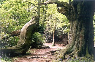
Barnsdale, or Barnsdale Forest, is an area of South and West Yorkshire, England. The area falls within the modern-day districts of Doncaster and Wakefield. Barnsdale was historically part of the West Riding of Yorkshire. Barnsdale lies in the immediate vicinity north and northwest of Doncaster, and which was formerly forested and a place of royal hunts, and also renowned as a haunt of the outlaw Robin Hood in early ballads.
Ecclesall Woods is an area of woodland in south-west Sheffield, South Yorkshire, England, between Abbeydale Road South and Ecclesall. It covers approximately 350 acres (1.4 km2) of mature semi-natural deciduous woodland which was previously used for timber and charcoal, and is currently managed by the city council for the benefit of wildlife and visitor access. There are two roads and over 10 miles (16 km) of public footpaths running through the woods. The Abbeydale miniature railway is also located within the woods.
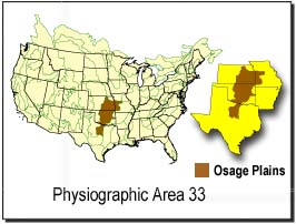
The Osage Plains are a physiographic section of the larger Central Lowland province, which in turn is part of the larger Interior Plains physiographic division. The area is sometimes called the Lower Plains, North Central Plains,or Rolling Plains. The Osage Plains, covering west-central Missouri, the southeastern third of Kansas, most of central Oklahoma, and extending into north-central Texas, is the southernmost of three tallgrass prairie physiographic areas. It grades into savanna and woodland to the east and south, and into shorter, mixed-grass prairie to the west. The Osage Plains consist of three subregions. The Osage Plains proper occupy the northeast segment. Although sharply demarcated from the Ozark uplift, the plains are nonetheless a transitional area across which the boundary between prairie and woodland has shifted over time. In the central portion of the physiographic area lies the second subregion, the Flint Hills, commonly called "the Osage" in Oklahoma. This large remnant core of native tallgrass prairie is a rocky rolling terrain that runs from north to south across Kansas and extends into Oklahoma. To the west and south of these hills are the Blackland Prairies and Cross Timbers. This vegetatively complex region of intermixed prairie and scrubby juniper-mesquite woodland extends into north-central Texas. Bluestem prairies and oak-dominated savannas and woodlands characterize the natural vegetation in the Cross Timbers. Much of the area has been converted to agriculture, although expanses of oak forest and woodland are still scattered throughout the eastern portion of the subregion.
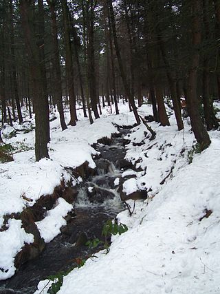
The Limb Brook is a stream in Sheffield, South Yorkshire, England. It rises at the village of Ringinglow, flowing east through Whirlow and Ecclesall Woods into Abbeydale in the Beauchief area, where it merges with the River Sheaf. Near this point part of the stream has been diverted to provide the goit for the Abbeydale Industrial Hamlet millpond, and this channel flows through what is now Beauchief Gardens.
The Heaton Woods Trust is both the name for the charity and the woodland it cares for located mainly in Heaton, Bradford, West Yorkshire, England but also stretches into Shipley. The Heaton Woods Trust is a registered charity that was established in 1977. The Heaton Woods Trust is responsible for the care and protection of the woods for the benefit of present and future generations.
Silverwood Colliery was a colliery situated between Thrybergh and Ravenfield in Yorkshire, England. Originally called Dalton Main, it was renamed after a local woodland. It was owned by Dalton Main Collieries Ltd.

The geography of Greater Manchester is dominated by one of the United Kingdom's largest metropolitan areas, and in this capacity the landlocked metropolitan county constitutes one of the most urbanised and densely populated areas of the country. There is a mix of high density urban areas, suburbs, semi-rural and rural locations in Greater Manchester, but overwhelmingly the land use in the county is urban.

Selby coalfield was a large-scale deep underground mine complex based around Selby, North Yorkshire, England, with pitheads at Wistow Mine, Stillingfleet Mine, Riccall Mine, North Selby Mine, Whitemoor Mine and at Gascoigne Wood Mine; all coal was brought to the surface and treated at Gascoigne Wood, being distributed onwards by rail. The primary purpose of the pit was to supply coal for electrical power generation; much of it was used in the nearby Aire valley power stations.
Severn Valley Country Park is a country park in England, located near Alveley, Shropshire, 8 miles (13 km) from Bridgnorth, 7 miles from Kidderminster, roughly central in the Severn Valley. Originally the site of a huge coal mine, it is now a 126-acre (51 ha) park consisting of woodland, meadows and riverside banks with views over the River Severn and a Green Flag Award.

The Weavers' Triangle is an area of Burnley in Lancashire, England consisting mostly of 19th-century industrial buildings at the western side of town centre clustered around the Leeds and Liverpool Canal. The area has significant historic interest as the cotton mills and associated buildings encapsulate the social and economic development of the town and its weaving industry. From the 1980s, the area has been the focus of major redevelopment efforts.

Brockholes is a nature reserve near Preston, Lancashire, England, just off Junction 31 of the M6 motorway. It is owned by the Wildlife Trust for Lancashire, Manchester and North Merseyside. Situated in the flood-plain of the river Ribble, it has the UK's first floating visitor village.

Bispham Hall is a Grade II* listed Elizabethan country house in Billinge, now part of the Metropolitan Borough of Wigan, Greater Manchester.

Grimeshaw Wood is a 16.8-hectare (42-acre) Local Nature Reserve on the western outskirts of Peterborough in Cambridgeshire. It is owned by Peterborough City Council, and managed by the council together with the Peterborough Environment City Trust.

Oakley Wood is a 48.1-hectare (119-acre) biological Site of Special Scientific Interest west of Hathern in Leicestershire.

Pasture and Asplin Woods is a 40.9 hectares biological Site of Special Scientific Interest west of Belton in Leicestershire.

The Burnley Coalfield is the most northerly portion of the Lancashire Coalfield. Surrounding Burnley, Nelson, Blackburn and Accrington, it is separated from the larger southern part by an area of Millstone Grit that forms the Rossendale anticline. Occupying a syncline, it stretches from Blackburn past Colne to the Yorkshire border where its eastern flank is the Pennine anticline.

