Greengates

Last updated

West Yorkshire UK location map.svg
Red pog.svg
Greengates
Location within West Yorkshire
OS grid reference SE1837
Metropolitan borough
Metropolitan county
Region
Country England
Sovereign state United Kingdom
Post town BRADFORD
Postcode district BD10
Dialling code 01274
Police West Yorkshire
Fire West Yorkshire
Ambulance Yorkshire
List of places
UK
England
Yorkshire
53°49′53″N1°42′44″W / 53.831428°N 1.712172°W / 53.831428; -1.712172

Greengates is a small suburban area in the north-east of the city of Bradford, West Yorkshire, in England. The area is bordered by Idle and Thackley to the north-west, and the large council estate known as Thorpe Edge to the west. To the south of Greengates is Ravenscliffe housing estate with the village of Eccleshill beyond that. The village of Apperley Bridge lies to the north. To the east in the Leeds Metropolitan District is the village of Calverley.

Contents

History

Bradford Trolley Bus on Albion Road Bradford Trolleybus in Albion Road, Greengates - geograph.org.uk - 1463102.jpg
Bradford Trolley Bus on Albion Road

To the west of Greengates is Albion Mills a historic textile mill, destroyed by fire on 10 March 1911 but rebuilt. [1] [2] In 1931 the Bradford trolleybus routes were extended from Idle to Greengates [3] with the service running along Albion Road and Leeds Road.

In 1928 a purpose-built 595 seat cinema 'Greengates Cinema' was constructed on New Line for the Greengates Cinema Company. This closed in 1959 and is now an Asda supermarket. [4]

Governance

Greengates is situated largely in the Idle and Thackley ward and partly in the Eccleshill ward. It is represented as part of the parliamentary constituency of Bradford East.

Economy

Albion Mills Business Centre (part of) Albion Mills Business Centre-1200.jpg
Albion Mills Business Centre (part of)

Greengates' proximity to the Leeds and Liverpool Canal, that runs through Apperley Bridge to the north of the village, has meant that Greengates has several mills. At the western end is Robin Mills and Albion Mills. Robin Mills was a base for manufacturing knitting wool yarns but is now split into industrial units. A large part of Robin Mills is occupied by Storey Evans, carton, leaflet, label etc. printers for the pharmaceutical industry. [5] Albion Mills is split into office accommodation and business units. There is the racing car themed Speedmaster Conference Centre, until recently notable for its classic, competition and racing car showroom and exhibition. The centre was opened in April 2008 by Sir Stirling Moss. [6]

On New Line, is the New Line Retail Park with a Subway, a veterinary surgery, Boots Chemist, and a beauty shop. A little past the New Line retail park is Rainbows nursery, the New Line micro pub that sits beside the New Line Auto Garage. Eastwards between Harrogate Road and New Line in Greengates Retail Park is a Sainsbury's, B&M, Argos, Matalan, Costa, KFC. [7] and Core Gym. Existing historic public houses in the area include The Albion and The Hogs Head. [8] The Seven Stars is now an Italian restaurant (Aldos), and The Roebuck public house was demolished to make way for a new Farmfoods store. The Cracker Barrel micro pub opened in April 2017, in the former Post Office on Harrogate Road. There is also the Kebabeesh, Kiplings, Bhajis & Beer Indian restaurants. Also has two Chinese takeaways (China Garden and Empires Chinese), along with a Fish and Chip shop.

Landmarks

The area is centred on the crossroads of Leeds Road/New Line, and Harrogate Road. Around this crossroads are most of the area's pubs, restaurants and shops, a Sainsbury's supermarket, Homebase, Argos and a Matalan. Another feature is the large war memorial situated at the crossroads, that commemorates those who died in World War I and World War II from Greengates and the surrounding villages. [9] [10] On Harrogate Road to the north of the main crossroads there is a large Anglican church dedicated to St. John the Evangelist. [11] Along this stretch of the Harrogate Road is Optegra Yorkshire Eye Hospital and Bettersight Advanced Eye and Vision Consultancy. [12] The post office is on New Line. [13]

There are a number of listed buildings in Greengates. [14] These are to be found at Beck Bottom, [15] Carr Bottom Road, [16] Haigh Hall, [17] Harrogate Road, [18] New Line [19] and Stockhill Fold. [20]

Education

Greengates has its own primary school, Greengates Primary School, that moved northwards out of an older building on Leeds Road, to a new building across the road. [21] The old school building has now been transformed into fashion business premises. Parkland Primary school, immediately behind Albion Mills, also serves Greengates and the neighbouring Thorpe Edge estate. [22]

Transport

The following bus services run to Greengates; 645: (First Bradford) Buttershaw - Greengates via Five Lane Ends and Bradford City Centre,

60: (Keighley Bus Company) Leeds - Keighley via Bingley and Saltaire, 747: (Flying Tiger) [Airport Direct] Bradford - Leeds Bradford Airport - Harrogate

The A657 Leeds Road / New Line runs east–west through Greengates while the A658 Harrogate Road runs approximately north–south. [23] Greengates does not have its own railway station: the nearest station is Apperley Bridge railway station just under a mile to the north. The nearest airport to Greengates is Leeds Bradford Airport and can be accessed by bus service 747.

Notable people

See also

Related Research Articles

<span class="mw-page-title-main">Airedale line</span> Rail line in Yorkshire, England

The Airedale line is one of the rail services in the West Yorkshire Metro area centred on West Yorkshire in northern England. The service is operated by Northern, on the route connecting Leeds and Bradford with Skipton. Some services along the line continue to Morecambe or Carlisle. The route covered by the service was historically part of the Midland Railway.

<span class="mw-page-title-main">Bolton and Undercliffe</span> Human settlement in England

Bolton and Undercliffe is an electoral ward in the City of Bradford Metropolitan District Council, England. The population of the ward at the 2011 Census was 16,365. Bolton and Undercliffe covers the area east of Bradford Beck, between Shipley & Wrose to the north and central Bradford to the south. It is a largely urban area.

<span class="mw-page-title-main">Eccleshill, Bradford</span> Area of Bradford, West Yorkshire, England

Eccleshill is an area, former village, and ward within the City of Bradford Metropolitan District Council in the county of West Yorkshire, England. The ward population of Eccleshill is 17,540, increasing at the 2011 Census to 17,945. Eccleshill is a more or less completely residential urban area with very little open space although there is substantial open land directly to the east.

<span class="mw-page-title-main">Idle and Thackley</span> Human settlement in England

Idle and Thackley is a ward within the City of Bradford Metropolitan District Council in the county of West Yorkshire, England, named after the villages of Idle and Thackley around which it is drawn. The population of 14,541 according to the 2001 UK census had increased at the 2011 Census to 16,135.

<span class="mw-page-title-main">Shipley and Windhill railway station</span> Disused railway station in West Yorkshire, England

Shipley and Windhill railway station was a railway station in Shipley, West Yorkshire, England between 1875 and 1931.

<span class="mw-page-title-main">Apperley Bridge railway station</span> Railway station in West Yorkshire, England

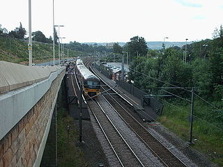
Apperley Bridge station is situated in Bradford on the line between Leeds and Shipley, West Yorkshire, England. It serves the district of Apperley Bridge in the north-east of the city.

<span class="mw-page-title-main">Apperley Bridge</span> Village in West Yorkshire, England

Apperley Bridge is a village in the metropolitan borough of the City of Bradford, in West Yorkshire, England in the Idle and Thackley Ward. Apperley Bridge is north-east of Bradford on the boundary with the City of Leeds bounded in the east by Carr Beck and to the south by Greengates. The village straddles the Leeds and Liverpool Canal and the River Aire. It takes its name from the old bridge over the river on Apperley Lane.

<span class="mw-page-title-main">Idle, West Yorkshire</span> Area of Bradford in west Yorkshire, England

Idle is a residential suburban area in the city of Bradford, West Yorkshire, in England and was a separate village, and before that it was the Manor of Idle. Idle is loosely bordered by the areas of Eccleshill, Wrose, Thackley, Apperley Bridge, and Greengates, in the north-east of the city.

<span class="mw-page-title-main">Thackley</span> Village in West Yorkshire, England

Thackley is a small suburb near Bradford, West Yorkshire in England. The village is loosely bordered by the village of Idle to the south, to the west by the West Royd area of Shipley and elsewhere by the Leeds and Liverpool Canal. Thackley is the northernmost part of Bradford south of the River Aire.

<span class="mw-page-title-main">A658 road</span> A-road in Yorkshire, England

The A658 is a road in Yorkshire, UK.

Thackley railway station was a railway station in Thackley, West Yorkshire, England.

Laisterdyke is an area of Bradford, West Yorkshire, England, situated to the east of the city on the border with City of Leeds and located in the Bradford Moor ward and in the Bradford East parliamentary constituency. Laisterdyke borders Barkerend, Bradford Moor area, Thornbury, Tyersal, and Bowling.

<span class="mw-page-title-main">Ravenscliffe, West Yorkshire</span>

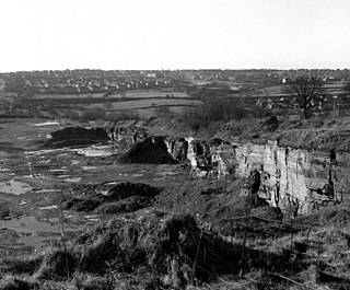
Ravenscliffe is a housing estate in the Eccleshill ward of the city of Bradford District, in the English county of West Yorkshire. Ravenscliffe is located to the west of Fagley Beck and to the east of the A658 Harrogate Road. The buildings that were Ravenscliff farmhouse are situated off to the south in Fagley while Ravenscliffe Woods are in Pudsey to the south east.

Dudley Hill is a village in the borough of City of Bradford, West Yorkshire, England and is in Tong ward.

<span class="mw-page-title-main">Shipley Great Northern Railway branch line</span> Disused railway line in West Yorkshire, England

The Shipley Great Northern Railway branch line was a railway line that ran east, south and then westwards from Shipley to Bradford in West Yorkshire. The route was opened in 1874 to goods traffic and then to passengers in 1875 by the Great Northern Railway (GNR) and looped around the eastern edge of Bradford. The GNR arrived after other railways had been established in the West Yorkshire area and many of their lines were heavily reliant on tunnels and grand viaducts, the Shipley and Windhill line being an exception to this, although it did have some steep gradients. The branch extended for 8.5 miles (13.7 km) between the two termini of Shipley Windhill and Bradford Exchange. The route as built from Laisterdyke to Shipley was actually only 6.5 miles (10.5 km) as the initial section from Bradford Exchange to Laisterdyke was already in existence as part of the Great Northern Railway's line to Leeds.

<span class="mw-page-title-main">Little London, West Yorkshire</span> Village in West Yorkshire, England

Little London is a village in West Yorkshire, England, that is divided between the Guiseley and Rawdon and the Horsforth wards of the City of Leeds and the Idle and Thackley ward of the City of Bradford. It comprises a conservation area in the westernmost part of Rawdon town which is unique in that the historic area covered by the designation straddles the boundary of districts of Leeds and of neighbouring Bradford. Apperley Lane (A658) forms the municipal boundary.

<span class="mw-page-title-main">Thorpe Edge</span> Suburb of Bradford, West Yorkshire, England

Thorpe Edge is a housing estate in Idle, Bradford, West Yorkshire, England.

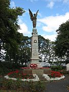
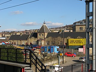
Eccleshill is a ward in the metropolitan borough of the City of Bradford, West Yorkshire, England. It contains 30 listed buildings that are recorded in the National Heritage List for England. All the listed buildings are designated at Grade II, the lowest of the three grades, which is applied to "buildings of national importance and special interest". The ward is to the northeast of the centre of Bradford, and contains the former village of Eccleshill and the surrounding area, including the districts of Fagley and Greengates. Most of the listed buildings are houses, cottages and associated structures, farmhouses and farm buildings. The other listed buildings consist of a former chapel, a church, and a former mechanics' institute.

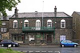
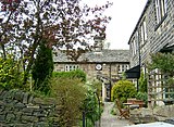
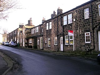
Idle and Thackley is a ward in the metropolitan borough of the City of Bradford, West Yorkshire, England. It contains 131 listed buildings that are recorded in the National Heritage List for England. Of these, two are listed at Grade II*, the middle of the three grades, and the others are at Grade II, the lowest grade. As well as the villages of Idle and Thackley, the ward includes the villages of Apperley Bridge and Greengates, and the surrounding area. The southern part of the ward is mainly residential, and the northern part is mainly rural. Most of the listed buildings are houses, cottages and associated structures, farmhouses and farm buildings. The other listed buildings include public houses, a church, a bridge, an archway to a former burial ground, a former toll house, a pair of locks on the Leeds and Liverpool Canal and an adjacent depot building, a war memorial, and a telephone kiosk.

<span class="mw-page-title-main">Flyer (bus service)</span>

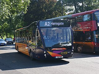
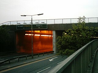
Flyer is the current brand name of a trio of bus services that call at Leeds Bradford Airport in England. Numbered A1, A2 and A3, the routes serve a range of towns and cities in Yorkshire including Leeds, Bradford and Harrogate.

References

  1. "History of Bradford, Yorkshire - 1900 to 1949". Bradford Timelines. Retrieved 14 March 2010.
  2. White, Eileen (1997). Idle Stones. Idle and Thackley Heritage Group.
  3. Gould, Peter. "Bradford City Transport: 1898-1974". Bradford Corporation Transport: 1898-1974. Archived from the original on 14 February 2010. Retrieved 14 March 2010.
  4. Sutton, Colin. "Bradford - Greengates Cinema History". Bradford Timeline. Retrieved 30 October 2015.; "Greengates Cinema in Bradford". Cinema Treasures. Retrieved 28 April 2013.
  5. Morris, Helen (23 December 2008). "MY Healthcare strengthens position with Storey Evans acquisition". printweek.com. Archived from the original on 15 July 2011. Retrieved 15 February 2011.
  6. "Speedmaster Conference Centre". Destination Bradford. 2008. Archived from the original on 15 August 2011. Retrieved 14 March 2010.; "Sir Stirling Moss OBE Drove famous Jaguar D-Type through Bradford". Classic Rallies.com. 29 April 2008. Archived from the original on 8 July 2011. Retrieved 14 March 2010.
  7. Jack Lunn Group (2008). "Greengates Retail Park". Jack Lunn Construction. Archived from the original on 10 November 2013. Retrieved 28 April 2013.
  8. "Pubs in Greengates". Pubs Galore. Retrieved 18 June 2015.
  9. Greengates War Memorial. "Greengates War Memorial". Calverley Info. Retrieved 17 July 2008.
  10. "Greengates War Memorial". Bradford Parks & Landscape Service. Retrieved 14 March 2010.
  11. "Greengates: St John the Evangelist". The Church of England. Retrieved 14 March 2010.
  12. Choices, N.H.S. (29 September 2009). "Optegra Eye Hospital Yorkshire". NHS Choices. Retrieved 30 October 2016.
  13. "Post Office Greengates". Check Opening Times. Retrieved 30 April 2017.
  14. "Listed Buildings in Bradford, West Yorkshire, England". British Listed Buildings. Retrieved 10 February 2011.
  15. "5". Beck Bottom, British Listed Buildings. Retrieved 11 November 2012.
  16. "16-22".; and "153". Carr Bottom Road, British Listed Buildings. Retrieved 11 November 2012.
  17. "2 & 4".; and "6". Haigh Hall, British Listed Buildings. Retrieved 11 November 2012.
  18. "702 & 704".; "Coach Ho".; "Greengates War Memorial".; "830 Greengates Ho".; "929 & 931". Harrogate Road, British Listed Buildings. Retrieved 11 November 2012.
  19. "159".; "161, 163 & 165".; "169 & 171".; "173 & 175 (Greengates Liberal Club)". New Line, British Listed Buildings. Retrieved 11 November 2012.
  20. "15 (Stockhill Ho.)".; "17".; "19, 21 & 23".; "25 & 27".; "29 & 31".; "33". Stockhill Fold, British Listed Buildings. Retrieved 11 November 2012.
  21. "Greengates Primary School, Bradford". greengatesprimary.org.uk. Retrieved 14 March 2010.[ permanent dead link ]
  22. "Parkland Primary School". 2013. Retrieved 28 April 2013.
  23. Leeds & Bradford A-Z (2 ed.). Geographers' A-Z Map Company Ltd. 2006. ISBN   1-84348-209-6.