
Salisbury is a cathedral city in Wiltshire, England with a population of 41,820, at the confluence of the rivers Avon, Nadder and Bourne. The city is approximately 20 miles from Southampton and 30 miles from Bath.

Haworth is a village in the civil parish of Haworth and Stanbury, in the Bradford district, in the county of West Yorkshire, England, in the Pennines, 3 miles (5 km) south-west of Keighley, 10 miles (16 km) west of Bradford and 10 miles (16 km) east of Colne in Lancashire. The surrounding areas include Oakworth and Oxenhope. Nearby villages include Cross Roads, Stanbury and Lumbfoot.

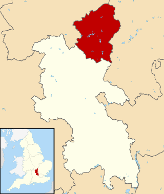
North Yorkshire is a ceremonial county in both the Yorkshire and the Humber region and North East England. It is the largest county of England by land area, at 2,483 square miles (6,430 km2), and has two national parks; the North York Moors and most of the Yorkshire Dales.

Oxenhope is a village and civil parish near Keighley in the metropolitan borough of Bradford, West Yorkshire, England. It was historically part of the West Riding of Yorkshire. The population was 2,476 at the time of the 2001 census which had increased to 2,626 at the 2011 Census. Oxenhope railway station is the terminus for the Keighley and Worth Valley Railway.

Keighley is a market town and a civil parish in the City of Bradford Borough of West Yorkshire, England. It is the second largest settlement in the borough, after Bradford.

Stanbury is a village in the Haworth and Stanbury civil parish, and in the metropolitan borough of the City of Bradford in West Yorkshire, England. The name Stanbury translates as Stone Fort from Old English.
The City of Milton Keynes is a unitary authority area with both borough and city status, in Buckinghamshire. It is the northernmost district of the South East England Region. The borough abuts Bedfordshire, Northamptonshire and the remainder of Buckinghamshire.

The City of Carlisle was a local government district of Cumbria, England, with the status of a city. It was named after its largest settlement, Carlisle, but covered a far larger area which included the towns of Brampton and Longtown, as well as outlying villages including Dalston, Scotby and Wetheral. In 2011 the district had a population of 107,524, and an area of 1,039.97 square kilometres (402 sq mi).

Lumbfoot or Lumb Foot is a hamlet in the Haworth, Cross Roads and Stanbury civil parish, and the City of Bradford metropolitan district, England. It is situated approximately 1 mile (1.6 km) from Haworth and less than half a mile north-east from Stanbury. The hamlet is historically part of the West Riding of Yorkshire. Lumbfoot overlooks a number of fields and a small brook, and contains 15 households and a farm. There is no public road; access is by a private road for vehicles, and a public footpath.

Roos is a village and civil parish in the East Riding of Yorkshire, England. It is situated 12 miles (19 km) east from Kingston upon Hull city centre and 3.5 miles (6 km) north-west from Withernsea, and on the B1242 road.

Allerthorpe is a village and civil parish in the East Riding of Yorkshire, England. It is situated approximately 1.5 miles (2.4 km) south-west from the town of Pocklington.
Rotherfield is a village and civil parish in the Wealden District of East Sussex, England. It is one of the largest parishes in East Sussex. There are three villages in the parish: Rotherfield, Mark Cross and Eridge. The River Rother, which drains much of the county and discharges at Rye Harbour, has its source on the south side of the hill on which Rotherfield village is built.

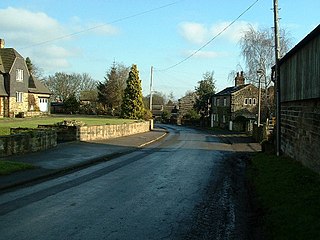
Cross Roads or Cross Roads with Lees or Cross Roads cum Lees is a village and civil parish within the City of Bradford Metropolitan District, West Yorkshire, England. Historically part of the West Riding of Yorkshire, it lies less than 1-mile (1.6 km) from Haworth, approximately 2.5 miles (4 km) from Keighley and approximately 9 miles (14 km) from Bradford.
Woolley is a village and civil parish in the City of Wakefield in West Yorkshire, England. It had a population of 575 in 2001, which increased to 1,339 at the 2011 Census. It is 6 miles (10 km) north of Barnsley, and 7 miles (11 km) south of Wakefield.

Wimbolds Trafford is a hamlet and former civil parish, now in the parish of Mickle Trafford and District, in the unitary authority of Cheshire West and Chester and the ceremonial county of Cheshire, England. The hamlet lies on the B5132 road, approximately 5 miles (8 km) to the north east of Chester and north of the village of Mickle Trafford.

The City of Leeds is a city and metropolitan borough in West Yorkshire, England. The metropolitan borough includes the administrative centre of Leeds and the towns of Farsley, Garforth, Guiseley, Horsforth, Morley, Otley, Pudsey, Rothwell, Wetherby and Yeadon. It has a population of 811,956 (2021), making it technically the second largest city in England by population behind Birmingham, since London is not a single local government entity. Local governance sits with Leeds City Council and the city's 32 Parish Councils.

St Michael and All Angels' Church is the Church of England parish church of Haworth, West Yorkshire. The current structure, the third church building on the site, was built between 1879 and 1881 although parts of the original medieval church building, notably the tower, survive from earlier periods.
Hilldale is civil parish in the West Lancashire district of Lancashire, England, containing the village of Hill Dale and the neighbouring hamlet of Andertons Mill. Formerly part of Wrightington, Hilldale became a separate civil parish in 1999. As of 2011, Hilldale has a population of 581.

The Worth Valley is a geographic area in West Yorkshire, England, that extends eastwards from Crow Hill and Oxenhope Moor, providing drainage for the River Worth for nearly 10 miles (16 km) to the River Aire. It is a side valley to Airedale, with the River Worth being a major tributary of the River Aire. The Worth Valley was important for its contribution to the textiles industry of the West Riding of Yorkshire and was furnished with several reservoirs to allow mills to operate within the valley. Most of the reservoirs are still in use into the modern day.
Haworth, Cross Roads and Stanbury is a civil parish in the metropolitan borough of the City of Bradford, West Yorkshire, England. It contains 86 listed buildings that are recorded in the National Heritage List for England. Of these, one is listed at Grade I, the highest of the three grades, two are at Grade II*, the middle grade, and the others are at Grade II, the lowest grade. The parish contains the villages of Haworth, Cross Roads and Stanbury, and the surrounding countryside. Most of the listed buildings are houses, cottages and associated structures, farmhouses, farm buildings, and shops. Haworth has associations with the Brontë family who lived in Haworth Parsonage, which is listed at Grade I. The other listed buildings include churches, chapels and associated structures, textile mills, bridges, public houses, a milepost, a former school, a railway station, a war memorial and a memorial building, and three telephone kiosks.

