
Tong is a ward within the City of Bradford Metropolitan District Council, West Yorkshire, England, named after Tong village which is its oldest settlement. The population at the 2011 Census was 20,608.

Heaton is a ward within the City of Bradford Metropolitan District Council, West Yorkshire, England. The population at the 2001 census was 16,913, which had increased to 17,121 at the 2011 Census. Historically part of the West Riding of Yorkshire, the ward includes the villages of Frizinghall, Heaton and Daisy Hill, extending to Chellow Heights Reservoir on the western edge and the Bradford-Shipley railway line on the eastern edge. Frizinghall railway station is on the edge of the ward.
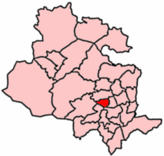
Toller is a ward within the City of Bradford Metropolitan District Council of West Yorkshire, England. The population of the ward as of the 2011 Census was 19,914.

Queensbury is a large village in the metropolitan borough of Bradford, West Yorkshire, England. Perched on a high vantage point above Halifax, Clayton and Thornton and overlooking Bradford itself, Queensbury is one of the highest parishes in England, with fine views beyond the West Yorkshire conurbation to the hills of Brontë Country and the Yorkshire Dales to the north and north west. It had a population of 8,718 in 2001 which increased to 16,273 in the 2011 Census.

Keighley East is a ward within the City of Bradford Metropolitan District Council in the county of West Yorkshire, England. The population had increased to 16,775 at the 2011 Census.

Keighley West is a ward within the City of Bradford Metropolitan District Council in the county of West Yorkshire, England. The population at the 2011 Census was 16,551.

Keighley Central is a ward in City of Bradford Metropolitan District Council in the county of West Yorkshire, England. Its population is 16,276 as per the United Kingdom Census 2001, increasing to 18,255 at the 2011 Census.

Craven is an electoral ward within the City of Bradford Metropolitan District Council, West Yorkshire, England. The population of the ward at the 2011 Census was 16,373.

Wharfedale is a ward in the north east of the City of Bradford Metropolitan District Council in West Yorkshire, England and is situated in Wharfedale, one of the Yorkshire Dales. It consists of the settlements of Burley-in-Wharfedale, Burley Woodhead and Menston along with surrounding moorland. The population of the ward taken at the 2011 Census was 11,836.

Bowling and Barkerend is an electoral ward within the City of Bradford Metropolitan District Council. The population at the 2011 Census was 20,618.

Bradford Moor is an electoral ward within the City of Bradford Metropolitan District Council. The population of the ward at the 2011 Census was 21,210. The ward includes the areas of Laisterdyke and Thornbury.

Great Horton is a ward of the City of Bradford, West Yorkshire, England, with a population of 17,683 at the 2011 Census.

Idle and Thackley is a ward within the City of Bradford Metropolitan District Council in the county of West Yorkshire, England, named after the villages of Idle and Thackley around which it is drawn. The population of 14,541 according to the 2001 UK census had increased at the 2011 Census to 16,135.

Royds is a ward within the City of Bradford Metropolitan District Council in the county of West Yorkshire, England. The population at the 2011 Census was 17,360.

Wibsey is a ward within the City of Bradford Metropolitan District Council, West Yorkshire, England. The population had increased to 14,671 at the 2011 Census. Wibsey is named after Wibsey village which makes up the main part of the ward. As well as the area of Wibsey, the ward includes the area of Bankfoot to the east and much of the area of Odsal. It is located on a ridge which runs from the city centre, up to Queensbury, which has been credited as the highest market town in England.

Wyke is a ward within the City of Bradford Metropolitan District Council in the county of West Yorkshire, England, named after the village of Wyke. The population taken at the 2011 Census was 14,958.

Thornton and Allerton is a ward within the City of Bradford Metropolitan District Council in the county of West Yorkshire, England, named after the villages of Thornton and Allerton around which it is drawn.

Windhill and Wrose is a ward within the City of Bradford Metropolitan District Council in the county of West Yorkshire, England, named after the districts of Windhill and Wrose around which it is drawn.

City of Bradford Metropolitan District Council is the local authority of the City of Bradford in West Yorkshire, England. It is a metropolitan district council, one of five in West Yorkshire and one of 36 in the metropolitan counties of England, and provides the majority of local government services in Bradford. Since 1 April 2014 it has been a constituent council of the West Yorkshire Combined Authority.
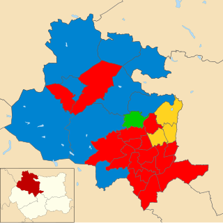
The 2015 City of Bradford Metropolitan District Council election took place on 7 May 2015. This was on the same day as other local elections and a general election. One councillor was elected in each ward for a four-year term so the councillors elected in 2015 last stood for election in 2011. Each ward is represented by three councillors, the election of which is staggered, so only one third of the councillors were elected in this election. Labour retained overall control of the council.

