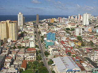
Havana is the capital and largest city of Cuba. The heart of the La Habana Province, Havana is the country's main port and commercial center. It is the most populous city, the largest by area, and the second largest metropolitan area in the Caribbean region. The population in 2002 was 2,137,847 inhabitants, and its area is 728.26 km2 (281.18 sq mi) for the capital city side and 8,475.57 km2 for the metropolitan zone.

Castillo San Felipe del Morro, most commonly known as El Morro(The Promontory), is a large fortress and citadel in the historic district of Old San Juan, Puerto Rico. Commissioned by King Charles I of Spain in 1539, it was first built as a fortified tower in honor of King Philip II, who oversaw its expansion into a hornwork fort by 1595. Over the next 200 years, especially in the reign of King Charles III, El Morro continued to be developed to reach its current form in 1787. Rising 140 ft from the Atlantic shoreline with 18 to 25 ft thick walls, it stands on a steep, rocky headland promontory on San Juan Islet guarding the entry to San Juan Bay, the harbor of Old San Juan. El Morro, alongside La Fortaleza, San Cristóbal, El Cañuelo, and other forts part of the Walls of Old San Juan, protected strategically and militarily important Puerto Rico, or La Llave de las Indias , from invasion by competing world powers during the Age of Sail. It was designated a World Heritage Site by UNESCO in 1983.

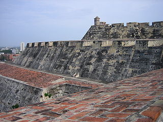
Castillo San Cristóbal is a fortress in San Juan, Puerto Rico. It was built by the Spanish to protect against land-based attacks on the historic city of Old San Juan. It is part of San Juan National Historic Site.

Old San Juan is a historic district located at the "northwest triangle" of the islet of San Juan in San Juan. Its area roughly correlates to the Ballajá, Catedral, Marina, Mercado, San Cristóbal, and San Francisco sub-barrios (sub-districts) of barrio San Juan Antiguo in the municipality of San Juan, Puerto Rico. Old San Juan is the oldest settlement within Puerto Rico and the historic colonial district of the city of San Juan. This historic district is a National Historic Landmark District named Zona Histórica de San Juan and is listed on the United States National Register of Historic Places as the Old San Juan Historic District. Several historical buildings and structures, particularly La Fortaleza, the city walls, and El Morro and San Cristóbal castles, have been inscribed in the UNESCO World Heritage Site list since 1983. Historically the mixed-use commercial and residential real estate in the main streets of Calle Cristo and Calle Fortaleza from Calle Tanca to the Governor’s Mansion is the most valuable in the area and it has kept its value and increased steadily through several years despite the past economic turmoils.

The Castillo de los Tres Reyes del Morro(English: Castle of the Three Kings of Morro), also known as Castillo del Morro(Morro Castle), is a fortress guarding the entrance to the Havana harbor. The design is by the Italian engineer Battista Antonelli (1547–1616). Originally under the control of Spain, the fortress was captured by the British in 1762, returned to Spain under the Treaty of Paris (1763) a year later. The Morro Castle was the main defense in the Havana harbor until La Cabaña was completed in 1774.

Vedado is a central business district and urban neighborhood in the city of Havana, Cuba. Bordered on the east by Calzada de Infanta and Central Havana, and on the west by the Alemendares River and Miramar / Playa district, Vedado is a more modern part of the city than the areas to the east, developed in the first half of the 20th century, during the Republic period. In 2016 it was described by one commentator as the city's "most affluent" section. The main street running east to west is Calle 23, also known as "La Rampa". The northern edge of the district is the waterfront seawall known as the Malecón, a famous and popular place for social gatherings in the city. The area popularly referred to as 'Vedado' consists of the wards of Vedado, Rampa, Vedado-Malecón and Carmelo, all in the municipality of Plaza de la Revolución.
Cuban infrastructure is significant and includes: massive Spanish fortifications built in principal ports.
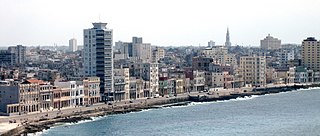
The Malecón is a broad esplanade, roadway, and seawall that stretches for 8 km along the coast in Havana, Cuba, from the mouth of Havana Harbor in Old Havana, along the north side of the Centro Habana neighborhood and the Vedado neighborhood, ending at the mouth of the Almendares.

The Castillo de la Real Fuerza is a bastion fort on the western side of the harbour in Havana, Cuba, set back from the entrance, and bordering the Plaza de Armas. Originally built to defend against attack by pirates, it suffered from a poor location; it was too far inside the bay. The fort is considered to be the oldest stone fort in the Americas, and was listed in 1982 as part of the UNESCO World Heritage Site of "Old Havana and its Fortifications".

Castillo San Salvador de la Punta is a fortress at the entrance to the bay in Havana, Cuba.

The Palacio de los Capitanes Generales is the former official residence of the Spanish Empire's governors of Havana, Cuba, and in the Post-Colonial Period was for many time the City Hall. Located on the eastern side of the Plaza de Armas in Old Havana it is home to the Museum of the City of Havana. It houses exhibitions of art and historical artefacts and many of the rooms are preserved with their original Colonial decoration.
Battista Antonelli (1547–1616) was a military engineer from a prestigious Italian family of military engineers in the service of the Habsburg monarchs of Austria and Spain. He is credited with designing fortresses in Spanish colonial cities in the Caribbean, including Cartagena de Indias in Colombia, Havana in Cuba, and San Juan Bautista in Puerto Rico.

Havana was founded in the sixteenth century displacing Santiago de Cuba as the island's most important city when it became a major port for Atlantic shipping, particularly the Spanish treasure fleet.

Paseo del Prado is a street and promenade in Havana, Cuba, near the location of the old city wall, and the division between Centro Habana and Old Havana. Technically, the Paseo del Prado includes the entire length of Paseo Martí approximately from the Malecon to Calle Máximo Gómez, the Fuente de la India fountain. The promenade has had several names; it was renamed Paseo de Martí in 1898 with the island's independence from Spain. Despite the historic references, the people of Havana simply call it "El Prado".

The Castillo del Príncipe is a military fort located in the Loma de Aróstegui, in Havana, Cuba. In 1982, the fort was inscribed on the UNESCO World Heritage List, along with other historic sites in Old Havana, because of the city's importance in the European conquest of the New World, its fortifications, and its unique architecture.

The Torreón de la Chorrera, or to give it its full name, Fuerte de Santa Dorotea de la Luna de la Chorrera, was completed in May 1646. The tower stands on a coral islet only a few metres from the shore and not much larger than the tower itself. The tower's purpose was to impede the entry of enemy ships into the mouth of the Almendares River. The British damaged and captured the tower when they took the city in 1762, after which the tower was rebuilt in its present form. Today, the tower contains a restaurant. In 1982, the Torreón was inscribed on the UNESCO World Heritage List, along with other historic sites in Old Havana, because of the city's importance in the European conquest of the New World, its fortifications, and its unique architecture.
The following is a timeline of the history of Havana, Cuba.

The Castillo de Santo Domingo de Atarés is a small hexagonal hilltop fort in Havana built in 1767. Work commenced in 1763, around the same time as initial work on Castillo del Príncipe. It is located on La loma de Soto above the harbour. In 1982, the fort was inscribed on the UNESCO World Heritage List, along with other historic sites in Old Havana, because of the city's importance in the European conquest of the New World, its fortifications, and its unique architecture.

Barrio de San Lázaro is one of the first neighbourhoods in Havana, Cuba. It initially occupied the area bounded by Calle Infanta to the west, Calle Zanja to the south, Calle Belascoáin to the east, and the Gulf of Mexico to the north, forming the western edge of Centro Habana. According to the 1855 Ordenanzas Municipales of the city of Havana, Barrio San Lázaro was the Tercer Distrito and was Barrio No. 8.

Arcabuco was the name of a footpath starting in Old Havana, in the vicinity of the church of Loma del Ángel, and ran in a westerly direction to an inlet cove of approximately 93 metres (305 ft) wide and 5.5 metres (18 ft) in depth. When Juan Guillén a Spanish soldier installed a carpentry shop to build small boats close to the cove the site became known as “La Caleta de Juan Guillén”, the road was known as “the caleta”. Eventually the Hospital de San Lázaro, the Espada Cemetery, the San Dionisio mental asylum, and La Casa de Beneficencia were developed in close proximity to the Caleta de San Lazaro.