
Lake Itasca is a small glacial lake, approximately 1.8 square miles in area. It is located in Itasca State Park, in south-eastern Clearwater County, in the Headwaters area of north-central Minnesota, and is notable for being the headwater of the Mississippi River. It has an average depth of 20 to 35 feet and is 1,475 feet (450 m) above sea level.

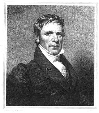
Henry Rowe Schoolcraft was an American geographer, geologist, and ethnologist, noted for his early studies of Native American cultures, as well as for his 1832 expedition to the source of the Mississippi River. He is also noted for his major six-volume study of Native Americans commissioned by Congress and published in the 1850s.

Cass Lake is a lake in north central Minnesota in the United States. It is approximately 10 mi (16 km) long and 7 mi (11 km) wide, located in Cass and Beltrami counties, within the Chippewa National Forest and the Leech Lake Indian Reservation, adjacent to its namesake city of Cass Lake. It is the 11th largest lake in Minnesota, and the 8th largest lake lying entirely within the borders of the state.

Leech Lake is a lake located in north central Minnesota, United States. It is southeast of Bemidji, located mainly within the Leech Lake Indian Reservation, and completely within the Chippewa National Forest. It is used as a reservoir. The lake is the third largest in Minnesota, covering 102,947.83 acres (416.6151 km2) with 195 miles (314 km) of shoreline and has a maximum depth of 156 feet (48 m).

The Rum River is a slow, meandering stream that connects Minnesota's Mille Lacs Lake with the Mississippi River. It runs for 151 miles (243 km) through the communities of Onamia, Milaca, Princeton, Cambridge, Isanti, and St. Francis before ending at the city of Anoka, roughly 20 miles northwest of Minneapolis. It is one of the six protected Wild and Scenic rivers in Minnesota.
Sandy Lake Band of Mississippi Chippewa are a historical Ojibwa tribe located in the upper Mississippi River basin, on and around Big Sandy Lake in what today is in Aitkin County, Minnesota. Though politically folded into the Mille Lacs Band of Ojibwe, thus no longer independently federally recognized, for decades, Sandy Lake Band members have been leading efforts to restore their independent Federal recognition.

The White Earth Band of the Minnesota Chippewa Tribe, also called the White Earth Nation, is a federally recognized Native American band located in northwestern Minnesota. The band's land base is the White Earth Indian Reservation.

The Leech Lake Reservation is an Indian reservation located in the north-central Minnesota counties of Cass, Itasca, Beltrami, and Hubbard. The reservation forms the land base for the federally recognized Leech Lake Band of Ojibwe, one of six bands comprising the Minnesota Chippewa Tribe, organized in 1934. The Leech Lake Reservation has the second highest population of any reservation in Minnesota with White Earth Nation being the largest Minnesota Ojibwe tribe, Leech Lake Nation has a resident population of 11,388 indicated by the 2020 census.

The Leech Lake Band of Ojibwe, also known as the Leech Lake Band of Chippewa Indians or the Leech Lake Band of Minnesota Chippewa Tribe is an Ojibwe band located in Minnesota and one of six making up the Minnesota Chippewa Tribe. The band had 9,426 enrolled tribal members as of March 2014. The band's land base is the Leech Lake Indian Reservation, which includes eleven communities aggregated into three districts, as defined in the tribal constitution,

The Lac Courte Oreilles Tribe is one of six federally recognized bands of Ojibwe people located in present-day Wisconsin. It had 7,275 enrolled members as of 2010. The band is based at the Lac Courte Oreilles Indian Reservation in northwestern Wisconsin, which surrounds Lac Courte Oreilles. The main reservation's land is in west-central Sawyer County, but two small plots of off-reservation trust land are located in Rusk, Burnett, and Washburn counties. The reservation was established in 1854 by the second Treaty of La Pointe.
Mississippi River Band of Chippewa Indians or simply the Mississippi Chippewa, are a historical Ojibwa Band inhabiting the headwaters of the Mississippi River and its tributaries in present-day Minnesota.
John Tanner, known also by his Ojibwe name Shaw-shaw-wa-ne-ba-se, was captured by Odawa Indians as a child after his family had homesteaded on the Ohio River in present-day Kentucky. He grew up among the Odawa and Ojibwe nations, becoming fully acculturated and learning the Saulteaux language. He married an Indian woman, served as a guide for European fur traders, and worked as an interpreter. His story of life with the American Indians was published in 1830. Titled A Narrative of the Captivity and Adventures of John Tanner, it was a popular success and remains an important historical record.
Pillager Band of Chippewa Indians are a historical band of Chippewa (Ojibwe) who settled at the headwaters of the Mississippi River in present-day Minnesota. Their name "Pillagers" is a translation of Makandwewininiwag, which literally means "Pillaging Men". The French called them Pilleurs, also a translation of their name. The French and Americans adopted their autonym for their military activities as the advance guard of the Ojibwe in the invasion of the Dakota country.

The Namekagon River is a tributary of the St. Croix River. It is 101 miles (163 km) long and is located in northwestern Wisconsin in the United States. Its course is protected as part of the St. Croix National Scenic Riverway.

Chief Buffalo was a major Ojibwa leader, born at La Pointe in Lake Superior's Apostle Islands, in what is now northern Wisconsin, USA.
Lac Courte Oreilles is a large freshwater lake located in northwest Wisconsin in Sawyer County in townships 39 and 40 north, ranges 8 and 9 west. It is irregular in shape, having numerous peninsulas and bays, and is approximately six miles long in a southwest to northeast direction and with a maximum width of about two miles (3 km). Lac Courte Oreilles is 5,039 acres (20.39 km2) in size with a maximum depth of 90 feet (27 m) and a shoreline of 25.4 miles (40.9 km). The lake has a small inlet stream that enters on the northeast shore of the lake and flows from Grindstone Lake, a short distance away to the north. An outlet on the southeast shore of the lake leads through a very short passage to Little Lac Courte Oreilles, then via the Couderay River to the Chippewa River, and ultimately to the Mississippi River at Lake Pepin.

The Battle of Sugar Point, or the Battle of Leech Lake, was fought on October 5, 1898 between the 3rd U.S. Infantry and members of the Pillager Band of Chippewa Indians in a failed attempt to apprehend Pillager Ojibwe Bugonaygeshig, as the result of a dispute with Indian Service officials on the Leech Lake Reservation in Cass County, Minnesota.
Windigo Lake is a freshwater lake located in north central Wisconsin in the Town of Bass Lake, Sawyer County, United States, in township 40 north, range 9 west. The lake is irregular in shape, with numerous peninsulas and bays, and is approximately one mile in diameter. Windigo Lake is 529.6 acres (2.143 km2) in size with a maximum depth of 51 feet (16 m) and a shoreline of 9 miles (14 km). The lake does not have an obvious inflow or outflow stream and is classified as a seepage lake, i.e., a lake without an inlet or an outlet.
Lake Plantagenet is a lake in the U.S. state of Minnesota.
