Parkside, South Australia

Last updated

Parkside
Adelaide,  South Australia
Straphaelsps.jpg
St Raphael's Catholic School
Population4,791 (2016 census) [1]
 • Density2,939/km2 (7,613/sq mi)
Established1849 [2]
Postcode(s) 5063 [3]
Area1.63 km2 (0.6 sq mi)
Location2.4 km (1 mi) S of Adelaide city centre [3]
LGA(s) City of Unley
State electorate(s) Unley (2011) [4]
Federal Division(s) Adelaide (2011) [5]
Suburbs around Parkside:
Adelaide
Park Lands
Adelaide
Park Lands
Eastwood
Unley Parkside Fullarton
Malvern Fullarton Fullarton

Parkside is an inner southern suburb of Adelaide, South Australia. It is located in the City of Unley.

Contents

History

The suburb was once home to the mental health campus of the Royal Adelaide Hospital. Known as 'The Parkside Asylum', it was the primary mental health facility in the state, and occupied approximately one-third of the suburb's area.[ verification needed ]

Parkside Post Office opened on 10 December 1859 and was renamed Eastwood in 1967. [6]

Geography

Parkside lies on the southern boundary of the southern park lands. It is bounded, among others, by Glen Osmond, Greenhill, Unley and Fullarton roads. [7]

Demographics

The 2006 Census by the Australian Bureau of Statistics counted 4,634 persons in Parkside on census night. Of these, 46.9% were male and 53.1% were female. [8]

The majority of residents (72.3%) are of Australian birth, with other common census responses being England (5.2%), Greece (2.9%) and Italy (2.8%). [8]

The age distribution of Parkside residents is comparable to that of the greater Australian population. 71.7% of residents were over 25 years in 2006, compared to the Australian average of 66.5%; and 28.3% were younger than 25 years, compared to the Australian average of 33.5%. [8]

Community

Parkside Primary School Parksideps.jpg
Parkside Primary School

The local newspaper is the Eastern Courier Messenger. Other regional and national newspapers such as The Advertiser and The Australian are also available. [9]

Schools

Parkside Primary School is located on Robsart Street. St Raphael's School is on Glen Osmond Road. [10]

Facilities and attractions

Shopping and dining

The suburb is within walking distance of the Unley Road shopping and dining precinct. [7]

Parks

One of the largest parks in Parkside is Howard Florey Reserve, on the corner of Campbell Road and Fullarton Road. Henry Codd Reserve lies between Maud Street and Fuller Street and connects via a walking trail to the Leicester Street playground. There is also Mcleay Park, lying between George Street and Jaffrey Street. Most of these parks are fenced in, making them suitable for small children. All have their own playgrounds. [7]

Entertainment

Slingsby Theatre Company, an internationally touring theatrical company, has its home on Glen Osmond Road. The company seeks to "...lovingly craft original, beautiful, complex, life-affirming, heartfelt, richly rewarding, emotive and bold theatre for adults and young people...". [11]

Transportation

Roads

The suburb is serviced by several main roads. Unley and Fullarton Roads connect the suburb to the Adelaide city centre. Glen Osmond Road passes beside Parkside, linking the inner southeast of metropolitan Adelaide to the South Eastern Freeway. [7]

Public transport

Public transport in Parkside is serviced by routes 171 and 172, run by the Adelaide Metro. [12]

The Glenelg tram line is also very close to Parkside and there was once another tram line running south from the city.

See also

Related Research Articles

Glenunga is an inner southeastern suburb of Adelaide, the capital of South Australia. It is located in the City of Burnside, five kilometres southeast of the Adelaide city centre. The name Glenunga is a composite of Aboriginal and Scottish words, "unga" meaning near and "glen" from the nearby Glen Osmond Bounded on the north by Windsor Road, the east by Portrush Road, the south-west by Glen Osmond Road and the west by Conyngham Street, the leafy suburb forms a rough triangular layout.

Unley is an inner-southern suburb of Adelaide, South Australia, within the City of Unley. The suburb is the home of the Sturt Football Club in the South Australian National Football League (SANFL). Unley neighbours Adelaide Park Lands, Fullarton, Hyde Park, Malvern, Parkside and Wayville.

Eastwood, South Australia Suburb of Adelaide, South Australia

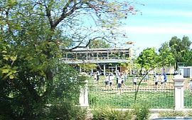
Eastwood is a small triangular inner-southern suburb of Adelaide, South Australia in the City of Burnside.

Frewville, South Australia Suburb of Adelaide, South Australia

Frewville is a small suburb in the South Australian city of Adelaide. It is three kilometres south-east of Adelaide's central business district (CBD).

Black Forest, South Australia Suburb of Adelaide, South Australia

Black Forest is an inner southern suburb of Adelaide, South Australia. It is located in the City of Unley, bounded by the Glenelg Tramline (northwest), the Seaford railway line (southeast), South Road (west) and East Avenue (east).

Unley Park, South Australia Suburb of Adelaide, South Australia

Unley Park is a southern suburb of Adelaide in the City of Unley. Its postcode is 5061.

Broadview, South Australia Suburb of Adelaide, South Australia

Broadview is a suburb of Adelaide, South Australia. It is located in the City of Port Adelaide Enfield and the City of Prospect.

Thorngate, South Australia Suburb of Adelaide, South Australia

Thorngate is an inner northern suburb of Adelaide, South Australia. It is located in the City of Prospect.

Electoral district of Unley

Unley is a single-member electoral district for the South Australian House of Assembly. Named after the suburb of the same name, it is the state's smallest electorate by area at just 14.1 km2 (5.4 sq mi). It is a suburban electorate in Adelaide's inner south, taking in the suburbs of Eastwood, Frewville, Fullarton, Glenside, Glenunga, Goodwood, Highgate, Hyde Park, Kings Park, Malvern, Myrtle Bank, Parkside, Unley, Unley Park and Wayville, as well as parts of Glen Osmond and Millswood.

Cross Road, Adelaide

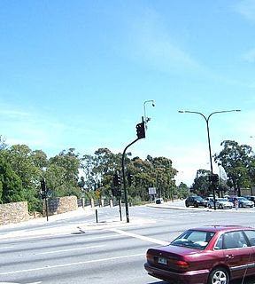
Cross Road is a major arterial road that travels east–west through the inner southern suburbs of the Australian city of Adelaide. Its western terminus is at Anzac Highway, travelling east and ending at Glen Osmond and the Adelaide Hills, joining the junction of Glen Osmond Road, Portrush Road, and South Eastern Freeway.

Glen Osmond Road, Adelaide

Glen Osmond Road is a major section of the Princes Highway and state Highway 1 in the city of Adelaide, South Australia. Connecting the Adelaide city centre with the Adelaide Hills via the South Eastern Freeway; Glen Osmond Road carries half of Adelaide's freight traffic and is the major commuter route from the southern Adelaide Hills. It has intersections at Greenhill Road, Fullarton Road, Cross Road and Portrush Road.

Fulham, South Australia Suburb of Adelaide, South Australia

Fulham is a western suburb of Adelaide, South Australia. It is located in the City of West Torrens.

Hilton, South Australia Suburb of Adelaide, South Australia

Hilton, on Kaurna land, is an inner western suburb of Adelaide, South Australia. It is located in the City of West Torrens, for which it is the council seat.

Ridleyton, South Australia Suburb of Adelaide, South Australia

Ridleyton is an inner northern suburb of Adelaide, South Australia. It is located in the City of Charles Sturt.

Renown Park, South Australia Suburb of Adelaide, South Australia

Renown Park is an inner northern suburb of Adelaide, South Australia. It is located in the City of Charles Sturt.

Fulham Gardens is a western suburb of Adelaide, South Australia in the City of Charles Sturt.

Kidman Park is a western suburb of Adelaide, South Australia. It is located in the City of Charles Sturt.

Kilkenny, South Australia Suburb of Adelaide, South Australia

Kilkenny is an inner north-western suburb of Adelaide, South Australia. It is located in the City of Charles Sturt. It is named after Kilkenny, Ireland.

Findon is a western suburb of Adelaide, South Australia. It is located in the City of Charles Sturt.

Beverley, South Australia Suburb of Adelaide, South Australia

Beverley is a western suburb of Adelaide, South Australia. It is located in the City of Charles Sturt.

References

  1. Australian Bureau of Statistics (27 June 2017). "Parkside (State Suburb)". 2016 Census QuickStats. Retrieved 30 July 2019. OOjs UI icon edit-ltr-progressive.svg
  2. "How Unley Developed". City of Unley official website. City of Unley. Archived from the original on 27 December 2008. Retrieved 17 April 2011.
  3. 1 2 "Parkside, South Australia (Adelaide)". Postcodes-Australia. Postcodes-Australia.com. Retrieved 17 April 2011.
  4. "Electoral Districts - Electoral District for the 2010 Election". Electoral Commission SA. Archived from the original on 22 August 2011. Retrieved 17 April 2011.
  5. "Find my electorate". Australian Electoral Commission. 15 April 2011. Archived from the original on 30 April 2011. Retrieved 17 April 2011.
  6. Premier Postal History. "Post Office List". Premier Postal Auctions. Retrieved 26 May 2011.
  7. 1 2 3 4 Adelaide and surrounds street directory (47th ed.). UBD. 2009. ISBN   978-0-7319-2336-6.
  8. 1 2 3 Australian Bureau of Statistics (25 October 2007). "Parkside (State Suburb)". 2006 Census QuickStats. Retrieved 17 April 2011.
  9. "South Australian Newspapers". Newspapers.com.au. Australia G'day. Archived from the original on 29 April 2011. Retrieved 17 April 2011.
  10. "Australian Schools Directory". Australian Schools Directory. Retrieved 17 April 2011.
  11. "About". Slingsby Theatre Company. Retrieved 22 June 2019.
  12. "Public Transport in Adelaide". Adelaide Metro official website. Dept. for Transport, Energy and Infrastructure, Public Transport Division. 12 January 2011. Archived from the original on 26 April 2011. Retrieved 17 April 2011.

Coordinates: 34°56′38″S138°36′47″E / 34.944°S 138.613°E / -34.944; 138.613