
Tanah Abang is a district of Central Jakarta, Indonesia. The district hosts the biggest textile market in Southeast Asia, Tanah Abang Market. Tanah Abang District is also the location of Bung Karno Stadium and the western half of the Sudirman Central Business District.
Gambir is a district of Central Jakarta, Indonesia. It is characterized by many historic buildings from the colonial era. Gambir District is the location of many political and administrative center of Jakarta and Indonesia. The Merdeka Palace, the National Museum, the headquarters of the Indonesian Scout Movement and the Merdeka Square are located in Gambir.

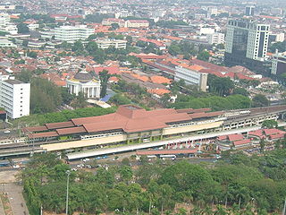
Gambir Station is a major railway station in Gambir, Gambir, Central Jakarta, Jakarta, Indonesia. It is located on the eastern side of Merdeka Square. It was built during the Dutch East Indian era and renovated in the 1990s.

Pasar Minggu is a district of South Jakarta, Jakarta, Indonesia. The area is known for its traditional Sunday market, famous for the fruit market. Historically, Pasar Minggu is a fruit cultivation area developed by the Dutch government during the colonial period. The central point of the cultivation area is the traditional market of Pasar Minggu, located in what is now Pasar Minggu Kelurahan. Teak forest could also be found in Pasar Minggu district, notably around Jati Padang Kelurahan. Most of these areas has been converted into residential area as Jakarta grow southward.

Cempaka Putih is a subdistrict of Central Jakarta, Indonesia. Cempaka Putih is roughly bounded by Jenderal Ahmad Yani bypass highway to the east, Pramuka boulevard to the south, Letjend Suprapto boulevard to the north, and a railway line to the west. The name "Cempaka Putih" derived from flowering plant white champaca.

Sawah Besar is a subdistrict (kecamatan) of Central Jakarta, Indonesia. The neighborhoods within the subdistrict are among the most historic subdistrict in Jakarta, containing the 1820-established Pasar Baru, the colonial administrative center of Weltevreden, as well as the old course of the Ciliwung. Many colonial landmarks are located in the subdistrict, e.g. the Lapangan Banteng, the A.A. Maramis Building, and the Jakarta Cathedral.

Senen is a commercial center in Jakarta, Indonesia. The area was developed in the 18th-century as Pasar Senen at the time when governor Daendels established the bovenstad as the new center of government of Batavia. The area is one of the oldest commercial center in Jakarta. This historic commercial center of Senen is located in what is now the Administrative Village of Senen, in the northern part of the Senen Subdistrict. This article covers both Senen as the historic commercial center and as a Subdistrict of Central Jakarta.

Ciracas is a district (kecamatan) of East Jakarta, one of the five administrative cities which form Jakarta, Indonesia. Ciracas is the southernmost district of Jakarta. The area of Cibubur Scout's camping ground complex is located partly within the Ciracas District, although the main camping ground area is located in Cipayung District. The boundaries of Ciracas District are: Cipinang River to the west, Cipinang River - Jambore Road to the south, Jagorawi Tollroad to the east, and Kelapa Dua Wetan Road to the north.

Jatinegara is one of the districts (Kecamatan) of East Jakarta, Indonesia. The name also refers to the larger, historic area of the colonial town of Meester Cornelis. Established in the 17th century, Jatinegara is one of the oldest areas in Jakarta, and contains a number of buildings from the colonial period.
Makasar is a district (kecamatan) of East Jakarta, Indonesia. It had an area of 21.85 km² and population of 185,830 at the 2010 Census; the latest official estimate is 204,595.

Kebayoran Baru is a district of South Jakarta, Indonesia. The name of the district was derived from an area which was developed in the post-war period as a new suburb town of Jakarta, Kebayoran Baru. Kebayoran Baru was the last residential area to be developed by the Dutch colonial administration. The urban planning was laid in a concept of the Garden city movement, consisting of a well-planned residential area, a shopping center, and a business district, supported with civic facilities e.g. schools, places of worship, hospitals, and parks. Many important governmental institutions are located in Kebayoran Baru, such as the Indonesia Stock Exchange building, the ASEAN Secretariat building, the Criminal Investigation Agency of the National Police, and the City Hall of South Jakarta. Sudirman Central Business District is also located in Kebayoran Baru sub-district.
Betawi Malay, also known as Jakartan Malay or Batavian Malay, is the spoken language of the Betawi people in Jakarta, Indonesia. It is the native language of perhaps 5 million people; a precise number is difficult to determine due to the vague use of the name.
Kampung Baru may refer to several places:

Pasar Baru is an administrative village in the Sawah Besar subdistrict (kecamatan) in Central Jakarta of Indonesia. It has postal code of 10710.
Indraprasta PGRI University is an Indonesian university founded in 1982. It offers open degree programs. The campus is in Tanjung Barat, South Jakarta and Pasar Rebo, East Jakarta. Faculties include education and social sciences, engineering, mathematics and natural science and language and arts.

Mangga Dua is a shopping district at Pademangan subdistrict of North Jakarta, in Indonesia. The area is bordered by Jalan Gajah Mada in the west and Jalan Gunung Sahari in the east, while in the middle is Jalan Pangeran Jayakarta and Jalan Mangga Dua Raya. Mangga Dua is part of Jakarta's long history starting from Sunda Kelapa port and Glodok, which is biggest China town in Indonesia. The area is one of the 12 coastal tourism spots to attract foreign tourists by Dinas Pariwisata dan Kebudayaan. Mangga Dua and contiguous of Glodok are one of the biggest shopping area in southeast Asia.
Kemang is a neighborhood in southern part of Jakarta, Indonesia. The area is located mostly in Bangka subdistrict of Mampang Prapatan and partly within Pejaten subdistrict of Pasar Minggu. The main area of Kemang is marked by the roads of Kemang Raya, Prapanca, and Bangka Streets.

BNI City station is a station for the Soekarno-Hatta Airport Rail Link service. Bank Negara Indonesia (BNI) holds the naming rights for the station, which was known as Sudirman Baru station during construction period. The station is located in Central Jakarta, on the north bank of West Flood Canal, about a hundred meters from Sudirman Commuter Rail station. The station is part of Dukuh Atas TOD.
Muara Angke is a fishing port located at Kapuk Muara, Penjaringan along the north coast of Jakarta, Indonesia. The port is integrated with fishermen's housing and a fishing port management office owned by the DKI Jakarta government. It has modern fish market with supporting facilities for landing and auction of fishes. The port is located at the downstream of Angke River, where it meets Java Sea. Muara Angke Wildlife Reserve is also located in this area, adjacent to Muara Karang.