
Bekasi is a city in West Java, Indonesia, located on the eastern border of Jakarta. It serves as a commuter city within the Jakarta metropolitan area. According to the 2020 Census by Statistics Indonesia (BPS), Bekasi had 2,543,676 inhabitants. The official estimate for mid 2023 was 2,627,207 - comprising 1,320,682 males and 1,306,525 females. It lies within the largest metropolitan area in Indonesia (Jabodetabek). The city is bordered by Bekasi Regency to the north and the east, Bogor Regency and Depok City to the south, and the city of East Jakarta to the west.
East Jakarta is the largest of the five administrative cities which form the Special Capital Region of Jakarta, Indonesia. It had a population of 2,693,896 at the 2010 Census and 3,037,139 at the 2020 Census; the official estimate as at mid 2022 was 3,083,883, making it the most populous of the five administrative cities within Jakarta. East Jakarta is not self-governed and does not have a city council, hence it is not classified as a proper municipality.
Jatinegara is one of the districts of the administrative city of East Jakarta, Indonesia. The name also refers to the larger, historic area of the colonial town of Meester Cornelis. Established in the 17th century, Jatinegara is one of the oldest areas in Jakarta, and contains a number of buildings from the colonial period.
Pasar Rebo is a district (kecamatan) of East Jakarta, Indonesia. The boundaries of Pasar Rebo District are the Ciliwung to the west and north; and Bogor Raya Road and Cipinang River to the east. The city of Depok is located to the south of Pasar Rebo District.
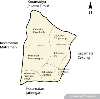
Pulo Gadung is a district (kecamatan) of East Jakarta, Indonesia.
Blitar is a landlocked city in East Java, Indonesia, about 73 km from Malang and 167 km from Surabaya. The area lies within longitude 111° 40' – 112° 09' East and its latitude is 8° 06' South. The city of Blitar lies at an altitude on average 167 metres above sea level, and is an enclave within Blitar Regency which surrounds the city on all sides. It covers an area of 32.57 km2, and had a population of 131,968 at the 2010 Census and 149,149 at the 2020 Census; the official estimate as at mid 2023 was 159,781.

Karawang Regency is a regency (kabupaten) of West Java, Indonesia. The town of Karawang is its administrative centre. The regency covers an area of 1,911.09 km2 and had a population of 2,127,791 people at the 2010 Census, which grew to 2,361,019 at the 2020 Census. The official estimate for mid-2023 was 2,526,002 - comprising 1,277,610 males and 1,248,392 females. The regency borders Bekasi and Bogor Regencies in the west, the Java Sea in the north, Subang Regency in the east, Purwakarta Regency in the southeast, and Cianjur Regency in the south. The regency lies on the eastern outskirts of Metropolitan Jakarta, just outside the Jabodetabek region, and is the site of considerable industrial activity.

Cilincing is a historic neighborhood of the coast of Jakarta, Indonesia. It is sandwiched between the Port of Tanjung Priok to the west and River Titram to the east. Cilincing has been for some decades one of the districts of North Jakarta which in turn encompasses as far as Marunda and some non-coastal hinterland.

Kelapa Gading or also known as KG or Gading, is a district of the administrative city of North Jakarta, Indonesia. The district is known to the local population as a city within a city, due to the integrated residential-commercial planning, and the supporting facilities.
Cikampek is a subdistrict of Karawang Regency, West Java, Indonesia and is divided into 10 administrative villages (kelurahan). The distance from Cikampek to Karawang city is 21 miles.

Cakung Station (CUK) is a class I railway station in Pulogebang, Cakung, East Jakarta. The station, which is located at an altitude of +18 m, is included in the Jakarta Operational Area I and only serves the KRL Commuterline route. The station has a total of six railway tracks.

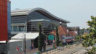
Pulo Gebang Bus Terminal is a type-A bus terminal at Cakung, in East Jakarta, Indonesia, which is arguably the largest of its kind in Southeast Asia. The terminal was opened on 28 December 2016. Designed by Paul Tanjung Tan, this terminal is built to replace the unfeasible Pulo Gadung terminal and providing a comfortable, safe, and well-accessible transportation service. Buses to and from Central & East Java usually use this terminal.

The Jatikramat River is a river in Bekasi, West Java, and the eastern part of the Special Capital Region of Jakarta, Indonesia. The lower portions of the original river have been channelized and directed into the eastern flood canal, "Banjir Kanal Timur", which continues to flow to the Java Sea in the district of Marunda, Cilincing, North Jakarta. The river regularly causes flooding in the city of Bekasi and Jakarta.
Cakung River is a river in the Bekasi, West Java, and the eastern part of the Special Capital Region of Jakarta, Indonesia. The lower portions of the original river have been channelized and directed into the eastern flood canal, "Banjir Kanal Timur", which continues to flow to the Java Sea in the district of Marunda, Cilincing, North Jakarta. The river regularly causes flooding in the cities of Bekasi and Jakarta.
The Buaran River is a river flowing in the Bekasi, West Java, and the eastern part of the Special Capital Region of Jakarta, Indonesia. The lower portions of the original river have been channelized and directed into the eastern flood canal, "Banjir Kanal Timur", which continues to flow to the Java Sea in the district of Marunda, Cilincing, North Jakarta. The river regularly causes flooding in the cities of Bekasi and Jakarta.

The TransJakarta Corridor 11 is a bus rapid transit corridor in East Jakarta, Jakarta, Indonesia, operated by TransJakarta. It connects the Pulo Gebang Bus Terminal in Cakung, with the Kampung Melayu Bus Terminal in Jatinegara. The streets that passed by corridor 11 are Sentra Primer Timur, Dr. Sumarno, Penggilingan, I Gusti Ngurah Rai, Bekasi Barat/Timur, and Jatinegara Barat/Timur streets. Starting from the Stasiun Jatinegara BRT station to the Penggilingan overpass, this corridor is adjacent and integrated with KRL Commuterline on the Cikarang Loop Line route via Jatinegara, Klender, Buaran, and Cakung stations.

Blok M Terminal is a type-B bus terminal located within the commercial and entertainment quarter of Blok M in Kebayoran Baru, Jakarta, Indonesia. It only serves city transport buses that connects several regions in Jakarta and its surrounding cities. The terminal primarily serves Transjakarta's BRT corridors and feeder routes. Perum DAMRI also operates numbers of shuttle bus services from the Soekarno–Hatta International Airport and several gated communities in Greater Jakarta to Blok M terminal. Apart from DAMRI, Mayasari Bakti and Sinar Jaya also operates their bus routes to this terminal.

The TransJakarta Corridor 2 is a bus rapid transit corridor in Jakarta, Indonesia, operated by TransJakarta. It connects the Pulo Gadung Bus Terminal in East Jakarta to the Monumen Nasional BRT Station in Central Jakarta. The streets that passed by corridor 2 are along Perintis Kemerdekaan, Letjen Suprapto, Imam Sapi'i.e., Kwini II, Abdul Rahman Saleh, Pejambon, Medan Merdeka Timur, Perwira, Katedral, Ir. H. Djuanda, Veteran III, and Medan Merdeka Utara streets, and terminates at Monas. For the opposite the direction, the route passes Medan Merdeka Barat, Medan Merdeka Selatan, and Kwitang Raya streets, then continues at Letjen Suprapto street towards Pulo Gadung. This corridor is integrated with the Pasar Senen railway station, which serves the KRL Commuterline and the intercity train services via Pasar Senen BRT station and the Juanda railway station, which serves KRL Commuterline service only via Juanda BRT station.

The TransJakarta Corridor 4 is a bus rapid transit corridor in Jakarta, Indonesia, operated by TransJakarta. It serves the route from the Pulo Gadung Bus Terminal to the Galunggung BRT station in Dukuh Atas TOD. The roads that passed by corridor 4 are Bekasi Raya, Pemuda, Pramuka, Tambak, Sultan Agung, and Galunggung. This route is integrated with the KAI Commuter Cikarang Loop Line at Sudirman Station via Galunggung BRT station, and Manggarai Station which also serves the Bogor Line, Cikarang Loop Line, and the Airport Rail Link routes via the Manggarai BRT station. KRL Commuterline users who want to go to Rawamangun and Pulo Gadung can alight at Sudirman Station and continue their trip from Galunggung, Manggarai, or Pasar Genjing BRT stations. This corridor has been integrated with the Jakarta LRT at the Velodrome LRT station via the Pemuda Rawamangun BRT station.
