Pawling (town), New York

Last updated

Pawling
Pawling, NY, welcome sign.jpg
Town welcome sign along New York State Route 22
Pawling seal.png
Etymology: From Catherine Pauling, wife of Albert Pauling, and eldest daughter of colonial landowner Henry Beekman
Dutchess County New York incorporated areas Pawling highlighted.svg
Location of Pawling, New York
Coordinates: 41°34′N73°36′W / 41.567°N 73.600°W / 41.567; -73.600
CountryUnited States
State New York
Region Hudson Valley
County Dutchess
Founded1788
Government
   Town Supervisor James Schmitt (R)
   Town Council
  • Philip DeRosa (R)
  • Corinne Musella-Pitt (R)
  • Jim McCarthy (R)
  • Coleen Snow (D)
Area
  Total45 sq mi (120 km2)
  Land44.2 sq mi (114 km2)
  Water0.8 sq mi (2 km2)
Elevation
[1]
479 ft (146 m)
Population
 (2020)
  Total8,012
  Density180/sq mi (69/km2)
Time zone UTC-5 (EST)
  Summer (DST) UTC-4 (EDT)
ZIP code
12564
Area code 845
Exchange 855
GNIS feature ID0979347 [1]
Website Welcome to Pawling, NY

Pawling is a town in Dutchess County, New York, United States. Its population was 8,012 at the 2020 census. The town is named after Catherine Pauling, the daughter of Henry Beekman, who held the second largest land patent in the county. The town is in the southeastern part of the county, and contains a village of the same name.

Contents

History

A part of the town was involved in a boundary problem involving New York and Connecticut. A section of the town, located in the "Oblong"—the name was given to the disputed oblong strip of land, two miles in width forming part of the Eastern boundary of the now Dutchess and Putnam Counties—was settled by Nathan Birdsall and his wife Jane Langdon; they were the first pioneer settlers of Quaker Hill, Dutchess, NY. He was a native of Long Island and was born around 1700 to Quaker parents. He was one of the surveyors of the area and picked his home site during the survey.

Nathan purchased his land from the Great Nine Partners Patent, prior to moving his family there, erected a log house and barn, probably around 1720. The next settler was Benjamin Ferris, a Quaker preacher. It was not until 1731, when the one-hundred-year-old dispute as to the boundary between the English in New England and the Dutch in New York was settled, that emigration started in any volume. A number of Friends began coming from Harrisons Purchase, now a part of Rye, in Westchester County, New York. Their Quaker Meeting House is still standing today, and open for visitors.

In the American Revolution colonial commander in chief George Washington established his headquarters at the John Kane House in the town (now the village) for two months in 1778. The town was founded in 1788, but part of the town was used to form the neighboring town of Dover in 1807. The town of Pawling was part of the Beekman Patent, a large land grant to Col. Henry Beekman in 1697.

Geography

According to the United States Census Bureau, the town has a total area of 45.0 square miles (117 km2), of which 44.2 square miles (114 km2) is land and 0.8 square miles (2.1 km2) (1.80%) is water.

The eastern and western section of the towns are high and hilly, with the Great Swamp and Harlem Valley in the middle, where the village of Pawling is located. The highest elevation in town is Observatory Hill, at 1,332 feet (406 m) above sea level; the lowest is 420 feet (130 m), in the Great Swamp, along the southern boundary of the town.

Most of the population of Pawling is concentrated in the valley, traversed by NY 22 (joined by NY 55 south of the village) and Metro-North Railroad's Harlem Line. There are two train stations in town, the Pawling station in the village and the Appalachian Trail station, allowing passengers to hike that trail up into the Pawling Nature Reserve along Hammersby Ridge in the northern section of town.

The southern town line is the border of Putnam County, New York, and the eastern town boundary is the border of Connecticut. To the west lies the town of Beekman, with Dover to the north. It also shares a small border with the town of East Fishkill at the southwestern edge of the town.

Communities, locations and notable places in Pawling

Demographics

Historical population
CensusPop.Note
1820 1,804
1830 1,705−5.5%
1840 1,571−7.9%
1850 1,7209.5%
1860 1,7431.3%
1870 1,7601.0%
1880 2,00614.0%
1890 1,949−2.8%
1900 1,921−1.4%
1910 1,9270.3%
1920 1,9551.5%
1930 2,39122.3%
1940 2,75215.1%
1950 2,8915.1%
1960 3,93836.2%
1970 4,76421.0%
1980 5,79521.6%
1990 5,9472.6%
2000 7,52126.5%
2010 8,46312.5%
2020 8,012−5.3%
U.S. Decennial Census [2]

As of the census [3] of 2000, there were 7,521 people, 2,823 households, and 1,987 families living in the town. The population density was 170.2 inhabitants per square mile (65.7/km2). There were 3,101 housing units at an average density of 70.2 per square mile (27.1/km2). The racial makeup of the town was 94.43% white, 1.46% black or African American, .17% Native American, 1.28% Asian, .04% Pacific Islander, 1.3% from other races, and 1.32% from two or more races. Hispanic or Latino of any race were 4.85% of the population.

There were 2,823 households, out of which 33.8% had children under the age of 18 living with them, 59.6% were married couples living together, 7.4% had a female householder with no husband present, and 29.6% were non-families. 24.7% of all households were made up of individuals, and 10.6% had someone living alone who was 65 years of age or older. The average household size was 2.62 and the average family size was 3.16.

In the town, the population was spread out, with 25.3% under the age of 18, 5.3% from 18 to 24, 29.3% from 25 to 44, 24.9% from 45 to 64, and 15.2% who were 65 years of age or older. The median age was 40 years. For every 100 females, there were 95.8 males. For every 100 females age 18 and over, there were 92.4 males.

The median income for a household in the town was $61,380 and the median income for a family was $70,056. Males had a median income of $47,143 versus $35,063 for females. The per capita income for the town was $30,043. About 1.7% of families and 3.3% of the population were below the poverty line, including 1.2% of those under age 18 and 4.1% of those age 65 or over.

Government

Town hall Pawling, NY, town hall.jpg
Town hall

Since 1878 Pawling has operated under a council-manager form of government.[ citation needed ]

Infrastructure

Fire

The Pawling Fire District is the fire department that covers the Town Of Pawling. By keeping buildings up to code, controlling illegal occupancies, monitoring the safety of living-areas and issuing licenses and permits, the department works to control the potential for dangerous situations. The fire district operates three fire stations spread out all over the town, as their district covers a large area. The department is capable of handling fires, rescues, extrications and natural disasters. The PFD operates a varied fire apparatus fleet, however does not provide Emergency Medical Services. Both BLS and ALS EMS calls are handled by Empress Ambulance (formerly EMStar, which was merged in Sept 2021) who are contracted to provide the town with 24/7 ambulance service. In the event of numerous calls within a short amount of time, ambulances are pulled from neighboring towns including Beekman, Dover and Patterson or, if a backfill unit is available, it will respond from nearby.

Police

Police protection in Pawling is provided by through the Dutchess County Sheriff's office and New York State Police. Sheriff's deputies have a substation located in the middle of the hamlet, near the train station. The MTA police also cover the center of town, as the Metro-North Railroad Harlem Line has a train station in the town.

Medical

Pawling has several free standing doctors' offices and clinics, including Village Medical and The Atrium. Pawling has no hospitals, but within a short distance from town are three medical centers and two hospitals. MidHudson Regional Hospital of Westchester Medical Center and Vassar Brothers Medical Center are located in nearby Poughkeepsie, and Danbury Hospital is located in Danbury, CT. Putnam Hospital Center is located in Carmel in Putnam County and New Milford Hospital in New Milford, CT. There are several urgent care centers located nearby, including in Carmel and LaGrange.

Notable people

Notable places

Related Research Articles

<span class="mw-page-title-main">Dutchess County, New York</span> County in New York, United States

Dutchess County is a county in the U.S. state of New York. As of the 2020 census, the population was 295,911. The county seat is the city of Poughkeepsie. The county was created in 1683, one of New York's first twelve counties, and later organized in 1713. The county is part of the Hudson Valley region of the state.

<span class="mw-page-title-main">Putnam County, New York</span> County in New York, United States

Putnam County is a county located in the U.S. state of New York. As of the 2020 census, the population was 97,668. The county seat is Carmel, located within one of six towns comprising the county. The county is part of the Hudson Valley region of the state.

<span class="mw-page-title-main">Beekman, New York</span> Town in New York, United States

Beekman is a town in Dutchess County, New York, United States. It is part of the Poughkeepsie–Newburgh–Middletown, NY Metropolitan Statistical Area as well as the larger New York–Newark–Bridgeport, NY-NJ-CT-PA Combined Statistical Area. The population was 14,172 at the 2020 census. The town was named after Henry Beekman, a 17th-century land owner.

<span class="mw-page-title-main">Clinton, Dutchess County, New York</span> Town in New York, United States

Clinton is a town in Dutchess County, New York, United States. The population was 4,037 in the 2020 census, down from 4,312 in the 2010 census.

<span class="mw-page-title-main">Dover, New York</span> Town in New York, United States

Dover is a town in Dutchess County, New York, United States. The population was 8,415 at the 2020 census. The town was named after Dover in England, the home town of an early settler.

<span class="mw-page-title-main">East Fishkill, New York</span> Town in New York, United States

East Fishkill is a town on the southern border of Dutchess County, New York, United States. The population was 29,707 at the 2020 census. Until its creation in 1849, the town was the eastern portion of the town of Fishkill.

<span class="mw-page-title-main">LaGrange, New York</span> Town in New York, United States

LaGrange is a town in Dutchess County, New York, United States. The population was 15,975 at the 2020 census. The town was named after the estate of the Marquis de Lafayette.

<span class="mw-page-title-main">North East, New York</span> Town in New York, United States

North East is a town in Dutchess County, New York, United States. The population was 3,031 at the 2020 census. The town is in the northeastern corner of the county. U.S. Route 44 crosses the town.

<span class="mw-page-title-main">Union Vale, New York</span> Town in New York, United States

Union Vale is a town in Dutchess County, New York, United States. The population was 4,558 at the 2020 census.

<span class="mw-page-title-main">Wappinger, New York</span> Town in New York, United States

Wappinger is a town in Dutchess County, New York, United States. The town is located in the Hudson River Valley region, on the eastern bank of the Hudson River. The population was 28,216 at the 2020 census. The name is derived from the Wappinger Native Americans who inhabited the area. Wappinger comprises three-fourths of the incorporated village of Wappingers Falls, several unincorporated hamlets such as Chelsea, Diddell, Hughsonville, Middlebush, Myers Corners, New Hackensack, and Swartwoutville, and a number of neighborhoods.

<span class="mw-page-title-main">Washington, New York</span> Town in Dutchess County, New York, US

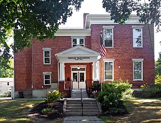
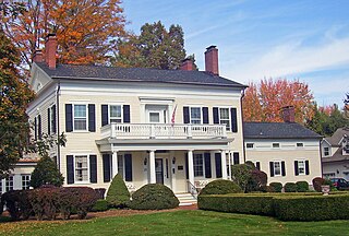
Washington is a town in Dutchess County, New York, United States. The population was 4,522 at the 2020 census. The town is named after George Washington, who passed through the town during the Revolution.

<span class="mw-page-title-main">Carmel, New York</span> Town in New York, United States

Carmel is a town in Putnam County, New York, United States. As of the 2020 United States census, the town had a population of 33,576.

<span class="mw-page-title-main">Kent, New York</span> Town in New York, United States

Town of Kent is a town in Putnam County, New York, United States. The population was 12,900 at the 2020 census. The name is that of an early settler family. The town is in the north-central part of the Putnam County. Many of the lakes are reservoirs for New York City.

<span class="mw-page-title-main">Patterson, New York</span> Town in New York, United States

Patterson is a town in Putnam County, New York, United States. The town is in the northeastern part of the county. Interstate 84 passes through the southwestern section of the town. The population was 11,541 at the 2020 census. The town is named after early farmer Matthew Paterson. The reason Patterson was spelled with two "t"s was due to the looseness with which Paterson spelled his own last name.

<span class="mw-page-title-main">Philipstown, New York</span> Town in New York, United States

Philipstown is a town located in the western part of Putnam County, New York, United States. The population was 9,831 at the 2020 census.

<span class="mw-page-title-main">Southeast, New York</span> Town in New York, United States

Southeast is a town in Putnam County, New York, United States, so named for its location in the southeastern corner of the county. The population was 18,058 at the 2020 census. The town as a whole is informally referred to as Brewster, the town's principal settlement; the latter is also an incorporated village within the town's borders. Interstate 84, Interstate 684, U.S. Route 202, US Route 6, and NY 22 are the primary routes through the town.

<span class="mw-page-title-main">Pawling (village), New York</span> Village in New York, United States

Pawling is a village in Dutchess County, New York, United States. The population was 1,995 at the 2020 census. It is part of the Poughkeepsie–Newburgh–Middletown, NY Metropolitan Statistical Area as well as the larger New York–Newark–Bridgeport, NY-NJ-CT-PA Combined Statistical Area. The John Kane House, a registered historic place, is situated in the village. The village was portrayed as the fictional town of Denning, New York, in the TV series Elementary.

<span class="mw-page-title-main">Poughkeepsie (town), New York</span> Town in New York, United States

Poughkeepsie, officially the Town of Poughkeepsie, is a town in Dutchess County, New York, United States. As of the 2020 United States Census, the population was 45,471. The name is derived from the native compound Uppuqui-ipis-ing, from Uppuqui meaning "lodge-covered", plus ipis meaning "little water", plus ing meaning "place", all of which translates to "the reed-covered lodge by the little water place". This later evolved into Apokeepsing, then into Poughkeepsing, and finally Poughkeepsie.

Hamilton is a town in Madison County, New York, United States. The population was 6,379 at the 2020 census. The town is named after American Founding Father Alexander Hamilton, and is a college town, with Colgate University dominating the town's employment, culture and population.

<span class="mw-page-title-main">Fishkill Creek</span> Tributary of the Hudson River in southern Dutchess County, New York

Fishkill Creek is a tributary of the Hudson River in Dutchess County, New York, United States. At 33.5 miles (53.9 km) it is the second longest stream in the county, after Wappinger Creek. It rises in the town of Union Vale and flows generally southwest to a small estuary on the Hudson just south of Beacon. Part of its 193-square-mile (500 km2) watershed is in Putnam County to the south. Sprout Creek, the county's third-longest creek, is its most significant tributary. Whaley and Sylvan lakes and Beacon Reservoir, its largest, deepest and highest lakes, are among the bodies of water within the watershed.

References

  1. 1 2 U.S. Geological Survey Geographic Names Information System: Pawling (town), New York
  2. "Census of Population and Housing". Census.gov. Retrieved June 4, 2015.
  3. "U.S. Census website". United States Census Bureau . Retrieved January 31, 2008.