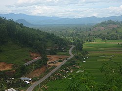
West Sumatra is a province of Indonesia. It is on the west coast of the island of Sumatra and includes the Mentawai Islands off that coast. West Sumatra borders the Indian Ocean to the west, as well as the provinces of North Sumatra to the north, Riau to the northeast, Jambi to the southeast, and Bengkulu to the south. The province has an area of 42,119.54 km2 (16,262.45 sq mi), with a population of 5,534,472 at the 2020 census. The official estimate at mid 2022 was 5,640,629. The province is subdivided into twelve regencies and seven cities. It has relatively more cities than other provinces outside Java, although several of them are relatively low in population compared with cities elsewhere in Indonesia. Padang is the province's capital and largest city.
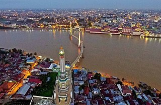
Pekanbaru is the capital city of the Indonesian province of Riau, and a major economic centre on the eastern side of Sumatra Island with its name derived from the Malay words for 'new market' . It has an area of 632.26 km2 (244.12 sq mi), with a population of 897,767 at the 2010 Census, and 983,356 at the 2020 Census; the official estimate as at mid 2022 was 1,007,540. It is located on the banks of the Siak River, which flows into the Strait of Malacca, Pekanbaru has direct access to the busy strait and has long been known as a trading port.

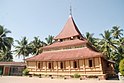
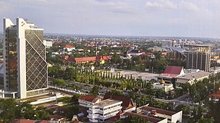
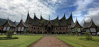
Padang is the capital and largest city of the Indonesian province of West Sumatra. It had a population of 833,562 at the 2010 Census and 909,040 at the 2020 Census; the official estimate as at mid 2022 was 919,145 - comprising 461,712 males and 457,433 females. It is the 16th most populous city in Indonesia and the most populous city on the west coast of Sumatra. The Padang metropolitan area is the third most populous metropolitan area in Sumatra with a population of over 1.4 million. Padang is widely known for its Minangkabau culture, cuisine, and sunset beaches.

Sibolga is a city and a port located in the natural harbour of Sibolga Bay on the west coast of North Sumatra province, in Indonesia.

Bukittinggi is the third largest city in West Sumatra, Indonesia, with a population of 111,312 in 2010 and 121,028 in 2020, and an official estimate as at mid 2022 of 122,311 - comprising 61,198 males and 61,113 females. It covers an area of 25.24 km2. It is located in the Minangkabau Highlands, 90 km by road from the West Sumatran capital city of Padang. The whole area directly borders to the Agam Regency, making it an enclave, and is located at 0°18′20″S100°22′9″E, near the volcanoes Mount Singgalang (inactive) and Mount Marapi. At 930 m above sea level, the city has a cool climate with temperatures between 16.1° to 24.9 °C.

North Jakarta is one of the five administrative cities which form Special Capital Region of Jakarta, Indonesia. North Jakarta is not self-governed and does not have a city council, hence it is not classified as a proper municipality. It contains the entire coastal area within the Jakarta Special District. North Jakarta, along with South Jakarta is the only two cities in Jakarta to border Banten and West Java. It is also the only two cities and regencies of Jakarta with a coastline and not landlocked along with the Thousand Islands Regency. North Jakarta, an area at the estuary of Ciliwung river was the main port for the kingdom of Tarumanegara, which later grew to become Jakarta. Many historic sites and artefacts of Jakarta can be found in North Jakarta. Both ports of Tanjung Priok and historic Sunda Kelapa are located in the city. The city, which covers an area of 139.99 km2, had 1,645,659 inhabitants at the 2010 census and 1,778,981 at the 2020 census; the official estimate as at mid 2022 was 1,793,550 - comprising 905,575 males and 887,975 females. It has its administrative centre in Tanjung Priok.
Padang Panjang, is a city located in the cool highlands of West Sumatra, inland from the provincial capital Padang. It sits on a plateau beneath the volcanoes Mount Marapi and Mount Singgalang. It has an area of 23.0 km² and a population at the 2010 Census of 47,008 and 56,311 at the 2020 Census; the official estimate as at mid 2022 was 57,850 - comprising 29,978 males and 28,772 females. It is located at 0°27′S100°25′E.

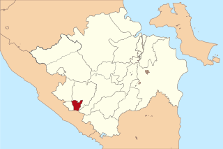
Solok is a city in West Sumatra, Indonesia. The motto of this city is Kota Beras which an abbreviation from "Bersih, Elok, Rapi, Aman dan Sejahtera". It has an area of 58.72 km2, a population of 59,396 at the 2010 Census, and 73,438 at the 2020 census; the official estimate as at mid 2022 was 75,850 - comprising 38,231 males and 37,619 females. Solok topography varies between the plains and hilly with a height of 390 m above sea level. There are three tributaries that cross Solok, namely Batang Lembang, Batang Gawan, and Batang Air Binguang.

Pariaman, is a coastal city in West Sumatra, Indonesia. Pariaman covers an area of 73.36 km2 (28 sq mi), with a 12 km (7 mi) coastline. It had a population of 79,043 at the 2010 Census and 94,224 at the 2020 census; the official estimate as at mid 2022 was 96,719 - comprising 48,864 males and 47,855 females. "Pariaman" means "safe area".

Dumai, is a coastal city in Riau Province on the island of Sumatra, Indonesia. The city has an area of 2,066.72 km2 and had 331,832 inhabitants at mid 2022 official estimate. Dumai has a domestic airport, Pinang Kampai Airport. Dumai is an important transport and trade centre, both regionally and internationally, especially to Malaysia. Dumai is rich in oil.
Jambi is the capital and largest city of the Indonesian province of Jambi. Located on the island of Sumatra, the city is a busy port on the Batang Hari River and an oil- and rubber-producing centre. The city is located 26 km (16 mi) from the ruins of Muaro Jambi Temple Compounds, an important city in the ancient Srivijaya kingdom.

Lima Puluh Kota Regency is a regency (kabupaten) of West Sumatra province, Indonesia. It has an area of 3,354.40 km2 and had a population of 348,249 at the 2010 census and 383,525 at the 2020 census; the official estimate as at mid 2022 was 388,375 - comprising 194,292 males and 194,083 females. The regency seat is the town of Sarilamak.
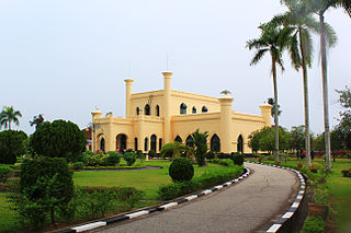
Siak, is a regency (kabupaten) of Riau Province, on the island of Sumatra, Indonesia. It has an area of 8,556.09 km² and had a population of 376,742 at the 2010 Census and 457,940 at the 2020 Census; the official estimate as at mid 2022 was 477,550, comprising 246,186 males and 231,364 females. The administrative centre of the regency is located at Siak Sri Indrapura. The northern part of this regency contains a large part of the Bukit Batu Biosphere Reserve.
Pagar Alam, is a city in South Sumatra, Indonesia. It was formerly part of Lahat Regency, from which it was separated as an independent city on 21 June 2001; before being established as an independent city, Pagar Alam was an administrative city within Lahat Regency. It has an area of 633.66 km2 and a population of 126,181 at the 2010 Census and 143,844 at the 2020 Census; the official estimate as at mid 2022 was 147,071.

Serang is a city and the capital of Banten province and was formerly also the administrative center of Serang Regency in Indonesia. The city is located towards the north of Banten province, on the island of Java; the north part of the city contains the coast zone facing onto Banten Bay, and includes the historical site of Old Banten, after which the province is named. Before Banten province was formed in 2000, Serang city was part of West Java province.
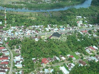
Mukomuko is a regency of Bengkulu Province, Indonesia, on the island of Sumatra. It was originally part of the North Bengkulu Regency, but on 25 February 2003 that regency was split into two parts, the northwestern part created as a separate Mukomuko Regency. It covers a land area of 4,146.52 km2 and had a population of 155,753 at the 2010 census, which rose to 190,498 at the 2020 census; the official estimate as at mid 2022 was 196,571. The administrative centre of the Mukomuko Regency is Mukomuko town.

Tanggamus Regency is a regency (kabupaten) of Lampung Province, Sumatra, Indonesia. It has an area of 4,654.96 km² and had a population of 534,595 at the 2010 Census and 640,275 at the 2020 Census; the official estimate as at mid 2022 was 652,898. The regency seat is the town of Kota Agung Pusat. The regency was created on 21 March 1997, but districts in its eastern part were split away on 29 October 2008 to form a new Pringsewu Regency. It lies in the southwest of the province, and surrounds Semangka Bay on its west, north and east coasts.