Permanently signed detour route

Last updated

A permanently signed detour route (also known as an emergency detour route or emergency diversion route) is a type of route which is used temporarily during special circumstances. Various areas have developed these systems as part of incident management. The purpose of these routes is to provide a detour in the event that the parent route is impassable, due to either a traffic jams, traffic collision, or road closure (for a variety of reasons). Sometimes these routes are signed as a prefixed or suffixed numbered road, making them a type of special route.

Contents

A permanently signed detour route should not be confused with a "permanent detour". The latter would be used if a particular roadway section, such as a bridge, were closed permanently. [lower-alpha 1]

Canada

Ontario

An emergency detour route (EDR) sign on Ontario Highway 401 Highway 401 Emergency Detour Route sign.svg
An emergency detour route (EDR) sign on Ontario Highway 401

The province of Ontario in Canada is one jurisdiction outside the United States with a very prevalent system of these roads. The Emergency Detour Routes, originally Emergency Diversion Routes (EDR), are a system of temporary detour routes paralleling many major highways in Ontario. Most of these follow county or municipal roads within the province that are not (currently) provincially controlled (though many were former provincial highways). These routes are designed to be used in the event of a closure on a major road or 400-series highway, such as construction or serious collisions.

Though most EDRs are set up along 400-series highways, a select few have been established along two lane King's Highways, notably Highway 21 due to the lake effect of Lake Huron, which can result in sudden snowsquall conditions during the winter.

History

Halton was the first jurisdiction in Ontario to create EDRs, although it initially referred to them as Emergency Diversion Routes. In August 1999, the regional council approved the preparation of the Road Closure Action Plan (RCAP), which was developed with input from the Halton Regional Police Services and the Ministry of Transportation of Ontario (MTO). [2] The RCAP utilized folding signs that police could open to "activate" the route. Similar in appearance to the EDR signs of today, the RCAP signs featured a trapezoid shaped orange EDR sign, as opposed to an orange square with a black circle containing the letters EDR. These signs were first deployed along a limited stretch of the Queen Elizabeth Way in March 2001, [3] between Dorval Drive and Trafalgar Road in Oakville and between Bronte Road and Burloak Drive in Burlington, both the location of major ravines with limited alternative crossings. [4]

By the spring of 2003, when the deployment of the system was complete, the entire Queen Elizabeth Way, Highway 401 and Highway 403 had diversion routes within Halton Region. [2] [4] Following Halton's tests, the MTO and the Ontario Good Roads Association formed a joint task force, and using the RCAP as a model, developed the Emergency Detour Route program. [2]

In 2010 and 2011, an aggressive program was instituted to place EDRs alongside major routes throughout the province. [5] [6] [7] [8]

Alberta

Highway 2 uses Highway 2A as an Emergency Detour Route. On Highway 2, there are signs with flashing lights indicating when to take the next exit to use the detour route.

Germany

Zeichen 460.svg
Autobahn "on-demand" detour sign
Zeichen 466 - Bedarfsumleitungstafel, StVO 1970.svg
Sign showing continuation of detour over next sequential detour route

Every exit on the German Autobahn and some other expressways has a pre-posted "on-demand" detour route (German: Bedarfsumleitung) marked with a blue and white sign having a number starting with a "U" (short for "Umleitung", German for "detour".) In the event an Autobahn segment must be closed due to a crash, road work, or other incident, drivers can be diverted off the Autobahn to follow the numbered signs over the adjacent secondary road network to the next downstream Autobahn entrance. In the event that entrance is also closed, signs will indicate to motorists to follow the next sequentially-numbered route. Odd-numbered detour routes are used for northbound and eastbound travel, while even-numbered routes are used for southbound and westbound travel. The detours can also optionally be used to circumnavigate traffic jams.

As the detours use secondary roadways, federal administrative rules require consultation with local authorities when planning the detour routes, and routes are selected to minimize distance, stops (i.e. traffic signals), and disruption to nearby communities as much as possible. [9] [10] [11]

Sweden

Sweden road sign F15.svg
Road number sign for traffic diversion
Sweden road sign F14-3.svg
For comparison, a road number sign for the main route

Sweden use signs with white background and blue text for their permanent detour routes (Swedish: permanent omledningsväg) on numbered roads. According to the Swedish Transport Administration's guidelines a permanent detour route should be able to handle all the traffic when it comes to capacity, weight, height, etc. as sorting traffic is almost impossible. In cases that for some reason need traffic sorting the police will regulate the traffic. However, there may be different routes for different travel directions as to not create accessibility problems or queues due to limited capacity; in these cases a letter for the cardinal direction is added at the end. The guidelines also emphasize that the segments of the permanent detour route should be as short as possible with access to the main route whenever it is possible. [12]

United Kingdom and Ireland

EDR Symbol - Solid Square.svg
An emergency diversion route symbol, a solid square
EDR Symbol - Hollow Square.svg
An emergency diversion route symbol, a hollow square
UK traffic sign 2716.svg
A trigger sign, used to indicate which symbol to follow when a route is closed

The United Kingdom and the Republic of Ireland use yellow signs with a series of symbols for their emergency diversion routes. [13] Symbols come in a shapes, with a solid and hollow version, including circle, triangle, square and diamond. When a roadway is closed, a trigger sign is opened at the last junction prior to the closure, displaying a symbol, which motorists can follow to rejoin the route at a point beyond the closure. [14]

United States

The national Manual on Uniform Traffic Control Devices introduced signage for these routes in its eleventh edition in December 2023. [15] Some states had adopted their own systems prior to this.

Michigan

Emergency plate Emergency plate.svg
Emergency plate
Emergency I-94 shields in Coloma, Michigan Clmei94.jpg
Emergency I-94 shields in Coloma, Michigan

Michigan has a system of special routes called "Emergency" routes which parallel major highways, primarily in Southwestern Michigan. These routes provide relief in the event of emergency closures to a freeway due to accidents, weather, or other civil emergencies. Emergency routes have been gradually put in place as part of a broader plan by the Michigan Department of Transportation (MDOT) to upgrade its ITS network across the state. These detours may or may not follow MDOT-maintained State Highways, however, and some portions of the routes pass through urban or suburban areas. [16] Emergency routes exist on and parallel to Interstate 69 (I-69) [17] and I-94 [16] and US Highway 31 (US 31). [18]

These routes are signed with an auxiliary "Emergency" plate that is colored orange, indicating a temporary traffic control sign.

Emergency US 31, which offers an alternative crossing of the Grand River in the event that the bascule bridge in Grand Haven, Michigan is unavailable for motorists, [19] is one such route. According to MDOT, "this route would only be used in emergency situations and worst-case scenarios impacting the entire bridge structure." [19]

Missouri

Missouri uses "Incident By-Pass Routes" along its highways. [20]

Nebraska

Nebraska has created an alternate route for Interstate 80. [21] [22]

New York

The New York State Thruway uses emergency detour signs to divert traffic from the Thruway in the event of weather conditions or other emergencies. [23] [24]

Ohio

I-76, I-76/US 224 Alt, and I-77 alt at Ohio State Route 21 in Norton To Northbound OH SR 21 from Eastbound I-76.png
I-76, I-76/US 224 Alt, and I-77 alt at Ohio State Route 21 in Norton

Ohio has established a permanent detour scenario of Interstate 70 east of Columbus, due to frequent flooding. [25]

Alternate Interstate routes also exist for I-70 near Dayton [26] as well as for Interstate 76 and Interstate 77 in Summit County.

Pennsylvania

Green and orange detour signs in Pennsylvania PA 363 shields on Egypt Road.jpg
Green and orange detour signs in Pennsylvania

Pennsylvania has a system of "color detour signs" in which any detour follows signs with a specific color. [27] [28] [29] The detours are meant to be used if a limited-access highway has to be closed for an emergency situation such as a flood or car accident, directing motorists along local roads near the limited-access highway to the next exit. According to a document produced by the Delaware Valley Regional Planning Commission containing information from the Pennsylvania Department of Transportation, they are generally color-coded according to direction, with blue meaning north, red meaning south, green meaning east, and orange meaning west, with other colors sometimes being used when detour routes overlap with one another. [28] [30] However, the Pennsylvania Department of Transportation's own sign manual recommends that only black, blue, or orange be used. [31]

West Virginia

The West Virginia Turnpike has a series of lettered detours, first posted in early 2012, along its route. [32] [33]

Wisconsin

Wisconsin has "alternate route designations" on local surface roads and streets for all five primary interstate highways and three auxiliary interstates, along with several U.S. highways and state trunk highways. [34]

Notes

  1. For example, "The Pinkerton Tunnel, near Markleton, remains closed with a detour on abandoned rail line following the river. This is a permanent detour, there are no plans to reconstruct this tunnel." [1]

Related Research Articles

<span class="mw-page-title-main">Interstate 696</span> Interstate Highway in Oakland and Macomb counties in Michigan, United States

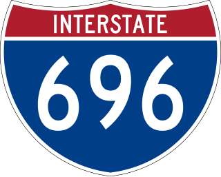
Interstate 696 (I-696) is an east–west auxiliary Interstate Highway in the Metro Detroit region of the US state of Michigan. The state trunkline highway is also known as the Walter P. Reuther Freeway, named for the prominent auto industry union head by the Michigan Legislature in 1971. I-696 is a bypass route, detouring around the city of Detroit through the city's northern suburbs in Oakland and Macomb counties. It starts by branching off I-96 and I-275 at its western terminus in Farmington Hills, and runs through suburbs including Southfield, Royal Oak and Warren before merging into I-94 at St. Clair Shores on the east end. It has eight lanes for most of its length and is approximately 10 miles (16 km) north of downtown Detroit. I-696 connects to other freeways such as I-75 and M-10. Local residents sometimes refer to I-696 as "The Autobahn of Detroit".

<span class="mw-page-title-main">Interstate 496</span> Interstate Highway in Eaton and Ingham counties in Michigan, United States

Interstate 496 (I-496) is an auxiliary Interstate Highway that passes through downtown Lansing in the US state of Michigan. Also a component of the State Trunkline Highway System, the freeway connects I-96 to the downtown area. It has been named the R.E. Olds Freeway for Ransom E. Olds, the founder of Oldsmobile and the REO Motor Car Company. I-496 runs east–west from I-96/I-69 near the downtown area and north–south along a section that runs concurrently with US Highway 127 (US 127). The trunkline also passes a former assembly plant used by Oldsmobile and runs along or crosses parts of the Grand and Red Cedar rivers.

<span class="mw-page-title-main">Interstate 296</span> Unsigned Interstate Highway in Michigan, United States

Interstate 296 (I-296) is a part of the Interstate Highway System in the US state of Michigan. It is a north–south state trunkline highway that runs for 3.43 miles (5.52 km) entirely within the Grand Rapids area. Its termini are I-196 near downtown Grand Rapids and I-96 on the north side of Grand Rapids in Walker. For most of its length, the Interstate runs concurrently with U.S. Highway 131 (US 131), which continues as a freeway built to Interstate Highway standards north and south of the shorter I-296. The highway was first proposed in the late 1950s and opened in December 1962, but the Michigan Department of Transportation (MDOT) has since eliminated all signage for I-296 and removed the designation from their official state map. The designation is therefore unsigned, but still listed on the Interstate Highway System route log maintained by the Federal Highway Administration (FHWA).

<span class="mw-page-title-main">M-6 (Michigan highway)</span> State highway in Michigan, United States

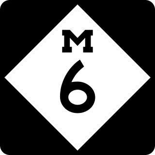
M-6, or the Paul B. Henry Freeway, is a 19.7-mile-long (31.7 km) east–west freeway and state trunkline highway in the United States that serves portions of southern Kent and eastern Ottawa counties south of Grand Rapids, Michigan. Although the freeway is named for Paul B. Henry, local residents and the press continue to use the original name, South Beltline as well on occasion. The freeway connects Interstate 196 (I-196) on the west with I-96 on the east. M-6 also provides a connection to U.S. Highway 131 (US 131) in the middle of its corridor while running through several townships on the south side of the Grand Rapids metropolitan area in Western Michigan. Each end is in a rural area while the central section has suburban development along the trunkline.

<span class="mw-page-title-main">Concurrency (road)</span> Road bearing more than one route number

A concurrency in a road network is an instance of one physical roadway bearing two or more different route numbers. When two roadways share the same right-of-way, it is sometimes called a common section or commons. Other terminology for a concurrency includes overlap, coincidence, duplex, triplex, multiplex, dual routing or triple routing.

<span class="mw-page-title-main">M-13 Connector (Michigan highway)</span> State highway in Michigan

Connector M-13 is a north–south state trunkline highway running 2.41 miles (3.88 km) connecting Interstate 75/US Highway 23 (I-75/US 23) to M-13 near the community of Kawkawlin, just north of Bay City. The Michigan Department of Transportation (MDOT) internally calls the road Connector 13. The freeway was once the northern end of the US 23 freeway in the area before I-75 was built to the northwest and US 23 was rerouted to follow it. When these changes were made in 1967, Conn. M-13 was designated for the freeway stub.

<span class="mw-page-title-main">Interstate 86 (Pennsylvania–New York)</span> Highway in the United States

Interstate 86 (I-86) is an Interstate Highway that extends for 223.39 miles (359.51 km) through northwestern Pennsylvania and the Southern Tier region of New York, in the United States. The highway has two segments: the longer of the two begins at an interchange with I-90 east of Erie, Pennsylvania, and ends just beyond the Chemung-Tioga county line at the Pennsylvania border, while the second extends from I-81 east of Binghamton to New York State Route 79 (NY 79) in Windsor. When projects to upgrade the existing NY 17 to Interstate Highway standards are completed, I-86 will extend from I-90 near Erie to the New York State Thruway (I-87) in Woodbury. The portion in Erie County, Pennsylvania, is known as the Hopkins-Bowser Highway and is signed as such at each end. In New York, the current and future alignment of I-86 is known as the Southern Tier Expressway west of I-81 in Binghamton and the Quickway east of I-81.

<span class="mw-page-title-main">Interstate 375 (Michigan)</span> Interstate Highway in Detroit, Wayne County, Michigan, United States

Interstate 375 (I-375) is a north–south auxiliary Interstate Highway in Detroit, Michigan, United States. It is the southernmost leg of the Walter P. Chrysler Freeway and a spur of I-75 into Downtown Detroit, ending at the unsigned Business Spur I-375, better known as Jefferson Avenue. The freeway opened on June 12, 1964. At only 1.062 miles (1.709 km) in length, it once had the distinction of being the shortest signed Interstate Highway in the country before I-110 in El Paso, Texas, was signed. The Michigan Department of Transportation (MDOT) announced in 2021 plans to convert the freeway to a boulevard. Details of that project were revealed in April 2023 with MDOT reaffirming that construction is scheduled to begin in 2025.

<span class="mw-page-title-main">Interstate 275 (Michigan)</span> Interstate Highway in Michigan, United States

Interstate 275 (I-275) is an auxiliary Interstate Highway in the US state of Michigan that acts as a western bypass of the Detroit metropolitan area. The Michigan Department of Transportation (MDOT) maintains the highway as part of the larger State Trunkline Highway System. The freeway runs through the western suburbs near Detroit Metropolitan Wayne County Airport, and crosses several rivers and rail lines in the area. The southern terminus is the interchange with I-75 near Newport, northeast of Monroe. MDOT considers the Interstate to run to an interchange with I-96, I-696 and M-5 on the Farmington Hills–Novi city line, running concurrently with I-96 for about five miles (8.0 km). This gives a total length of about 35.03 miles (56.38 km), which is backed up by official signage. According to the Federal Highway Administration (FHWA), the length is 29.97 miles (48.23 km) because that agency considers I-275 to end at the junction with I-96 and M-14 along the boundary between Livonia and Plymouth Township. All other map makers, like the American Automobile Association, Rand McNally and Google Maps follow MDOT's practice.

<span class="mw-page-title-main">Interstate 675 (Michigan)</span> Interstate Highway in Saginaw County, Michigan, United States

Interstate 675 (I-675) is an auxiliary Interstate Highway in the US state of Michigan. The freeway is a 7.7-mile-long (12.4 km) loop route through downtown Saginaw, as I-75 passes on the east side of the city. I-675 is also a state trunkline highway that provided a bypass of the former drawbridge carrying I-75 and US Highway 23 (US 23) across the Saginaw River. Construction of I-675 started in 1969 and the freeway opened in 1971. Since then, sections near downtown were reconstructed between 2009 and 2011 to update one of the freeway's interchanges and rebuild the bridge over the Saginaw River.

Contraflow lane reversal is the altering of the normal flow of traffic, typically on a controlled-access highway, to either aid in an emergency evacuation or, as part of routine maintenance activities, to facilitate widening or reconstruction of one of the highway's carriageways.

The Michigan Department of Transportation (MDOT) is a constitutional government principal department of the US state of Michigan. The primary purpose of MDOT is to maintain the Michigan State Trunkline Highway System which includes all Interstate, US and state highways in Michigan with the exception of the Mackinac Bridge. Other responsibilities that fall under MDOT's mandate include airports, shipping and rail in Michigan.

<span class="mw-page-title-main">Capitol Loop</span> State highway in Lansing, Ingham County, Michigan, United States

The Capitol Loop is a state trunkline highway running through Lansing, Michigan, in the United States that was commissioned on October 13, 1989. It forms a loop route off Interstate 496 (I-496) through downtown near the Michigan State Capitol complex, home of the state legislature and several state departments. The Michigan Department of Transportation (MDOT) has labeled it as Capitol Loop I-496 or CL I-496 on some maps, similar to the Business Loop Interstate nomenclature. However, unlike other business loops in Michigan, it has unique reassurance markers—the signs that serve as regular reminders of the name and number of the highway. It is known internally at MDOT as Connector 496 for inventory purposes. The route follows a series of one-way and two-way streets through downtown Lansing, directing traffic downtown to the State Capitol and other government buildings. Unlike the other streets downtown, the seven streets comprising the Capitol Loop are under state maintenance and jurisdiction.

<span class="mw-page-title-main">Bypass (road)</span> Road which bypasses a built-up area

A bypass is a road or highway that avoids or "bypasses" a built-up area, town, or village, to let through traffic flow without interference from local traffic, to reduce congestion in the built-up area, and to improve road safety. A bypass specifically designated for trucks may be called a truck route.

<span class="mw-page-title-main">U.S. Route 131</span> US Highway in Indiana and Michigan

US Highway 131 (US 131) is a north–south United States Highway, of which all but 0.64 of its 269.96 miles are within the state of Michigan. The highway starts in rural Indiana south of the state line as a state road connection to the Indiana Toll Road. As the road crosses into Michigan it becomes a state trunkline highway that connects to the metropolitan areas of Kalamazoo and Grand Rapids before continuing north to its terminus at Petoskey. US 131 runs as a freeway from south of Portage through to Manton in the north. Part of this freeway runs concurrently with Interstate 296 (I-296) as an unsigned designation through Grand Rapids. US 131 forms an important corridor along the western side of the Lower Peninsula of Michigan, running through rural farm and forest lands as well as urban cityscapes. Various names have been applied to the roadway over the years. The oldest, the Mackinaw Trail, originated from an Indian trail in the area while other names honored politicians. An attempt to dedicate the highway to poet James Whitcomb Riley failed to gain official support in Michigan.

<span class="mw-page-title-main">Special route</span> Type of United States road

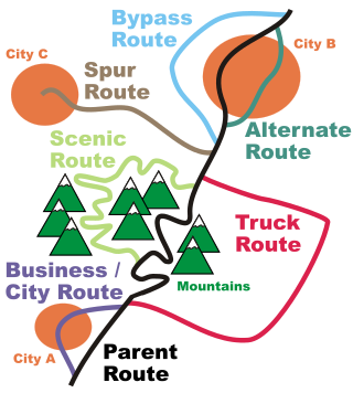
In road transportation in the United States, a special route is a road in a numbered highway system that diverts a specific segment of related traffic away from another road. They are featured in many highway systems; most are found in the Interstate Highway System, U.S. highway system, and several state highway systems. Each type of special route possesses generally defined characteristics and has a defined relationship with its parent route. Typically, special routes share a route number with a dominant route, often referred as the "parent" or "mainline", and are given either a descriptor which may be used either before or after the route name, such as Alternate or Business, or a letter suffix that is attached to the route number. For example, an alternate route of U.S. Route 1 may be called "Alternate U.S. Route 1", "U.S. Route 1 Alternate", or "U.S. Route 1A". Occasionally, a special route will have both a descriptor and a suffix, such as U.S. Route 1A Business.

<span class="mw-page-title-main">U.S. Route 41 in Michigan</span> U.S. Highway in Michigan

US Highway 41 (US 41) is a part of the United States Numbered Highway System that runs from Miami, Florida, to the Upper Peninsula of the US state of Michigan. In Michigan, it is a state trunkline highway that enters the state via the Interstate Bridge between Marinette, Wisconsin, and Menominee, Michigan. The 278.769 miles (448.635 km) of US 41 that lie within Michigan serve as a major conduit. Most of the highway is listed on the National Highway System. Various sections are rural two-lane highway, urbanized four-lane divided expressway and the Copper Country Trail National Scenic Byway. The northernmost community along the highway is Copper Harbor at the tip of the Keweenaw Peninsula. The trunkline ends at a cul-de-sac east of Fort Wilkins State Park after serving the Central Upper Peninsula and Copper Country regions of Michigan.

<span class="mw-page-title-main">Detour</span> Diversion on a route

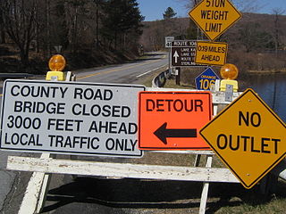
A detour or is a route taking traffic around an area of prohibited or reduced access, such as a construction site. Standard operating procedure for many roads departments is to route any detour over roads within the same jurisdiction as the road with the obstructed area.

<span class="mw-page-title-main">Michigan State Trunkline Highway System</span> Highway system in Michigan

The State Trunkline Highway System consists of all the state highways in Michigan, including those designated as Interstate, United States Numbered, or State Trunkline highways. In their abbreviated format, these classifications are applied to highway numbers with an I-, US, or M- prefix, respectively. The system is maintained by the Michigan Department of Transportation (MDOT) and comprises 9,669 miles (15,561 km) of trunklines in all 83 counties of the state on both the Upper and Lower peninsulas, which are linked by the Mackinac Bridge. Components of the system range in scale from 10-lane urban freeways with local-express lanes to two-lane rural undivided highways to a non-motorized highway on Mackinac Island where cars are forbidden. The longest highway is nearly 400 miles (640 km) long, while the shortest is about three-quarters of a mile. Some roads are unsigned highways, lacking signage to indicate their maintenance by MDOT; these may be remnants of highways that are still under state control whose designations were decommissioned or roadway segments left over from realignment projects.

References

  1. "Trail Status". Great Allegheny Passage. Archived from the original on July 25, 2013. Retrieved July 8, 2013.
  2. 1 2 3 Murphy, Patrick (February 17, 2004). Ministry of Transportation's Emergency Detour Route Guidelines and Best Practices Initiative (PDF) (Report). Regional Municipality of Halton. Retrieved September 15, 2011.[ permanent dead link ]
  3. Legall, Paul (February 9, 2001). "Halton Key to Unlocking Traffic Gridlock; Will Test Redirection Schemes for Other Cities". The Hamilton Spectator. Torstar. p. A02.
  4. 1 2 Murphy, Patrick (September 25, 2002). Halton Region Road Closure Action Plan (RCAP) Update: Phases 2 and 3 (PDF) (Report). Regional Municipality of Halton. Retrieved September 15, 2011.[ permanent dead link ]
  5. City of Ottawa. Ottawa Gets Emergency Detour Routes Archived 2014-02-21 at the Wayback Machine . Accessed on September 15, 2011.
  6. Emergency detour routes help drivers get out of park Archived 2012-03-25 at the Wayback Machine . Accessed on September 15, 2011.
  7. United Counties to Establish 401 and 416 Emergency Detour Routes (EDRs) Archived 2012-03-27 at the Wayback Machine . Accessed on September 15, 2011.
  8. Emergency Detour Routes Show Drivers the Best Route When the Highways Close [ permanent dead link ]. Accessed on September 15, 2011.
  9. "Bedarfsumleitungen: "Wenn auf der Autobahn nichts mehr geht"" [On-demand detours: "When the Autobahn isn't working"](PDF). Straßenverkehrszentrale Baden-Württemberg (in German). Retrieved 2022-04-08.
  10. "Straßenverkehrs-Ordnung (StVO) Anlage 3 (zu § 42 Absatz 2) Richtzeichen" [Road Traffic Regulations (StVO) Appendix 3 (to § 42 paragraph 2) direction signs]. Gesetze im Internet (in German). Retrieved 2022-04-08.
  11. "Allgemeine Verwaltungsvorschrift zur Straßenverkehrs-Ordnung (VwV-StVO) Vom 26. Januar 2001" [General administrative regulation for road traffic regulations]. Verwaltungsvorschriften (in German). Retrieved 2022-04-08.
  12. Vikström, Gunnar (2011-09-13). "Omledning av trafik" [Redirection of traffic](PDF). Trafikverket (in Swedish). Archived (PDF) from the original on 2018-12-30. Retrieved 2018-12-30.
  13. "Signs and Markings: Direction Signs". Highway Code . Her Majesty's Stationery Office.
  14. "Know Your Traffic Signs" (PDF). Her Majesty's Stationery Office. p. 107.
  15. "Section 2D.59 Emergency Routing Signs and Plaques (M4-11 and M4-12 Series)". Manual on Uniform Traffic Control Devices, Chapter 2D (PDF) (11th ed.). Federal Highway Administration. 2023. p. 279-281.
  16. 1 2 "Southwest Region and Portions of University Region Final Regional ITS Deployment Plan (part 2)" (PDF). Michigan Department of Transportation. January 24, 2008. Retrieved July 22, 2012.
  17. Schirripa, Nick (January 26, 2010). "I-69 Emergency Route Sign Installation Starts Jan. 26" (Press release). Michigan Department of Transportation. Retrieved February 24, 2010.
  18. Terry, Tim (March 11, 2009). "MDOT Installs New Emergency Signs on US 31" (Press release). Michigan Department of Transportation. Archived from the original on February 1, 2014. Retrieved July 22, 2012.
  19. 1 2 Kohrman, Benjamin (August 19, 2005). "MDOT Establishes US 31/Bascule Bridge Emergency Detour Routes" (Press release). Michigan Department of Transportation. Retrieved August 3, 2012.
  20. Engineering Policy Group (June 2007). "Incident By-Pass Route (EM-10) Signing" (PDF). Missouri Department of Transportation. Technical Bulletin Number 2. Archived from the original (PDF) on February 3, 2016. Retrieved July 8, 2013.{{cite web}}: |author= has generic name (help)
  21. Nebraska Department of Roads (2011). Supplement to the Manual on Uniform Traffic Control Devices (PDF). p. M-3. Signs M4-1E and M4-1W.
  22. Google (June 2013). "US-34 Hampton, Nebraska". Google Street View . Retrieved July 25, 2018.{{cite web}}: |author= has generic name (help)
  23. "Emergency Detour Routes". NY State Thruway.
  24. McDermott, Meaghan M. (January 12, 2016). "Thruway Authority posts emergency detour routes". Democrat and Chronicle . Rochester, New York . Retrieved March 11, 2018.
  25. District 5 staff. "I-70 Detour for High Water Event between SR37 and SR79" (PDF). Ohio Department of Transportation . Retrieved August 3, 2012.{{cite web}}: CS1 maint: numeric names: authors list (link)
  26. Google Street View (October 2017). "2931 US-40 Dayton, Ohio" . Retrieved July 25, 2018.{{cite web}}: |author= has generic name (help)
  27. "Red Detour, Black Detour, Green Detour, Blue Detour: What's It All About?" (Press release). Pennsylvania Department of Transportation. October 10, 2000.
  28. 1 2 Carey, Art (January 11, 2008). "PennDot Targets Tie-Ups with Color". The Philadelphia Inquirer .
  29. "Mystery Of New Color-Coded Detour Signs Answered". Philadelphia: WCAU-TV. January 3, 2008. Archived from the original on January 9, 2008. Retrieved July 22, 2008.
  30. "PennDOT Detour Signs". Delaware Valley Regional Planning Commission; Pennsylvania Department of Transportation. Retrieved May 2, 2020 via Chester County, Pennsylvania.
  31. Pennsylvania Department of Transportation (2013). Publication 236: Handbook of Approved Signs (PDF). pp. 733–734. Archived from the original (PDF) on 18 October 2020. Appropriate colors should generally be limited to blue, orange or black. - Signs: D14-101 "Emergency Detour — Follow (Color) Arrow Sign" and D14-102 "Emergency Detour (Color) Trailblazer Sign".
  32. Cahill, Samantha (March 23, 2012). "Lewisburg Emergency Detour Signs Highlight Alternate Routes". Lewisburg, WV: WVNS-TV . Retrieved September 10, 2012.
  33. HNTB Corporation (December 21, 2011). "West Virginia Turnpike Incident Management: Emergency Traffic Control Plan" (PDF). West Virginia Parkways Authority. pp. 17–25. Retrieved September 18, 2012.
  34. Statewide Traffic Operations Center (November 2014). "WisDOT Emergency Traffic Control and Scene Management Guidelines" (PDF). Wisconsin Department of Transportation. pp. 48–49. Retrieved July 28, 2016.