The Embarcadero is the eastern waterfront of Port of San Francisco and a major roadway in San Francisco, California. It was constructed on reclaimed land along a three mile long engineered seawall, from which piers extend into the bay. It derives its name from the Spanish verb embarcar, meaning "to embark"; embarcadero itself means "the place to embark." The Central Embarcadero Piers Historic District was added to the National Register of Historic Places on November 20, 2002.

Pier 39 is a shopping center and popular tourist attraction built on a pier in San Francisco, California. At Pier 39, there are shops, restaurants, a video arcade, street performances, the Aquarium of the Bay, virtual 3D rides, and views of California sea lions hauled out on docks on Pier 39's marina. A two-story carousel is one of the pier's more dominant features, although it is not directly visible from the street and sits towards the end of the pier. The family-oriented entertainment and presence of marine mammals make this a popular tourist location for families with kids.
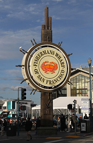
Fisherman's Wharf is a neighborhood and popular tourist attraction in San Francisco, California, United States. It roughly encompasses the northern waterfront area of San Francisco from Ghirardelli Square or Van Ness Avenue east to Pier 35 or Kearny Street. The F Market streetcar runs through the area, the Powell-Hyde cable car line runs to Aquatic Park, at the edge of Fisherman's Wharf, and the Powell-Mason cable car line runs a few blocks away.

The Berkeley Pier is in Berkeley, California. When constructed in 1926, the pier extended 3.5 miles (5.6 km) into San Francisco Bay from the end of University Avenue. Due to extensive filling of the bay and the creation of the Berkeley Marina, it presently extends only 2.5 miles (4.0 km). Since 1937, only the first 3,000 feet (910 m) were maintained and open to the public until July 2015, when public access was closed due to safety concerns.

The Port of San Francisco is a semi-independent organization that oversees the port facilities at San Francisco, California, United States. It is run by a five-member commission, appointed by the Mayor and approved by the Board of Supervisors. The Port is responsible for managing the larger waterfront area that extends from the anchorage of the Golden Gate Bridge, along the Marina district, all the way around the north and east shores of the city of San Francisco including Fisherman's Wharf and the Embarcadero, and southward to the city line just beyond Candlestick Point. In 1968, the State of California, via the California State Lands Commission for the State-operated San Francisco Port Authority, transferred its responsibilities for the Harbor of San Francisco waterfront to the City and County of San Francisco / San Francisco Harbor Commission through the Burton Act AB2649. All eligible State port authority employees had the option to become employees of the City and County of San Francisco to maintain consistent operation of the Port of San Francisco.

The Hyde Street Pier, at 2905 Hyde Street, is a historic ferry pier located on the northern waterfront of San Francisco in the U.S. state of California.

The Berkeley Marina is the westernmost portion of the city of Berkeley, California, located west of the Eastshore Freeway at the foot of University Avenue on San Francisco Bay. Narrowly speaking, "Berkeley Marina" refers only to the city marina, but in common usage, it applies more generally to the surrounding area.
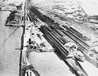
The Oakland Long Wharf was an 11,000-foot railroad wharf and ferry pier along the east shore of San Francisco Bay located at the foot of Seventh Street in West Oakland. The Oakland Long Wharf was built, beginning 1868, by the Central Pacific Railroad on what was previously Oakland Point. Beginning November 8, 1869, it served as the west coast terminus of the First transcontinental railroad. In the 1880s, Southern Pacific Railroad took over the CPRR, extending it and creating a new ferry terminal building with the official station name Oakland Pier. The entire structure became commonly and popularly called the Oakland Mole. Portions of the Wharf lasted until the 1960s. The site is now part of the facilities of the Port of Oakland, while passenger train service operates at the nearby Jack London Square/Dellums Station and another nearby station in Emeryville.

San Francisco Bay in California has been served by ferries of all types for over 150 years. John Reed established a sailboat ferry service in 1826. Although the construction of the Golden Gate Bridge and the San Francisco–Oakland Bay Bridge led to the decline in the importance of most ferries, some are still in use today for both commuters and tourists.

San Francisco Bay Ferry is a public transit passenger ferry service in the San Francisco Bay, administered by the San Francisco Bay Area Water Emergency Transportation Authority (WETA) and operated under contract by the privately owned, Blue and Gold Fleet. In 2022, the system had a ridership of 1,787,400, or about 9,400 per weekday as of the second quarter of 2023.

The Vallejo Station was created by combining the Vallejo Ferry Terminal, the Vallejo Transit Center bus station, and a connecting multi-story parking garage and paseo. It is designed to be an inter-modal transit station in Vallejo, California. It is located in the western part of Central Vallejo.

Jefferson and Powell station is a light rail station in the Fisherman's Wharf district of San Francisco, California, serving the San Francisco Municipal Railway's E Embarcadero and F Market & Wharves heritage railway lines. It is located on Jefferson Street at Powell Street. The station opened on March 4, 2000, with the streetcar's extension to Fisherman's Wharf.

The Oakland Ferry Terminal is a ferry terminal on the San Francisco Bay, located in Jack London Square in Oakland, California.

Alcatraz Wharf is located on the southeast side of Alcatraz Island, in San Francisco Bay, California, US. Classified as building number 33 of the Alcatraz Island National Historic Landmark, its historic name variants were "Alcatraz Dock" and "Alcatraz Pier". It is the main access point to Alcatraz. Another dock on the island's northwest side was only used for rock loading. The wharf contained many of the islands historic buildings, including Building 64, the Bombproof Barracks, Chinatown, Ranger Office, Garage, Dock Tower, Storage Vault, and Firebox #3.
Alioto's Restaurant is a historic Italian fish restaurant located at San Francisco's Fisherman's Wharf.

Meiggs' Wharf was an L-shaped wooden pier extending between 1,600 and 2,000 feet from the northern San Francisco shoreline, an exceptional distance for its time. It was built by transplanted Bostonian Henry Meiggs to attract the lumber shipping trade as part of his real estate development plans for what would become the North Beach area of San Francisco. Though it bankrupted him in the process, it would become a major part of North Beach and San Francisco society life.
Madame Tussauds San Francisco is a wax museum located in Fisherman's Wharf, San Francisco in California. The attraction opened on June 26, 2014 and became the 17th Madame Tussauds museum to open worldwide. The attraction features wax figures of famous figures from movies, music, politics, popular culture and sport. It also celebrates “The Spirit of San Francisco” with wax figures of local artists, musicians and activists from the city's past.

Forbes Island is a floating island and event space near Bradford Island, California, United States. It was formerly a restaurant, located between Pier 39 and Pier 41 in Fisherman's Wharf, San Francisco. It was the only "floating island" restaurant in the Bay Area. The restaurant was inspired by Captain Nemo's marine dwelling. The restaurant closed in 2017, and the floating platform was moved to the Holland Riverside Marina in Brentwood, California.