
Alameda is a city in Alameda County, California, United States, located in the East Bay region of the Bay Area. The city is primarily located on Alameda Island, but also spans Bay Farm Island and Coast Guard Island, as well as a few other smaller islands in San Francisco Bay. As of the 2020 census, the city's population was 78,280.

AC Transit is an Oakland-based public transit agency serving the western portions of Alameda and Contra Costa counties in the East Bay of the San Francisco Bay Area. AC Transit also operates "Transbay" routes across San Francisco Bay to San Francisco and selected areas in San Mateo and Santa Clara counties. AC Transit is constituted as a special district under California law. It is governed by seven elected members. It is not a part of or under the control of Alameda or Contra Costa counties or any local jurisdictions.
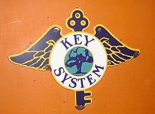
The Key System was a privately owned company that provided mass transit in the cities of Oakland, Berkeley, Alameda, Emeryville, Piedmont, San Leandro, Richmond, Albany, and El Cerrito in the eastern San Francisco Bay Area from 1903 until 1960, when it was sold to a newly formed public agency, AC Transit. The Key System consisted of local streetcar and bus lines in the East Bay, and commuter rail and bus lines connecting the East Bay to San Francisco by a ferry pier on San Francisco Bay, later via the lower deck of the Bay Bridge. At its height during the 1940s, the Key System had over 66 miles (106 km) of track. The local streetcars were discontinued in 1948 and the commuter trains to San Francisco were discontinued in 1958. The Key System's territory is today served by BART and AC Transit bus service.

Embarcadero station is a combined BART and Muni Metro rapid transit subway station in the Market Street subway in downtown San Francisco. Located under Market Street between Drumm Street and Beale Street near The Embarcadero, it serves the Financial District neighborhood and surrounding areas. The three-level station has a large fare mezzanine level, with separate platform levels for Muni Metro and BART below. Embarcadero station opened in May 1976 – almost two years after service began through the Transbay Tube – as an infill station.

The San Francisco Ferry Building is a terminal for ferries that travel across the San Francisco Bay, a food hall and an office building. It is located on The Embarcadero in San Francisco, California and is served by Golden Gate Ferry and San Francisco Bay Ferry routes.
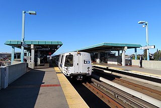
West Oakland station is a Bay Area Rapid Transit (BART) station in the West Oakland neighborhood of Oakland, California. It has two elevated side platforms, and is located near the eastern end of the Transbay Tube. All main BART lines except the Orange Line stop at the station. The Oakland Wye is located to the east of the station.

19th Street Oakland station is an underground Bay Area Rapid Transit (BART) station located under Broadway between 17th Street and 20th Street in the Uptown District of Oakland, California. It is a timed transfer point between northbound trains to Richmond and to Antioch. It is the busiest BART station in both Oakland and the East Bay, and the 5th busiest BART station overall, with a daily ridership of approximately 4,700 in September 2023.

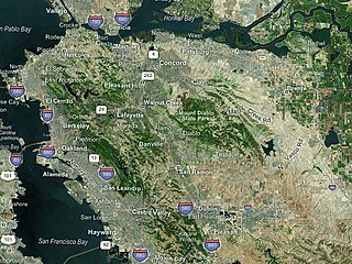
People in the San Francisco Bay Area rely on a complex multimodal transportation infrastructure consisting of roads, bridges, highways, rail, tunnels, airports, seaports, and bike and pedestrian paths. The development, maintenance, and operation of these different modes of transportation are overseen by various agencies, including the California Department of Transportation (Caltrans), the Association of Bay Area Governments, San Francisco Municipal Transportation Agency, and the Metropolitan Transportation Commission. These and other organizations collectively manage several interstate highways and state routes, eight passenger rail networks, eight trans-bay bridges, transbay ferry service, local and transbay bus service, three international airports, and an extensive network of roads, tunnels, and bike paths.
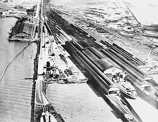
The Oakland Long Wharf was an 11,000-foot railroad wharf and ferry pier along the east shore of San Francisco Bay located at the foot of Seventh Street in West Oakland. The Oakland Long Wharf was built, beginning 1868, by the Central Pacific Railroad on what was previously Oakland Point. Beginning November 8, 1869, it served as the west coast terminus of the First transcontinental railroad. In the 1880s, Southern Pacific Railroad took over the CPRR, extending it and creating a new ferry terminal building with the official station name Oakland Pier. The entire structure became commonly and popularly called the Oakland Mole. Portions of the Wharf lasted until the 1960s. The site is now part of the facilities of the Port of Oakland, while passenger train service operates at the nearby Jack London Square/Dellums Station and another nearby station in Emeryville.

The station complex of Amtrak's Oakland Coliseum station and Bay Area Rapid Transit (BART)'s Coliseum station is located in the East Oakland area of Oakland, California, United States. The two stations, located about 600 feet (180 m) apart, are connected to each other and to the Oakland Coliseum/Oakland Arena sports complex with an accessible pedestrian bridge.

San Francisco Bay in California has been served by ferries of all types for over 150 years. John Reed established a sailboat ferry service in 1826. Although the construction of the Golden Gate Bridge and the San Francisco–Oakland Bay Bridge led to the decline in the importance of most ferries, some are still in use today for both commuters and tourists.
The San Francisco Transbay development is a completed redevelopment plan for the neighborhood surrounding the Transbay Transit Center site, South of Market near the Financial District in San Francisco, California. The new transit center replaced the since-demolished San Francisco Transbay Terminal, and new skyscrapers, such as Salesforce Tower, took advantage of the height increases allowed through the San Francisco Transit Center District Plan. The sale of several land parcels formerly owned by the state and given to the managing Transbay Joint Powers Authority helped finance the construction of the transit center.

Downtown Oakland is the central business district of Oakland, California, United States. It is located roughly bounded by both the Oakland Estuary and Interstate 880 on the southwest, Interstate 980 on the northwest, Grand Avenue on the northeast, and Lake Merritt on the east.

San Francisco Bay Ferry is a public transit passenger ferry service in the San Francisco Bay, administered by the San Francisco Bay Area Water Emergency Transportation Authority (WETA) and operated under contract by the privately owned, Blue and Gold Fleet. In 2022, the system had a ridership of 1,787,400, or about 9,400 per weekday as of the second quarter of 2023.
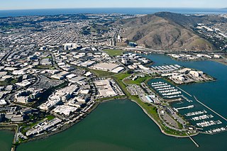
Oyster Point Marina/Park is a 408-berth public marina and 33-acre (13 ha) park located in the city of South San Francisco, California on the western shoreline of San Francisco Bay.

The Transbay Transit Center is a transit station in downtown San Francisco. It serves as the primary bus terminal—and potentially as a future rail terminal—for the San Francisco Bay Area. The centerpiece of the San Francisco Transbay development, the construction is governed by the Transbay Joint Powers Authority (TJPA). The 1,430-foot-long (440 m) building is located one block south-east of Market Street, a primary commercial and transportation artery in San Francisco.

The Oakland Ferry Terminal is a ferry terminal on the San Francisco Bay, located in Jack London Square in Oakland, California.

The South San Francisco Ferry Terminal is the only operating ferry terminal in San Mateo County, California. Boats are operated there by the San Francisco Bay Ferry company, and connect the city of South San Francisco to the Oakland Ferry Terminal in Jack London Square as well as Alameda, California.


