
Alameda is a city in Alameda County, California, located in the East Bay region of the Bay Area. The city is primarily located on Alameda Island, but also spans Bay Farm Island and Coast Guard Island, as well as a few other smaller islands in San Francisco Bay. As of the 2020 census, the city's population was 78,280.

San Francisco Bay is a large tidal estuary in the U.S. state of California, and gives its name to the San Francisco Bay Area. It is dominated by the cities of San Francisco, San Jose, and Oakland.
An alameda is a street or path lined with trees and may refer to:

San Diego Bay is a natural harbor and deepwater port located in San Diego County, California near the U.S.–Mexico border. The bay, which is 12 miles (19 km) long and 1 to 3 miles wide, is the third largest of the three large, protected natural bays on California's 840 miles (1,350 km) of coastline, after San Francisco Bay and Humboldt Bay. The highly urbanized land adjacent to the bay includes the city of San Diego and four other cities: National City, Chula Vista, Imperial Beach and Coronado.

State Route 61 is a state highway in the U.S. state of California, running along the eastern edge of Oakland International Airport and through Alameda. Two additional "hidden" state highways, State Route 112 and State Route 260, are also signed as part of SR 61, despite having legal descriptions separate from Route 61.

Coast Guard Base Alameda also referred to as Coast Guard Island is an artificial island in the Oakland Estuary between Oakland and Alameda, California. It is home to several major United States Coast Guard commands and cutters, including the Coast Guard Pacific Area. It is one of the largest Coast Guard bases on the West Coast. From 1942 until 1982, the island was the site of the Coast Guard's recruiting training center, enlisting and training hundreds of thousands of Coast Guardsmen including many of the 214,239 who served in the Pacific and European Theaters of World War II.

The East Bay Electric Lines were a unit of the Southern Pacific Railroad that operated electric interurban-type trains in the East Bay region of the San Francisco Bay Area. Beginning in 1862, the SP and its predecessors operated local steam-drawn ferry-train passenger service in the East Bay on an expanding system of lines, but in 1902 the Key System started a competing system of electric lines and ferries. The SP then drew up plans to expand and electrify its system of lines and this new service began in 1911. The trains served the cities of Berkeley, Albany, Emeryville, Oakland, Alameda, and San Leandro transporting commuters to and from the large Oakland Pier and SP Alameda Pier. A fleet of ferry boats ran between these piers and the docks of the Ferry Building on the San Francisco Embarcadero.

Temescal Creek is one of the principal watercourses in the city of Oakland, California, United States.
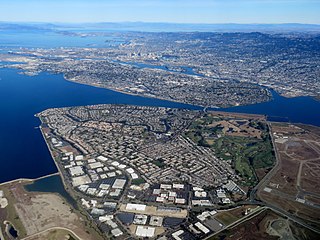
Bay Farm Island is a district of the city of Alameda, California, though it is separated from the rest of the city on Alameda Island by an estuary of San Leandro Bay. Its ZIP code is 94502. The location was originally an island in San Francisco Bay, but due to land reclamation it has become a peninsula and is now connected to the mainland of Oakland and Oakland International Airport. Marshes and other areas of the island were also reclaimed.
The Posey and Webster Street Tubes are two parallel underwater tunnels connecting the cities of Oakland and Alameda, California, running beneath the Oakland Estuary. Both are immersed tubes, constructed by sinking precast concrete segments to a trench in the Estuary floor, then sealing them together to create a tunnel. The Posey Tube, completed in 1928, currently carries one-way (Oakland-bound) traffic under the Estuary, while the Webster Street Tube, completed in 1963, carries traffic from Oakland to Alameda.

The Oakland Estuary is the strait in the San Francisco Bay Area, California, separating the cities of Oakland and Alameda and the Alameda Island from the East Bay mainland. On its western end, it connects to San Francisco Bay proper, while its eastern end connects to San Leandro Bay.

San Francisco Bay in California has been served by ferries of all types for over 150 years. John Reed established a sailboat ferry service in 1826. Although the construction of the Golden Gate Bridge and the San Francisco–Oakland Bay Bridge led to the decline in the importance of most ferries, some are still in use today for both commuters and tourists.
Sausal Creek, 3.1 miles (5.0 km) long, is one of the principal creeks in Oakland, California.

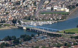
The Park Street Bridge is a double-leaf bascule drawbridge spanning 372 feet of the Oakland Estuary in the San Francisco Bay Area. It links the cities of Oakland and Alameda. In a year, the bridge is opened approximately 1700 times and carries approximately 40,000 vehicles per work day. It was built when the Oakland Estuary was trenched, converting Alameda from a peninsula to an island.

The Alameda Mole was a transit and transportation facility in Alameda, California for ferries landing in the East Bay of San Francisco from 1878 to the 1930s. It was located on the west end of Alameda, and later became part of the Alameda Naval Air Station. It was one of four neighbouring moles. The others were the Oakland Mole, the WP Mole, and the Key System Mole. The purpose of the mole was to extend tracks of rail-based transportation lines beyond the shallow mud flats along the shore of the East Bay into water deep enough to accommodate the passenger and rail ferries to San Francisco.
The San Francisco and Alameda Railroad (SF&A) was a short-lived railroad company in the East Bay area of the San Francisco Bay Area. The railroad line opened 1864–1865 from Alameda Terminal on Alameda Island to Hayward, California, with ferry service between Alameda Terminal and San Francisco started in 1864. After being bankrupted by the 1868 Hayward earthquake, it was acquired by a subsidiary of the Central Pacific Railroad in August 1869. Part of the SF&A line between Alameda Terminal and San Leandro served as a portion of the First transcontinental railroad starting in September 1869, while the southern section was abandoned in 1873.

The Oakland Ferry Terminal is a ferry terminal on the San Francisco Bay, located in Jack London Square in Oakland, California.

The High Street Bridge is a double-leaf bascule drawbridge spanning 296 feet of the Oakland Estuary in the San Francisco Bay Area, California, United States. It links the cities of Oakland and Alameda. The bridge is opened approximately 1,400 times a year. The bridge carries an average of 26,000 vehicles per year. The bridge was built when the Oakland Estuary was trenched, converting Alameda from a peninsula to an island.

The history of Oakland, a city in the county of Alameda, California, can be traced back to the founding of a settlement by Horace Carpentier, Edson Adams, and Andrew Moon in the 19th century. The area now known as Oakland had seen human occupation for thousands of years, but significant growth in the settlements that are now incorporated into the city did not occur until the Industrial Revolution. Oakland was first incorporated as a town in 1852.
The San Leandro Bay Bridge, better known as the Bay Farm Island Bridge, is a single-leaf bascule drawbridge spanning the San Leandro Channel, the inlet of San Leandro Bay within the San Francisco Bay Area, California, United States. It carries California State Route 61 and links the main island of Alameda with Bay Farm Island within the city of Alameda. The present bridge was completed in 1953; it is paralleled by a second bridge devoted to pedestrian and bicycle traffic, the Bay Farm Island Bicycle Bridge.


