
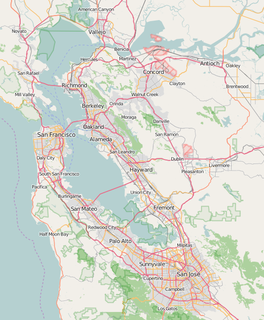
San Francisco Bay is a shallow estuary in the US state of California. It is surrounded by a contiguous region known as the San Francisco Bay Area, and is dominated by the large cities of San Jose, San Francisco and Oakland.

Suisun Bay is a shallow tidal estuary in northern California. It lies at the confluence of the Sacramento River and San Joaquin River, forming the entrance to the Sacramento–San Joaquin River Delta, an inverted river delta. Suisun Marsh, the tidal marsh land to the north, is the largest marsh in California. Grizzly Bay forms a northern extension of Suisun Bay. Suisun Bay is directly north of Contra Costa County.

The Sacramento–San Joaquin River Delta, or California Delta, is an expansive inland river delta and estuary in Northern California. The Delta is formed at the western edge of the Central Valley by the confluence of the Sacramento and San Joaquin rivers and lies just east of where the rivers enter Suisun Bay. The Delta is recognized for protection by the California Bays and Estuaries Policy. Sacramento–San Joaquin Delta was designated a National Heritage Area on March 12, 2019. The city of Stockton is located on the San Joaquin River on the eastern edge of the delta. The total area of the Delta, including both land and water, is about 1,100 square miles (2,800 km2). Its population is around 500,000 residents.
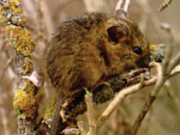
The salt marsh harvest mouse, also known as the red-bellied harvest mouse and sometimes called the saltmarsh harvest mouse, is an endangered rodent endemic to the San Francisco Bay Area salt marshes in CA. There are two distinct subspecies, both endangered and listed together on federal and state endangered species lists. The northern subspecies is lighter in color and inhabits the northern marshes of the bay, and the southern subspecies lives in the East and South Bay marshes. They are both quite similar in appearance to their congener species, the [Western harvest mouse, R. megalotis], to which they are not closely related. Genetic studies of the northern subspecies have revealed that the salt marsh harvest mouse is most closely related to the plains harvest mouse, R. montanus,, which occurs now in the Midwest]. Its endangered designation is due to its limited range, historic decline in population and continuing threat of habitat loss due to development encroachment at the perimeter of San Francisco Bay.
The Suisunes were a tribe of Native Americans that lived in Northern California's Suisun Marsh regions of Solano County, California between what is now Suisun City, Vacaville and Putah Creek around 200 years ago. The Suisunes' main village, Yulyul, is believed to be where Rockville, California is located today. Father Abella, visitor to the tribe in 1811, indicated they resided in the present location of Fairfield, north of the Suisun Bay. One of the Suisunes' primary food sources was acorns. Their diet also included fish as well as miner's lettuce. Their huts were conical wikiups made of rushes or tule thatch.

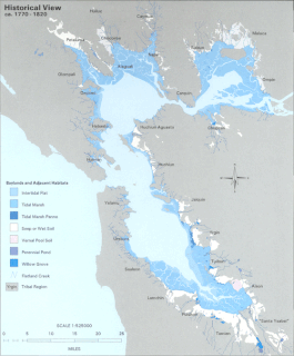
Located in northern California the Suisun Marsh has been referred to as the largest brackish water marsh on west coast of the United States of America. The marsh land is part of the San Francisco Bay tidal estuary, and subject to tidal ebb and flood. The marsh is home to many species of birds and other wildlife, and is formed by the confluence of the Sacramento and San Joaquin rivers between Martinez and Suisun City, California and several other smaller, local watersheds. Adjacent to Suisun Bay, the marsh is immediately west of the legally defined Sacramento-San Joaquin Delta as well as part of the San Francisco Bay estuary.

Cordelia is an unincorporated community in Solano County, California, United States. Cordelia is located along Interstate 80 and at the northern end of Interstate 680, 7 miles (11 km) west of Fairfield.

The splittail, also called Sacramento splittail, is a cyprinid fish native to the low-elevation waters of the Central Valley in California. It was first described by William O. Ayres in 1854. It is the sole living member of its genus, the Clear Lake splittail P. ciscoides having become extinct in the 1970s.

Sorex ornatus sinuosus, the Suisun shrew or Suisun ornate shrew, is a subspecies of the ornate shrew that occurs in the tidal marshes of the northern shores of San Pablo and Suisun bays. Brown and Rudd redefined the western boundary of the range from a prior designation of the Petaluma River. The Suisun shrew has been designated as a Species of Concern by the U.S. government and a Mammalian Species of Special Concern by the state of California.
Seal Slough is a narrow winding tidal channel through a tidal marsh in San Mateo and Foster City, California. This slough has been the object of a wetland restoration project in recent years to enhance habitat value. Dredging has been carried out in Seal Slough since at least 1954. When the original sewage treatment plant for the city of San Mateo was constructed in 1935, its discharge was directed to Seal Slough.
Cordelia Slough is a 10.8-mile-long (17.4 km) tidal watercourse which discharges to the Suisun Slough, which in turn empties into Grizzly Bay in Solano County, California. The Suisun Slough, fed by the Green River and Red Top Creek, provides a productive habitat for a diversity of aquatic flora and fauna. In particular steelhead migrate up Cordelia Slough to spawn in its two tributaries.
Mowry Slough is a 5.8-mile-long (9.3 km) slough in Don Edwards San Francisco Bay National Wildlife Refuge and is the primary breeding ground for San Francisco Bay harbor seals. It is situated among the salt marshes and salt evaporation ponds in the city of Fremont.
The Hydrography of the San Francisco Bay Area is a complex network of watersheds, marshes, rivers, creeks, reservoirs, and bays predominantly draining into the San Francisco Bay and Pacific Ocean.

Browns Island is a regional preserve of the East Bay Regional Park District (EBRPD) in Pittsburg, Contra Costa County, California, United States. It is an island in Suisun Bay, part of the Sacramento-San Joaquin River Delta, separated from Pittsburg by New York Slough. The 595-acre (241 ha) island is separated from Winter Island to the east by Middle Slough, and bounded by New York Slough on the south and Suisun Bay on the west and northwest. The East Bay Regional Park District has published a guide to the wild plants that grow on this island.

The San Francisco Bay National Estuarine Research Reserve is one of 27 reserves established as part of the United States National Estuarine Research Reserve System. The reserve is used to promote San Francisco Bay wetlands and estuary research, education, and stewardship.
Georgiana Slough, is a slough within Sacramento County, California. It is located in the Sacramento–San Joaquin River Delta, and links both the Sacramento River and the San Joaquin River above their confluence in the Delta near Pittsburg, at the head of Suisun Bay, through its connection with the Mokelumne River. The entrance to the slough on the Sacramento River is just below Walnut Grove, at 38°14′21″N121°30′59″W and runs between Tyler Island and Andrus Island to where it has its confluence with the Mokelumne River at 38°07′49″N121°34′40″W northwest of Bouldin Island just above that rivers confluence with the San Joaquin River.
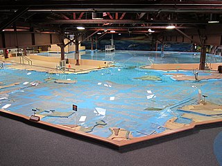
The U.S. Army Corps of Engineers Bay Model is a working hydraulic scale model of the San Francisco Bay and Sacramento-San Joaquin River Delta System. While the Bay Model is still operational, it is no longer used for scientific research but is instead open to the public alongside educational exhibits about Bay hydrology. The model is located in the Bay Model Visitor Center at 2100 Bridgeway Blvd. in Sausalito, California.

Stockton Deepwater Shipping Channel also called the Baldwin-Stockton Deepwater Shipping Channel or Stockton Deep Water Channel is a manmade deepwater water channel that runs from Suisun Bay and the Sacramento River - Sacramento Deep Water Ship Channel to the Port of Stockton and the Stockton Channel in California. The Stockton Ship Channel is 41 mi (66 km) long and about 37 ft (11 m) deep, allowing up to Panama Canal size ocean ships access to the Port of Stockton at the City of Stockton. The Stockton Deepwater Shipping Channel is part of the vast Sacramento–San Joaquin River Delta that has a connection to the Pacific Ocean. Stockton Deepwater Shipping Channel is also called the lower San Joaquin River.


