
Barretos is a municipality in the northern part of the state of São Paulo, Brazil. The city has approximately 122,833 inhabitants (IBGE/2020) and an area of 1566.1 km². Barretos belongs to the Mesoregion of Ribeirão Preto.

Piauí is one of the states of Brazil, located in the country's Northeast Region. The state has 1.6% of the Brazilian population and produces 0.7% of the Brazilian GDP.

Gramado is a small tourist city, southeast of Caxias do Sul and east of Nova Petrópolis in the southern Brazilian state of Rio Grande do Sul, in the Serra Gaúcha region. The city was originally settled by Azorean descendants and later received a contingent of German and Italian immigrants. Gramado is one of the cities along the scenic route known as Rota Romântica.
Alumínio is a Brazilian municipality of the state of São Paulo. It is part of the Metropolitan Region of Sorocaba. The population is 18,767 in an area of 83.66 km2. The elevation is 790 m. Alumínio is located east of Sorocaba and is also a suburban area. The main employer in Alumínio is Companhia Brasileira de Aluminio.

Santo Antônio dos Milagres is a municipality in the western part of the state of Piauí, Brazil. The population is 2,166 in an area of 33.15 km².

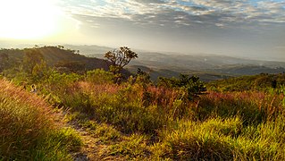
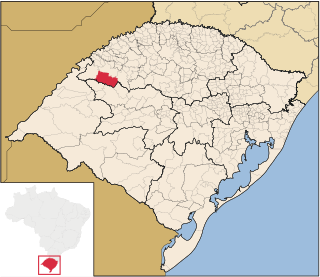
Caibaté is a municipality of the state of Rio Grande do Sul, Brazil. The population is 4,823 in an area of 259.66 km². The name comes from the Tupi language. It is located 524 km west of the state capital of Porto Alegre, northeast of Alegrete.
Bossoroca is a municipality of the western part of the state of Rio Grande do Sul, Brazil. The population is 6,205 in an area of 1610.57 km². The name comes from the Guarani language, and may mean erosion. It is located 524 km west of the state capital of Porto Alegre, northeast of Alegrete.

Catuípe is a municipality of the western part of the state of Rio Grande do Sul, Brazil. The population is 8,701 in an area of 583.26 km². Its nickname is Land of Spring Water for the springs located around the municipality. It is located 419 km west of the state capital of Porto Alegre, northeast of Alegrete.
Ubiretama is a municipality of the western part of the state of Rio Grande do Sul, Brazil. The name comes from the Tupi language. It is located 499 km west of the state capital of Porto Alegre, northeast of Alegrete and east of Argentina. The population is 1,983 in an area of 126.69 km2.
Following are the official winners of the national Brazilian Chess Championships from 1927 to date.

Capão do Leão is a Brazilian municipality in the southern part of the state of Rio Grande do Sul. The population is 25,409 in an area of 785.37 km². The city hosts the main campus of Universidade Federal de Pelotas, the largest higher education institution in the southern portion of Rio Grande do Sul.
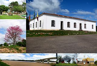
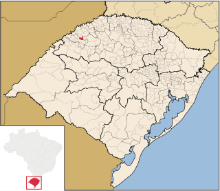
Cristal is a Brazilian municipality in the southeastern part of the state of Rio Grande do Sul. The population is 8,067 in an area of 681.63 km². The Camaquã River flows through the municipality.

Miraí is a Brazilian municipality located in the state of Minas Gerais. The city belongs to the mesoregion of Zona da Mata and to the microregion of Muriaé.

Amaral Ferrador is a municipality in the state of Rio Grande do Sul, Brazil. The population is 7,085 in an area of 506.46 km². It is situated on the Camaquã River.

Durandé is a Brazilian municipality located in the state of Minas Gerais. The city belongs to the mesoregion of Zona da Mata and to the microregion of Manhuaçu. Districts within the county are St. John Figueira and São José da Figueira.
The Federal University of Sergipe is a Brazilian public institution based in Sergipe, with campuses in São Cristóvão, Aracaju, Itabaiana, Laranjeiras, and Lagarto. Founded in 1967 by the junction of the state's existing colleges, it became its second university and its first public one. It became the state's most reputable and disputed higher education institution, ranking among the country's 40 best universities and Latin America's top 200 list.
El Harino is a corregimiento in La Pintada District, Coclé Province, Panama. It has a land area of 252.1 square kilometres (97.3 sq mi) and had a population of 5,455 as of 2010, giving it a population density of 21.6 inhabitants per square kilometre (56/sq mi). Its population as of 1990 was 6,520; its population as of 2000 was 6,990.
El Potrero is a corregimiento in La Pintada District, Coclé Province, Panama. It has a land area of 73.9 square kilometres (28.5 sq mi) and had a population of 3,165 as of 2010, giving it a population density of 42.8 inhabitants per square kilometre (111/sq mi). Its population as of 1990 was 2,672; its population as of 2000 was 2,815.
The case of the three jaguars was a case involving the killings of three jaguars in Cáceres, Mato Grosso, Brazil.


