Petrópolis, also known as The Imperial City, is a municipality in the Southeast Region of Brazil. It is located in the state of Rio de Janeiro, 68 kilometres (42 mi) northeast of the city of Rio de Janeiro. According to the 2010 National Brazilian Census, Petrópolis municipality had 295,917 inhabitants that year, up from 286,537 inhabitants at the last census. Besides being the largest and most populous city in the Fluminense Mountain Region, the city also has the largest GDP and HDI in the region.
Cunha is a municipality in the state of São Paulo in Brazil. It is part of the Metropolitan Region of Vale do Paraíba e Litoral Norte. The population is 21,459 in an area of 1,407.25 km². The first inhabitants arrived in the beginning of the 18th century. The municipality was founded in 1785, it was elevated to a city in 1858. Since 1975 Cunha has become an important center of stoneware ceramics, with 5 Noborigama wood fired kilns and 16 ceramics studios in all. The city is visited for ceramics, a pleasant climate, natural parks and gastronomy. In recent years tourism to the region has grown, with visitors coming from around the region to enjoy the local state park, artisan shops such as Aracatu and Oficina da Lã as well as festivals like the annual lamb festival. On October 25, 2015, Cunha hosted the first edition of the Brazilian portion of the Tour de France cycling competition.

Santo Amaro, also known as Santo Amaro da Purificação, is a municipality in the state of Bahia in Brazil. The population is 60,131 in an area of 492.9 square kilometres (190.3 sq mi). It is located in the metropolitan area of Salvador. Santo Amaro is located approximately 73 kilometres (45 mi) from the city of Salvador. Santo Amaro was home to numerous indigenous peoples until the arrival of the Portuguese, who developed the region for sugarcane production. Santo Amaro is now noted for its numerous historic structures. The city is also a center of Candomblé, having more than 60 terreiros, or temples of the religion.
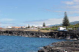
Santo António is a civil parish in the municipality of São Roque do Pico on the northern coast of the island of Pico in the Portuguese archipelago of the Azores. The population in 2011 was 815 in an area of approximately 32.03 square kilometres (12.37 sq mi).

Feira de Santana is a city in Bahia, Brazil. It is the second-most populous city in the state, with a population of 619,609 according to IBGE's estimate in 2020. It is located 100 km northwest of Salvador, Bahia's capital city. These cities are connected by BR-324, a four-lane divided highway.
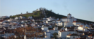
Aljustrel is a town and a municipality in the Portuguese district of Beja. The population in 2011 was 9,257, in an area of 458.47 km2. The present mayor is Nelson Domingos Brito, elected by the Socialist Party. The municipal holiday is June 13.

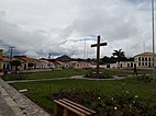
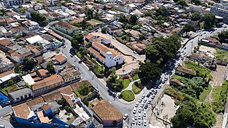
São Cristóvão is a Brazilian municipality in the Northeastern state of Sergipe. Founded at the mouth of the Vaza-Barris River on January 1, 1590, the municipality is the fourth oldest settlement in Brazil. São Cristóvão is noted for its historic city square, São Francisco Square, and numerous early colonial-period buildings. The 3 hectares site was designated a UNESCO World Heritage Site in 2010.

Raul d'Ávila Pompeia was a Brazilian novelist, short story writer and chronicler. He is famous for the Impressionist romance O Ateneu.

Cachoeira is an inland municipality of Bahia, Brazil, on the Paraguaçu River. The town exports sugar, cotton, and tobacco and is a thriving commercial and industrial centre.

Muriaé is a municipality in southeast Minas Gerais state, Brazil. It is located in the Zona da Mata region and its population in 2020 (IBGE) was approximately 109,392 inhabitants.
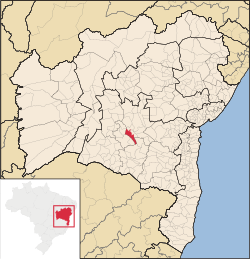
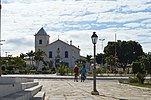
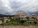
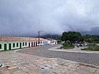
Caetité is a Brazilian municipality in the state of Bahia. It is located in the semi-arid sertão region in the interior of the state. It had an estimated 51,081 inhabitants as of 2020. It covers 2,651.5 square kilometres (1,023.7 sq mi) and is 757 kilometres (470 mi) from the state capital, Salvador. Caetité borders on ten other municipalities, all within Bahia: Igaporã, Guanambi, Pindaí, Licínio de Almeida, Caculé, Ibiassucê, Lagoa Real, Livramento do Brumado, Paramirim, and Tanque Novo.
Sabará is a Brazilian municipality located in the state of Minas Gerais. The city belongs to the Belo Horizonte metropolitan region and to the associated microregion.

Caçapava do Sul is a Brazilian municipality in the state of Rio Grande do Sul, located on the banks of the Camaquã River. As of 2020, the city has an estimated population of 33,548. It was the 2nd capital of the Piratini Republic from 1839 to 1840.

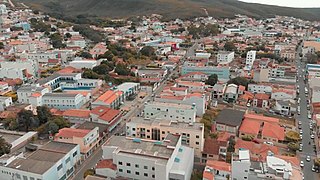
Jacobina is a city in the Centro Norte Baiano mesoregion of Bahia. It was founded July 28, 1722 and the population is 80,635. The town is surrounded by mountains, hills, lakes, rivers, springs, and waterfalls. Located in the northwest region of Bahia, in the extreme north of the Chapada Diamantina, Jacobina is 330 kilometers from Salvador and is also known as 'City of Gold', a legacy of the gold mines which attracted the pioneers from São Paulo in the early seventeenth century.

São Francisco do Conde is a municipality in the state of Bahia in the North-East region of Brazil. São Francisco do Conde covers 262.856 km2 (101.489 sq mi), and has a population of 40,245 with a population density of 150 inhabitants per square kilometer. It is located 67 kilometres (42 mi) from the state capital of Salvador. According to the Brazilian Institute of Geography and Statistics São Francisco do Conde has the highest concentration of Brazilians of African descent (90%) in Bahia.

Cairu is a municipality in the state of Bahia in the North-East region of Brazil. The municipality has a population of 18,427 with a population density of 33.3 inhabitants per square kilometer. The municipality consists of three islands: the Island of Cairu, which is only separated from the mainland by a narrow river; Tinharé Island, which has the dense tourist settlement of Morro de São Paulo to the north; and Boipeba Island.
Nazaré is a neighborhood in the city of Salvador, Bahia, Brazil. The region of present-day Nazaré was chiefly rural until the 19th century. It developed below the Historic Center of the city around the freguesias, or historical settlements of São Pedro, Santana do Sacramento, and later, Nossa Senhora de Brotas. Avenida Joana Angélica, a broad avenue, crosses the neighborhood from north-east to south-west. The avenue is named for Joana Angélica, a Brazilian Conceptionist nun and martyr of Brazilian Independence. Joana Angélica was stabbed by a bayonet at the Convent of Lapa by Portuguese colonial troops. Nazaré is home to numerous historic structures of the city; it is additionally home of several government and academic centers.

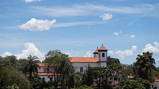
The Church of Our Lady of Santana is an 18th-century church in Rio de Contas, Bahia, Brazil. It is dedicated to Saint Anne. It dates to the first half of the 18th century, but construction on the structure ended around 1850s. It left the church with a unique appearance of red stone masonry without plaster on the exterior or interior. The façade of the church collapsed in the 1940s due to strong rain, and was reconstructed 6.2 metres (20 ft) back from the original to allow for the placement of supports. The church covers 420 square metres (4,500 sq ft) and is set back from the road and the nearby houses. It has a stone church stair that leads to a broad churchyard. The church is part of the Historic Center of Rio de Contas. The church is listed as a federal historic structure as part of the National Institute of Historic and Artistic Heritage.

The Immediate Geographic Region of Conselheiro Lafaiete is one of the 10 immediate geographic regions in the Intermediate Geographic Region of Barbacena, one of the 70 immediate geographic regions in the Brazilian state of Minas Gerais and one of the 509 of Brazil, created by the National Institute of Geography and Statistics (IBGE) in 2017.