
Saint Ann is the largest parish in Jamaica. It is situated on the north coast of the island, in the county of Middlesex, roughly halfway between the eastern and western ends of the island. It is often called "the Garden Parish of Jamaica" on account of its natural floral beauty. Its capital is Saint Ann's Bay. Saint Ann comprises New Seville, the first Spanish settlement in Jamaica.

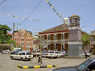
Ocho Rios is a town in the parish of Saint Ann on the north coast of Jamaica, and is more widely referred to as Ochi by locals. Beginning as a sleepy fishing village, Ocho Rios has seen explosive growth in recent decades to become a popular tourist destination featuring duty-free shopping, a cruise-ship terminal, world-renowned tourist attractions and several beaches and acclaimed resorts. In addition to being a port of call for cruise ships, Ocho Rios also hosts cargo ships at the Reynolds Pier for the exportation of sugar, limestone, and in the past, bauxite. The estimated population of the town in 2011 was 16,671, which is nearly 10% of the total population of St. Ann. The town is served by both Sangster International Airport and Ian Fleming International Airport. Scuba diving and other water sports are offered in the town's vicinity.

Saint Thomas, once known as Saint Thomas in the East, is a suburban parish situated at the south eastern end of Jamaica, within the county of Surrey. It is the birthplace of Paul Bogle, designated in 1969 as one of Jamaica's seven National Heroes. Morant Bay, its chief town and capital, is the site of the Morant Bay Rebellion in 1865, of which Bogle was a leader.

Saint Mary is a parish located in the northeast section of Jamaica. With a population of 114,227 it is one of Jamaica's smallest parishes, located in the county of Middlesex. Its chief town and capital is Port Maria, located on the coast. It is also the birthplace of established dancehall reggae artists, such as Capleton, Lady Saw, Ninjaman, Ini Kamoze, Sizzla, and Tanya Stephens. Other notable residents of St. Mary parish include bestselling author Colin Simpson, who is the great-great grandson of noted slavery abolitionist James Phillippo, famed Jamaican writer and community activist Erna Brodber, and acclaimed music producer Chris Blackwell who is credited with "discovering" Bob Marley.

Saint Elizabeth, one of Jamaica's largest parishes, is located in the southwest of the island, in the county of Cornwall. Its capital, Black River, is located at the mouth of the Black River, the widest on the island.

Clarendon is a parish in Jamaica. It is located on the south of the island, roughly halfway between the island's eastern and western ends. Located in the county of Middlesex, it is bordered by Manchester on the west, Saint Catherine in the east, and in the north by Saint Ann. Its capital and largest town is May Pen.
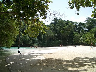
Boston Beach is a coastal community on the north coast of the island of Jamaica, with a public beach which is one of the few beaches in Jamaica attracting surfers. It is located nine miles east of the town of Port Antonio.

The Blue Mountains are the longest mountain range in Jamaica. They include the island's highest point, Blue Mountain Peak, at 2256 m (7402 ft). From the summit, accessible via a walking track, both the north and south coasts of the island can be seen. On a clear day, the outline of the island of Cuba, 210 km (130 mi) away, can also be seen. The mountain range spans four parishes: Portland, St. Thomas, St. Mary and St. Andrew.

Saint Andrew is a parish, situated in the southeast of Jamaica in the county of Surrey. It lies north, west and east of Kingston, and stretches into the Blue Mountains. As of the 2011 census, it had a population of 573,369, the highest of any of the parishes in Jamaica.
Port Antonio is the capital of the parish of Portland on the northeastern coast of Jamaica, about 100 km from Kingston. It had a population of 12,285 in 1982 and 13,246 in 1991. It is the island's third largest port, famous as a shipping point for bananas and coconuts, as well as one of its most important tourist attractions, tourism being a major contributor to the town's economy.
The First Maroon War was a conflict between the Jamaican Maroons and the colonial British authorities that started around 1728 and continued until the peace treaties of 1739 and 1740. It was led by self-liberated Africans who set up communities in the mountains. The name "Maroon" was given to these Africans, and for many years they fought the British colonial Government of Jamaica for their freedom. The maroons were very skilled, particularly in guerrilla warfare. It was followed about half a century later by the Second Maroon War.

Cornwall's rugged landscape and scenery have been used by film and television companies as a backdrop for some of their productions.
Frenchman's Cove Resort, previously known as Frenchman's Cove Hotel, is a hotel located on a 42-acre (170,000 m2) property near Port Antonio on Jamaica's northeastern shore. It is considered to be the world's first all-inclusive hotel with a history indicating its role in Jamaica's tourism industry.
Moore Town is a Maroon settlement located in the Blue Mountains and John Crow Mountains of Portland, Jamaica, accessible by road from Port Antonio. The easternmost Maroon town, Moore Town is located in the eastern end of the parish. Formerly known as New Nanny Town, Moore Town was founded in 1740 when the Peace Treaty was signed between the British colonial authorities and the Windward Maroons. This treaty allotted the Moore Town Maroons 1000 acres, but Moore Town only received 500. In 1781 the initial 500 acres was augmented with another 500 acres, taking their communal land up to 1,000 acres.
San San is a town in the parish of Portland in Jamaica.
Claverty Cottage is a small settlement located about 5 miles/8 km from Blue Mountain Peak in the parish of Portland, Jamaica. The population of this settlement is approximately 600 inhabitants. The district is known for its production of one of the most popular coffee brands in the island. Over the last several decades, this coffee has developed a reputation that has made it one of the most expensive and highly sought coffees in the world. In addition to its use for brewed coffee, the beans are the flavor base of Tia Maria coffee liqueur.

In early July 2005, Hurricane Dennis brushed Jamaica, bringing torrential rain and damaging floods to the island nation. Forming from a tropical depression on July 4, Dennis began impacting Jamaica three days later. Approximately 6,000 people evacuated from coastal and flood-prone areas prior to the storm's arrival while relief agencies allocated resources for recovery operations. Passing northeast of the island, impact from Dennis stemmed primarily from rainfall—accumulations peaked at 24.54 in (623 mm) and reached 1-in-50 year event levels. Widespread flooding and landslides damaged homes and isolated communities. Saint Thomas and Portland Parishes were hardest-hit; hundreds required evacuation as multiple rivers burst their banks.

Fort George is situated on the Titchfield Peninsula in the town of Port Antonio, in the parish of Portland, Jamaica. The proposal for a fort in Port Antonio was first discussed in 1728, when a committee of the House of Assembly met to consider measures to be taken in the face of a possible Spanish invasion. In 1729, Christian Lilly was assigned the task of building a fort which, after being built, became known as Fort George in honour of King George I of Great Britain. Lilly had built some of the walls at the Royal Citadel, Plymouth, and the bastion at Fort George was designed as a smaller version of the Citadel.

The 1944 Jamaica hurricane was a deadly major hurricane that swept across the Caribbean Sea and Gulf of Mexico in August 1944. Conservative estimates placed the storm's death toll at 116. The storm was already well-developed when it was first noted passing westward over the Windward Islands into the Caribbean Sea on August 16. A ship near Grenada with 74 occupants was lost, constituting a majority of the deaths associated with the storm. The following day, the storm intensified into a hurricane, reaching its peak strength on August 20 with maximum sustained winds of 120 mph (195 km/h). At this intensity, the major hurricane made landfall on Jamaica later that day, traversing the length of the island. The damage wrought was extensive, with the strong winds destroying 90 percent of banana trees and 41 percent of coconut trees in Jamaica; the overall damage toll was estimated at "several millions of dollars". The northern coast of Jamaica saw the most severe damage, with widespread structural damage and numerous homes destroyed across several parishes. In Port Maria, the storm was considered the worst since 1903.

