Saint Elizabeth Parish

Last updated

Saint Elizabeth
Saint Elizabeth in Jamaica.svg
Saint Elizabeth in Jamaica
Country Jamaica
County Cornwall
Capital Black River
Other towns Santa Cruz, Malvern, Junction,
Balaclava, Prospect, Southfield
Area
[1]
  Total1,212.4 km2 (468.1 sq mi)
  Rank2 [2]
Population
 (2012) [3]
  Total150,993
  Density120/km2 (320/sq mi)

Saint Elizabeth, one of Jamaica's largest parishes, is located in the southwest of the island, in the county of Cornwall. Its capital, Black River, is located at the mouth of the Black River, the widest on the island.

Contents

History

Saint Elizabeth originally included most of the southwest part of the island, but Westmoreland was taken from it in 1703, and in 1814 a part of Manchester. The resulting areas were named after the wife of Sir Thomas Modyford, the first English Governor of Jamaica.

There are archeological traces of Taíno/Arawak existence in the parish, as well as of 17th-century colonial Spanish settlements. After 1655, when the English settled on the island, they concentrated on developing large sugar cane plantations with enslaved African workers. Today, buildings with 'Spanish wall' construction (masonry of limestone sand and stone between wooden frames) can still be seen in some areas.

St Elizabeth became a prosperous parish, and Black River an important seaport. In addition to shipping sugar and molasses, Black River became the centre of the logging trade. Large quantities of logwood were exported to Europe to make a blue dye very like Prussian blue, which was very popular in the 18th and 19th centuries.

St Elizabeth was the first parish to have electric power, where it was first introduced in a house called Waterloo in Black River in 1893.

Geography

The parish is located at latitude 18°15'N, and longitude 77°56'W; to the west of Manchester, to the east of Westmoreland, and to the south of St. James and Trelawny. It covers an area of 1,212.4 km2, making it Jamaica's second-largest parish, smaller only than Saint Ann's 1,212.6 km2. The parish is divided into four electoral districts (constituencies), that is North-East, North-West, South-East and South-West.

Lovers' Leap, Saint Elizabeth Lovers' Leap.jpg
Lovers' Leap, Saint Elizabeth

The northern and northeastern parts of the parish are mountainous. There are three mountain ranges the Nassau Mountains to the north-east, the Lacovia Mountains to the west of the Nassau Mountains, and the Santa Cruz Mountains which, running south, divide the wide plain to end in a precipitous drop of 1,600 feet (490 m) at Lovers' Leap. The central and southern sections form an extensive plain divided by the Santa Cruz Mountains. A large part of the lowlands is covered by morass, but it still provides grazing land for horses and mules.

The main river in the parish is the Black River, and measuring 53.4 kilometres (33.2 mi), it is one of the longest rivers in Jamaica. It is navigable for about 40 kilometres (25 mi), and is supported by many tributaries including Y.S., Broad, Grass and Horse Savannah. The river has its source in the mountains of Manchester where it rises and flows west as the border between Manchester and Trelawny then goes underground. It reappears briefly in several surrounding towns, but reemerges near Balaclava and tumbles down gorges to the plain known as the Savannah, through the Great Morass and to the sea at Black River, the capital of the parish.

The geology of the parish is primarily alluvial plains to the south, and karstic limestone to the north. The karstic zones are known to contain over 130 caves (Jamaica Cave Register as of 2007 - from Fincham and JCO). These include Mexico Cave and Wallingford River Cave, near Balaclava, which are two associated sections of a major underground river that has its source in south Trelawny, as well as Yardley Chase Caves near the foot of Lovers' Leap, and Peru Cave, near Goshen, which has stalactites and stalagmites. Mineral deposits include bauxite, antimony, white limestone, clay, peat and silica sand, which is used to manufacture glass.

Demography

The parish had an estimated population of 148,000 in 2001, 4000 of whom live in the capital town. The distinct feature of this parish is that numerous ethnic groups can be found here; St Elizabeth probably has the greatest ethnic mixture in Jamaica. St. Elizabeth provides the best testimony of the Jamaican motto – "Out of many, one people". The Meskito (corrupted to ‘Mosquito’) Indians brought to Jamaica to help capture the Maroons, were allowed to settle in southern St. Elizabeth in return for their assistance and given land grants in this parish. This parish has also attracted Dutch, Spanish, Indian, Maroon, mulatto, English, and European inhabitants from the 17th century onwards, with the result that many observers feel that it has more people of mixed-race ancestry than can be found in any other part of the island.

In the 19th century Irish, Spanish, Portuguese, Scottish, Germans, Chinese, and East Indians migrated to Saint Elizabeth. There are pockets of ethnic concentrations in the parish, including Mulatto and Creole, notably found in the southeast.

Politics

Saint Elizabeth Parish has four MPs based in four constituencies: Saint Elizabeth North Eastern, Saint Elizabeth North Western, Saint Elizabeth South Eastern and Saint Elizabeth South Western.

Economy

Mining

The parish has been a major producer of bauxite since the 1960s. Port Kaiser, near a town called Alligator Pond, has a leading deep-water pier for bauxite export. The Alpart alumina refinery was constructed in the 1960s at Nain and produces nearly 2 million tonnes of alumina annually for export. The replacement cost of building the refinery is approximately $2 billion.

There are other alumina refineries close to the nearby town of Mandeville.

Agriculture

Apart from bauxite mining, the parish also produces a large quantity of Jamaica's sugar; there are two sugar factories in the parish. Fishing is a major industry in the parish, as is tomato canning; a plant is at Bull Savannah. The parish also cultivates crops such as cassava, corn, peas, beans, pimento, ginger, tobacco, tomato, rice sweet potatoes and coffee. As a result of the fertile soil that provide for grazing fields, pastoralism is possible. Livestock include goats, sheep, hogs, and cattle, horses.

Tourism

Since the 1990s, the parish has become a significant tourist destination, with most visitors going to the Treasure Beach area. The Appleton rum distillery, near the rough Cockpit Country in the north of the parish, is also a tourist destination. The Cockpit area was the site of Maroon settlements through much of the 18th century. Ecological tourism along the Black and YS rivers, and in the Great Morass, has been developed in recent years.

Education

The parish has 12 high schools and 75 primary level institutions as well as 167 early childhood institutions.[ citation needed ] Notable institutions include:

Places

Beaches

Towns and villages

The Social Development Commission's national grid of communities has sixty one communities in St. Elizabeth broken down into 465 districts. The communities which include major towns are:

  • Aberdeen
  • Accompong
  • Balaclava
  • Ballards Valley
  • Barbary Hall
  • Bigwoods
  • Black River
  • Braes River
  • Brinkley
  • Bogue
  • Brompton
  • Bull Savanna
  • Burnt Savannah
  • Carlisle
  • Carisbrook
  • Cotterwood
  • Crawford
  • Elderslie
  • Exton
  • Fairfield
  • Fullerswood
  • Goshen
  • Giddy Hall
  • Hodges
  • Holland
  • Hopewell
  • Junction
  • Lacovia
  • Leeds
  • Lititz
  • Maggotty
  • Malvern
  • Merrywood
  • Morningside
  • Mountainside
  • Middle Quarters
  • Mulgrave
  • Nain
  • Newell
  • Newton
  • Parrottee
  • Pepper
  • Pedro Plains
  • Pondside
  • Portsea
  • Potsdam
  • Quickstep
  • Red Bank
  • Rose Hall
  • Roses Valley
  • Rose Hall
  • Russells
  • Retirement
  • Santa Cruz
  • Southfield
  • Siloah
  • Springfield
  • Top Hill
  • Thornton
  • Treasure Beach
  • Watchwell
  • Warminster
  • White Hill

Flagaman

Caves

St. Elizabeth has approximately 44 caves, including:

Other places of interest

See also

Related Research Articles

<span class="mw-page-title-main">Geography of Jamaica</span> Geographical features of Jamaica

Jamaica lies 140 km (87 mi) south of Cuba and 190 km (118 mi) west of Haiti. At its greatest extent, Jamaica is 235 km (146 mi) long, and its width varies between 34 and 84 km. Jamaica has a small area of 10,992 km2 (4,244 sq mi). However, Jamaica is the largest island of the Commonwealth Caribbean and the third largest of the Greater Antilles, after Cuba and Hispaniola. Many small islands are located along the south coast of Jamaica, such as the Port Royal Cays. Southwest of mainland Jamaica lies Pedro Bank, an area of shallow seas, with a number of cays, extending generally east to west for over 160 km (99 mi). To the southeast lies Morant Bank, with the Morant Cays, 51 km (32 mi) from Morant Point, the easternmost point of mainland Jamaica. Alice Shoal, 260 km (160 mi) southwest of the main island of Jamaica, falls within the Jamaica–Colombia Joint Regime. It has an Exclusive Economic Zone of 258,137 km2 (99,667 sq mi).

<span class="mw-page-title-main">Economy of Jamaica</span> National economy

The economy of Jamaica is heavily reliant on services, accounting for 70% of the country's GDP. Jamaica has natural resources and a climate conducive to agriculture and tourism. The discovery of bauxite in the 1940s and the subsequent establishment of the bauxite-alumina industry shifted Jamaica's economy from sugar, and bananas.

<span class="mw-page-title-main">Saint Ann Parish</span> Parish of Jamaica

Saint Ann is the largest parish in Jamaica. It is situated on the north coast of the island, in the county of Middlesex, roughly halfway between the eastern and western ends of the island. It is often called "the Garden Parish of Jamaica" on account of its natural floral beauty. Its capital is Saint Ann's Bay. Saint Ann comprises New Seville, the first Spanish settlement in Jamaica.

<span class="mw-page-title-main">Ocho Rios</span> Town in Middlesex, Jamaica

Ocho Rios is a town in the parish of Saint Ann on the north coast of Jamaica, and is more widely referred to as Ochi by locals. Beginning as a sleepy fishing village, Ocho Rios has seen explosive growth in the last decade to become a popular tourist destination featuring duty-free shopping, a cruise-ship terminal, world-renowned tourist attractions and several beaches and acclaimed resorts. In addition to being a port of call for cruise ships, Ocho Rios also hosts cargo ships at the Reynolds Pier for the exportation of sugar, limestone, and in the past, bauxite. The estimated population of the town in 2011 was 16,671, which is nearly 10% of the total population of St. Ann. The town is served by both Sangster International Airport and Ian Fleming International Airport. Scuba diving and other water sports are offered in the town's vicinity.

<span class="mw-page-title-main">Saint Thomas Parish, Jamaica</span> Parish of Jamaica

Saint Thomas, once known as Saint Thomas in the East, is a suburban parish situated at the south eastern end of Jamaica, within the county of Surrey. It is the birthplace of Paul Bogle, designated in 1969 as one of Jamaica's seven National Heroes. Morant Bay, its chief town and capital, is the site of the Morant Bay Rebellion in 1865, of which Bogle was a leader.

<span class="mw-page-title-main">Saint Catherine Parish</span> Parish of Jamaica

Saint Catherine is a parish in the south east of Jamaica. It is located in the county of Middlesex, and is one of the island's largest and most economically valued parishes because of its many resources. It includes the first capital of Jamaica, Spanish Town, originally known as San Jago de la Vega or Santiago de la Vega.

<span class="mw-page-title-main">Westmoreland Parish</span> Parish of Jamaica

Westmoreland is the westernmost parish in Jamaica, located on the south side of the island. It is situated south of Hanover, southwest of Saint James, and northwest of Saint Elizabeth, in the county of Cornwall. The chief town and capital is Savanna-la-Mar. Negril, a famous tourist destination, is also situated in the parish.

<span class="mw-page-title-main">Clarendon Parish, Jamaica</span> Parish of Jamaica

Clarendon is a parish in Jamaica. It is located on the south of the island, roughly halfway between the island's eastern and western ends. Located in the county of Middlesex, it is bordered by Manchester on the west, Saint Catherine in the east, and in the north by Saint Ann. Its capital and largest town is May Pen.

<span class="mw-page-title-main">Black River, Jamaica</span> Parish Capital in St Elizabeth, Jamaica

Black River is the capital of St. Elizabeth Parish, in southwestern Jamaica. It developed as a port around the mouth of the river of the same name. Today, the city is a centre of environmental tourism and a gateway to the Treasure Beach resort area. Treasure Beach and Crane Beach are to the south-east, with Luana Beach to the west. In the 18th and early 19th centuries, it was a thriving sugar port with a market for African slaves.

<span class="mw-page-title-main">Trelawny Parish</span> Parish of Jamaica

Trelawny is a parish in the county of Cornwall in northwest Jamaica. Its capital is Falmouth. It is bordered by the parishes of Saint Ann in the east, Saint James in the west, and Saint Elizabeth and Manchester in the south. Trelawny is known for producing several Olympic sprinters.

<span class="mw-page-title-main">Saint James Parish, Jamaica</span> Parish of Jamaica

St. James is a suburban parish, located on the north-west end of the island of Jamaica in the county of Cornwall. Its capital is Montego Bay. Montego Bay was officially named the second city of Jamaica, behind Kingston, in 1981, although Montego Bay became a city in 1980 through an act of the Jamaican Parliament. The parish is the birthplace of the Right Excellent Samuel Sharpe, one of Jamaica's seven National Heroes.

<span class="mw-page-title-main">Manchester Parish</span> Parish of Jamaica

The Parish of Manchester is a parish located in west-central Jamaica, in the county of Middlesex. Its capital, Mandeville, is a major business centre. Its St. Paul of the Cross Pro-Cathedral is the episcopal see of the Latin Catholic Diocese of Mandeville.

Alcoa World Alumina and Chemicals is a joint venture between Alumina Limited and Alcoa and is abbreviated to AWAC. AWAC's business is the mining of bauxite, the extraction of alumina and the smelting of aluminium. It has about 25% of the global alumina market. Alcoa acts as the day-to-day manager.

<span class="mw-page-title-main">Black River (Jamaica)</span> River in Jamaica

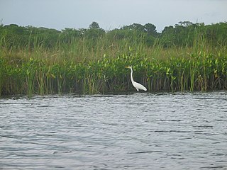
The Black River is one of the longest rivers in Jamaica. At a length of 53.4 km (33.2 mi), it was believed to be the longest until it was discovered that the Rio Minho was 92.8 km long. Its name refers to the darkness of the river bed caused by thick layers of decomposing vegetation. Over 100 species of birds have been recorded in the Black River morass.

<span class="mw-page-title-main">Discovery Bay, Jamaica</span>

Discovery Bay is a town in Saint Ann Parish on the northern coast of Jamaica. The city is also known locally as Dry Harbour, and gives its name to the Dry Harbour Mountains in St. Ann. There is a dispute as to whether Christopher Columbus first landed in Discovery Bay or Sevilla la Nueva in 1494. Near to the city are Puerto Seco Beach and several historic sites, such as the Green Grotto Caves and Columbus Park. Visitors to the Green Grotto Caves can see relics of the native Taíno Arawak lifestyle there. It is said that many Spaniards escaped the English invasion of 1655 through secret passages in the caves with the help of Arawaks and African slaves, in exchange for the slaves' freedom.

<span class="mw-page-title-main">Cockpit Country</span> Geographical Region in Trelawny, Jamaica

Cockpit Country is an area in Trelawny and Saint Elizabeth, Saint James, Saint Ann, Manchester and the northern tip of Clarendon parishes in Jamaica. The land is marked by steep-sided hollows, as much as 120 metres (390 ft) deep in places, which are separated by conical hills and ridges. Maroons who had escaped from plantations used the difficult territory for its natural defences to develop communities outside the control of Spanish or British colonists.

<span class="mw-page-title-main">Lacovia</span>

Lacovia is a town in Saint Elizabeth Parish, Jamaica, located on the Black River between the Upper Morass and the Lower Morass.

<span class="mw-page-title-main">Rio Bueno, Jamaica</span> Village in Jamaica

Rio Bueno is a settlement in Jamaica. It has a population of 1,096 as of 2009.

Nain Airstrip is an airstrip serving the town of Nain and the Alpart alumina refinery in the Saint Elizabeth Parish of Jamaica. The airstrip is 2 kilometres (1.2 mi) northwest of Nain.

References

Notes

  1. The title of largest parish in Jamaica has caused some confusion. The parishes of St. Catherine, Saint Elizabeth or St. Ann are usually ranked as the largest, depending on the source. The Gleaner, one of the nations most reputable newspapers, lists St. Catherine as the largest with an area of 1,260 sq km, St. Ann as the second largest with 1200 sq km, and St. Elizabeth third with 1,185 km² (Geography and History of Jamaica. The Jamaica Gleaner. Accessed 9 April 2009). However, The Jamaica Library Service database ranks St Ann the largest with an area of 1212.6 km² (Saint Ann Archived 4 December 2008 at the Wayback Machine . Jamaica Library Services. Accessed 9 April 2009), St. Elizabeth second with 1212.4 km² (St. Elizabeth Archived 4 December 2008 at the Wayback Machine . Jamaica Library Services. Accessed 9 April 2009), and St. Catherine third with 1192.4 km² (Saint Catherine Archived 4 December 2008 at the Wayback Machine . Jamaica Library Services. Accessed 9 April 2009).
  2. Saint Elizabeth Archived 4 December 2008 at the Wayback Machine . Jamaica Library Services. Accessed 9 April 2009
  3. "Population by Parish". Statistical Institute of Jamaica. Retrieved 16 September 2015.
  4. "About Lover's Leap". Archived from the original on 21 October 2009. Retrieved 25 October 2009.
  5. "Black River Lower Morass | Ramsar Sites Information Service". rsis.ramsar.org. Retrieved 10 October 2022.

Bibliography

18°03′N77°47′W / 18.050°N 77.783°W / 18.050; -77.783