Portskewett

Last updated

Portskewett
  • Welsh: Porthsgiwed / Porthysgewin
Portskewett.jpg
Monmouthshire UK location map.svg
Red pog.svg
Portskewett
Location within Monmouthshire
Population2,133 (2011) [1]
OS grid reference ST499881
Principal area
Preserved county
Country Wales
Sovereign state United Kingdom
Post town CALDICOT
Postcode district NP26
Dialling code 01291
Police Gwent
Fire South Wales
Ambulance Welsh
UK Parliament
List of places
UK
Wales
Monmouthshire
51°35′24″N2°43′30″W / 51.590°N 2.7251°W / 51.590; -2.7251

Portskewett (Welsh : Porthsgiwed or Porthysgewin) is a village and community (parish) in Monmouthshire, south east Wales. It is located four miles south west of Chepstow and one mile east of Caldicot, in an archaeologically sensitive part of the Caldicot Levels on the Welsh shore of the Severn Estuary. The Second Severn Crossing passes overhead carrying the M4 motorway. The community includes Sudbrook, Crick and Leechpool.

Contents

History and prehistory

Heston Brake puddingstones Heston-brake-2.jpg
Heston Brake puddingstones
Plan of chambered tumulus at Heston Brake, by Mary Ellen Bagnall Oakeley (1888) Plan of Chambered Tumulus at Heston Brake.jpg
Plan of chambered tumulus at Heston Brake, by Mary Ellen Bagnall Oakeley (1888)

Heston Brake

At the eastern edge of the village, in a privately owned field opposite Black Rock Road, very near to the Leechpool turn, is evidence of a significant neolithic chambered tomb or long barrow. A small group of puddingstones mark the entrance of the site known as Heston Brake. Human skeletons, cattle bones and some pottery were discovered in the chamber when it was excavated in 1888. [2]

The stones can be reached by following the public footpath accessed via the kissing gate which is situated on the left [3] about 150 metres (160 yd) from the main road toward Leechpool. In his 1954 Monmouthshire Sketch Book Hando writes: "Garn Llwyd, Gwern-y-Cleppa and Heston Brake are our three outstanding dolmens". [4]

Roman remains

There is some evidence of a Roman villa, with possible British Iron Age antecedents. There are also remains of a late Roman temple on Portskewett Hill, and many coins of the 3rd and 4th centuries have been found. [5]

Early Welsh history

The name Portskewett is generally believed to derive from the Welsh Porth-is-Coed, meaning "the harbour below the wood", or alternatively "the harbour of the area below the wood" - that is, the post-Roman cantref of Gwent Is Coed, centred on Caerwent about 3 miles away. [4] An alternative derivation is from Porth Ysgewydd, the port of the elder wood.

According to tradition, in about the 6th century Caradog Freichfras, king of Gwent, moved his llys or court from Caerwent to Portskewett, where there was a strongly flowing fresh water spring which only dried up later when the Severn Tunnel was built. Alternatively, the court may have been based at nearby Sudbrook. [6] [7]

Portskewett is mentioned in ancient Welsh stories as one of the three chief ports of Wales. A Welsh poem of around the 7th century, Moliant Cadwallon, describes it as "beautiful Porth Esgewin, the estuary on the border", and the medieval Welsh phrase meaning from one end of the country to another translates as "from Porth Wygyr to Portskewett". [6] The harbour later silted up. It is now a marshy area at Caldicot Pill, close to the Second Severn Crossing and industrial sites, and crossed by power cables and railway lines, including the entrance to the Severn Tunnel. Archaeological investigations have revealed wetland structures, including fish traps, with dates from the 6th century onwards. [5]

The tradition of "King Harold's Palace"

The uneven ground south of the village church is shown on some older maps as "Harold’s Field". According to the Anglo-Saxon Chronicle , in 1065 Earl Harold of Wessex, having defeated Gruffydd ap Llywelyn and conquered areas around Hereford and down the Wye, and was in the process of constructing a building on the site which he could use as a base for hunting when it was attacked and destroyed by a force under Caradog ap Gruffydd, King of Gwent. Harold never had the opportunity to take his revenge; in January 1066 he became king of England, and later that year was killed at the Battle of Hastings. [7] Archaeologists consider it likely that the hunting lodge would have been built on the same site as Caradog Freichfras' earlier court. [6]

A geophysical survey carried out at the end of 2005 revealed extensive remains in the area. In May 2007, an excavation was carried out for the Channel 4 TV programme Time Team , broadcast on 30 March 2008. The excavation revealed that a Norman fortified tower house had existed on the site, probably contemporaneous with the nearby church, and reached by a creek off the Severn. However, no conclusive evidence was found of a Saxon building, which would have been built of wood. [8]

Later history

After the Norman conquest the area became a "hardwick" or cattle ranch. The parish church of St Mary is a Grade I listed building. [9] The original parts of the church date back to the late 11th century and are made of local limestone; the carved crosses on the blocked up back doorway could be even older. The church has been restored and altered on a number of occasions. The small windows in the upper part of the tower, for example, are typical of the 16th century. In the corner of the churchyard can be seen the steps which formed the base of a medieval churchyard cross. [7]

From Norman times until 1919, the village was part of the St. Pierre estate, and was held by the Lewis family of St. Pierre. It declined in importance after the Norman period and for many centuries it was an agricultural village of no distinction, although it does appear that some iron mining continued near the village until at least the 17th century. In 1662 Thomas Lewis of St. Pierre, lord of the manor, granted the right to mine iron in the manor to Henry Rumsey.

By the 19th century the village was in decline. Between 1801 and 1861 the population of the parish, which includes Sudbrook, fell from 216 to 175. However, it expanded rapidly later in the 19th century, as housing was built for workers on the Severn Tunnel and with industrial development at nearby Caldicot. At the turn of the 20th century the population was some 900, steadily rising to about 1,300 by the 1970s. [10] The village lost its railway station (on the Newport to Gloucester line) when it was closed under the Beeching Axe in 1964.

Black Rock

Severn Bridge as viewed from Black Rock Black-rock.jpg
Severn Bridge as viewed from Black Rock

Black Rock, on the Severn Estuary immediately south east of the village, has been an important crossing point of the River Severn for many centuries. Numerous coins found in the mud show that it was in constant use throughout the Roman period, on the route between Aquae Sulis (Bath) and Venta Silurum (Caerwent).

New Passage Ferry

Bristol and South Wales Union Railway pier Portskewett Pier (G J Stodart 1887).jpg
Bristol and South Wales Union Railway pier

By the 18th century, a regular ferry service crossed the Severn estuary from Black Rock to New Passage on the Bristol side, carrying passengers, cattle and iron ore. [4] The Black Rock Hotel served travellers and became a popular local entertainment venue; it was later destroyed by fire. In 1863, the Bristol and South Wales Union Railway built a branch from the main line to Black Rock. Trains would travel out onto a wooden pier, where the passengers would get off before climbing aboard the ferries. The pier was severely damaged by fire in 1881 and demolished after the Severn Tunnel opened in 1886, but parts can still be seen at low tide. [11] [12]

Sea wall remains today Sea wall, Portskewett.jpg
Sea wall remains today

Lave net fishery

At Black Rock a traditional method of fishing for salmon with lave nets is practised. The fishermen, who come from local villages, are the last such in Wales. They actively promote the fishery as a tourist attraction, with the aim of maintaining its history and tradition. Demonstrations of the lave net fishing are given on certain days from the picnic site. [13]

The estuary has one of the highest tidal ranges in the world (traditionally reported as the second highest though more recently reckoned to be third highest [14] [15] ), which enables the fishermen to wade out at low tide with nets on shoulders to traditional fishing grounds, with the water up to their waists. The net is then opened and lowered into the outgoing tide which rushes through the net. With his fingers placed at the bottom meshes of the net, the fisherman then waits for the fish to hit the net. The net is made in a traditional way by means of a Y-shaped structure consisting of two arms called rimes which are made from locally cut willow that acts as a frame work to the loosely hung net. The handle is called the rock staff and is made of ash or willow and the arms are hinged to the rock staff and are kept in position while fishing with a wooden spreader called the headboard.

In 2020 the lave fishermen of Black Rock were featured on BBC One's Countryfile programme. [16] In 2021, the fishermen reduced their activities as a result of what they claimed to be unfair pressure from Natural Resources Wales to reduce their catch. [17] [18] [19]

Governance

Portskewett is also the name of the electoral ward, coterminous with the community. The ward elects a county councillor to Monmouthshire County Council. [20] The Welsh Conservatives' Peter Fox has been councillor since 1999 and is leader of the county council. [21] [22]

Related Research Articles

<span class="mw-page-title-main">Caldicot</span> Town in Wales

Caldicot is a market town and community in Monmouthshire, Wales. The town is located between Chepstow and the city of Newport. The site adjoins the Caldicot Levels, on the north side of the Severn Estuary. The population of the built-up area was around 11,000. It has a large school, Caldicot School, and is known for its medieval castle. The built-up area includes Portskewett. Caldicot had a population of 9,604 in 2011.

<span class="mw-page-title-main">Rogiet</span> Human settlement in Wales

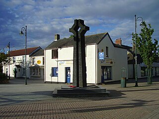
Rogiet is a small village and community in Monmouthshire, south east Wales, between Caldicot and Magor, 8 miles (13 km) west of Chepstow and 11 miles (18 km) east of Newport, which covers an area of 847 hectares (3.27 sq mi). It lies close to the M4 and M48 motorways, and the Second Severn Crossing. It has a railway station named Severn Tunnel Junction. Rogiet only has a population of 1,813 (2011).

<span class="mw-page-title-main">Severn Estuary</span> Estuary and Site of Special Scientific Interest in Great Britain

The Severn Estuary is the estuary of the River Severn, flowing into the Bristol Channel between South West England and South Wales. Its very high tidal range, approximately 50 feet (15 m), creates valuable intertidal habitats and has led to the area being at the centre of discussions in the UK regarding renewable tidal energy.

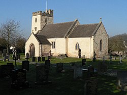
Crick is a small village or hamlet in the Welsh county of Monmouthshire, United Kingdom. It is located on the A48 road 1 mile north of the town of Caldicot and 1 mile east of Caerwent.

<span class="mw-page-title-main">Magor, Monmouthshire</span> Human settlement in Wales

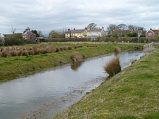
Magor is a large village in Monmouthshire, south east Wales, about 9 miles (14 km) west of Chepstow and about 9 miles (14 km) east of Newport. It lies on the Caldicot Levels beside the Severn Estuary, and is in the community of Magor with Undy. Magor lies close to the M4 motorway.

<span class="mw-page-title-main">St. Brides Netherwent</span>

St. Brides Netherwent is a parish and largely deserted village in Monmouthshire, south-east Wales. It is centred 2 miles north of Magor, and 3 miles west of Caerwent. The A48 Newport to Chepstow road passes close by to the north.

<span class="mw-page-title-main">Llanvair Discoed</span> Human settlement in Wales

Llanvair Discoed is a small village in Monmouthshire, south-east Wales, 6 miles west of Chepstow and 10 miles east of Newport.

<span class="mw-page-title-main">Venta Silurum</span> Historic site in Wales, UK

Venta Silurum was a town in Roman Britain (Britannia). Today it consists of remains in the village of Caerwent in Monmouthshire, south east Wales.

<span class="mw-page-title-main">Goldcliff, Newport</span> Village in the city of Newport, South Wales

Goldcliff is a village, parish and community to the south east of the city of Newport in South Wales. It lies within the Newport city boundaries in the historic county of Monmouthshire and the preserved county of Gwent. Administratively, the community of Goldcliff includes the village/parish of Whitson. The population in 2001 was 233; by 2011 it had risen to 329.

<span class="mw-page-title-main">Kingdom of Gwent</span> Kingdom in South Wales

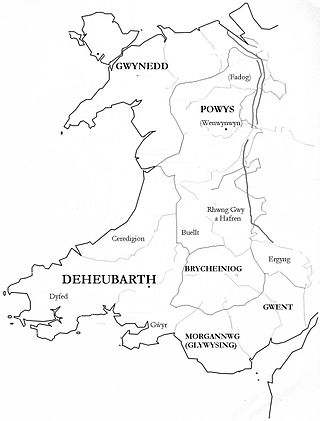
Gwent was a medieval Welsh kingdom, lying between the Rivers Wye and Usk. It existed from the end of Roman rule in Britain in about the 5th century until the Norman invasion of Wales in the 11th century. Along with its neighbour Glywyssing, it seems to have had a great deal of cultural continuity with the earlier Silures, keeping their own courts and diocese separate from the rest of Wales until their conquest by Gruffydd ap Llywelyn. Although it recovered its independence after his death in 1063, Gwent was the first of the Welsh kingdoms to be overrun following the Norman conquest.

<span class="mw-page-title-main">Sudbrook, Monmouthshire</span> Human settlement in Wales

Sudbrook is a village in Monmouthshire, south east Wales. It is located 4 miles south west of Chepstow and 1 mile east of Caldicot. It lies close to the Second Severn Crossing on the Severn Estuary, and adjoins the village of Portskewett. It was largely built in the late 19th century for workers on the Severn railway tunnel. At that time it was also known as Southbrook.

<span class="mw-page-title-main">Gray Hill, Monmouthshire</span>

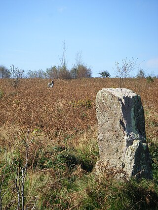
Gray Hill is a hill immediately to the north of the village of Llanvair Discoed, Monmouthshire, South Wales, rising to 896 feet (273 m) above sea level.

<span class="mw-page-title-main">St Pierre, Monmouthshire</span> Human settlement in Wales

St Pierre is a former parish and hamlet in Monmouthshire, south east Wales, 3 miles (4.8 km) south west of Chepstow and adjacent to the Severn Estuary. It is now the site of a large golf and country club, the Marriott St Pierre Hotel & Country Club, which was previously a large manor house and deer park belonging to the Lewis family.

<span class="mw-page-title-main">Lave net</span>

A lave net is a type of fishing net used in river estuaries, particularly in the Severn Estuary in Wales and England to catch salmon.

Gwent Wildlife Trust (GWT) is a wildlife trust covering the area between the lower Wye and Rhymney rivers which forms the vice county of Monmouthshire in south-east Wales. It is a registered charity and a member of the Wildlife Trusts Partnership.

Saint Tathyw was a 5th-century saint of South Wales, and founder of a monastic school at Caerwent where he instructed many of the leading figures of the early Welsh church.

<span class="mw-page-title-main">Portskewett Pier railway station</span> Former railway station in Wales

Portskewett Pier was a station on the Bristol & South Wales Union Railway. The pier at Black Rock, near Portskewett, was the Welsh side of the New Passage Ferry across the River Severn. The ferry linked rail services between Bristol and South Wales, avoiding the previous long detour through Gloucester. The ferry service lasted for nearly twenty five years, from 1863 to 1886, until the opening of the railway tunnel beneath the river.

The East Gwent Association Football League is a football league covering the eastern part of the preserved country of Gwent. It is affiliated to the Gwent County Football Association. The leagues are at the seventh and eighth levels of the Welsh football league system.

<span class="mw-page-title-main">Nedern Brook Wetlands</span>

The Nedern Brook Wetland is a flood meadow habitat near Caldicot, Monmouthshire, Wales, designated since 1988 as a Site of Special Scientific Interest (SSSI). The site is of 44.5 hectares and is bridged by the M48 motorway. The spelling Neddern is used in some documents. Nedern Brook is also called Troggy Brook.

<span class="mw-page-title-main">Fishing industry in Wales</span> Sector of the Welsh economy

The fishing industry in Wales is a sector of the Welsh economy.

References

  1. "Community and ward population 2011" . Retrieved 4 April 2015.
  2. "Heston Brake". Archived from the original on 2 October 2011. Retrieved 21 December 2007.
  3. Map of Heston Brake
  4. 1 2 3 Hando. F. J., 1954, Monmouthshire Sketch Book, Newport, R. H. Johns, Chapter VI - Black Rock and Heston Brake.
  5. 1 2 "South East Wales in the Early Medieval Period". Archived from the original on 17 May 2011. Retrieved 21 May 2008.
  6. 1 2 3 Miranda Aldhouse-Green and Ray Howell (eds.), Gwent In Prehistory and Early History: The Gwent County History Vol.1, 2004, ISBN   0-7083-1826-6
  7. 1 2 3 "Archived copy" (PDF). Archived from the original (PDF) on 21 November 2008. Retrieved 10 December 2007.{{cite web}}: CS1 maint: archived copy as title (link)
  8. Channel 4 Time Team site
  9. Photo of St. Mary's Church
  10. Population statistics
  11. "Archived copy" (PDF). Archived from the original (PDF) on 21 November 2008. Retrieved 12 December 2007.{{cite web}}: CS1 maint: archived copy as title (link)
  12. "Archived copy" (PDF). Archived from the original (PDF) on 9 August 2007. Retrieved 12 December 2007.{{cite web}}: CS1 maint: archived copy as title (link)
  13. index Archived 2009-07-10 at the Wayback Machine
  14. "NOAA Tides & Currents". Archived from the original on 18 March 2021. Retrieved 23 March 2013.
  15. About tides – Tides: questions and answers | National Tidal and Sea Level Facility
  16. BBC Countryfile episode on Gwent Levels | South Wales Argus
  17. Dan Barnes, "Natural Resources Wales rules threaten Severn Estuary fishery", The National, 17 May 2021. Retrieved 1 June 2021
  18. The Black Rock Lave Net Heritage Fishery. Retrieved 1 June 2021
  19. "River Severn Net Limitation Order and Byelaws 2021", Environment Agency. Retrieved 1 June 2021
  20. The County of Monmouthshire (Electoral Changes) Order 2002. Statutory Instruments. 6 December 2002. Retrieved 29 December 2018.{{cite book}}: |website= ignored (help)
  21. "Monmouthshire County Council Election Results 1995-2012" (PDF). The Elections Centre. Retrieved 30 December 2018.
  22. "County Councillor Peter Fox". Monmouthshire County Council. Retrieved 30 December 2018.

Bibliography