Sudbrook, Monmouthshire

Last updated

Sudbrook
Sudbrook.jpg
Sudbrook showing the line of the old branch railway which divides the village
Monmouthshire UK location map.svg
Red pog.svg
Sudbrook
Location within Monmouthshire
OS grid reference ST502876
Principal area
Preserved county
Country Wales
Sovereign state United Kingdom
Post town CALDICOT
Postcode district NP26
Dialling code 01291
Police Gwent
Fire South Wales
Ambulance Welsh
UK Parliament
List of places
UK
Wales
Monmouthshire
51°34′54″N2°42′57″W / 51.5818°N 2.7157°W / 51.5818; -2.7157

Sudbrook is a village in Monmouthshire, south east Wales. It is located 4 miles south west of Chepstow and 1 mile east of Caldicot. It lies close to the Second Severn Crossing on the Severn Estuary, and adjoins the village of Portskewett. It was largely built in the late 19th century for workers on the Severn railway tunnel. At that time it was also known as Southbrook.

Contents

History

View of the hillfort, showing part of the ramparts Iron age hillfort, Sudbrook.jpg
View of the hillfort, showing part of the ramparts

Sudbrook hill fort

Sudbrook was of early historic importance in guarding the Severn estuary at an ancient ferry crossing place. An Iron Age hillfort is located on the coast, probably built and occupied by the Silures from the 2nd century BC and occupied by the Romans from the 1st century AD until the 4th century. The hillfort was originally much bigger than now having been eroded over the centuries. Finds of Roman coins at Black Rock, Portskewett, show that the ferry crossing was in use in Roman times, on the route between the Roman stations of Aquae Sulis (Bath) and Venta Silurum (Caerwent). [1] [2] [3]

According to tradition, Caradog Freichfras, the Welsh ruler of Gwent in the 5th century or 6th century AD, moved his court from Caerwent to the Portskewett area, possibly to the fort. [4] [5]

Holy Trinity Church

The ruined Holy Trinity church stands near the Severn cliff. It has mostly fallen into the sea over the centuries. The nave walls date from the 12th century; the chancel was added in the 14th century and the south porch in the 15th century. The preaching cross which is now inside the church was originally outside and was probably moved to prevent it falling into the sea as the cliff eroded. The area around the church was probably the site of the original medieval village. A manor house and other village buildings stood nearby but later moved inland, probably when climate changes in the 14th and 15th centuries led to the widening of the estuary and the erosion of the cliff. By 1720 the church had fallen down and much of the churchyard had fallen into the river with human bones from the graves often being found on the shore. [1]

Severn Tunnel old pump house Severn Tunnel pump house, Sudboook.jpg
Severn Tunnel old pump house

Sudbrook village and the Severn Tunnel

Most of Sudbrook was built as a new village for workers on the Severn Tunnel, on which construction began in 1873. The first cottages were built by contractor Thomas A. Walker in 1877, and rapid development took place over the next decade, including a school, post office, mission hall and infirmary. Some of the houses - originally known as Concrete Row - are believed to be the first concrete houses built in Britain.

Also built was a large pumping station, required to pump water from the tunnel, including three large brick engine houses housing six steam engines, and ventilation towers. The steam engines were replaced by electrical engines in 1962, and the chimney stacks taking smoke from the furnaces were demolished in 1968. [1]

After the Severn Tunnel was opened in 1886, Walker started a shipbuilding business at Sudbrook, using the same labour force. This continued in operation, building steamers of up to 700 tonnes, until 1926.

Between 1958 and 2006, local employment in the village was provided by a large paper mill, which made use of water from the tunnel.

Sudbrook Cricket Club

Sudbrook Cricket Club was formed during the 1860s. [6] It is believed that in the 1870s cricket was played at Black Rock, where W. G. Grace played against Sudbrook for a Bristol team. The team later played matches within the Iron Age camp, before moving several times, eventually to Caldicot where it remains. [7] The club achieved league status in the 1970s, and currently plays in Division One of the Glamorgan and Monmouthshire Cricket League. [8]

Amenities

In 2002 Ysgol y Ffin, one of only two Welsh language based primary schools in Monmouthshire, was established in the old school building at Sudbrook. However, in 2008 the school outgrew the site and moved to Sandy Lane in Caldicot.

See also

Further reading

Related Research Articles

<span class="mw-page-title-main">Severn Tunnel</span> Tunnel linking the South of England and Wales

The Severn Tunnel is a railway tunnel in the United Kingdom, linking South Gloucestershire in the west of England to Monmouthshire in south Wales under the estuary of the River Severn. It was constructed by the Great Western Railway (GWR) between 1873 and 1886 for the purpose of dramatically shortening the journey times of their trains, passenger and goods alike, between South Wales and Western England. It has often been regarded as the crowning achievement of GWR's chief engineer Sir John Hawkshaw.

<span class="mw-page-title-main">Monmouthshire</span> County in Wales

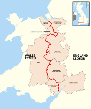
Monmouthshire is a county in the south east of Wales. It borders Powys to the north; the English counties of Herefordshire and Gloucestershire to the north and east; the Severn Estuary to the south, and Torfaen, Newport and Blaenau Gwent to the west. The largest town is Abergavenny, and the administrative centre is Usk.

<span class="mw-page-title-main">Caldicot</span> Town in Wales

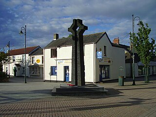
Caldicot is a market town and community in Monmouthshire, Wales. The town is located between Chepstow and the city of Newport. The site adjoins the Caldicot Levels, on the north side of the Severn Estuary. The population of the built-up area was around 11,000. It has a large school, Caldicot School, and is known for its medieval castle. The built-up area includes Portskewett. Caldicot had a population of 9,604 in 2011.

<span class="mw-page-title-main">Caerwent</span> Human settlement in Monmouthshire, Wales

Caerwent is a village and community in Monmouthshire, Wales. It is located about five miles west of Chepstow and 11 miles east of Newport. It was founded by the Romans as the market town of Venta Silurum, an important settlement of the Brythonic Silures tribe. The modern village is built around the Roman ruins, which are some of the best-preserved in Europe. It remained prominent through the Roman era and Early Middle Ages as the site of a road crossing between several important civic centres. The community includes Llanvair Discoed. The village itself had a population of about 1,200.

<span class="mw-page-title-main">Rogiet</span> Human settlement in Wales

Rogiet is a small village and community in Monmouthshire, south east Wales, between Caldicot and Magor, 8 miles (13 km) west of Chepstow and 11 miles (18 km) east of Newport, which covers an area of 847 hectares (3.27 sq mi). It lies close to the M4 and M48 motorways, and the Second Severn Crossing. It has a railway station named Severn Tunnel Junction. Rogiet only has a population of 1,813 (2011).

Crick is a small village or hamlet in the Welsh county of Monmouthshire, United Kingdom. It is located on the A48 road 1 mile north of the town of Caldicot and 1 mile east of Caerwent.

<span class="mw-page-title-main">Magor, Monmouthshire</span> Human settlement in Wales

Magor is a large village in Monmouthshire, south east Wales, about 9 miles (14 km) west of Chepstow and about 9 miles (14 km) east of Newport. It lies on the Caldicot Levels beside the Severn Estuary, and is in the community of Magor with Undy. Magor lies close to the M4 motorway.

<span class="mw-page-title-main">Caerwent Training Area</span>

Caerwent Training Area is a British military installation at Caerwent, Monmouthshire, Wales. The large military site is situated north of the A48 road about 5 mi (8.0 km) west of Chepstow and 12 miles (19 km) east of Newport.

<span class="mw-page-title-main">Caldicot railway station</span> Railway station in Monmouthshire, Wales

Caldicot railway station is a part of the British railway system owned by Network Rail and is operated by Transport for Wales. It serves the town of Caldicot in Monmouthshire, Wales. It is located between Chepstow and the city of Newport on the Gloucester line, 148 miles 2 chains (238.2 km) from the zero point at Paddington, measured via Stroud. The line to Bristol via the Severn Tunnel runs just to the north but there are no platforms here; however, Severn Tunnel Junction station is within walking distance for those wanting to travel to Bristol.

<span class="mw-page-title-main">Llanvair Discoed</span> Human settlement in Wales

Llanvair Discoed is a small village in Monmouthshire, south-east Wales, 6 miles west of Chepstow and 10 miles east of Newport.

<span class="mw-page-title-main">Venta Silurum</span> Historic site in Wales, UK

Venta Silurum was a town in Roman Britain (Britannia). Today it consists of remains in the village of Caerwent in Monmouthshire, south east Wales.

<span class="mw-page-title-main">Caldicot and Wentloog Levels</span> Coastal plain and wetlands in Monmouthshire, Wales

The Caldicot and Wentloog Levels are two areas of low-lying estuarine alluvial wetland and intertidal mudflats adjoining the north bank of the Severn Estuary, either side of the River Usk estuary near Newport in south east Wales. They are also known collectively as the Monmouthshire Levels or Gwent Levels, and the name Wentloog is sometimes spelled Wentlooge in official publications.

<span class="mw-page-title-main">Kingdom of Gwent</span> Kingdom in South Wales

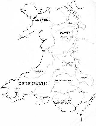
Gwent was a medieval Welsh kingdom, lying between the Rivers Wye and Usk. It existed from the end of Roman rule in Britain in about the 5th century until the Norman invasion of Wales in the 11th century. Along with its neighbour Glywyssing, it seems to have had a great deal of cultural continuity with the earlier Silures, keeping their own courts and diocese separate from the rest of Wales until their conquest by Gruffydd ap Llywelyn. Although it recovered its independence after his death in 1063, Gwent was the first of the Welsh kingdoms to be overrun following the Norman conquest.

<span class="mw-page-title-main">Portskewett</span> Village and community in Monmouthshire, Wales

Portskewett is a village and community (parish) in Monmouthshire, south east Wales. It is located four miles south west of Chepstow and one mile east of Caldicot, in an archaeologically sensitive part of the Caldicot Levels on the Welsh shore of the Severn Estuary. The Second Severn Crossing passes overhead carrying the M4 motorway. The community includes Sudbrook, Crick and Leechpool.

<span class="mw-page-title-main">Gray Hill, Monmouthshire</span>

Gray Hill is a hill immediately to the north of the village of Llanvair Discoed, Monmouthshire, South Wales, rising to 896 feet (273 m) above sea level.

<span class="mw-page-title-main">St Pierre, Monmouthshire</span> Human settlement in Wales

St Pierre is a former parish and hamlet in Monmouthshire, south east Wales, 3 miles (4.8 km) south west of Chepstow and adjacent to the Severn Estuary. It is now the site of a large golf and country club, the Marriott St Pierre Hotel & Country Club, which was previously a large manor house and deer park belonging to the Lewis family.

<span class="mw-page-title-main">England–Wales border</span> National boundary between England and Wales

The England–Wales border, sometimes referred to as the Wales–England border or the Anglo-Welsh border, runs for 160 miles (260 km) from the Dee estuary, in the north, to the Severn estuary in the south, separating England and Wales.

<span class="mw-page-title-main">Portskewett Pier railway station</span> Former railway station in Wales

Portskewett Pier was a station on the Bristol & South Wales Union Railway. The pier at Black Rock, near Portskewett, was the Welsh side of the New Passage Ferry across the River Severn. The ferry linked rail services between Bristol and South Wales, avoiding the previous long detour through Gloucester. The ferry service lasted for nearly twenty five years, from 1863 to 1886, until the opening of the railway tunnel beneath the river.

The East Gwent Association Football League is a football league covering the eastern part of the preserved country of Gwent. It is affiliated to the Gwent County Football Association. The leagues are at the seventh and eighth levels of the Welsh football league system.

<span class="mw-page-title-main">Nedern Brook Wetlands</span>

The Nedern Brook Wetland is a flood meadow habitat near Caldicot, Monmouthshire, Wales, designated since 1988 as a Site of Special Scientific Interest (SSSI). The site is of 44.5 hectares and is bridged by the M48 motorway. The spelling Neddern is used in some documents. Nedern Brook is also called Troggy Brook.

References

  1. 1 2 3 "Archived copy" (PDF). Archived from the original (PDF) on 21 November 2008. Retrieved 12 December 2007.{{cite web}}: CS1 maint: archived copy as title (link)
  2. "Severnsideforum.co.uk" (PDF). Archived from the original (PDF) on 9 August 2007. Retrieved 12 December 2007.
  3. http://www.monmouthshire.gov.uk/NR/rdonlyres/642F4FB5-FB98-4D79-B0D5-595810D70D87/0/LANDMAPVolume5CulturalAspectTA13MB.pdf%5B%5D
  4. Miranda Aldhouse-Green and Ray Howell (eds.), Gwent In Prehistory and Early History: The Gwent County History Vol.1, 2004, ISBN   0-7083-1826-6
  5. "Archived copy" (PDF). Archived from the original (PDF) on 21 November 2008. Retrieved 10 December 2007.{{cite web}}: CS1 maint: archived copy as title (link)
  6. Sudbrook community website
  7. Sudbrook Cricket Club league details Archived 2013-01-31 at archive.today
  8. Glamorgan and Monmouthshire Cricket League Archived 2012-07-09 at archive.today