
A postal code is a series of letters or digits or both, sometimes including spaces or punctuation, included in a postal address for the purpose of sorting mail.

A ZIP Code is a postal code used by the United States Postal Service (USPS). Introduced in 1963, the basic format consisted of five digits. In 1983, an extended ZIP+4 code was introduced; it included the five digits of the ZIP Code, followed by a hyphen and four digits that designated a more specific location.
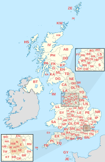
Postal codes used in the United Kingdom, British Overseas Territories and Crown Dependencies are known as postcodes. They are alphanumeric and were adopted nationally between 11 October 1959 and 1974, having been devised by the General Post Office. A full postcode is known as a "postcode unit" and designates an area with several addresses or a single major delivery point.

Isla Culebra is an island, town and municipality of Puerto Rico and geographically part of the Spanish Virgin Islands. It is located approximately 17 miles (27 km) east of the Puerto Rican mainland, 12 miles (19 km) west of St. Thomas and 9 miles (14 km) north of Vieques. Culebra is spread over 5 barrios and Culebra Pueblo (Dewey), the main town and the administrative center of the island. Residents of the island are known as culebrenses. With a population of 1,792 as of the 2020 Census, it is Puerto Rico's least populous municipality.

Guaynabo is a city, suburb of San Juan and municipality in the northern part of Puerto Rico, located in the northern coast of the island, north of Aguas Buenas, south of Cataño, east of Bayamón, and west of San Juan. Guaynabo is spread over 9 barrios and Guaynabo Pueblo. Guaynabo is considered, along with its neighbors – San Juan and the municipalities of Bayamón, Carolina, Cataño, Trujillo Alto, and Toa Baja – to be part of the San Juan metropolitan area. It is also part of the larger San Juan-Caguas-Guaynabo Metropolitan Statistical Area,.
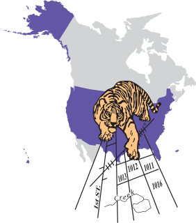
Topologically Integrated Geographic Encoding and Referencing, or TIGER, or TIGER/Line is a format used by the United States Census Bureau to describe land attributes such as roads, buildings, rivers, and lakes, as well as areas such as census tracts. TIGER was developed to support and improve the Bureau's process of taking the Decennial Census.
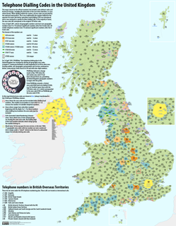
Telephone numbers in the United Kingdom are administered by the Office of Communications (Ofcom). For this purpose, Ofcom established a telephone numbering plan, known as the National Telephone Numbering Plan, which is the system for assigning telephone numbers to subscriber stations.
An address is a collection of information, presented in a mostly fixed format, used to give the location of a building, apartment, or other structure or a plot of land, generally using political boundaries and street names as references, along with other identifiers such as house or apartment numbers and organization name. Some addresses also contain special codes, such as a postal code, to make identification easier and aid in the routing of mail.

Air Sunshine is an airline based in the United States and in Puerto Rico. It operates scheduled service to and from San Juan and Vieques, Puerto Rico, St. Lucia, Anguilla, Dominica, Sint Maarten, Nevis, St. Kitts, Tortola and Virgin Gorda in the British Virgin Islands and Saint Thomas, US Virgin Islands. Its main base is Fort Lauderdale, with a Caribbean hub located in San Juan, Puerto Rico.
The integration of the Caribbean telephone networks into the North American Numbering Plan (NANP) began with the assignment of area codes in the Caribbean in 1958, when area code 809 was designated for Bermuda and any other potential participant island countries.

The following outline is provided as an overview of and topical guide to Puerto Rico:

The San Juan metropolitan area is a United States Census Bureau defined metropolitan statistical area (MSA) in northeastern Puerto Rico centered around the city of San Juan. A July 1, 2009, Census Bureau estimate placed the population at 2,617,089, a 4.31% increase over the 2000 census figure of 2,509,007.
A network distribution center (NDC) is a highly mechanized mail processing plant of the United States Postal Service that distributes standard mail and package services in piece and bulk form.
Puerto Rico topics have been featured on the stamps of Spain and of the United States. Spanish stamps are found at Postage stamps and postal history of Puerto Rico.

The Roads in Puerto Rico are the national, forest and municipal roadways that make up the approximately 14,400 kilometers (8,900 mi) roads through the terrain of Puerto Rico. The highways serve the more than 3 million residents, and 3-4 million tourists who visit each year.

Postcodes used in Oceania vary between the various sovereign nations, territories, and associated states in the region. Many of the smaller island regions in Oceania use postal code systems that are integrated into the postal systems of larger countries they are territories or associates of.
