Prediction of volcanic activity, and volcanic eruption forecasting, is an interdisciplinary monitoring and research effort to predict the time and severity of a volcano's eruption. Of particular importance is the prediction of hazardous eruptions that could lead to catastrophic loss of life, property, and disruption of human activities.
Risk and uncertainty are central to forecasting and prediction, which are not necessarily the same thing in the context of volcanoes, but both have a process based on past and present data.
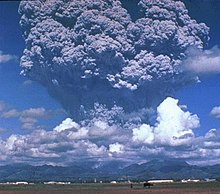
Mount St. Helens erupted explosively on May 18, 1980, at 8:32 a.m. PDT
Seismic waves (seismicity)
General principles of volcano seismology
Seismic activity (earthquakes and tremors) always occurs as volcanoes awaken and prepare to erupt and are a very important link to eruptions. Some volcanoes normally have continuing low-level seismic activity, but an increase may signal a greater likelihood of an eruption. The types of earthquakes that occur and where they start and end are also key signs. Volcanic seismicity has three major forms: short-period earthquake, long-period earthquake, and harmonic tremor.
Short-period earthquakes are like normal fault-generated earthquakes. They are caused by the fracturing of brittle rock as magma forces its way upward. These short-period earthquakes signify the growth of a magma body near the surface and are known as 'A' waves. These type of seismic events are often also referred to as Volcano-Tectonic (or VT) events or earthquakes.
Long-period earthquakes are believed to indicate increased gas pressure in a volcano's plumbing system. They are similar to the clanging sometimes heard in a house's plumbing system, which is known as "water hammer". These oscillations are the equivalent of acoustic vibrations in a chamber, in the context of magma chambers within the volcanic dome and are known as 'B' waves. These are also known as resonance waves and long period resonance events.
Harmonic tremors are often the result of magma pushing against the overlying rock below the surface. They can sometimes be strong enough to be felt as humming or buzzing by people and animals, hence the name.
Patterns of seismicity are complex and often difficult to interpret; however, increasing seismic activity is a good indicator of increasing eruption risk, especially if long-period events become dominant and episodes of harmonic tremor appear.
Using a similar method, researchers can detect volcanic eruptions by monitoring infra-sound—sub-audible sound below 20Hz. The IMS Global Infrasound Network, originally set up to verify compliance with nuclear test ban treaties, has 60 stations around the world that work to detect and locate erupting volcanoes.[1]
Seismic case studies
A relation between long-period events and imminent volcanic eruptions was first observed in the seismic records of the 1985 eruption of Nevado del Ruiz in Colombia. The occurrence of long-period events were then used to predict the 1989 eruption of Mount Redoubt in Alaska and the 1993 eruption of Galeras in Colombia. In December 2000, scientists at the National Center for Prevention of Disasters in Mexico City predicted an eruption within two days at Popocatépetl, on the outskirts of Mexico City. Their prediction used research that had been done by Bernard Chouet, a Swiss volcanologist who was working at the United States Geological Survey and who first observed a relation between long-period events and an imminent eruption.[2][3][4] The government evacuated tens of thousands of people; 48 hours later, the volcano erupted as predicted. It was Popocatépetl's largest eruption for a thousand years, yet no one was hurt.
Iceberg tremors
Similarities between icebergtremors, which occur when they run aground, and volcanic tremors may help experts develop a better method for predicting volcanic eruptions. Although icebergs have much simpler structures than volcanoes, they are physically easier to work with. The similarities between volcanic and iceberg tremors include long durations and amplitudes, as well as common shifts in frequencies.[5]
Gas emissions
Gas and ash plume erupted from Mount Pinatubo, Philippines.
As magma nears the surface and its pressure decreases, gases escape. This process is much like what happens when you open a bottle of fizzy drink and carbon dioxide escapes. Sulfur dioxide is one of the main components of volcanic gases, and increasing amounts of it herald the arrival of increasing amounts of magma near the surface. For example, on May 13, 1991, an increasing amount of sulfur dioxide was released from Mount Pinatubo in the Philippines. On May 28, just two weeks later, sulfur dioxide emissions had increased to 5,000 tonnes, ten times the earlier amount. Mount Pinatubo later erupted on June 12, 1991. On several occasions, such as before the Mount Pinatubo eruption and the 1993 Galeras, Colombia eruption, sulfur dioxide emissions have dropped to low levels prior to eruptions. Most scientists believe that this drop in gas levels is caused by the sealing of gas passages by hardened magma. Such an event leads to increased pressure in the volcano's plumbing system and an increased chance of an explosive eruption. A multi-component gas analyzer system (Multi-GAS) is an instrument package used to take real-time high-resolution measurements of volcanic gas plumes.[6] Multi-GAS measurements of CO2/SO2 ratios can allow detection of the pre-eruptive degassing of rising magmas, improving prediction of volcanic activity.[6]
Swelling of a volcano signals that magma has accumulated near the surface. Scientists monitoring an active volcano will often measure the tilt of the slope and track changes in the rate of swelling. An increased rate of swelling, especially if accompanied by an increase in sulfur dioxide emissions and harmonic tremors is a high probability sign of an impending event. The deformation of Mount St. Helens prior to the May 18, 1980 eruption was a classic example of deformation, as the north side of the volcano was bulging upwards as magma was building up underneath. Most cases of ground deformation are usually detectable only by sophisticated equipment used by scientists, but they can still predict future eruptions this way. The Hawaiian volcanoes show significant ground deformation; there is inflation of the ground prior to an eruption and then an obvious deflation post-eruption. This is due to the shallow magma chamber of the Hawaiian volcanoes; movement of the magma is easily noticed on the ground above.[7]
Thermal monitoring
Both magma movement, changes in gas release and hydrothermal activity can lead to thermal emissivity changes at the volcano's surface. These can be measured using several techniques:
There are 4 main methods that can be used to predict a volcanic eruption through the use of hydrology:
Borehole and well hydrologic and hydraulic measurements are increasingly used to monitor changes in a volcanoes subsurface gas pressure and thermal regime. Increased gas pressure will make water levels rise and suddenly drop right before an eruption, and thermal focusing (increased local heat flow) can reduce or dry out aquifers.
Detection of lahars and other debris flows close to their sources. USGS scientists have developed an inexpensive, durable, portable and easily installed system to detect and continuously monitor the arrival and passage of debris flows and floods in river valleys that drain active volcanoes.
Pre-eruption sediment may be picked up by a river channel surrounding the volcano that shows that the actual eruption may be imminent. Most sediment is transported from volcanically disturbed watersheds during periods of heavy rainfall. This can be an indication of morphological changes and increased hydrothermal activity in absence of instrumental monitoring techniques.
Volcanic deposit that may be placed on a river bank can easily be eroded which will dramatically widen or deepen the river channel. Therefore, monitoring of the river channels width and depth can be used to assess the likelihood of a future volcanic eruption.
Remote sensing
Remote sensing is the detection by a satellite's sensors of electromagnetic energy that is absorbed, reflected, radiated or scattered from the surface of a volcano or from its erupted material in an eruption cloud.
'Cloud sensing: Scientists can monitor the unusually cold eruption clouds from volcanoes using data from two different thermal wavelengths to enhance the visibility of eruption clouds and discriminate them from meteorological clouds
'Gas sensing: Sulfur dioxide can also be measured by remote sensing at some of the same wavelengths as ozone. Total Ozone Mapping Spectrometers (TOMS) can measure the amount of sulfur dioxide gas released by volcanoes in eruptions. Carbon dioxide emissions from volcanoes have been detected in the short-wave infrared using NASA'sOrbiting Carbon Observatory 2.[8]
Thermal sensing: The presence of new significant thermal signatures or 'hot spots' may indicate new heating of the ground before an eruption, represent an eruption in progress or the presence of a very recent volcanic deposit, including lava flows or pyroclastic flows.
Deformation sensing: Satellite-borne spatial radar data can be used to detect long-term geometric changes in the volcanic edifice, such as uplift and depression. In this method, interferometric synthetic aperture radar (InSAR), digital elevation models generated from radar imagery are subtracted from each other to yield a differential image, displaying rates of topographic change.
Forest monitoring: Recently, it has been demonstrated that the location of eruptive fractures could be predicted, months to years before the eruptions, by the monitoring of forest growth. This tool based on the monitoring of the trees growth has been validated at both Mt. Niyragongo and Mt. Etna during the 2002–2003 volcano eruptive events.[9]
Infrasound sensing: A relatively new approach to detecting volcanic eruptions involves using infrasound sensors from the International Monitoring System (IMS) infrasound network. This method of detection takes signals from multiple sensors and uses triangulation to determine the location of the eruption.[10]
Mass movements and mass failures
Monitoring mass movements and failures uses techniques lending from seismology (geophones), deformation, and meteorology. Landslides, rock falls, pyroclastic flows, and mud flows (lahars) are example of mass failures of volcanic material before, during, and after eruptions.
The most famous volcanic landslide was probably the failure of a bulge that built up from intruding magma before the Mt. St. Helens eruption in 1980, this landslide "uncorked" the shallow magmatic intrusion causing catastrophic failure and an unexpected lateral eruption blast. Rock falls often occur during periods of increased deformation and can be a sign of increased activity in absence of instrumental monitoring. Mud flows (lahars) are remobilized hydrated ash deposits from pyroclastic flows and ash fall deposits, moving downslope even at very shallow angles at high speed. Because of their high density they are capable of moving large objects such as loaded logging trucks, houses, bridges, and boulders. Their deposits usually form a second ring of debris fans around volcanic edifices, the inner fan being primary ash deposits. Downstream of the deposition of their finest load, lahars can still pose a sheet flood hazard from the residual water. Lahar deposits can take many months to dry out, until they can be walked on. The hazards derived from lahar activity can exist several years after a large explosive eruption.
A team of US scientists developed a method of predicting lahars. Their method was developed by analyzing rocks on Mount Rainier in Washington. The warning system depends on noting the differences between fresh rocks and older ones. Fresh rocks are poor conductors of electricity and become hydrothermically altered by water and heat. Therefore, if they know the age of the rocks, and therefore the strength of them, they can predict the pathways of a lahar.[11] A system of Acoustic Flow Monitors (AFM) has also been emplaced on Mount Rainier to analyze ground tremors that could result in a lahar, providing an earlier warning.[12]
Local case studies
Nyiragongo
The eruption of Mount Nyiragongo on January 17, 2002, was predicted a week earlier by a local expert who had been studying the volcanoes for years. He informed the local authorities and a UN survey team was dispatched to the area; however, it was declared safe. Unfortunately, when the volcano erupted, 40% of the city of Goma was destroyed along with many people's livelihoods. The expert claimed that he had noticed small changes in the local relief and had monitored the eruption of a much smaller volcano two years earlier. Since he knew that these two volcanoes were connected by a small fissure, he knew that Mount Nyiragongo would erupt soon.[13]
Mount Etna
British geologists have developed a method of predicting future eruptions of Mount Etna. They have discovered that there is a time lag of 25 years between events. Monitoring of deep crust events can help predict accurately what will happen in the years to come. So far they have predicted that between 2007 and 2015, volcanic activity will be half of what it was in 1972.[14][citation needed] Other methods of predicting volcanic activity is by examining the increase of CO2/SO2 ratios. These ratios will indicate pre-eruptive degassing of magma chambers. A team of researchers used Mount Etna for this research by observing gases such as H2O, CO2, and SO2. The team did a real-time monitoring of Mount Etna before it experienced eruptions in July and December 2006. These CO2/SO2 ratios are useful in that the increase of these ratios are a predecessor to upcoming eruptions due to the acceleration of gas-rich magmas and replenishes the magma chamber. In the two years of observations that the team conducted, the increase of these ratios are a precursor to upcoming eruptions. It was recorded that in the months prior before an eruption, the ratios increased and led to an eruption after it had reached its peak amount. It was concluded that measuring H2O, CO2, and SO2 can be a useful method to predict volcanic activity, especially at Mount Etna.[15] Mount Etna's prediction of volcanic activity can also be used with 4D microgravity analysis. This type of analysis uses GPS and synthetic aperture radar interferometry (InSAR). It can measure the changes in density, and afterwards, can retrieve a model to show magma movements and spatial scales that are occurring within a volcanic system. Back in 2001, gravity models detected that there was a decrease in the mass of Mount Etna of 2.5×10¹¹ kg. Eventually, there was a sudden increase in the mass two weeks prior to an eruption. The volcano made up for this decrease in magma by retrieving more magma from its storage zone to bring up to the upper levels of the plumbing system. Due to this retrieval, it led to an eruption. The microgravity studies that were performed by this team shows the migration of magma and gas within a magma chamber prior to any eruption, which can be a useful method to any prediction of volcanic activity.[16]
Sakurajima, Japan
Sakurajima is possibly one of the most monitored areas on earth. The Sakurajima Volcano lies near Kagoshima City, which has a population of over 500,000 people. Both the Japanese Meteorological Agency (JMA) and Kyoto University's Sakurajima Volcanological Observatory (SVO) monitors the volcano's activity. Since 1995, Sakurajima has only erupted from its summit with no release of lava.
Monitoring techniques at Sakurajima:
Likely activity is signalled by swelling of the land around the volcano as magma below begins to build up. At Sakurajima, this is marked by a rise in the seabed in Kagoshima Bay – tide levels rise as a result.
As magma begins to flow, melting and splitting base rock can be detected as volcanic earthquakes. At Sakurajima, they occur two to five kilometres beneath the surface. An underground observation tunnel is used to detect volcanic earthquakes more reliably.
Groundwater levels begin to change, the temperature of hot springs may rise and the chemical composition and amount of gases released may alter. Temperature sensors are placed in bore holes which are used to detect ground water temp. Remote sensing is used on Sakurajima since the gases are highly toxic – the ratio of HCl gas to SO2 gas increases significantly shortly before an eruption.
As an eruption approaches, tiltmeter systems measure minute movements of the mountain. Data is relayed in real-time to monitoring systems at SVO.
Seismometers detect earthquakes which occur immediately beneath the crater, signaling the onset of the eruption. They occur 1 to 1.5 seconds before the explosion.
With the passing of an explosion, the tiltmeter system records the settling of the volcano.
Mitigations
Going beyond predicting volcanic activity, there are highly speculative proposals to prevent explosive volcanic activity by cooling the magma chambers using geothermal power generation techniques.[17]
↑ Bernard Chouet (28 March 1996) "Long-period volcano seismicity: its sources and use in eruption forecasting," Nature, vol. 380, no. 6572, pages 309–316.
↑ Interview with Bernard Chouet regarding his research into long-period events and volcanic eruptions: "Essential Science Indicators". Archived from the original on 2009-02-01. Retrieved 2009-02-18. .
↑ Schwandner, Florian M.; Gunson, Michael R.; Miller, Charles E.; Carn, Simon A.; Eldering, Annmarie; Krings, Thomas; Verhulst, Kristal R.; Schimel, David S.; Nguyen, Hai M.; Crisp, David; o'Dell, Christopher W.; Osterman, Gregory B.; Iraci, Laura T.; Podolske, James R. (2017). "Spaceborne detection of localized carbon dioxide sources". Science. 358 (6360): eaam5782. doi:10.1126/science.aam5782. PMID29026015.
↑ Houlie, N.; Komorowski, J.; Demichele, M.; Kasereka, M.; Ciraba, H. (2006). "Early detection of eruptive dykes revealed by normalized difference vegetation index (NDVI) on Mt. Etna and Mt. Nyiragongo". Earth and Planetary Science Letters. 246 (3–4): 231–240. Bibcode:2006E&PSL.246..231H. doi:10.1016/j.epsl.2006.03.039.
A volcano is a rupture in the crust of a planetary-mass object, such as Earth, that allows hot lava, volcanic ash, and gases to escape from a magma chamber below the surface.
A stratovolcano, also known as a composite volcano, is a conical volcano built up by many layers (strata) of hardened lava and tephra. Unlike shield volcanoes, stratovolcanoes are characterized by a steep profile with a summit crater and periodic intervals of explosive eruptions and effusive eruptions, although some have collapsed summit craters called calderas. The lava flowing from stratovolcanoes typically cools and solidifies before spreading far, due to high viscosity. The magma forming this lava is often felsic, having high to intermediate levels of silica, with lesser amounts of less viscous mafic magma. Extensive felsic lava flows are uncommon, but have traveled as far as 15 km (9 mi).
Volcanology is the study of volcanoes, lava, magma and related geological, geophysical and geochemical phenomena (volcanism). The term volcanology is derived from the Latin word vulcan. Vulcan was the ancient Roman god of fire.
Nevado del Ruiz, also known as La Mesa de Herveo is a volcano on the border of the departments of Caldas and Tolima in Colombia, about 129 km (80 mi) west of the capital city Bogotá. It is a stratovolcano composed of many layers of lava alternating with hardened volcanic ash and other pyroclastic rocks. Volcanic activity at Nevado del Ruiz began about two million years ago, during the Early Pleistocene or Late Pliocene, with three major eruptive periods. The current volcanic cone formed during the present eruptive period, which began 150,000 years ago.
David Alexander Johnston was an American United States Geological Survey (USGS) volcanologist who was killed by the 1980 eruption of Mount St. Helens in the U.S. state of Washington. A principal scientist on the USGS monitoring team, Johnston was killed in the eruption while manning an observation post six miles (10 km) away on the morning of May 18, 1980. He was the first to report the eruption, transmitting "Vancouver! Vancouver! This is it!" before he was swept away by a lateral blast; despite a thorough search, Johnston's body was never found, but state highway workers discovered remnants of his USGS trailer in 1993.
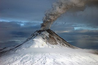
Redoubt Volcano, or Mount Redoubt, is an active stratovolcano in the largely volcanic Aleutian Range of the U.S. state of Alaska. Located at the head of the Chigmit Mountains subrange in Lake Clark National Park and Preserve, the mountain is just west of Cook Inlet, in the Kenai Peninsula Borough about 110 miles (180 km) southwest of Anchorage. At 10,197 feet (3,108 m), in just over 5 miles (8.0 km) Mount Redoubt attains 9,150 feet (2,790 m) of prominence over its surrounding terrain. It is the highest summit in the Aleutian Range. In 1976, Redoubt Volcano was designated as a National Natural Landmark by the National Park Service.
A volcano tectonic earthquake or volcano earthquake is caused by the movement of magma beneath the surface of the Earth. The movement results in pressure changes where the rock around the magma has a change in stress. At some point, this stress can cause the rock to break or move. This seismic activity is used by scientists to monitor volcanoes. The earthquakes may also be related to dike intrusion and/or occur as earthquake swarms. Usually they are characterised by high seismic frequency and lack the pattern of a main shock followed by a decaying aftershock distribution of fault related tectonic earthquakes.
Villarrica is one of Chile's most active volcanoes, rising above the lake and town of the same name, 750 km (470 mi) south of Santiago. It is also known as Rucapillán, a Mapuche word meaning "great spirit's house" or " the demon's house". It is the westernmost of three large stratovolcanoes that trend northwest to southeast obliquely perpendicular to the Andean chain along the Mocha-Villarrica Fault Zone, and along with Quetrupillán and the Chilean portion of Lanín, are protected within Villarrica National Park. Guided ascents are popular during summer months.
Volcanic gases are gases given off by active volcanoes. These include gases trapped in cavities (vesicles) in volcanic rocks, dissolved or dissociated gases in magma and lava, or gases emanating from lava, from volcanic craters or vents. Volcanic gases can also be emitted through groundwater heated by volcanic action.
Several types of volcanic eruptions—during which material is expelled from a volcanic vent or fissure—have been distinguished by volcanologists. These are often named after famous volcanoes where that type of behavior has been observed. Some volcanoes may exhibit only one characteristic type of eruption during a period of activity, while others may display an entire sequence of types all in one eruptive series.
The Silverthrone Caldera is a potentially active caldera complex in southwestern British Columbia, Canada, located over 350 kilometres (220 mi) northwest of the city of Vancouver and about 50 kilometres (31 mi) west of Mount Waddington in the Pacific Ranges of the Coast Mountains. The caldera is one of the largest of the few calderas in western Canada, measuring about 30 kilometres (19 mi) long (north-south) and 20 kilometres (12 mi) wide (east-west). Mount Silverthrone, an eroded lava dome on the caldera's northern flank that is 2,864 metres (9,396 ft) high, may be the highest volcano in Canada.
The Wells Gray-Clearwater volcanic field, also called the Clearwater Cone Group, is a potentially active monogenetic volcanic field in east-central British Columbia, Canada, located approximately 130 km (81 mi) north of Kamloops. It is situated in the Cariboo Mountains of the Columbia Mountains and on the Quesnel and Shuswap Highlands. As a monogenetic volcanic field, it is a place with numerous small basaltic volcanoes and extensive lava flows.
Alaska's Mount Redoubt volcano began erupting on March 22, 2009, and activity continued for several months.
A series of small volcanic earthquakes measuring less than 4.0 on the Richter magnitude scale took place in the sparsely populated Nazko area of the Central Interior of British Columbia, Canada, from October 9, 2007, to June 12, 2008. They occurred just west of Nazko Cone, a small tree-covered cinder cone that last erupted about 7,200 years ago.
A volcanic hazard is the probability a volcanic eruption or related geophysical event will occur in a given geographic area and within a specified window of time. The risk that can be associated with a volcanic hazard depends on the proximity and vulnerability of an asset or a population of people near to where a volcanic event might occur.
A lateral eruption or lateral blast is a volcanic eruption which is directed laterally from a volcano rather than upwards from the summit. Lateral eruptions are caused by the outward expansion of flanks due to rising magma. Breaking occurs at the flanks of volcanoes making it easier for magma to flow outward. As magma is pushed upward towards the volcano it diverges towards the flanks before it has a chance to erupt from the crater. When the expanding flank finally gives it releases a flow of magma. More explosive lateral eruptions are referred to as lateral blasts. Some of the most notable examples of a lateral eruption include Mount St. Helens, Mount Pelée, and Mount Etna.
The 2011–2012 El Hierro eruption occurred just off the island of El Hierro, the smallest and farthest south and west of the Canary Islands, in the Atlantic Ocean off the coast of Africa. The island is also the youngest in the volcanic chain. The October 2011 – March 2012 eruption was underwater, with a fissure of vents located approximately 2 kilometres to the south of the fishing village of La Restinga on the southern coast of the island. Increased seismicity in June 2012 to the north-west of the vent did not result in another phase of eruptive activity. Until the 2021 La Palma eruption, which started on 19 September 2021, this was the last volcanic eruption in Spain.
The 2014–2015 eruption of Bárðarbunga was a Hawaiian eruption in the Bárðarbunga volcanic system in Iceland, that began on 29 August 2014, and ended on 27 February 2015. The eruption emitted large volumes of sulphur dioxide and impacted air quality in Iceland. There was no effect on flights outside of the immediate vicinity due to a lack of a significant emission of volcanic ash. The eruption took place in the lava field of Holuhraun northeast of the Bárðarbunga caldera proper.
A multi-component gas analyzer system (Multi-GAS) is an instrument package used to take real-time high-resolution measurements of volcanic gases. A Multi-GAS package includes an infrared spectrometer for CO2, two electrochemical sensors for SO2 and H2S, and pressure–temperature–humidity sensors, all in a weatherproof box. The system can be used for individual surveys or set up as permanent stations connected to radio transmitters for transmission of data from remote locations. The instrument package is portable, and its operation and data analysis are simple enough to be conducted by non-specialists.
Sherman Crater is an active volcanic crater of Mount Baker in the U.S. state of Washington situated between Sherman Peak and Grant Peak.
This page is based on this Wikipedia article Text is available under the CC BY-SA 4.0 license; additional terms may apply. Images, videos and audio are available under their respective licenses.